Upper Inn Valley
| Upper Inn Valley | ||
|---|---|---|
| location | Tyrol , Austria | |
| Waters | Inn | |
| Mountains | Northern Limestone Alps , Central Alps | |
| Geographical location | 47 ° 13 ' N , 10 ° 43' E | |
|
|
||
| height | 600 to 800 m above sea level A. | |
| length | 90 km | |
| climate | inner alpine valley climate | |
The upper part of the Tyrolean Inn Valley is referred to as the Oberinntal , also known as the Tiroler Oberinntal .
geography
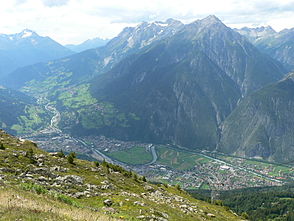
The Upper Inn Valley stretches from the border with the Swiss Engadin to the confluence of the Melach a few kilometers west of Innsbruck . The area between the border and Landeck is called the Upper Court . The Oberinntal is part of the Tyrolean Oberland .
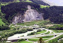
The valley is (excluding the Upper Court) around 90 km long and surrounded by mountains up to 3000 m high. It separates the Northern Limestone Alps from the higher Central Alps to the south . In contrast to the Lower Inn Valley , the Upper Inn Valley is narrower and in some places formed by gorges, for example near Zams and Roppen , or forms a landslide landscape at the entrance to the Ötztal . From Silz the valley floor is wider. The valley is partly accompanied by low mountain range terraces, including the Mieminger Plateau as the largest . The largest side valleys are the Pitztal and Ötztal from the south and the Stanzer and Gurgltal from the west and north.
The border between the Upper and Lower Inn Valley at the (old) Melach estuary near Zirl and the Meilbrünnl opposite the Inn near the Martinswand represents the old regional court boundary between Sonnenburg and Hörtenberg .
climate
Protected by the high mountain ranges, the Upper Inn Valley has a typical inner-Alpine valley climate. There is less rainfall than in the north or south alpine congestion areas , lots of sun in winter, little fog and wind. To the west and north of Landeck there is an abrupt transition to the high- precipitation reservoirs of the Arlberg area and the Lechtal Alps . On the other hand, precipitation decreases even further towards the south towards the main Alpine ridge (Ötztal, Upper Court). The mean annual precipitation for the years 1971-2000 in Haiming is 716.7 mm, in Imst 788.9 mm, in Landeck 753.6 mm and in Prutz 633.6 mm.
|
Monthly average temperatures and precipitation for Landeck ( 785 m above sea level )
Source:
|
|||||||||||||||||||||||||||||||||||||||||||||||||||||||||||||||||||||||||||||||||||||||||||||||||||||||||||||||||||||||||||||||||||||||||||||||||||||||||||||||||||||||||||||||||||||||||||||||||||
population
The town centers are mostly elevated on the alluvial cones of the brooks or on the low mountain range terraces. Meanwhile, the valley floor is also increasingly being used for settlements and, above all, for businesses. The largest towns and regional centers are the third largest municipality in Tyrol, Telfs (16,046 inhabitants), Imst (10,765), Zirl (8110) and Landeck (7633).
The form of the farms in the Upper Inn Valley is Rhaetian , in contrast to the Bavarian court forms of the Lower Inn Valley. The southern Bavarian dialects show individual characteristics of Alemannic , especially in the west .
Economy and Transport

There are several commercial locations in the Upper Inn Valley, but many residents still commute. Landeck, Imst and Telfs used to be centers of the textile industry. There are good conditions for agriculture in the wider valley sections and on the low mountain ranges. Due to the previously common real division , the corridor is more structured than in the Lower Inn Valley. In contrast to the side valleys, tourism only plays a minor role.
The Upper Inn Valley is an important traffic axis, the Arlberg Railway , the Inntal A12 motorway and the Tiroler Straße run here . In addition to the east-west traffic from Innsbruck towards Arlberg , the north-south traffic across the Alps from the Fernpass to Reschen , like the ancient Via Claudia Augusta , also uses part of the valley.
panorama
Web links
- "Oberinntal" picture collection in the Tirol Atlas of the University of Innsbruck
Individual evidence
- ^ A b Central Institute for Meteorology and Geodynamics: Climate data from Austria 1971–2000
- ^ Land Tirol: Planning associations Landeck and surroundings , Imst and surroundings , Inntal - Mieminger Plateau , Telfs and surroundings - Salzstraße


