
Tiroler Strasse
| State road B171 in Austria | |||||||||||||||||||||||||||||||||||||||||||||||||||||||||||||||||||||||||||||||||||||||||||||||||||||||||||||||||||||||||||||||||||||||||||||||||||||||||||||||||||||||||||||||||||||||||||||||||||||||||||||||||||||||||||||||||||||||||||||||||||||||||||||||||||||||||||||||||||||||||||||||||||||||||||||||||||||||||||||||||||||||||||||||||||||||||||||||||||||||||||||||||||||||||||||||||||||||||||||||||||||||||||||||||||||||||||||||||||||||||||||||||||||||||||||||||||||||||||||||||||||||||||||||||||||||||||||||||||||||||||||||||||||||||||||||||||||||||||||||||||||||||||||||||||||||||||||||||||||||||||||||||||||||||||||||||

|
|||||||||||||||||||||||||||||||||||||||||||||||||||||||||||||||||||||||||||||||||||||||||||||||||||||||||||||||||||||||||||||||||||||||||||||||||||||||||||||||||||||||||||||||||||||||||||||||||||||||||||||||||||||||||||||||||||||||||||||||||||||||||||||||||||||||||||||||||||||||||||||||||||||||||||||||||||||||||||||||||||||||||||||||||||||||||||||||||||||||||||||||||||||||||||||||||||||||||||||||||||||||||||||||||||||||||||||||||||||||||||||||||||||||||||||||||||||||||||||||||||||||||||||||||||||||||||||||||||||||||||||||||||||||||||||||||||||||||||||||||||||||||||||||||||||||||||||||||||||||||||||||||||||||||||||||||
| |
|||||||||||||||||||||||||||||||||||||||||||||||||||||||||||||||||||||||||||||||||||||||||||||||||||||||||||||||||||||||||||||||||||||||||||||||||||||||||||||||||||||||||||||||||||||||||||||||||||||||||||||||||||||||||||||||||||||||||||||||||||||||||||||||||||||||||||||||||||||||||||||||||||||||||||||||||||||||||||||||||||||||||||||||||||||||||||||||||||||||||||||||||||||||||||||||||||||||||||||||||||||||||||||||||||||||||||||||||||||||||||||||||||||||||||||||||||||||||||||||||||||||||||||||||||||||||||||||||||||||||||||||||||||||||||||||||||||||||||||||||||||||||||||||||||||||||||||||||||||||||||||||||||||||||||||||||
| Basic data | |||||||||||||||||||||||||||||||||||||||||||||||||||||||||||||||||||||||||||||||||||||||||||||||||||||||||||||||||||||||||||||||||||||||||||||||||||||||||||||||||||||||||||||||||||||||||||||||||||||||||||||||||||||||||||||||||||||||||||||||||||||||||||||||||||||||||||||||||||||||||||||||||||||||||||||||||||||||||||||||||||||||||||||||||||||||||||||||||||||||||||||||||||||||||||||||||||||||||||||||||||||||||||||||||||||||||||||||||||||||||||||||||||||||||||||||||||||||||||||||||||||||||||||||||||||||||||||||||||||||||||||||||||||||||||||||||||||||||||||||||||||||||||||||||||||||||||||||||||||||||||||||||||||||||||||||||
| Start of the street: | Kufstein ( 47 ° 36 ′ N , 12 ° 11 ′ E ) |
||||||||||||||||||||||||||||||||||||||||||||||||||||||||||||||||||||||||||||||||||||||||||||||||||||||||||||||||||||||||||||||||||||||||||||||||||||||||||||||||||||||||||||||||||||||||||||||||||||||||||||||||||||||||||||||||||||||||||||||||||||||||||||||||||||||||||||||||||||||||||||||||||||||||||||||||||||||||||||||||||||||||||||||||||||||||||||||||||||||||||||||||||||||||||||||||||||||||||||||||||||||||||||||||||||||||||||||||||||||||||||||||||||||||||||||||||||||||||||||||||||||||||||||||||||||||||||||||||||||||||||||||||||||||||||||||||||||||||||||||||||||||||||||||||||||||||||||||||||||||||||||||||||||||||||||||
| End of street: | Pardöll (Gem. Flirsch ) ( 47 ° 8 ′ N , 10 ° 25 ′ E ) |
||||||||||||||||||||||||||||||||||||||||||||||||||||||||||||||||||||||||||||||||||||||||||||||||||||||||||||||||||||||||||||||||||||||||||||||||||||||||||||||||||||||||||||||||||||||||||||||||||||||||||||||||||||||||||||||||||||||||||||||||||||||||||||||||||||||||||||||||||||||||||||||||||||||||||||||||||||||||||||||||||||||||||||||||||||||||||||||||||||||||||||||||||||||||||||||||||||||||||||||||||||||||||||||||||||||||||||||||||||||||||||||||||||||||||||||||||||||||||||||||||||||||||||||||||||||||||||||||||||||||||||||||||||||||||||||||||||||||||||||||||||||||||||||||||||||||||||||||||||||||||||||||||||||||||||||||
| Overall length: | 166.323 km | ||||||||||||||||||||||||||||||||||||||||||||||||||||||||||||||||||||||||||||||||||||||||||||||||||||||||||||||||||||||||||||||||||||||||||||||||||||||||||||||||||||||||||||||||||||||||||||||||||||||||||||||||||||||||||||||||||||||||||||||||||||||||||||||||||||||||||||||||||||||||||||||||||||||||||||||||||||||||||||||||||||||||||||||||||||||||||||||||||||||||||||||||||||||||||||||||||||||||||||||||||||||||||||||||||||||||||||||||||||||||||||||||||||||||||||||||||||||||||||||||||||||||||||||||||||||||||||||||||||||||||||||||||||||||||||||||||||||||||||||||||||||||||||||||||||||||||||||||||||||||||||||||||||||||||||||||
|
State : |
|||||||||||||||||||||||||||||||||||||||||||||||||||||||||||||||||||||||||||||||||||||||||||||||||||||||||||||||||||||||||||||||||||||||||||||||||||||||||||||||||||||||||||||||||||||||||||||||||||||||||||||||||||||||||||||||||||||||||||||||||||||||||||||||||||||||||||||||||||||||||||||||||||||||||||||||||||||||||||||||||||||||||||||||||||||||||||||||||||||||||||||||||||||||||||||||||||||||||||||||||||||||||||||||||||||||||||||||||||||||||||||||||||||||||||||||||||||||||||||||||||||||||||||||||||||||||||||||||||||||||||||||||||||||||||||||||||||||||||||||||||||||||||||||||||||||||||||||||||||||||||||||||||||||||||||||||
 |
|||||||||||||||||||||||||||||||||||||||||||||||||||||||||||||||||||||||||||||||||||||||||||||||||||||||||||||||||||||||||||||||||||||||||||||||||||||||||||||||||||||||||||||||||||||||||||||||||||||||||||||||||||||||||||||||||||||||||||||||||||||||||||||||||||||||||||||||||||||||||||||||||||||||||||||||||||||||||||||||||||||||||||||||||||||||||||||||||||||||||||||||||||||||||||||||||||||||||||||||||||||||||||||||||||||||||||||||||||||||||||||||||||||||||||||||||||||||||||||||||||||||||||||||||||||||||||||||||||||||||||||||||||||||||||||||||||||||||||||||||||||||||||||||||||||||||||||||||||||||||||||||||||||||||||||||||
| B 171 Tiroler Straße at km 11.0 | |||||||||||||||||||||||||||||||||||||||||||||||||||||||||||||||||||||||||||||||||||||||||||||||||||||||||||||||||||||||||||||||||||||||||||||||||||||||||||||||||||||||||||||||||||||||||||||||||||||||||||||||||||||||||||||||||||||||||||||||||||||||||||||||||||||||||||||||||||||||||||||||||||||||||||||||||||||||||||||||||||||||||||||||||||||||||||||||||||||||||||||||||||||||||||||||||||||||||||||||||||||||||||||||||||||||||||||||||||||||||||||||||||||||||||||||||||||||||||||||||||||||||||||||||||||||||||||||||||||||||||||||||||||||||||||||||||||||||||||||||||||||||||||||||||||||||||||||||||||||||||||||||||||||||||||||||
|
Course of the road
|
|||||||||||||||||||||||||||||||||||||||||||||||||||||||||||||||||||||||||||||||||||||||||||||||||||||||||||||||||||||||||||||||||||||||||||||||||||||||||||||||||||||||||||||||||||||||||||||||||||||||||||||||||||||||||||||||||||||||||||||||||||||||||||||||||||||||||||||||||||||||||||||||||||||||||||||||||||||||||||||||||||||||||||||||||||||||||||||||||||||||||||||||||||||||||||||||||||||||||||||||||||||||||||||||||||||||||||||||||||||||||||||||||||||||||||||||||||||||||||||||||||||||||||||||||||||||||||||||||||||||||||||||||||||||||||||||||||||||||||||||||||||||||||||||||||||||||||||||||||||||||||||||||||||||||||||||||
The Tiroler Straße B 171 is a state road in Austria . It runs over a length of 166.323 km of Kufstein according Pardöll (municipality Flirsch ) through the Tyrol Inntalautobahn to Landeck , parallel to Inntalautobahn , and then through the Stanzertal towards Arlberg .
history
The Arlberger Straße from Innsbruck to Arlberg, the Salzburger Straße from Innsbruck to Lofer and the Kufsteiner Straße from Wörgl to Kiefersfelden are among the federal highways established by the federal law of July 8, 1921. Until 1938 the road between Bregenz and Vienna was designated as B 1, after the connection of Austria this road was led as part of Reichsstraße 31 until 1945 . The Kufsteiner Straße was designated as the B 65 until 1938, after the annexation of Austria this street was part of the Reichsstraße 15 until 1945.
course
State border at Kufstein ( Kiefersfelden ) - (Untere Schranne Wildbichler Strasse B 175), ( Sölllandl Eiberg Strasse B 173) - Wörgl - (Sölllandl Loferer Strasse B 178) - Brixlegg ( Alpbachtal ) - Wiesing ( Achensee Achensee Strasse B 181, Zillertal Zillertal Strasse B 169) - Schwaz - Hall in Tirol - Innsbruck ( Wipptal Brenner Strasse B 182) - Zirl ( Seefelder Plateau Seefelder Strasse B 177) - Telfs ( Mieminger Plateau Mieminger Strasse B 189) - Haiming ( Ötztal Ötztal Strasse B 186) - Imst ( Nassereith Mieming road B 189 and Pitztal ) - Landeck (Oberinntal Reschen road B 180) - Pians ( Paznauntal ) - Flirsch / Pardöll ( Stanzertal ).
Branches
- B 171a (Tiroler Straße junction Hall i. T.)
Hall in Tirol (B 171) - Ampass (A 12 - connection Hall Mitte). This branch is divided into two further branches, which however do not have their own street name. Total length 1.52 km.
- B 171b (Tiroler Straße junction Völs)
Innsbruck (B 171) - Völs (A 12 - connection Innsbruck-Kranebitten). Length 1.31 km.
expansion
- The entire Haller Strasse in Innsbruck and the adjoining local area of Neu-Rum, as well as the open-air route between Rum and Hall in Tirol, are 4-lane expanded, the completion in August 2011.
- The Wörgl bypass has been planned for a long time. The western section with a length of 2.1 km has been built and vehicles over 7.5 t can be used up to the companies in the industrial zone. A completion date for the missing eastern construction lot including a new roundabout at the Wörgl-Ost motorway slip road is not yet known.
Traffic restrictions for through traffic
Driving ban for trucks over 7.5 tonnes is prescribed on the following sections of the B 171 (as of July 4, 2010):
- from km 0.000 to km 1.690
- from km 1.984 to km 3.857
- from km 10.995 to km 14.650
- from km 15.442 to km 16.766
- from km 20.776 to km 24.109
- from km 31.578 to km 32.640
- from km 49.125 to km 53.625
- from km 63.760 to km 66.520
- from km 82.660 to km 83.725
- from km 88.775 to km 90.930
- from km 103.520 to km 104.440
- from km 115.550 to km 121.155
- from km 135.220 to km 148.800
- from km 148.750 to km 154.800
- from km 158.600 to km 166.323
gallery

Start of the B 171 at the border with Bavaria

B 171 at Kundl
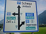
Signpost west of Strass in the Zillertal
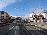
Innsbruck, Höttinger Au to the west
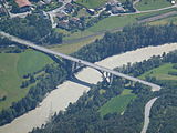
Inn bridge near Roppen
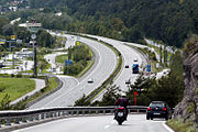
View from the B 171 to the A 12 with the Trofana Tyrol service area in Mils near Imst


Web links
Individual evidence
- ↑ a b Office of the Tyrolean Provincial Government (Ed.): Statistisches Handbuch Bundesland Tirol 2019. Innsbruck 2019, p. 11 ( PDF; 14.2 MB )
- ↑ Regulations & driving bans , search: "171" (as of July 4, 2010).
| B171 | Like the other former federal highways, Tiroler Straße was part of the federal administration. Since April 1, 2002, it has been under state administration and continues to have the B in the number, but not the name Bundesstraße. |