Klosterneuburger Strasse
| State road B14 in Austria | |

|
|
| map | |
| Basic data | |
| Overall length: | 48.6 km |
|
State : |
|
| Elevated route in the Nussdorf area (built in 1983) | |
|
Course of the road
|
|
| State road B14b in Austria | |

|
|
| map | |
| Basic data | |
| Overall length: | 2.0 km |
|
State : |
|
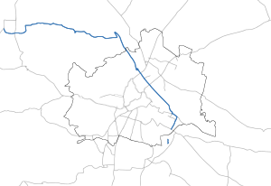
The Klosterneuburger road B 14 is a main road B in Vienna , national road B in Lower Austria and former federal highway . It runs over a length of 48.6 km from Tulln on the Danube via Klosterneuburg to Vienna- Simmering .
An extension of the B 14 to Rannersdorf is being planned. The 2 km long “Spange Rannersdorf”, the section to the north and south of the junction on the Vienna outer ring expressway S 1, has already been completed.
Vienna
In the urban area of Vienna , the name Klosterneuburger Straße is not in use for this street, as a street in the 20th district of Vienna, Brigittenau , is called that. The names of the local streets are used. From south to north, the B 14 in Vienna encompasses the traffic areas Etrichstrasse, Zinnergasse, Artillerieplatz, Margetinstrasse, Jedletzbergerstrasse (all in the 11th district), Seitenhafenbrücke (2nd / 11th district), Seitenhafenstrasse, Hafenzufahrtsstrasse (both in the 2nd district), Handelskai (2nd / 20th district) and Heiligenstädter Straße (19th district). From the port access road, the B 14 follows the course of the Danube upstream.
The section of the B 14 between Friedrich-Engels-Platz (access ramp to Floridsdorfer Brücke , 20th district) and Nussdorf (19th district) is in the rank of a car road . It leads north under the north bridge and crosses the Danube Canal at the extensive Nussdorf junction that connects to the bridge , where there is also a connection to the Nussdorfer Lände B 227 towards the city along the Danube Canal in the 19th district. In the south direction, the southern part of the Nussdorf junction is used. From both directions there is a connection to the north bridge at this virtual roundabout and via this to the left bank of the Danube bank motorway A 22 in the 21st district.
Branch lines
The Brigittenauer Brücke was originally part of the Danube bank A22 motorway . In 1997, in the course of the introduction of the motorway vignette in Austria, it was downgraded to a road so that the bridge could be used without a vignette. Since then it has had the street name B 14a .
The branch line B 14b branches off from the B 14 at the side port bridge and leads over the Alberner port access road to the port of Albern .
history
In 1834 Klosterneuburger Strasse had a toll station in Nussdorf, which brought in around 1,500 guilders for the state treasury. Because of its low supra-regional importance, this road was handed over to the state of Lower Austria in 1869 and run as a state road. The Lower Austrian state road law of April 19, 1894 no longer used the term state road, the previous state roads were converted into first class district roads.
After the annexation of Austria , this road was converted into a first order road on April 1, 1940 as part of the standardization of the road system and designated as LIO 38. With the entry into force of the Lower Austrian Road Act of July 12, 1956, the former district roads were converted into state roads and today's Mannersdorfer Strasse was designated as L 116 .
The Klosterneuburg Tullner street belonged from 1 April 1959, the network of federal roads in Austria . From July 1, 1964, the section of the route between Heiligenstadt and Klosterneuburg located in the city of Vienna was also considered a federal highway.
In the 1990s, the section between the north bridge and Simmeringer Hauptstrasse was part of Budapester Strasse B 10.
In 2002 the B 14 was transferred to the state administration by the Federal Roads Transfer Act.
In 2008 the first section of the Klosterneuburg bypass was opened, which is already signposted as the B 14. Until the opening of the last section, the “Martinstunnel”, the main route of the B 14 will continue through the urban area of Klosterneuburg.
Web links
Individual evidence
- ↑ Law of April 19, 1894, regarding the construction and maintenance of public, non-Aryan roads and paths, effective for the Archduchy under the Enns. LGBl. No. 20/1894.
- ^ Ordinance and official gazette for the Reichsgau Niederdonau , year 1940, p. 179.
- ↑ Federal Act of March 18, 1959, with which the Federal Roads Act is again amended, Directory H.
- ↑ Federal Act of June 3, 1964, regarding the amendment of the Federal Roads Act, Directory J.
- ↑ Federal Roads Act 1994
| B14 | Like the other former federal highways, Klosterneuburger Strasse was part of the federal administration. Since April 1, 2002, it has been under state administration and continues to have the B in the number, but not the name Bundesstraße. |


