
Danube Canal

_River_Path_Openstreetmap.png)
The Danube Canal is the closest branch of the Danube to the city center in Vienna . It was once also called Wiener Wasser or Wiener Arm . The proposed term Little Danube for him has not caught on.
The 17.3 km long Danube Canal branches off from the new main stream flooded in 1875 near Nussdorf just before the Nussdorf weir and lock system on the border of the 20th and 19th districts and flows out near the Albern harbor at the so-called Praterspitz on the border of the 2nd district. to the 11th district back into him. It separates the unified river island that was created when the Danube was regulated until 1875 and is divided between Vienna's districts 2 ( Leopoldstadt ) and 20 ( Brigittenau ) from the inner city and the other city districts on the right bank. The entire length of the water area of the Danube Canal belongs to the 20th and 2nd district, the borders of which on the right bank run towards districts 19, 9, 1, 3 and 11, which follow one another downstream.
course


In the Middle Ages, the course of today's Danube Canal was the main arm of the Danube. The city of Vienna developed on a flood-proof terrace on its southwestern bank. The Danube used to have frequent floods, which repeatedly changed the bed. The main stream shifted again and again. Around 1700, since the main river now flowed far to the east, the name "Danube Canal" was used for the arm close to the city. This was first regulated in 1598–1600. In the 1830s, his bed was moved from the Mauthner water that still exists today at the pleasure house in the straight line between the gasworks and Freudenau . In the course of the Danube regulation from 1868–1875, the Danube Canal was expanded again, in particular the inlet structure at Nussdorf and the mouth at Albern.
shipping
The Danube Canal was important for passenger and cargo shipping for centuries, as it offered land in the immediate vicinity of the city of that time. In 1855, the new headquarters of the First Danube Steamship Company , until 1918 the largest inland shipping company in Europe, was opened at the mouth of the Vienna River and the Danube Canal on the edge of the old town. Plans to use the canal for freight shipping even after the Danube regulation was completed in 1875 soon proved to be obsolete, as rail and road connections as well as warehouses were much easier to create at the trading quay of the new Danube river than close to the ever expanding settlement area of the growing Big city. A considerable part of the passenger shipping also took place on the main stream, but part of it continued to use the Danube Canal. In 2010, the new Wien City boat station was opened at Schwedenplatz , from which the Twin City Liner to Pressburg / Bratislava and tour boats operate.
Infrastructure
On the basis of the law of July 18, 1892, the Commission for Transport Systems in Vienna set up the Vienna City Railway in the 1890s and at the same time made provisions for the expansion of the Danube Canal. The Danube Canal line was the last of the lines in the Vienna light rail network to open in 1901; the route runs along the Danube Canal at the level of the Vorkais, mostly in galleries, and has four stations here: Brigittabrücke, today Friedensbrücke , Elisabethpromenade, today Rossauer Lände , Schottenring and Ferdinandsbrücke, today Schwedenplatz . It was part of the Vienna Electric Light Railroad from 1925 and was gradually converted to underground operation from 1976. Today it is part of the U4 . In 1996 the Spittelau underground station (U4, U6) was added in the north ; from there to Friedensbrücke the U4 runs in an open cut.
From 1901 to 1906, the Kaiserbadschleuse (2nd / 1st district) was built as part of a planned lock staircase, but it never went into operation. Otto Wagner designed the rifle house for the lock - Schütz is the name of the movable metal plate of a weir ; The riflemen were to be kept in the rifle house when the weir was out of order - the building opposite the Schottenring subway station in the 2nd district on the left bank of the canal at the level of the front quay was revitalized as a restaurant. Considerations to expand the Danube Canal into a trading port soon proved to be obsolete, as there was considerably more space available on the regulated Danube river and the connection to the railway lines was much easier there.
Because it opens up the city center of Vienna, from the middle of the 20th century thought was given to developing the area of the Danube Canal as an important axis for private transport . In the 1960s, a city motorway was planned across Vienna; the urban planning study on the Danube Canal (Viktor Hufnagl, Traude and Wolfgang Windbrechtinger ), which was carried out in 1971, rejected this, however, because this use would impair the recreational value and the climatic function of the Danube Canal. The city motorway project was then officially rejected in a declaration of principle by the Mayor of Vienna Felix Slavik in early September 1972 (see daily press of September 3, 1972). As a result, however, a few kilometers of motorway-like secondary roads (today: B 227 ) were built north and south of the center, including the Nussdorf junction in 1980–1983 and the two lanes of the east motorway A4 with the cable-stayed bridge over the canal in the southern part of the Danube Canal until 1975 .
The collapse of the Vienna Reichsbrücke on August 1, 1976 blocked shipping traffic on the Danube until a provisional navigation channel was built. As an emergency measure, around 150 ships or barges were diverted through the Danube Canal by September 29, 1976. But because the construction work on the U1 subway line at Schwedenplatz narrowed the Danube Canal at that time, its use was only possible to a limited extent. According to experience gained in the early days, the permitted draft of the ships and barges passing through was limited to a maximum of around 120 centimeters and their maximum load to around 450 tons. Eight small tug and tug boats and a bulldozer on land assisted the passing watercraft. With a special permit, the DDSG-Schub lighter 17006 with 600 tons of cargo drove through the canal on September 24, 1976, making it the heaviest watercraft (to date) that has ever sailed the Danube Canal.
.JPG)
In 2012, the Danube Canal will be crossed by 22 road and six railway bridges as well as five pedestrian walkways. The Schemmerl or more correctly Schemerl Bridge of the Nussdorf lock by Otto Wagner with the associated administration building replaced the former floating gate and is the first bridge in the direction of flow. Despite the objections of the Federal Monuments Office , the stilt motorway built right next to it along the canal bank at the Nussdorf junction has a considerable adverse effect on the urban planning effect of Otto Wagner's design. The Winterhafenbrücke , a railway bridge, which has been passable again after more than 60 years since 2008 , is the last before the estuary. The side port bridge in the lower part of the Danube Canal near the Danube port Freudenau was opened in 2011 as the newest bridge .
Since May 10, 2008, U-Bahn users have been able to cross under the Danube Canal on foot because the platforms of the new U2 station Schottenring (exit in the 1st district) are located across the river bed and there is also an exit to Herminengasse in the 2nd district. District exists.
Danube Canal Bank

In the first half of April 1945 there were heavy artillery duels between the Red Army , which had already conquered the Inner City, and the German Wehrmacht , which still held Leopoldstadt, at the Battle of Vienna . The Franz-Josefs-Kai on the bank of the Danube Canal towards the old town and the opposite part of the Leopoldstadt canal bank lost most of the facades and houses designed in the representative Ringstrasse style; they were replaced by mostly architecturally unsatisfactory new buildings (example: Dianabad ).
The working group that met in the wake of the urban development ideas competition on the Danube Canal in 1946 wanted the left, more sunny canal bank in the 2nd district to be designed as a leisure promenade. Later, plans for road extensions repeatedly competed with this project. Especially in the “green conscious” 1970s, the old post-war plans were also pushed by the city administration, but have only been partially implemented to this day. For a long time it has been the aim of Vienna's urban policy to include the Danube Canal more strongly in Viennese city life. So there are always suggestions for new buildings near the shore, large-scale cladding, water taxis, floating hotels and the like. In the recent past, several construction projects have created a waterfront , particularly in the section of the bank between the Ringturm and Urania . The Schwedenplatz and Morzinplatz area will also be completely redesigned over the next few years.
For the canal bank in the 3rd district see: Weißgerberlände .
Recreational use
Since the late 19th century there have been summer baths on the Danube Canal, wooden bathing boats, in which you can step into the water in a water area enclosed by cabins and so invisible from the outside; after the Second World War they were abandoned due to the poor water quality.

Due to its central location, the Danube Canal has increasingly developed into a leisure and recreation area thanks to numerous infrastructure projects. In 1995, the music venue “ Flex ” was established on the front quay near the Ringturm and in 1996 the “Summer Stage” with open-air exhibitions and concerts as well as restaurants and bars at the Roßauer Lände underground station . After 2006 the “Badeschiff” with swimming pool and café-restaurant was put into operation at Urania . Also in the neighboring "Schiffstation City", which opened in 2010, the landing stage of the Twin City Liner , gastronomy is offered in the "Motto am Fluss". At the confluence of the Wien River , the "Herrmann Beach Bar" has been located since 2005 with a heaped sandy beach. Opposite the “Flex” is the summery “Tel Aviv Beach” since 2009. Several annual music festivals offer concerts along the Danube Canal from summer to autumn. Since 2007, the Danube Canal has been running on stages built for this purpose on the promenade and in several bars with free admission . As part of the Waves Vienna club festival, which was held for the first time in 2011, bands play on several boats, including in the hold of the "Badeschiffs" and in "Flex", and the Vienna Jazz Festival has concerts on the "Summer Stage" in its program.
The lower Danube Canal is used to fish with staves .
Owner, lease, tender
In 2017, the Court of Auditors complained that the rents for properties on the Danube Canal were too low. The leasing of the pre-quay area at the Badeschiff, the Adria restaurant and some other restaurants from November 2018 was put out to tender by the Danube Flood Protection Competition (DHK), which consists of the three curiae federal government, the state of Lower Austria and the city of Vienna. DHK is the landowner of the gastronomic areas on the Danube Canal. Gerold Ecker, leaseholder of the Badeschiff, sued for omission because of "non-transparent and non-equality search for interested parties." In 2017/2018, various areas on the bank of the Danube Canal near the center were put out to tender or allocated for gastronomic use.
Buildings


The following structures stand along the Danube Canal:
- Inlet structure of the Nussdorf weir and lock system (19th and 20th district)
- Spittelau waste incineration plant designed by Friedensreich Hundertwasser (9th district)
- Zaha Hadid House above an old light rail arch (9th district)
- Friedensbrücke and Rossauer Lände underground stations (built by Otto Wagner , 9th district)
- Rossauer Kaserne (9th district)
- Ringturm (1st district)
- Schützenhaus from Otto Wagner (2nd district)
- Raiffeisen-Holding Hochhaus (2nd district)
- Ruprechtskirche (1st district)
- City ship station (1st district)
- Media Tower by Hans Hollein (2nd district)
- Uniqa hotel and business building by Jean Nouvel (2nd district)
- Badeschiff Vienna (1st district)
- Urania (1st district)
- Uniqa Tower (2nd district)
Note: Down the river are the districts 19. ( Döbling ), 9. ( Alsergrund ), 1. ( Inner City ), 3. ( Landstrasse ) and 11. ( Simmering ) on the right; 20th ( Brigittenau ) and 2nd ( Leopoldstadt ) district on the left bank of the Danube Canal.
Limnology
As new limnological research by the University of Vienna shows, the Danube Canal is a retreat for numerous fish species. There are around 30 species of fish, some of which are endangered in the Danube itself. Especially at the mouth of the Wien there are spawning grounds for noses that cannot get upstream due to unfavorable regulation of the Wien river. The Vienna estuary is therefore a popular place for hobby fishermen .
Flow channel
In March – June 2014 a 30 m long and 5 m wide research channel from the Danube to the Danube Canal was dug and concreted in Brigittenau not far from the inlet. The flow channel uses a 3 m gradient between the Danube and the Danube Canal and therefore works without pumps and can pass up to 10 cubic meters of water per second. The University of Natural Resources and Life Sciences conducts flow tests on the behavior of rivers.
Others
In 1998, 1999 and 2000, cancer researcher Siegfried Knasmüller found heterocyclic aromatic amines in the water of the canal that are dangerous to health.
gallery

The Nussdorf weir system , 19th and 20th district

The Danube Canal in Spittelau between the 9th and 20th district

Augarten Bridge and Rossauer Bridge as seen from the Ringturm

Otto Wagner's rifle house

Danube Canal upstream, seen from Schwedenplatz ; left behind the Ringturm , in front the IBM house, 2nd district

Urania , Sweden Bridge and Blue Danube tour ship

The Badeschiff on the banks of the 1st district near the Aspern Bridge

The Vienna River flows into the Danube Canal, behind which the Federal Ministry for Transport, Innovation and Technology

The Danube Canal downstream with a view from the mouth of the Vienna River to the Franzensbrücke , 2nd and 3rd district

Erdberger Steg built on the site of the last Danube Canal ferry (ship in the picture: Twin City Liner )

Banks of the Danube Canal in the area of the 2nd and 3rd districts, seen from the Erdberger Steg, largely unchanged for decades
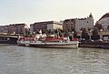
DFS Johann Strauss, Danube Canal berth, August 1989

Typical for the Danube Canal are the so-called Otto Wagner railings , as here at the Salztorbrücke
.JPG)


literature
- Bertrand Michael Buchmann , Harald Sterk , Rupert Schickl: The Danube Canal. History - planning - execution . Magistrate of the City of Vienna - Urban Development and Renewal Business Group (MA 19), Vienna 1984 ( contributions to urban research, urban development and urban design . 14, ZDB -ID 263948-8 ).
- Eric A. Leuer: A stepchild of the city? Public space on the Vienna Danube Canal . Grin, Munich, 2010, ISBN 978-3-640-50494-7 .
- Alfred Karrer: The collapse of the Reichsbrücken in 1976. A stream of traffic squeezes through the Danube Canal . Fuchs, Vienna 2002, ISBN 3-9501581-3-8 .
- Dieter Klein , Martin Kupf , Robert Schediwy : Vienna, cityscape losses since 1945. A critical documentation . 2nd Edition. Edition Atelier, Vienna 2002, ISBN 3-85308-054-5 .
- Judith Eiblmayr, Peter Payer: The Danube Canal. The discovery of a Viennese urban landscape . With an essay in texts and pictures by Christiane Zintzen . Metro, Vienna 2011, ISBN 978-3-99300-031-8 .
- Peter Hetzmannseder, Andreas Belwe: Danube Canal - A homage. Folio Verlag, Bozen / Vienna 2018, ISBN 978-3-85256-748-8 .
Web links
- Entry on the Danube Canal in the Austria Forum (in the AEIOU Austria Lexicon )
- Danube Canal - target area for urban development on the wien.at website
- Vienna Danube Canal: surprising variety of fish on ORF Science
Individual evidence
- ↑ William Czelechowski: Low Danube Canal. Retrieved April 14, 2016 .
- ^ Longest Waters wien.gv.at, accessed December 7, 2019.
- ↑ RGBl. No. 109/1892 (= p. 621 ff.)
- ^ City of Vienna Prize winners of the Danube Canal competition: Mathäus Schlager and Hans Steineder, Herbert Prehsler, Richard Winkler and Max Opravil, Karl Lachner, Egon Fridinger, Eugenie Pippal-Kottnig , Lois Welzenbacher , Albert Hein, Rudolf Weiss. RK November 23, 1946
- ↑ Archive report of the town hall correspondence: City boat station opened: Vienna has its city port , July 15, 2010
- ↑ Danube Canal Drift
- ↑ Gastronom sues against "expropriation" orf.at, January 22nd, 2018, accessed January 2nd, 2018.
- ↑ Note water level difference
- ↑ Research in artificial flumes orf.at, June 24, 2014, accessed December 7, 2019.
- ↑ Hydraulic engineering tests on the artificial river between the Danube Canal and the Danube vienna.at, June 30, 2014, accessed December 7, 2019.
- ↑ Tina Goebel: waves of indignation , in: profil , Vienna, No. 34/2008, pp. 94–95
- ↑ Wild story of the water tester in derStandard.at from August 10, 2008
Nussdorf weir and lock system | Embankment bridge | Suburban line Danube Canal Bridge | Nussdorf node | Nussdorfer Steg | Nussdorf Bridge | Heiligenstadt Bridge | Döblinger Steg | Belt Bridge | Spittelau Bridge | U6 Danube Canal Bridge | Spittelauer Steg | Peace Bridge | Siemens-Nixdorf-Steg | Rossauer Bridge | Augarten Bridge | Salt Gate Bridge | Marienbrücke | Sweden Bridge | Aspern Bridge | Danube Canal Pipe Bridge | Franzensbrücke | Connecting railway bridge | Rotunda Bridge | Erdberger footbridge | Stadium bridge | Erdberger Bridge | Gas works walkway | Ostbahnbrücke | Cable bridge | Cable-stayed bridge | Side harbor bridge | Freudenau Harbor Bridge | Winterhafenbrücke
Coordinates: 48 ° 12 ′ 47 " N , 16 ° 22 ′ 31" E