Franz-Josefs-Kai
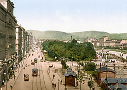
The Franz-Josef-Kai in the 1st District of Vienna , Inner City , is about 50 to 100 m wide and leads to 1.3 km long on the right bank of the Danube Canal along. It forms the north-eastern quarter of the street that encircles Vienna's old town and can only be driven clockwise for private traffic and extends from Maria-Theresien-Straße, the border to the 9th district, and from the Ringturm (Schottenring), along Morzinplatz and Schwedenplatz , to to Julius-Raab-Platz ( Urania , Stubenring); better known is the other part from Urania to Ringturm, the Vienna Ringstrasse. According to road construction law, the quay is part of Donaukanalstrasse (B227) , a Viennese state road.
history


The history of the Viennese city walls , their demolition and the layout of the street around the old town is shown in detail here .
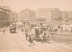
The quay , as the Viennese usually call it, was created in 1858–1860 as part of the demolition of the city wall, which began in March 1858 at the Rotenturm Bastion and thus on today's quay, and named after Emperor Franz Joseph I , who commissioned the Razing of the walls around his royal seat. At that time the quay was considered to be almost as representative as the Ringstrasse and had buildings in the typical Ringstrasse style (see: Historicism ); most of them were destroyed in artillery duels between the German Wehrmacht and the Red Army in the Battle of Vienna . The remaining, rebuilt 5- to 6-storey residential buildings date largely from the early days .
After 1945, when two narrow, only ruins-flanked parallel streets to the quay at the confluence of Rotenturmstrasse , Adlergasse (towards Schwedenplatz ) and Kohlmessergasse (towards Morzinplatz ) were opened, these two squares were more than doubled in the course of the quay and have since merged optically (even if not with regard to the house numbers). This made them much more attractive to pedestrians and shops. The results of an ideas competition announced in 1946 for the large-scale redesign of the Danube Canal zone were not implemented. Lois Welzenbacher presented the most radical project : In addition to a few high-rise buildings, buildings should have been erected in a rhythmic sequence perpendicular to the Danube Canal (and thus also to the Franz-Josefs-Kai).
In the 1960s, in the northern part of the quay between Schottenring , corner of the Ringturm , and Salztorbrücke, the four-lane carriageway on the entire quay was relocated to the outside of the green spaces on the river side; this greatly enlarged the pedestrian areas along the houses. This also created a separate track for the tram, which was later extended to the entire quay.
The roads connecting to the Franz-Josefs-Kai north and east along the right bank of the Danube Canal , also parts of the B227, have different names (north: Rossauer Lände ; east / southeast: Uraniastraße , Obere Weißgerberstraße, Dampfschiffstraße, Weißgerberlände , Erdberger Lände etc.) and are less wide. Down the river from the stadium bridge , the road merges into the eastern motorway (A4) towards Vienna Airport and Budapest .
Buildings, roads, bridges
The list starts at the north end of the wharf. Numbers listed are serial numbers (commonly known as house numbers) of the quay. The five bridges (they were destroyed in 1945) lead to the 2nd district of Vienna , the Leopoldstadt , which extends on the southern part of the island formed by the Danube Canal and the Danube.
- Augartenbrücke (as an extension of Maria-Theresien-Straße, which runs parallel to Schottenring), northern end of Franz-Josefs-Kai. The bridge marks the border between the 1st and 9th district.
- Nos. 63 and 65: This block of houses outside the Ringstrasse is, which is little known, part of the Franz-Josefs-Kai.
- No. 59 and 61: Ringturm . It marks the corner of Schottenring, the supposed northern end of the quay, which actually extends to the Augarten Bridge.
- "Flex" : well-known music club in a disused subway shaft, accessible from the front quay (stairs at the Augartenbrücke)
- Schottenring underground station (U2, U4): opposite the Ringturm on the quay
- No. 37: "Gothic House", built by Heinrich Ferstel 1860–1862
- Salztorbrücke (named after the city gate demolished in 1759, this after the salt trade once operated here)
- Opposite the bridge: Salztorgasse (important access to the old town, line 2A)
- Nos. 31 and 33: Leopold-Figl- Hof on the property of the Hotel Métropole , which was destroyed in 1945 , since 1938 Vienna headquarters of the Gestapo (sacrificial memorial room , Salztorgasse entrance)
- Morzinplatz : It extends the street space of the quay towards the old town; The Ruprechtskirche , one of the oldest in Vienna , stands on one step, accessible via the Ruprechtsstiege . The block to the right of the staircase has the addresses Morzinplatz 1 and 2, the side of the Leopold-Figl-Hof facing Morzinplatz has no. 4 (former main entrance to the hotel). There are no other house numbers; the block to the left of the staircase has the address Franz-Josefs-Kai 29.
- Memorial in memory of the victims of the Gestapo (on Morzinplatz opposite No. 4)
- No. 25–29: Until 1954, Kohlmessergasse ran parallel to the quay from Morzinplatz to Rotenturmstrasse, to which the 110 m long, 6-storey Herminenhof, built after 1887 in late historical style, was connected. The enormous building was destroyed in the Battle of Vienna in 1945 , and the building site was then replaced by a green area.
- Marienbrücke (with a 5 m high Art Nouveau Madonna)
- Opposite the bridge: junction of Rotenturmstraße coming from Stephansplatz, the city center, the exit from this part of the old town (line 2A); the corner house Franz-Josefs-Kai 23, originally a hotel, was built in 1889 by Wilhelm Fraenkel . Here was the Rotenturm Gate, where the demolition of the city wall, a prerequisite for the construction of the Franz-Josefs-Kai, began in March 1858.
- No. 13–23: Until 1954, the Adlergasse leading from Rotenturmstrasse to Schwedenplatz ran parallel to the quay and was joined by a block on the quay side; it was destroyed in 1945 and the area was then used to expand Schwedenplatz.
- On the fore quay: Wien City boat station
- Schwedenplatz underground station (U1, U4)
- Schwedenbrücke (between Schwedenplatz, Taborstraße and Praterstraße , named as thanks for Swedish help after the First World War)
- Schwedenplatz : It only has house numbers in its inventory before 1945. No. 1 was the side of the block between Adlergasse and Kai, which was destroyed in 1945, and does not exist today, No. 2 is the corner house on Laurenzerberg, No. 3 and 4 is a hotel, No. 5 is the side of Franz-Josefs-Kai 11 (Corner of Postgasse).
- No. 7 and 9: Building of the Ministry of Defense , which has had its headquarters in the Rossau barracks since 2004 ; the building, which opened in 1907 as the “industrial palace”, has been used by the military since 1938 and was rebuilt in 1955.
- No. 1–9: Until 1901, the land belonged to the then demolished Franz-Josephs-Kaserne .
- Julius-Raab- Platz (since 1976, previously since 1903 Aspernplatz): The large intersection at the eastern end of Franz-Josefs-Kai connects the quay with the Aspern Bridge , next to which the Urania designed by Max Fabiani has stood since 1905 , with the in the extension of the quay running Uraniastraße and with the Stubenring adjoining to the south .
- Aspern Bridge (named after the first victory over Napoleon achieved in 1809)
Public transport
The quay has been used by the municipal tram since 1869 , initially as a horse-drawn tram and since 1898 as an electric tram . Today tram line 1 travels the full length of the quay, line 2 the eastern section from Schwedenplatz to Urania. The trains on line 31, which runs in the direction of Floridsdorf and Stammersdorf , have their central terminus on the northernmost section of the quay in front of the Schottenring underground station; This is also where the northern terminus of the 3A bus through the old town is located, and the 2A at Schwedenplatz.

The quay was also served from 1901 by the Danube Canal line of the Vienna Steam City Railway, which in turn was replaced by the Vienna Electric City Railway in 1925 . The light rail had a stop at the northern end of the street (station name: Schottenring ) and another on the Kaiser-Ferdinands-Platz, so named in 1897, since 1919 Schwedenplatz . (Ferdinand was the immediate predecessor of Franz Joseph on the imperial throne, after whom the Ferdinand Bridge, now Sweden Bridge, had been named since 1819.) Since 1978, the U4 underground line has been running here instead of the light rail . It has been reached by the U2 line at Schottenring station since 1980 and has been crossed by it since 2008. The U1 line has crossed the U4 at the Schwedenplatz station since 1979 .
On Morzinplatz / Schwedenplatz there is a departure point for the Vienna Airport Lines bus connections to Vienna Airport .
Vorkai

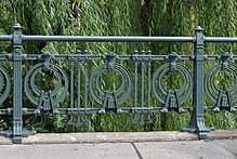
The difference in level between the quay and the river bed of the Danube Canal was originally overcome by a grassy embankment. In the course of the construction of the light rail, a brick, drivable front quay was built around 1900 (today a cycle route on the south bank ), on the level of which the track structure of the light rail was built, partly completely enclosed, partly in open galleries. This resulted in a paved bank edge at street level with the typical Otto Wagner railings , from which stairs and ramps at the bridges lead to the front quay. At the level of the fore quay and on the water upstream of the Salztorbrücke there was a fish market since 1875, some of which was still in use until the 1970s.
On the fore quay between Marienbrücke and Schwedenbrücke, the new, architecturally remarkable ship station Wien City was built on the edge of Schwedenplatz by 2010, from where the “Twin City Liner” runs to Pressburg according to schedule . Other boat tours also have their starting point here. A bathing ship is anchored in the Danube Canal between Schweden- and Aspernbrücke. The waterside edge of the pre-quay forms the border between the 1st and 2nd district .
Individual evidence
- ^ Wolfgang Kos, Christian Rapp : Alt-Wien. The city that never was , catalog of the 316th special exhibition of the Wien Museum in the Künstlerhaus , November 25, 2004–28. March 2005; Wien Museum, Czernin Verlag, Vienna 2004, ISBN 3-7076-0202-8 , p. 283
- ^ Felix Czeike : Historical Lexicon Vienna. Volume 2: De-Gy. Kremayr & Scheriau, Vienna 1993, ISBN 3-218-00544-2 , pp. 368-369.
- ↑ Vienna for 60 years. An album for the youth , Gerlach & Wiedling, Vienna 1908, p. 54 above
- ^ Felix Czeike : Historical Lexicon Vienna. Volume 3: Ha-La. Kremayr & Scheriau, Vienna 1994, ISBN 3-218-00545-0 , p. 152.
- ↑ Susanne Fritsch, Hannes Tauber: The fall of the bastion. The Viennese fortifications and their end in 1857 , Wiener Geschichtsblätter , supplement 3/2007, published by the Association for the History of the City of Vienna, Vienna 2007, ISSN 0043-5317 , p. 16
- ^ Walter Krobot, Josef Otto Slezak, Walter Sternhart: Tram in Vienna the day before yesterday and the day after tomorrow , Verlag Josef Otto Slezak, Vienna 1972, ISBN 3-900134-00-6 , p. 299 f.
- ^ Website of the ÖBB-Postbus GmbH - Morzinplatz / Schwedenplatz – Schwechat
- ^ Website of the Twin City Liner
Web links
Coordinates: 48 ° 12 '53.1 " N , 16 ° 22'25.2" E
