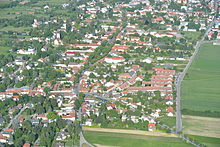
Stammersdorf
| Stammersdorf | |
|---|---|
| coat of arms | map |
 |

|
Stammersdorf is the last part of the 21st Viennese district Floridsdorf , which was incorporated into Vienna in 1938 . Today Stammersdorf is one of the 89 Viennese cadastral communities .
geography
Stammersdorf lies on the southeast slope of the Bisamberg and is crossed by the Marchfeld Canal , which was opened in 1992 . It borders in the north on Lower Austria , in the west on Strebersdorf , in the south on Großjedlersdorf and in the east on Leopoldau and is now divided into Oberort, Unterort and Neu-Stammersdorf. The Oberort is the oldest part of the settlement with the first traces of settlement around 2000 BC. The suburb arose with the growing importance of the Vienna - Brno transport axis , Brünner Strasse , and developed eastward to Brünner Strasse. Neu-Stammersdorf is the newest part and was only built in the 1990s.
history
The village on the slope of the Bisamberg towards the Marchfeld was first mentioned in a document in 1150, but it was probably created around 1100; it was originally called Stenmarsdorf or Stamleinsdorf , 1203 Stoumarsdorf . The place name is derived from the Slavic personal name Stojmir .
The village green , along which the main road connecting the upper and lower towns runs, stretches between the upper town and the lower town. Stammersdorf is therefore a so-called Linsenangerdorf. The village church, which can be reached from the Anger through a narrow lane, the Stammersdorf parish church , is one of the old fortified churches in Lower Austria; the place was defensible because the field, on which the cattle could graze if necessary, was surrounded by closed rows of houses. Nevertheless, one after another Hungarians, Turks, Swedes, again Turks and finally the French devastated the place.
Stammersdorf was also a popular field camp: The Bohemians under Count Thurn settled here in 1619 , and in 1645 the Swedish general Torstensson chose the area as his headquarters. In 1805 the Austrians moved into their field camp here and in 1866 a line of defense against the Prussians was planned at Stammersdorf. In the plague years 1679 and 1713 many residents perished; The greatest material damage, on the other hand, was caused by the fire in 1850 - in addition to warlike destruction: the church, 52 houses and 38 barns were destroyed. Despite everything, the settlement, which has grown over the centuries, has retained its village character to this day.
In the long-distance network it was under Emperor Charles VI. Not involved: Brünner Straße runs past the village to the east. The compound according to Wien was carried by the 1886 Augartenbrücke led out Dampftramway improved, the line was electrified 1912th After the First World War the “Freiwillige Rettungsgesellschaft Stammersdorf” was founded, the founder was Theodor Schimanek. The society was financed through donations. In 1928 Stammersdorf was raised to a market town, in the same year the streets were named. Stammersdorf has only been part of Vienna's 21st district since 1938.
During the Second World War , many anti-aircraft guns were stationed at nearby Bisamberg to protect Vienna from air raids. Four are still preserved in the ground plans - to be found on the old ski jumps . In this protected zone an aircraft factory was built on the edge of the Bisamberg, the remains of which can still be seen today. Today's Van Swieten barracks was built on Brünner Strasse between 1939 and 1940 . A second barracks - a tank workshop - was built in Gerasdorferstrasse. The ÖMV was on this site for a few years. However, the facilities were almost completely removed in 2012 and a large housing estate was built.

The new Stammersdorfer central cemetery was built from 1902 according to the plans of the engineer Oskar Mratschek and master builder Alois Frömmel and consecrated on May 27, 1903 by Dean Ludwig Hüttner von Pillichsdorf . From 1964 to 1966, the second Viennese crematorium was built there . However, it was closed again on September 7, 1981 and only temporarily put into operation again during the renovation of the Simmering fire hall from 1984 to 1986 .
nature
To the north of the village are the old entrenchments , former defensive structures and today remarkable natural monuments.
Economy and Infrastructure

Wine is grown on the slopes of the Bisamberg. With around 267 hectares of vineyards, Stammersdorf is one of the most important wine-growing areas in Vienna . The local Heurigen are a popular destination.
The Van Swieten barracks with the Army Hospital and the Army Medical School are located in Stammersdorf .
Personalities
- Karl Friedl (1884–1955), butcher, innkeeper and ÖVP politician
- Hermann Reschny (1898–1971), NSDAP politician and SA leader
literature
- Felix Czeike: Vienna XXI. Floridsdorf. Viennese district leader . J&V, Vienna 1979, ISBN 3-7141-6221-6 .
- Raimund Hinkel: Vienna XXI. Floridsdorf. The home book. Jedlsee, Schwarzlackenau, Strebersdorf, Jedlersdorf, Leopoldau, Stammersdorf, intermediate bridges, Donaufeld, Floridsdorf, Jedlersdorf am Spitz . Vienna 1994. ISBN 3-85447-528-4 .
- Günter Weber (Ed.): Stammersdorf - Strebersdorf 1890 - 1960 . Album Verlag für Photographie, Vienna 2000, ISBN 3-85164-092-6 .
- Peter Diem, Michael Göbl, Eva Saibel: The Viennese districts . 2nd edition 2003, Deuticke, ISBN 3-85223-463-8 .
- Franz Polly: Local history Stammersdorf . Vienna 1979.
Web links
- Historical and other information about Stammersdorf. In: Stammersdorf.at
Individual evidence
- ^ Felix Czeike, Historisches Lexikon Wien, Volume 5 RZ (Vienna 2004), p. 312.
- ↑ Friedhöfe Wien GmbH - History of the Stammersdorfer Zentralfriedhof ( page no longer available , search in web archives ) Info: The link was automatically marked as defective. Please check the link according to the instructions and then remove this notice. .
- ↑ Vineyards in Vienna according to cadastral communities 2010. Website of the City of Vienna, accessed on June 21, 2012.
Coordinates: 48 ° 18 ' N , 16 ° 26' E


