Marchfeld Canal

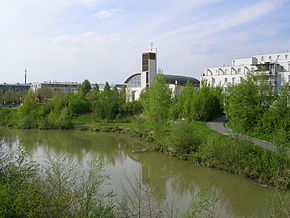
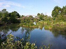
The Marchfeld Canal is an artificially constructed and naturally designed channel in Lower Austria and Vienna and floods the Rußbach with water from the Danube . The 18 kilometer long canal is, among other things, an important supplier of water for the Marchfeld vegetable farmers and a local recreation area.
geography
The Marchfeldkanal is long in the first flow direction 18 km long section of 80 kilometers and orographic left of the Danube running Marchfeldkanal system consisting Marchfeldkanal, Rußbach , Upper Siebenbrunner channel and Stempfelbach there.
In Langenzersdorf (Lower Austria) just before the wide sluice gates to the New Danube , water is diverted obliquely from the Danube on the left bank through horizontal slits and under the Danube bank accompanying path and the Danube bank motorway A22 over 2 parallel channels for the first 100 m . After a 2-channel inlet structure regulating the flow and water level, the Marchfeld Canal runs only 2 km in northeast, south-south-east (SSE), close to the motorway and thus parallel to the Danube. In the third kilometer, the Marchfeld Canal turns to ONO, widens in two lanes to form a sedimentation area that represents part of the former Black Lacquer . In this near-natural section, by slowing down the flow velocity, suspended matter from the mountain river Danube can settle. In winter when there is frost, this area is popular as a natural ice rink , especially since the possible depth of penetration in an emergency is a maximum of half a meter.
From here the canal runs in the general direction ONO, but on the next 7 km in Vienna it is repeatedly roughly angled to follow streets, on the last 9 km the March Canal flows again through Lower Austria, more straight and to the east, accompanying it last Coming from the left the narrow Seyringer ditch for 2 km, which joins shortly before the canal joins the Russbach, also coming from the left, to turn here as the Russbach to the SE.
In the 21st Viennese district of Floridsdorf , the Marchfeld Canal crosses the districts Jedlesee , Strebersdorf , Großjedlersdorf and Stammersdorf . Then it runs in Lower Austria via Gerasdorf in the Marchfeld to the Russbach near Deutsch Wagram. The Obersiebenbrunn Canal connects the Rußbach with the Stempfelbach.
history
The Marchfeld northeast of Vienna is an intensely agricultural area. The region suffers from a lack of water due to low rainfall and high levels of groundwater being withdrawn for irrigation purposes . The first ideas for large-scale field irrigation in the Marchfeld emerged as early as 1850.
As a result of the overexploitation of the groundwater body (there were around 5,000 wells in 1985) and its increasing impairment due to the input of substances such as nitrate , the authorities issued water restrictions and time limits for the abstraction of irrigation. As a result of the regulation of the Danube , the groundwater level fell steadily. In 1983 alone it sank by half a meter.
The planning was carried out according to both ecological and military aspects. The latter were taken into account by measures to defend against enemy tanks . Iron rings are embedded in the bridge foundations, to which chains with armored hedgehogs can be attached in an emergency . Furthermore, the embankments are deliberately designed in such a way that one side has a steep, but the other has a flat rise, which meant that the cannon barrels of the attacking tanks should get stuck in the embankment.
Construction work on the Marchfeld Canal began in 1984. In 1992 it was put into operation. The operating company Marchfeldkanal is located in Deutsch Wagram .
use
The Marchfeld Canal provides water for agricultural irrigation, for which numerous water cooperatives were founded. Another aim is to stabilize and improve the hydrological conditions through a planned enrichment of the groundwater. For the flora and fauna it is to the water quality improve the groundwater and the Oberflächengerinne. A total of twelve sewage treatment plants discharge their wastewater into the Rußbach and Stempfelbach, whereby the water flow of the receiving waters is reinforced by the canal.
The canal also ensures improved flood protection . During the Danube flood in 2002 , damage like the last similar flood in 1954 could be avoided.
The Marchfeld Canal is also a local recreation area. With accompanying cycle paths, it offers leisure opportunities for the residential area. Bathing is prohibited in the entire area. However, the canal can be navigated by boats without a motor.
Technical specifications
| Sections of the canal system: | length |
|---|---|
| Marchfeld Canal | 19 km |
| Russbach | 39 km |
| Obensiebenbrunnerkanal | 6 km |
| Stempfelbach | 24 km |
| Structural systems | number |
|---|---|
| Infiltration systems | 3 |
| New bridges | 45 |
| Weir systems | 8th |
| Pumping stations (flood protection) | 5 |
| Control and monitoring devices | |
| Flood warning stations | 4th |
| Online quality measuring points | 3 |
| Automatic level systems | 45 |
| Automatic water level measuring points | 205 |
| Groundwater quality measuring points | 70 |
literature
- Hannes Batik, Christiane Breznik: Marchfeld Canal in Floridsdorf - information, public, planning . Institute for Landscaping and Horticulture at the University of Natural Resources and Life Sciences, Vienna 1992.
- Heinz Kaupa, Wolfgang Neudorfer: Cost-benefit study for the Marchfeld Canal System . Errichtungsgesellschaft Marchfeldkanal, Deutsch Wagram 1993, ISBN 3-900827-12-5 .
- Werner Pöll: Recreational and leisure use on the Marchfeld Canal - usage claims, usage conflicts, control measures . Diploma thesis, University of Natural Resources and Life Sciences, Vienna 1994.
Individual evidence
- ^ Heer uses Marchfeld Canal: Ökoprojekt und Panzerfalle [Arbeiterzeitung] Print, July 31, 1987, p. 15, accessed February 7, 2017.
- ↑ a b c The Marchfeld Canal Cycle Route (PDF; 661 kB) accessed on May 14, 2010
Web links
- Operating company Marchfeldkanal
- Entry on Marchfeld Canal in the Austria Forum (in the AEIOU Austria Lexicon )
Coordinates: 48 ° 18 ′ 16 ″ N , 16 ° 26 ′ 51 ″ E


