Deutsch-Wagram
|
Borough Deutsch-Wagram
|
||
|---|---|---|
| coat of arms | Austria map | |
|
|
||
| Basic data | ||
| Country: | Austria | |
| State : | Lower Austria | |
| Political District : | Gänserndorf | |
| License plate : | GF | |
| Surface: | 30.62 km² | |
| Coordinates : | 48 ° 18 ' N , 16 ° 34' E | |
| Height : | 159 m above sea level A. | |
| Residents : | 8,960 (January 1, 2020) | |
| Population density : | 293 inhabitants per km² | |
| Postal code : | 2232 | |
| Area code : | 02247 | |
| Community code : | 3 08 08 | |
| NUTS region | AT126 | |
| Address of the municipal administration: |
Bahnhofstrasse 1 2232 Deutsch-Wagram |
|
| Website: | ||
| politics | ||
| Mayor : | Friedrich Quirgst ( ÖVP ) | |
|
Municipal Council : (Election year: 2020 ) (33 members) |
||
| Location of Deutsch-Wagram in the Gänserndorf district | ||
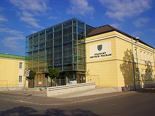
 town hall |
||
| Source: Municipal data from Statistics Austria | ||
Deutsch-Wagram is a municipality with 8960 inhabitants (as of January 1, 2020) in the Gänserndorf district in Lower Austria .
geography
Deutsch-Wagram is located directly on the northeastern city limits of Vienna , the northern railway and the outer ring expressway .
The area of the municipality covers 30.61 km². 17.62 km² of this is used for agriculture. 5.7 percent of the area is forested.
Urban division
- Deutsch-Wagram (with the old Angerdorf and with Hagerfeld ; the KG is written Deutsch Wagram )
- Helmahof (with the 3rd settlement)
- Stallingerfeld (uninhabited, named after the village of Stallern, which was deserted in 1512)
The municipality forms a single locality and has four counting districts : Deutsch-Wagram-Zentrum and Südost for the city itself and Helmahof-Süd and -Nord .
Deutsch-Wagram belongs to the Gänserndorf judicial district .
Neighboring communities
|
Pillichsdorf Gerasdorf |
Grossengersdorf | Bockfließ |
| Vienna |

|
Strasshof on the northern line |
| Aderklaa | Raasdorf |
Markgrafneusiedl Parbasdorf |
Waters
- Russbach
- Mühlbach
- Seyringer Ditch (Seyringer Bach)
- Marchfeld Canal : The groundwater level in Marchfeld has been falling for decades. As early as the 19th century, considerations were being made as to how this problem could be countered. In 1986 the construction of a canal began to enrich the groundwater with Danube water . In 1995 the main channel between Langenzersdorf and Deutsch-Wagram was completed. Since then, the Marchfeld Canal system has included the Marchfeld Canal , the Rußbach, the Obersiebenbrunn Canal and the Stempfelbach . The Marchfeld Canal operating company is based in Deutsch-Wagram.
climate
|
Average monthly temperatures and precipitation for Deutsch-Wagram
Source: Bergauer weather station
|
|||||||||||||||||||||||||||||||||||||||||||||||||||||||||||||||||||||||||||||||||||||||||||||||||||||||||||||||||||||||||||||||||||||||||||||||||||||||||||||||||||||||||||||||||||||||||||||||||||||||||||||||||||||||||||||||||
history
etymology
The name Wagram is derived from wac 'wave' and ram / rain 'limit' ("wave limit"). What is meant by this is probably the terrain that runs south along Parbasdorferstraße and formed the bank of a now gone arm of the Danube (similar to the ridge called Wagram near Krems, 50 kilometers away ). The first written mention of the name comes from the time of the Austrian interregnum under King Ottokar II and can be found in the Rationarium Austriacum created in 1258 , a tithe directory of the sovereign. The addition German was given to Wagram around 1560 to distinguish it from the nearby Croatian Wagram , a Croatian settlement that was created after the Turkish invasion of 1529 , which is now called Wagram on the Danube and was incorporated by Eckartsau in 1971 .
origin
The origins of Wagram probably go back to the time of colonization in the 11th and 12th centuries. The former colonist village had the typical shape of a rural village, which is still there today. The Anger is enclosed by today's Franz-Mair-Straße and Rohrergasse, but was partially built in in the 19th century. The size of the old town has hardly changed over the centuries (1258: 44 houses, 1452: 44 houses, 1590: 46 houses, 1595: 47 houses). Until 1787, some other professions such as butcher, shoemaker, baker, weaver and tailor joined the originally purely rural population and the number of houses rose slightly to 58.
The Russbach flowed through the village green , which was a very dangerous brook until it was finally regulated. The old Wagramer therefore made water boards that fit into the door frames of the houses and were reinforced with sandbags. Nevertheless, one often had to take refuge on the higher Haide. In 1772 the Russbach was diverted and has been flowing southwest of the village ever since. The threat to the place was only eliminated by the regulation in the years 1899–90 and 1908/09.
Rulership
Originally owned by the rulers , the village was owned by the Lords of Eckartsau in the 14th and 15th centuries , and by the Lords of Puchaim in the 15th and first half of the 16th centuries . Around 1560, Barbara von Puchaim brought Wagram into the marriage with Count Sigmund von Landau, who united it with the Süßenbrunn rulership . After the Counts of Landau professed Protestantism in 1580, a short Protestant period follows in Wagram. When Georg and Erasmus von Landau went so far as to refuse to pay homage to Emperor Ferdinand II , they were subsequently ostracized, their goods were confiscated and placed under the administration of the court chamber and they themselves were expelled from the country. From 1667 to 1802 the Counts Grundemann von Falkenberg exercised the manorial rule over Deutsch Wagram.
Coalition wars
The place gained historical importance in 1809 as the site of the Battle of Wagram . 180,000 soldiers fought here on the French side under Napoleon and 120,000 on the Austrian side under the Generalissimo Archduke Karl , who took his headquarters in today's Archduke Carl House.
railroad

In 1835 Wagram still consisted of 73 houses. This changed rapidly with the construction of the Kaiser Ferdinands-Nordbahn , the first steam-powered railway line in Austria. On the one hand 1,500 railway workers were housed in numerous barracks near Wagram, on the other hand the railway line opened up the village for the big city and Wagram became a popular excursion destination for the Viennese. Within a few months, 176,000 people drove on the new first section between Floridsdorf and Deutsch-Wagram, which opened on November 23, 1837 .
19th and 20th centuries
In 1929, Wagram was the largest town in the Marchfeld with 4000 inhabitants and was raised to the rank of a market town . In the same year a lido was opened, which however had to be closed again a few years later due to the lower groundwater level.
In May 1945, a large contingent of Soviet occupation troops was stationed in Deutsch-Wagram because of the nearby military airfield. The post-war period was determined by coexistence with the Russians.
The rest of the post-war period was characterized by strong population growth. In 1962, the express train was put into operation as a feeder line to Vienna. This made it even more attractive for commuters. With further population growth, Deutsch-Wagram was elevated to a city in 1984 .
Population development

The population development of Deutsch-Wagram is characterized by strong growth, which is due to a positive immigration balance. The birth balance was negative until 2005 and has been slightly positive since 2006 (0.1%). The move is due to the good transport connections to Vienna ( Speckgürtel ).
The population of Wagram is characterized by the influx of young families. Therefore, the proportion of over 60-year-olds at 18.8% is significantly lower than in Vienna. Accordingly, the proportion of under 15-year-olds is higher at 18.6% (cf. Vienna 14.7%). The university graduates is 5.6%, well below that of Vienna (10.4%).
Origin and language
92.9% of Austrians live in Deutsch-Wagram. The largest group of foreigners are citizens of Serbia and Montenegro with 2.5%, followed by Turks (0.9%) and Germans (0.7%). Colloquial language is 89.2% German, followed by Serbian (2.7%) and Turkish (1.3%).
Religions
The largest religious community is the Roman Catholic Church , to which 66.1% of the population belong. 3.0% are Protestant, 2.8% each profess to the Orthodox Church and Islam. 21.8% of the population are without religious beliefs.
Deutsch-Wagram is the seat of the Roman Catholic parish Deutsch-Wagram, which also includes the neighboring villages of Parbasdorf and Aderklaa and is assigned to the Deanery Gänserndorf. Deutsch-Wagram was a parish even before the 16th century, initially as a branch of Kagran. Because of the great distance she came to the parish of Gerasdorf in 1640. On March 22, 1784 Deutsch-Wagram was raised to an independent parish. With the elevation of Deutsch-Wagram to the city in 1984, the church was elevated to the city parish church. The patron saint is John the Baptist .
coat of arms
The official description is:
- A shield divided from yellow to blue on the left , covered with a green ear of wheat growing up out of a lawn , accompanied on the right by a silver plow knife and on the left by a silver ploughshare .
The Wagramer coat of arms was first used in 1810 to affirm a tenth lease agreement with the Süßenbrunn rulership.
Community partnerships
- since ? Calheta de São Miguel ( Cape Verde )

- since ? Gbely ( Slovakia )

politics
The municipal council has 33 members.
- With the municipal council elections in Lower Austria in 1990, the municipal council had the following distribution: 18 SPÖ, 8 ÖVP, 2 FPÖ and 1 alternative citizens' list.
- With the municipal council elections in Lower Austria in 1995, the municipal council had the following distribution: 14 SPÖ, 6 ÖVP, 5 FPÖ, 3 Greens and 1 LIF.
- With the municipal council elections in Lower Austria in 2000, the municipal council had the following distribution: 16 SPÖ, 7 ÖVP, 3 Greens and 3 FPÖ.
- With the municipal council elections in Lower Austria in 2005 , the municipal council had the following distribution: 12 ÖVP, 12 SPÖ and 5 Greens.
- With the municipal elections in Lower Austria in 2010 , the municipal council had the following distribution: 16 ÖVP, 8 SPÖ, 3! We, 1 FPÖ and 1 Greens. (29 members)
- With the municipal council elections in Lower Austria in 2015 , the municipal council had the following distribution: 19 ÖVP, 6 SPÖ, 4! We, 2 Greens and 2 FPÖ.
- With the municipal council elections in Lower Austria 2020 , the municipal council has the following distribution: 17 ÖVP, 7 SPÖ, 4! We, 3 Greens and 2 FPÖ.
- mayor
- 1850–1860: Josef Wieland
- 1860–1864: Franz Wald
- 1864–1867: Franz Quirgst
- 1867–1876: Ferdinand Hager
- 1876–1879: Franz Mayer
- 1879–1888: Franz Schlederer
- 1888–1902: Anton Quirgst
- 1902–1908: Michael Wieland
- 1909-1914: Ferdinand Leeb
- 1914–1919: Franz Wieland
- 1919–1922: Leopold Bauer
- 1922–1924: Franz Deussner
- 1924–1928: Paul Schilder
- 1928–1930: Heinrich Widmayer
- 1930–1934: Anton Poppe
- 1934–1938: Heinrich Widmayer
- 1938–1945: Gustav Hettinger (1939–1944 military service)
- 1939–1941: Rudolf Puchner
- 1941–1944: Josef Emmerich Simkovics
- 1944–1945: Gustav Hettinger
- 1945–1962: Karl Stibernitz (SPÖ)
- 1962–1982: Otto Hübner (SPÖ)
- 1982–1998: Hans Muzik (SPÖ)
- 1998–2001: Rudolf Melzer (SPÖ)
- 2001-2005: Walter Wimberger (SPÖ)
- since 2005: Friedrich Quirgst (ÖVP)
Main town of the municipality: City of Deutsch-Wagram
|
Deutsch-Wagram ( city ) cadastral municipality Deutsch Wagram |
|
|---|---|
| Basic data | |
| Pole. District , state | Gänserndorf (GF), Lower Austria |
| Pole. local community | Deutsch-Wagram |
| Locality | Deutsch-Wagram |
| Coordinates | 48 ° 17 ′ 49 " N , 16 ° 33 ′ 26" E |
| height | 159 m above sea level A. |
| Residents of the stat. An H. | 3093 (2001) |
| Building status | 1192 (2001) |
| Area d. KG | 17.25 km² |
| Post Code | 2232 Deutsch-Wagram |
| Statistical identification | |
| Cadastral parish number | 06031 |
| Counting district / district | Deutsch-Wagram-Zentrum, Deutsch-Wagram-Südost (30808 000,001) |
| EW / building with Hagerfeld Source: STAT : Local directory ; BEV : GEONAM ; NÖGIS |
|
The capital of the municipality is the city of Deutsch-Wagram , which also forms a cadastral municipality of the municipality.
The place is located about 15 kilometers northeast of the center of Vienna , 3½ kilometers outside the city limits near Süßenbrunn . The city is located south of the northern runway from Russbach eastwards to around 160 m above sea level. A. Height. It comprises around 1200 buildings with a good 3000 inhabitants (45% of the community population), so the Helmahof settlement is now larger. Historically, the place has expanded away from the Russbachufer.
The cadastral municipality of Deutsch Wagram with 1,724.7 hectares (around 3 ⁄ 4 of the municipal area) also includes the corridors in the northwest, south and east of the municipality.
|
Pillichsdorf
Reuhof (KG) |
Helmahof
(O and KG) |
Wendlingerhof ∗ (KG, Gem.Bockfließ , District Mistelbach ) |
|
Stallingerfeld |

|
|
|
Aderklaa (KG, Gem.) |
Raasdorf (KG, Gem.) |
Parbasdorf (KG, Gem.) |
- ∗KG Wendlingerhof only borders in one point, Kapellerfeld only a small part
- ∗∗The place Markgrafneusiedl itself lies southeast behind Parbasdorf
Culture and sights
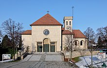
- Catholic parish church Deutsch-Wagram hl. John the Baptist: The church was built as a fortified church on a hill in the old village of Anger. It is surrounded by a defensive wall, the end of which is no longer preserved. The bastions from 1671 are still visible today. The original Romanesque nave with a choir square was built in the first half of the 13th century, the Gothic choir and nave were built in the second half of the 15th century. In 1671 the church was baroque and expanded to the west. In the years 1956-1958 the church was significantly expanded and expanded to a capacity of 1000 people. The axis of the new church is at right angles to the axis of the old church, whereby the transept of the new church corresponds to the demolished nave of the old church.
- Monumental chapel: The first memorial to the war year 1809 is located at the former cemetery, today's Sahulkapark. It was built by Hugo v. Tkalcsevich - the son of an officer who fell in the battle of Wagram - and served as the family crypt.
- Deutsch-Wagram local history museum with Napoleon Museum in a listed town house
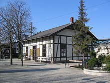
- Railway museum at Deutsch Wagram station in the old workers' waiting room at the station
economy
There were 260 non-agricultural workplaces in 2001, and agricultural and forestry holdings according to the 1999 survey 27.
According to the 2001 census, the number of people in employment at their place of residence was 3,164, while 2,591 people commuted, almost 2,000 of them to Vienna. The employment rate in 2001 was 47.94 percent.
- Companies
- Glock : manufacturer of handguns since 1963, which pays almost a quarter of the local municipal tax.
traffic
Deutsch-Wagram is connected to Vienna by the B8 Angerner Straße as well as to the district capital Gänserndorf . Here the L6 crosses Leopoldsdorf - Paasdorf , the L13 leads via Helmahof to Bockfließ (L12 to Gänserndorf). The L3019 leads south to Raasdorf , the L3023 passes Aderklaa (B8) - Parbasdorf (L6).
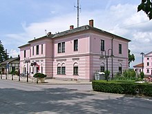
The northern railway also connects with Vienna and Gänserndorf. In the village there are two train stations at Deutsch Wagram station , which was only called Wagram in 1908 , at kilometer 18.2 of the northern railway and the Helmahof station at 20.8 kilometer. There are half-hourly S-Bahn connections to Vienna and Gänserndorf on the S1 . With the main platform (1) and the central platform (2/3), the station has two platforms and three platform edges. Regional buses stop at the station forecourt .
A city bus from the StadtBus - Deutsch-Wagram association has been operating in the local area since November 2012 . The ride is only allowed as a club member.
As part of the regional ring, the S8 Marchfeld expressway will run south of the town , with a Deutsch-Wagram junction to the extended S1 Wiener Außenring Schnellstraße south of Aderklaa and a junction to the L6 near Parbasdorf and the Strasshof junction on the eastern edge of the community. These extensions are so far only in the planning stage.
education
- School center Deutsch-Wagram : In addition to an elementary school and a secondary school / middle school, Deutsch-Wagram has been home to an upper-level secondary school ( BORG Deutsch-Wagram ) with a focus on instrumental lessons, artistic design and handicrafts or sport, which was run as a privatehighschool of the municipality until August 2011. At the same time, the school was able to move into a modern and technically up-to-date building.
- The adult education center offers regular courses.
- There is also a music school ( MS Deutsch-Wagram ) in Wagram .
- The Lower Austrian State Academy maintains the Lower Austrian Language Competence Center in Deutsch-Wagram , which acts as an information hub and service point for language services in the Czech and Slovak languages.
fire Department
Since 1883 there has also been a volunteer fire brigade in Deutsch-Wagram. This has been housed in Jakob Grünwald-Gasse 2 in the new fire station since 1996. Currently (as of February 2014) 90 people are employed by the fire brigade. In addition to an annual fire brigade festival in June, there are regular events such as the blood donation campaign (quarterly), the blue light day in cooperation with the police and ambulance, the extinguishing demonstrations and the peace light at Christmas.
The fire brigade's commanding officer is currently chief fire inspector Wolfgang Süß sen., His deputy is chief fire inspector Christian Schantl and the administration is handled by head administrator Walter Süß. Every year there are around 200 missions in the municipality and the surrounding municipalities.
Sports
- Soccer: There are 2 soccer fields in the local area. One square is part of the school sports grounds on Franz-Schubert-Straße. The second place (stadium) is in the so-called Spartawald on Angernerstrasse. The facility has a grandstand and a canteen building with sanitary facilities. It is used by ATSV Sparta, founded in 1923. The club's combat team currently plays in 1st class north.
- Tennis: The Deutsch-Wagram tennis club, founded in 1964, has 6 clay courts and 2 indoor courts. These were built in the 1960s on the site of the former lido. The club can boast a number of sporting successes. The team played in the top division for several seasons.
Personalities


- Honorary citizen
- Johann Faimann (1881), station director dkk Ferd.Nordbahn
- Johann Mayer (1907), Governor of Lower Austria
- Johann Heilinger (1911), entrepreneur
- Ottokar Weyrich (1915), school director
- Eduard Erb-Rudtorfer (1915), district captain
- Josef Kirschner (1923), director of the I. Railway Car Hire Company
- Karl Buresch (1928), Governor, Federal Chancellor
- Franz Krischke (1930), primary school director
- Karl Renner (1930), Federal President
- Paul Schilder (1931), Mayor
- Ferdinand Pečka (1933), dean and pastor
- Alois Hofbauer (1933), Vice Mayor
- Norbert Kienzl (1938), community doctor
- Franz Wieland (1952), district fire brigade commander, founder of the warehouse cooperative
- Karl Wiesinger (1958), principal school director
- Karl Stibernitz (1962), Mayor
- Otto Hübner (1999), Mayor
- Hans Muzik (1999), Mayor, Member of the State Parliament
- Josef Bonet (2008), pastor
- Gerhard Bocek (2020), innkeeper
- Personalities who were born in Deutsch-Wagram
- Johann Sahulka (1857–1927), scientist
- Johann Mayer (1858–1941), miller, politician and governor of Lower Austria
- Anton Pfalz (1885–1958), linguist
- Thomas Forstner (* 1969), musician
- Personalities who are / were connected to the city
- Jürgen Melzer (* 1981), tennis player
- Gerald Melzer (* 1990), tennis player
- Günter Haiden (1926–2004), Federal Minister
- Gaston Glock (* 1929), manufacturer
- Leopold Grausam jun. (1946–2010), sculptor and master stonemason
- Norbert Schnedl (* 1960), trade unionist
- Gabriela Hegedüs (* 1975), actress
literature
- Manfred Groß: Moving history self-published by the community, Deutsch-Wagram 2009, ISBN 978-3-200-01592-0 .
- Anton Pfalz: History of the local community Deutsch-Wagram. 1912.
- Gerhard Radvan: 200 years of Deutsch-Wagram Volume 1. Self-published by the municipality, Deutsch-Wagram 1994.
- Otto Schilder: Deutsch-Wagram present and past. Self-published by the municipality, 1979.
- Otto Schilder: Deutsch-Wagram From the Angerdorf to the municipality. Commerce, trade and industry Deutsch-Wagram, 1984.
Web links
- Community website
- Entry on Deutsch-Wagram in the Austria Forum (in the AEIOU Austria Lexicon )
- 30808 - Deutsch-Wagram. Community data, Statistics Austria .
- Website of the local history museum and the battle of Wagram 1809 in the Archduke Carl Haus
Individual evidence
- ↑ Statistical Yearbook
- ^ A b Office of the Lower Austrian Provincial Government Zl. LA. MM / 3-a-124 of April 26, 1958.
- ^ Result of the municipal council election 1995 in Deutsch-Wagram. Office of the Lower Austrian State Government, March 30, 2000, accessed on February 28, 2020 .
- ^ Election result of the municipal council election 2000 in Deutsch-Wagram. Office of the Lower Austrian State Government, February 4, 2005, accessed on February 28, 2020 .
- ^ Election result of the municipal council election 2005 in Deutsch-Wagram. Office of the Lower Austrian State Government, March 4, 2005, accessed on February 28, 2020 .
- ^ Election result of the municipal council election 2010 in Deutsch-Wagram. Office of the Lower Austrian State Government, October 8, 2010, accessed on February 28, 2020 .
- ^ Election result of the 2015 municipal council election in Deutsch-Wagram. Office of the Lower Austrian State Government, December 1, 2015, accessed on February 28, 2020 .
- ↑ Results of the municipal council election 2020 in Deutsch-Wagram. Office of the Lower Austrian State Government, January 26, 2020, accessed on February 28, 2020 .
- ↑ Nominally, the capital of the municipality is a locality, i.e. the entire municipality here.
- ↑ a b see Grademap sheet Zone 12 Colonne XV Section c4 (later 4657-3d). Marchfeld: Süssenbrunn, Gerasdorf, Deutsch Wagram, Breitenlee, Aderklaa. Francisco-Josephine (3rd) land survey of the Austro-Hungarian monarchy. Recording sheet 1: 12,500. Recorded in 1873 (file on Commons, top right).
- ↑ Bundesdenkmalamt (Ed.): DEHIO-Handbuch Die Kunstdenkmäler Österreichs - Lower Austria north of the Danube , Vienna 1990, p. 92
- ↑ mysterious Glock factory in Deutsch Wagram , welt.de, accessed on May 29, 2015
- ↑ Association StadtBus Deutsch-Wagram ( page no longer available , search in web archives ) Info: The link was automatically marked as defective. Please check the link according to the instructions and then remove this notice.
- ^ Website of the volunteer fire brigade Deutsch-Wagram
- ^ The honorary citizens of Deutsch-Wagram, handwriting, 1930 – today
- ↑ https://www.mein Bezirk.at/gaenserndorf/c-lokales/spargelkoenig-bocek-zum-ehrenbuerger-ernannt_a3883884 , accessed on June 12, 2020.


