
Dürnkrut
|
market community Dürnkrut
|
||
|---|---|---|
| coat of arms | Austria map | |
 |
|
|
| Basic data | ||
| Country: | Austria | |
| State : | Lower Austria | |
| Political District : | Gänserndorf | |
| License plate : | GF | |
| Surface: | 30.39 km² | |
| Coordinates : | 48 ° 28 ' N , 16 ° 51' E | |
| Height : | 161 m above sea level A. | |
| Residents : | 2,237 (January 1, 2020) | |
| Population density : | 74 inhabitants per km² | |
| Postal code : | 2263 | |
| Area code : | 02538 | |
| Community code : | 3 08 11 | |
| NUTS region | AT125 | |
| Address of the municipal administration: |
Schloßplatz 1 2263 Dürnkrut |
|
| Website: | ||
| politics | ||
| Mayor : | Herbert Bauch ( SPÖ ) | |
|
Municipal Council : ( 2020 ) (21 members) |
||
| Location of Dürnkrut in the Gänserndorf district | ||
  |
||
.JPG) Dürnkrut Castle , municipal office |
||
| Source: Municipal data from Statistics Austria | ||

Dürnkrut is a market town with 2237 inhabitants (as of January 1, 2020) in the Gänserndorf district in Lower Austria .
The place is best known for a historical battle in the summer of 1278 between the Bohemian king Ottokar and the Habsburg Rudolf I , and for a former large sugar factory that is now used to produce other foods.
geography
Dürnkrut is located on the eastern edge of the Weinviertel on the March and thus on the border with Slovakia . The area of the market town covers 30.4 km². 5.55 percent of the area is forested.
Community structure
The municipality includes the following two localities (population in brackets as of January 1, 2020):
- Dürnkrut (1733)
- Waidendorf (504)
The community consists of the cadastral communities Dürnkrut and Waidendorf.
Neighboring communities
| Zistersdorf | Drösing , Jedenspeigen | |
| Velm-Götzendorf |
.svg)
|
Gajary |
| Ebenthal | Angern on the March |
history
- Dürnkrut
There are already finds from the Stone Age . These tools are made by Homo erectus and are around 800,000 years old and are exhibited in the museum in Dürnkrut.
Around 1045 Dürnkrut and its castle were created as a border settlement. Dürnkrut is mentioned in a document for the first time in a property register of the Hochstift Freising from 1160 . The Battle of Dürnkrut and Jedenspeigen on August 26th, 1278 between the Bohemian King Ottokar II. Przemysl and the Habsburg Rudolf I is considered the second largest knight battle in history after the Battle of Hastings . It ended with the victory of the Habsburgs, Ottokar II was slain while trying to escape.
The Vorwerk Ebersdorfer Hof protected Dürnkrut until the 15th century.
In April 2006 a dam broke in the course of the Thaya-March floods in 2006 . After that the place was flooded, causing catastrophic damage.
- Waidendorf
Waidendorf is located approx. 2 km south of Dürnkrut along the state roads 11 and 17. Waidendorf has belonged to the municipality of Dürnkrut since 1970, which was then decided by vote. In 1952, today's street names were introduced. Waidendorf is located at the eastern end of the Sulzbach valley and has an area of 10.67 km². The history of the place is very similar to that of Dürnkrut, as the two villages are close to each other. The place was founded at the time of the German conquest in the years 1040 to 1050.
Waidendorf's complex as a street village also suggests a medieval foundation. It was first mentioned in a document in 1250. In 1369, Waidendorf von Alber von Ottenstein came into the possession of Otto von Zelking , in 1376 from Otto von Zelking to his cousin Heinrich von Zelking, who sold it to Heinrich von Pottendorf in 1385. In 1423 Georg von Dachsberg handed Waidendorf over to the rule of the owners of Wolkersdorf.
In 1583, Waidendorf came into the possession of Baron Sigmund von Landau, who also held the dominions of Dürnkrut, Süssenbrunn, Ebenthal, Rodaun and Höflein. Although the Landau family, as Protestants, had to surrender their entire property to the imperial court chamber in 1621, Waidendorf remained in the possession of the respective Dürnkuter rule.
Under Emperor Joseph II , Waidendorf became an independent parish in 1783. According to the government decree, the two places of today's Velm-Götzendorf municipality were assigned to the Waidendorf parish.
A cholera epidemic in 1842 and 1855 killed 60 people, including 11 children. On November 24, 1878, a new school was opened, which today serves as a kindergarten and is located on Waidendorferhauptstrasse. The Waidendorf volunteer fire brigade was founded in 1886 and still has its fire station at Sulzbach today.
The census of 1934 showed 823 inhabitants, the cattle census also carried out produced 93 horses, 417 cattle, 480 pigs and 230 goats. At the last census in 2001, Waidendorf only had 532 inhabitants.
Population development
| census | Residents |
|---|---|
| 2011 | 2,257 |
| 2001 | 2,220 |
| 1991 | 2.164 |
| 1981 | 2,256 |
| 1971 | 2,592 |
Source: Dürnkrut population development. (PDF) Statistics Austria Dürnkrut had the largest population in 1951 with 2,802 inhabitants.
politics
The municipal council has 21 members.
- With the municipal council elections in Lower Austria in 1990, the municipal council had the following distribution: 13 SPÖ, 6 ÖVP and 2 ÜBL - non-partisan citizens' list.
- With the municipal council elections in Lower Austria in 1995, the municipal council had the following distribution: 12 SPÖ, 7 ÖVP, 1 ÜBL – non-partisan citizens' list and 1 FPÖ.
- With the municipal council elections in Lower Austria in 2000, the municipal council had the following distribution: 13 SPÖ, 7 ÖVP and 1 FPÖ.
- With the municipal council elections in Lower Austria in 2005 , the municipal council had the following distribution: 14 SPÖ and 7 ÖVP.
- With the municipal elections in Lower Austria in 2010 , the municipal council had the following distribution: 12 SPÖ, 8 ÖVP and 1 FPÖ.
- With the municipal council elections in Lower Austria in 2015 , the municipal council had the following distribution: 14 SPÖ, 6 ÖVP and 1 FPÖ.
- With the municipal council elections in Lower Austria 2020 , the municipal council has the following distribution: 14 SPÖ, 6 ÖVP and 1 FPÖ.
- mayor
- 1966–1988 Ludwig Huber sen. (SPÖ), honorary citizen of the market town of Dürnkrut
- 1988–1991 Willibald Seidl (SPÖ)
- 1991–2010 Rudolf Reckendorfer (SPÖ)
- since 2010 Herbert Bauch (SPÖ)
Culture and sights


- Primeval settlement of Buhuberg
- Dürnkrut Castle : The two-storey renaissance building with the gate tower that characterizes the townscape has a partially preserved Meierhof.
- Catholic parish church Dürnkrut hl. James the Elder: The unified baroque building with a western tower was erected under Count Jakob Hamilton in 1698.
- Catholic parish church Waidendorf hl. Ulrich
economy
In 2001 there were 71 non-agricultural workplaces, agricultural and forestry operations 46 according to the 1999 survey. According to the 2001 census, the number of people in employment at home was 978. In 2001, the activity rate was 45.17 percent.
A large sugar factory existed until around 1977, but it was closed a few years after the merger with 2 other Lower Austrian factories. This reduced the number of jobs, and the systems could only be partially re-used.
Today the larger companies include:
- the Instantina Food Factory (instant beverage powder, dextrose compressed, syrup)
- the Raiffeisen warehouse
- the Großmühle Hoffmann Leopold KG
- the plumber and roofing shop Pöll
- the trading company Billa
- Erste-Bank and Raiffeisenbank
- Two construction companies, electrical and transport companies
- There are also four doctors and a pharmacy in the village.
The community belongs to the RV March-Thaya-Auen .
traffic
- Train: Dürnkrut is located on the northern railway and thus has a good connection to Vienna . There is an ÖBB train between Břeclav or Bernhardsthal and Vienna and vice versa almost every hour .
- Street: Bernstein Strasse B49 from Angern - Hohenau - Mistelbacher Strasse B40 from Zistersdorf - Landesstrasse 11 or 17 to Waidendorf
- Bus: There is a bus connection between Mistelbach and Dürnkrut and between Gänserndorf and Dürnkrut.
education
- kindergarten
- Elementary school
- New middle school with a musical focus
Historical maps
- Dürnkrut in the regional survey around 1873

Dürnkrut (military accommodation for a maximum of 3000 men and 250 horses, far right) and the March around 1873
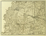
The March plain east of Dürnkrut could be reached directly over the bridge to Gayring

Waidendorf and the municipality of Velm-Götzendorf are to the west of Dürnkrut


Web links
- 30811 - Dürnkrut. Community data, Statistics Austria .
- Entry on Dürnkrut in the database of the state's memory for the history of Lower Austria ( Museum Niederösterreich )
- Website of the municipality (see also economy, history)
Individual evidence
- ↑ Statistics Austria: Population on January 1st, 2020 by locality (area status on January 1st, 2020) , ( CSV )
- ^ Archaeologia Austriaca - Volume 88/2004, 9–29 / 2006
- ↑ Karel Valoch: New old Paleolithic sites in N.Ö. Niederösterreichisches Landesmuseum 9-231-245, Vienna 1996, Archaeologia - Austriaca, Volume 88 2004.
- ^ Result of the local council election 1995 in Dürnkrut. Office of the Lower Austrian State Government, March 30, 2000, accessed on March 6, 2020 .
- ^ Election result of the municipal council election 2000 in Dürnkrut. Office of the Lower Austrian State Government, February 4, 2005, accessed on March 6, 2020 .
- ^ Election result of the municipal council election 2005 in Dürnkrut. Office of the Lower Austrian State Government, March 4, 2005, accessed on March 6, 2020 .
- ^ Election result of the municipal council election 2010 in Dürnkrut. Office of the Lower Austrian State Government, October 8, 2010, accessed on March 6, 2020 .
- ^ Election results for the 2015 municipal council elections in Dürnkrut. Office of the Lower Austrian State Government, December 1, 2015, accessed on March 6, 2020 .
- ↑ Results of the municipal council elections 2020 in Dürnkrut. Office of the Lower Austrian State Government, January 26, 2020, accessed on March 6, 2020 .
- ↑ a b https://www.duernkrut.gv.at/app.php/start.html
- ↑ The district mourns Mayor Rudolf Reckendorfer from Dürnkrut SPO district Gänserndorf, October 18, 2010.

Aderklaa | Andlersdorf | Angern an der March | Auersthal | Bad Pirawarth | Deutsch-Wagram | Drösing | Dürnkrut | Ebenthal | Eckartsau | Engelhartstetten | Gänserndorf | Glinzendorf | Groß-Enzersdorf | Groß-Schweinbarth | Großhofen | Haringsee | House churches | Hohenau an der March | Hohenruppersdorf | Jedenspeigen | Lassee | Leopoldsdorf im Marchfelde | Mannsdorf on the Danube | Marchegg | Markgrafneusiedl | Matzen-Raggendorf | Neusiedl an der Zaya | Obersiebenbrunn | Orth on the Danube | Palterndorf-Dobermannsdorf | Parbasdorf | Prottes | Raasdorf | Ringelsdorf-Niederabsdorf | Schönkirchen-Reyersdorf | Spannberg | Strasshof an der Nordbahn | Sulz in the Weinviertel | Untersiebenbrunn | Velm-Götzendorf | Willows on the March | Weikendorf | Zistersdorf

Cadastral municipalities: Dürnkrut | Waidendorf
Locations: Dürnkrut | Waidendorf
Market place: Dürnkrut | Village: Waidendorf | Other locations: Dürnkrut Castle
Counting district: Dürnkrut | Waidendorf