
Taborstrasse
| Taborstrasse | |
|---|---|
|
|
|
 |
|
| Basic data | |
| place | Vienna |
| District | Leopoldstadt |
| Created | 1406 |
| Hist. Names | Kremser Strasse (1406) |
| Connecting roads | Weschelstraße (north), Schwedenbrücke and Laurenzerberg (south) |
| Cross streets | Vorgartenstraße, Leystraße, Nordbahnstraße, Eberlgasse, Schweidlgasse, Marinelligasse, Trunnerstraße, Nordwestbahnstraße , Am Tabor, Lessinggasse, Volkertstraße, Darwingasse, Klanggasse, Heinestraße, Pfeffergasse, Konradgasse, Große Stadtgutgasse, Novaragasse, Obere Augartenstraße, Blumauergasse, Große Augartenstraße, Blumauergasse, Hafnergasse, Tandelmarktgasse, Glockengasse, Karmelitergasse, Schmelzgasse, Negerlegasse, Gredlerstraße, Praterstraße, Obere Donaustraße, Untere Donaustraße |
| Places | Humbert-Spitzer-Platz, Karmeliterplatz, Lessingleithnerplatz |
| Buildings | Exchange for agricultural products , Barmherzigenkirche , Karmeliterkirche , Nordwestbahnhof |
| use | |
| User groups | Car traffic , bicycle traffic , pedestrians , underground line 2, tram lines 2 and 5, bus lines 5A and 5B |
| Technical specifications | |
| Street length | approx. 2500 m |


The Taborstraße in the 2nd Viennese district, Leopoldstadt , runs between the Danube Canal and Vorgartenstraße u. a. on the edge of Karmeliterviertel , Volkert quarter and Allied quarter . It has been around 2.5 km long since 2011 with the extension announced at the time, some of which is still in the planning or construction stage. On the western, left-hand side of the street, since 1900, the 20th district, Brigittenau , bordered from Nordwestbahnstrasse to Nordbahnstrasse, which was then separated from Leopoldstadt . The extension of 600 m, decided in 2011, is located in the Nordbahnviertel (after the quarter's name was last changed) . The street got its current name around 1850.
General
.jpg)
Taborstrasse is one of the oldest streets in Vienna. It was first mentioned in writing in 1406 as Kremser Strasse ; this term was in use until the 16th century. Later it was named after the fortifications called Tabor , one of which had been located on today's Gaußplatz on the banks of the unregulated Danube or on the edge of the Danube floodplains since the 15th century . From there bridges and ferries led over the arms of the Danube towards Floridsdorf (the Tabor was relocated in 1698).
Due to its importance for traffic, Taborstrasse became the main street of Leopoldstadt, which was incorporated into the city of Vienna in 1850, and is still one of the most important shopping streets in the 2nd district alongside Praterstrasse.
In March 2011, it was decided to extend Taborstrasse by around four blocks to the Nordbahnhof urban development area . There it crosses under the Nordbahn, is crossed by Bruno-Marek-Allee and Leystraße and leads to Vorgartenstraße on the eastern edge of the new development area. The last block (with No. 126), between Leystraße and Vorgartenstraße, has existed since 2013.
history
The economic rise began in the late Middle Ages. In 1368, where the Schwedenbrücke over the Danube Canal is located today , the so-called Schlagbrücke (actually the battle bridge because the cattle were slaughtered here) was mentioned, for centuries the only Danube crossing in this region. From there a road ran through the alluvial forest of the Unteren Werd , as the island was called, to the Old Tabor, which remained in function until 1698, today's Gaußplatz on the district border 2/20. From 1439 bridges over the other branches of the Danube led from the Old Tabor to the Trunk roads to Prague and Brno and to the road leading upstream on the north bank of the Danube to Krems ( Wachau ).
In 1433, Duke Albrecht V of Austria (from 1438 King Albrecht II) ordered that travelers staying in inns had to stay overnight, whereupon new inns were built at the beginning of Taborstraße on the city side, at today's Danube Canal.
From 1624, the settlement of the Jews expelled from Vienna spread to the west of the street. In 1669/1670 they were also expelled from here , but later returned to the Mazzesinsel on Taborstrasse. To the east of the street, the Brothers of Mercy settled in 1614 and have been running a hospital here ever since.
In 1698 the Tabor was relocated as a fortification and toll station to where the historic toll house is still today (Taborstrasse 80 / Am Tabor 2). By around 1800 the building had reached the left and right of the street at Oberen Augartenstraße (where the path to Gaußplatz and the new Tabor forked).
In the 19th century, the importance of Taborstrasse as a long-distance route decreased. The Emperor Ferdinand's Northern Railway , which opened here in 1838, with the Northern Railway Station , soon to be the most important railway station of the monarchy, was built in the riparian forest. The Nordwestbahn was also built later with the terminus station opened in 1872 directly on Taborstrasse. In 1870–1875 a major Danube regulation took place, which eliminated waterways near Taborstrasse, but created space for new city quarters (see, among others, flagpole water ).
The three major projects greatly changed the urban landscape at the northern end of Taborstrasse and led to traffic flows being shifted to other modes of transport and other routes. Taborstrasse was now primarily the main street of a district characterized by a strong increase in population.

No. 17: "To the golden deer", around 1902

No. 17, around 1902

No. 20, at the corner of Schmelzgasse, “Zum golden Brunnen”, around 1902

No. 21, behind the Carmelite Church, around 1902

No. 48, corner of Novaragasse, around 1880


buildings
Remarkable current and former buildings on Taborstraße include the following (odd house numbers on the western, even on the eastern side of the street; the numbering begins on the Danube Canal):
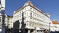
- No. 1 : Media tower of the News publishing group (architect: Hans Hollein ), completed in 2001. The “Croatian House” stood here until 1912, a small house in which Ignaz Wagner , father of a lover of Ferdinand Raimund's , was a café . He lived here shortly before his death. In the successor building ("ÖMV-Haus"), which was demolished in 1997, the mineral oil company OMV was located from 1955 .
- No. 2 , corner of Praterstrasse 1–7: Uniqa hotel and business building (Hotel Sofitel and Stilwerk , architect: Jean Nouvel , main address: Praterstrasse 1), opened in 2010. In 1770 a fire broke out here in the hostel for the “Golden Lamb”. when Emperor Joseph II was almost killed by a collapsing wall. Otto von Bismarck was a multiple visitor to the Hotel Continental , which was built on this site in 1873 and existed until 1945 .
- No. 8, 8A and 8B : Hotel Central, built in 1914 by Siegfried Theiss and Hans Jaksch ; previously a pub, then a Jewish prayer house. Furthermore, from 1916–1996 the Tabor cinema, originally one of the largest in Vienna with 1000, later 500 seats.
- No. 10 : Former stock exchange for agricultural products , today as the Odeon stage of the Serapionstheater , previously an inn
- No. 12 : Hotel Stefanie , named after Crown Princess Stephanie since 1872 , previously an inn
- No. 16 : Monastery church of the Barmherzigen Brüder with monastery and monastery pharmacy, Hospital of the Barmherzigen Brüder since 1614, hospital entrance: Große Mohrengasse 9
- No. 17, 17A, 17B : new building from 1911; previously large residential building Zum Goldenen Hirschen , including residence of Johann Strauss (father)
- between No. 17 and 17A : Lassingleithnerplatz
- between No. 17B and 19 : Karmeliterkirche St. Josef and Karmeliterplatz
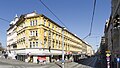
- No. 18 , at the corner of Schmelzgasse: Formerly Hotel National , built after 1847, architects Ludwig Förster and Theophil Hansen , building owned by the Hospital of the Barmherzige Brüder since 2009, a listed building since 2019, expansion planned for hospital purposes
- No. 20 , at the corner of Schmelzgasse: formerly the inn at Zum golden Brunnen , demolished in 1908
- No. 24 : This is where today's Sigmund-Freud-Gymnasium was located from 1864–1877 , at that time a municipal school; the gymnasium was in the neighboring house at Glockengasse 2. Freud graduated from high school here in 1873.
- at No. 26 : Memorial to Julius Ofner (1845–1924), social politician, member of the Reichsrat , member of the Constituent National Assembly in 1919; by Karl Wollek , unveiled in 1932, removed during the Nazi era in 1943, provisional in 1948 and finally re-erected in 1954; see also Ofnergasse
- No. 36 : The house built by Erwin Raimann in 1912 was formerly the Helios cinema (1913–1983/1988). The undulating bay facade shows relief fields with reclining nude figures in the parapet fields on the fifth floor.
- No. 39 , corner of Obere Augartenstrasse: formerly Hotel Bayrischer Hof with Bavarian beer parlor and ballroom
- at No. 39 and 40 : Taborstraße subway station (built 2003-2008)
- No. 72 : Around 1900 the future architect Richard Neutra lived here with his parents as a child .
- No. 80 , corner of Am Tabor 2: historical toll house Am Tabor (the northern end of Taborstrasse was long on the arm of the Danube that once flowed past here)
- at No. 89 : Johannes-Nepomuk-Kapelle (Am Tabor) (the border with the 20th district runs right next to the chapel)
- No. 89–93 : formerly the hall of the Nordwestbahnhof (20th district)
- No. 90–92 , Identity address: Trunnerstrasse 1–3: former Federal Agricultural and Chemical Research Institute , since 2001 seat of the District Court Leopoldstadt . The original first component ( kk agricultural chemical test station in Vienna ), Trunnerstraße 3, was built in 1893/94 by Franz Berger (1853–1938). The component and portal (Trunnerstrasse 1) located on Taborstrasse were probably built between 1898 and 1900.
- . No. 94 , corner Marinelligasse 1: Municipal Marinellihof, built in 1926 (Arch. Leopold Schulz ), named after Karl von Marinelli , director of the Leopoldstadt Theater
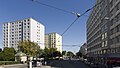
- No. 120 , identification address Leystraße 160: Education campus Christine Nöstlinger in the northern part of the railway, called “Flower” because of its characteristic floor plan, completion is planned for the 2020/21 school year.
traffic

17 years after the first horse-drawn tramway started operating in Vienna, this mode of transport ran for the first time from Schwedenbrücke through Taborstraße to Nordwestbahnhof in 1882 . But since 1869 it was already running on the Franz-Josefs-Kai and since 1873 the line 5, called since 1907 (and until today), which connects several Viennese terminal stations, crossed Taborstraße between Trunnerstraße (later Am Tabor) and Nordwestbahnstraße.
In 1897 the 5er was the first electric tram line in Vienna, the route through the inner Taborstraße followed in 1900. In 1901 the section from the Nordwestbahnhof to Dresdner Straße was built and immediately operated electrically. In the same year junctions were built into Heinestrasse (to Praterstern ; only used for diversions since 2008) and into Obere Augartenstrasse (to Augartenbrücke ; used for passenger traffic until 1945, removed decades later).
Various lines ran on these routes, the longest being the O (1907–1977) to Brigittenau and C (1910–1960) to Kaisermühlen . Line 2 has been running through Taborstraße since 2008, which meets the underground line U2 with the underground station Taborstraße at Oberen Augartenstraße . On the center side, the 2er drives the southern half of the ring line around the old town and ends in the north at Floridsdorfer Brücke in the 20th district.
At the southern end of Taborstrasse, across the Danube Canal, there is the Schwedenplatz underground station on the U1 and U4 lines .
For private traffic, the Taborstrasse northwards with the adjoining Dresdner Strasse etc. provides access to the Floridsdorfer Bridge over the Danube and the Danube bank motorway on the left bank . To the south, turn from Taborstraße upstream into Obere Donaustraße and downstream into Franz-Josefs-Kai . The cross-section of the roadway on Taborstrasse is small; In addition to parked vehicles, only the part of the road that is used by the tram is usually available to car traffic. Only in the northernmost part is the road a little wider.
Further information
- A design department store of the Stilwerk chain opened in December 2010 in the Uniqa hotel and business building at No. 2.
- Club Bricks is located on the corner of Blumauergasse, which is mainly frequented by young people . Flea markets take place several times a year in the entire alley.
- In the 2000s, the Taborstraße moved by the crime series Trautmann of the ORF television and the MR film in the media view.
gallery

The Taborstraße from No. 1, crossing Obere Donaustraße

No. 1, media tower

No. 2, Uniqa building

No. 10, product exchange

No. 11b, residential and commercial building

No. 12, entrance area Hotel Stefanie (oldest hotel in Vienna)
No. 17 (far left), 17A and 17B, residential and commercial building (before 17A: Lassingleithnerplatz)

No. 18, formerly Hotel National

At No. 19: Carmelite Church

No. 26, monument to Julius Ofner

From No. 27, Tandelmarktgasse intersection

No. 29, residential and commercial building

No. 31, residential and commercial building

No. 33, residential and commercial building

No. 35 and 37, residential and commercial building

No. 36, Former Helios cinema

No. 38, residential and commercial building
From No. 39, crossing Obere Augartenstrasse

From No. 65, Heinestrasse intersection
From No. 89, crossing Nordwestbahnstraße

No. 89, Johannes Nepomuk Chapel

No. 90–92, District Court

No. 94, Marinelli-Hof


Individual evidence
- ↑ Theater and cinema topography Vienna by the theater research office artminutes
- ↑ | ORF news from February 6, 2019
- ↑ Theater and cinema topography Vienna by the theater research office artminutes
-
^ The kk agricultural-chemical experimental station in Vienna. In: Der Bautechniker , year 1898, No. 26/1898, July 1, 1898 (XVIII. Year), p. 523 ff. (Online at ANNO ). ;
The kk agricultural chemical research station in Vienna. In: Wiener Landwirthschaftliche Zeitung. Illustrated magazine for the whole of agriculture , No. 98/1901 (1st year), December 7th, 1901, p. 834, bottom left. (Online at ANNO ). . - ↑ https://www.wien.gv.at/stadtentwicklung/architektur/oeffliche-bauten/schulbauten/bildungscampus-leopoldstadt.html
literature
- Helga Gibs: Leopoldstadt - Small world on the big river . Mohl Verlag, Vienna 1997, ISBN 3-900272-54-9 , p. 69-71 .
- Walter Krobot, Josef Otto Slezak , Hans Sternhart: Tram in Vienna - the day before yesterday and the day after tomorrow . Verlag Josef Otto Slezak, Vienna 1972, ISBN 3-900134-00-6 .
- Helmut Portele: Collection “Wiener Tramwaymuseum”. Vehicle preservation, documentation and operating museum. History of the “Wiener Tramwaymuseum” collection and its exhibits . Self-published by the collection “Wiener Tramwaymuseum” (WTM), Vienna ³2009, ISBN 978-3-200-01562-3 .
Web links
- Taborstrasse / Karmelitermarkt at wienwelt.at
Coordinates: 48 ° 13 ′ 17 ″ N , 16 ° 22 ′ 55 ″ E