
Volkertviertel

Volkertviertel is the name of a district in Vienna's 2nd district, Leopoldstadt . It was named after the Volkertmarkt , which is located in the center of the Grätzl . This name in turn refers to the count family Volkhra, Volkra or Volkert, who owned land and a palace in this area that was demolished at the beginning of the 20th century (see here ).
Starting from the Praterstern , it is the residential area bounded by Nordbahnstrasse , Heinestrasse , Castellezgasse, Scherzergasse and Am Tabor . In the 20th century, this quarter was sometimes combined with the adjacent Allied quarter to the north under the name " Nordbahnviertel ", but this name has been used since the 2010s for the newly built quarter on the site of the former freight station on the other side of Nordbahnstrasse or the railway line in Use.
Around 1880, the future nuclear physicist Lise Meitner grew up in this quarter (Heinestrasse 27, then Kaiser-Joseph-Strasse), a memorial plaque reminds of this.
building
There are several schools in the quarter ( Bundesrealgymnasium Vereinsgasse , formerly also a forerunner of the Sigmund-Freud-Gymnasium , Pazmanitengasse, Holzhausergasse). The primary school building, built in 1905 at Vereinsgasse 29–31, has neo-Gothic shapes.
The oldest building in the quarter is the old toll building (Am Tabor 2), which was built in 1698 by a bridge over the Fahnenstangenwasser , a now silted arm of the Danube. It was rebuilt in 1730 after a fire; a figure of St. John Nepomuk from the house chapel that was created around that time was transferred to the nearby Am Tabor line chapel in 1879 . In its function it corresponded to a line office . What is striking is the lower location compared to today's street level.
Another noteworthy building is the ÖBB administration building at Nordbahnstraße 50 opposite the former Nordbahnhof , which opened in 1873 as the Hotel Donau. It is under monument protection ( list entry ). Also striking is the late historical apartment complex of the so-called Haber-Hof in Nordbahnstrasse 46-48, which was built in 1891 and has facades to Darwin and Mühlfeldgasse - the corners are domed. The district also includes the former Roman Baths , which was opened in 1873 and closed in 1953, on Kleine Stadtgutgasse, of which architectural remains are still visible in Holzhausergasse.
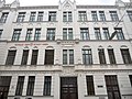
In Heinestrasse, the odd side of which is counted as a quarter, there is still some late historical inventory, albeit often in a later simplified form. House No. 13 was built by Viktor Klima in 1912, the bay windows are connected by neo-baroque balcony parapets. No. 21 by Wilhelm Stiassny dates from 1874; The column portal, which turns into a bay window, is striking.
The Castellezgasse was built with bourgeois apartment buildings in the 1870s and 1880s. The Hoerde machine factory (Castellezgasse 36–38) built around 1890 with its gable front facing Lessinggasse is the most important former industrial building in the area and the remainder of a larger complex. Nowadays it is mainly used for residential purposes.
The Volkertmarkt in the center of the quarter now has only about half as many stalls as it did in 1970. The brick stalls on the Rueppgasse side have since been removed.
traffic
The eastern and northern edges of the district are served by tram line 5, while the U2 subway line has stations just outside the area ( Taborstraße subway station , Vienna Praterstern train station ). Tram line 2 runs through Taborstrasse. Furthermore, bus line 5B runs through the district. Before this section of the U2 was opened in 2008, a tram line branched off from Taborstraße through Heinestraße and Mühlfeldgasse to Nordbahnstraße and Praterstern. The section of the route was still being used in autumn 2019 during a diversion in regular service.
gallery

The former toll building

Former Hotel Donau, the Haber-Hof in the background

Heinestrasse 21
Elementary school and former bath in the Vereinsgasse

Front of the former machine works Hoerde to Castellezgasse


Web links
Individual evidence
- ^ Nordbahnviertel in the Vienna History Wiki of the City of Vienna
- ↑ This and all of the following information is taken from Dehio II-IX & XX , District II: Residential and public buildings in the street association, pp. 22–41
Coordinates: 48 ° 13 '22.7 " N , 16 ° 23' 10.2" E