
Allied Quarter

Alliedviertel is the name for a district in Vienna's 2nd district, Leopoldstadt .
It is the residential area bounded by Taborstrasse , Nordbahnstrasse and Am Tabor . The axis of the quarter is the Allied Road, after which it is also named. The delimiting streets are used by tram lines 2 and 5.
In the 20th century, this quarter was sometimes combined with the Volkertviertel to the south under the name " Nordbahnviertel ", but this name has been used since the 2010s for the newly built quarter on the site of the former freight station on the other side of Nordbahnstraße or the railway line in Use. In the 2020s, a connection between these districts will be created via Schweidlgasse .
The term allies here does not go back to the allies of the Second World War, but to the powers Austria, Russia and Prussia allied against Napoleon . As a reminder of the meeting of the three monarchs that took place here in 1814 at the beginning of the Congress of Vienna , the Alliiertenstraße was named in 1909 , which leads through this district that was created decades later.
From 1945 after the end of the Second World War, the so-called Russenschleife , a connecting track between the Northern Railway and the Northwest Railway, was located at the northern end of the district . Northern railway trains could use this track to get to the north-west railway bridge over the Danube as long as the northern railway bridge was not navigable again.
building
On the southern edge of the quarter there are two churches on Am Tabor. No. 5 is the Evangelical Church of the Transfiguration , which began in 1914 and was completed in 1926 after an interruption due to the war; the church tower was built until 1965. Architects were Siegfried Theiss and Hans Jaksch . The parsonage is also part of the church and, like this, is under monument protection ( list entry ). The Roman Catholic parish church Am Tabor is located at number 7, between two wings of a multi-storey house . It was built by Ladislaus Hruska in 1967–1971 . The facade facing the street was designed by Arik Brauer in 1996 .
In Trunnerstrasse 1–3 (identical to Taborstrasse 90–92) is the former Federal Agricultural and Chemical Research Institute, built in 1893/94, which now houses the Leopoldstadt District Court. Around the same time, the Federal Institute for Plant Protection was built on Trunnerstrasse No. 5, which is set off from the street by a garden. This is to be merged with the green space in the gusset between Trunnerstraße and Am Tabor to form a parking area, the Else Feldmann Park .
At Marinelligasse 1 there is a municipal building built by Leopold Schulz in 1926 , the specialty of which is an asymmetrical courtyard facing Marinelligasse. A contrast is the late Secessionist-neoclassical building at No. 3, built by Alois Simona in 1914/15, with its giant Ionic pilasters.
For decades the Federal Institute for Plant Production and Seed Testing was located at the address Alliiertenstraße 1 (corner of Am Tabor / Trunnerstraße; see illustration). The building was converted into a residential complex and expanded by 2009.
A nine-storey building that dominates the area is the Chopinhof at the entrance to the street Am Tabor , a community building erected by Alfred Dreier and Otto Nobis between 1957 and 1959 , in whose green zone there is a play sculpture designed as a camel by Otto Eder .
On the other side of Taborstrasse, but still in the 2nd district, is the former line chapel , which is dedicated to the bridge saint Johannes Nepomuk . In fact, at the time of construction around 1728 there was a bridge over the now silted up flagpole water . It was functionally connected to the Am Tabor toll building (see under Volkertviertel). In 1963 it was moved a few meters to its present location.
gallery
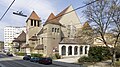
Transfiguration Church (left behind the Chopinhof)

District Court Leopoldstadt (left behind communal building Marinelligasse 1, front right Trunnerstraße)

Municipal housing at Marinelligasse 1

Marinelligasse 3

Trunnerstrasse 5

The Johannes Nepomuk Chapel


Web links
Individual evidence
- ^ Nordbahnviertel in the Vienna History Wiki of the City of Vienna
- ↑ All information in this section, unless otherwise specified, comes from Dehio II-IX & XX , pp. 22–41.
- ↑ The park project at wien.gv.at
- ↑ 2009 broadcast on the Samba housing project
Coordinates: 48 ° 13 ′ 33.7 ″ N , 16 ° 23 ′ 14.6 ″ E