Nordwestbahnstrasse (Vienna)
| Nordwestbahnstrasse | |
|---|---|
| Street in Vienna-Brigittenau | |
| Route Nordwestbahnstraße on OpenStreetMap | |
| Basic data | |
| place | Vienna-Brigittenau |
| District | Brigittenau |
| Created | 1876 |
| Cross streets | Taborstrasse , Scherzergasse, Nordpolstrasse, Rauscherstrasse, Kunzgasse, Adolf-Gstöttner-Gasse, Wallensteinstrasse , Waldmüllergasse, Brigittagasse, Pappenheimgasse, Leipziger Strasse, Hellwagstrasse |
| Places | Rabbi Schneerson Square |
| use | |
| User groups | Tram , bicycle traffic , pedestrian traffic , car traffic |
| Road design | Lane, cycle path and sidewalk separated from the street by a green strip |
| Technical specifications | |
| Street length | 1200 meters |
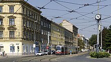
The Nordwestbahnstraße is a 1.2 km long residential and commercial road leading to the smaller part of the 2nd Viennese district ( Leopoldstadt ), and in the 20th district (for the most part Brigittenau is located). It runs on the western side of the former Vienna Northwest Station . It begins in the area closer to the city center at the traffic area Am Tabor on the outer Taborstrasse near Augarten , T-crosses Wallensteinstrasse and ends in the north at Leipziger Strasse or Hellwagstrasse. Due to the planned development of the north-west station area, the right side of the street will change massively in the 2020s.
Location and characteristics
The north-northwest running street is on the edge of the historic core of the old Brigittenau and begins near the Augarten , which is part of the 2nd district. The street begins at the end of the north-west station area closest to the city center, at an intersection where Taborstrasse, Am Tabor and Scherzergasse meet. After about 200 m of road there is the short North Pole Road to the west with a representative entrance to the Augarten. The western part of the street closest to the center with old buildings up to number 35A on Rabbiner-Schneerson-Platz, where Rauscherstraße branches off, belongs to Vienna's 2nd district. The ÖBB residential buildings opposite on the right-hand side of the street and the north-west station area are part of the 20th district. At Rabbiner-Schneerson-Platz there is still the old, closed station post office 1204 (No. 6), previously the main post office of the 20th district with postcode 1200.
In the northern part of the street, up to the highest orientation number 101, there are residential and commercial buildings on the left side of the street. On the right-hand side of the street facing the former train station, currently the highest straight house number is 16, there is the site with some still active companies. But there are already the first fallow land in the places where the BP petrol station and Böhler used to be. The ÖBB wanted to terminate all leased areas by the end of 2017 in order to be able to sell the station area as an urban development area.
A little north of the middle of the street length, the main street of Brigittenau, the Wallensteinstraße, branches off to the west from the Nordwestbahnstraße . Nordwestbahnstraße ends at the intersection with Pappenheimgasse, Leipziger Straße and Hellwagstraße, which crosses under the still existing railway line and leads into the Zwischenbrücken district towards the Millennium Tower . The originally planned continuation of the Nordwestbahnstraße to Stromstraße, already on the city map in 1898, has not yet been built.
history
In the time before the Viennese Danube regulation in the 1870s, the area on which the Nordwestbahnstraße runs could not be used economically intensively due to the recurring floods. The first known landowners were the Babenbergs in the 11th century. Around 1096 Leopold III. large areas of Brigittenau to the monastery of St. Maria Nivenburg (Klosterneuburg), which he founded, today's Klosterneuburg monastery . The monastery still owns land on Nordwestbahnstrasse. The meadow landscape, which was largely untouched before the Danube regulation and constantly changing by the river, was also an imperial hunting ground. From 1650 under Ferdinand III. a first garden was laid out for an existing hunting lodge, from which the Augarten later emerged. The southern area of the Nordwestbahnstraße from Fahnenstangenwasser to what is now Augarten belonged to the garden of Count Johann Franz von Trautson . In the 1660s, the Trautson Gardens were bought by the Habsburgs. The area was unsafe not only because of the water, but also because of its militarily exposed location far outside the city walls. During the second Turkish siege of Vienna in 1683, all the facilities in the Augarten were destroyed.
In the 17th century, the flagpole water, as the main arm of the Danube closest to the city, was very important for the supply of goods to the city. The Danube Canal , at that time still the Vienna Canal, had degenerated into a water-poor tributary due to countless floods since the Middle Ages. The wood delivered across the river was unloaded on the Augarten bank of the flagpole water. Flagpoles showed the ships and rafts the docks and the residents of the city that wood was there. At that time the Nordwestbahnstraße was still called Augartendamm and was located in Werd (= island in the river).
At the beginning of the 18th century, the flagpole water was just stagnant water. On Roscher's map from 1806, the western side of the Nordwestbahnstraße corresponds roughly to the bank of the flagpole water. At the Tabor, by today's Johannes-Nepomuk-Chapel , there was a "Kaltes Donau Baad", at the height of the Adolf-Gstöttner-Gasse another river "Baad". About at the level of Waldmüllergasse there was a ship mill in a small side arm. In 1831 an arched bridge over the flagpole water was mentioned. The change to a leisure area is visible through the emergence of facilities such as the Universum entertainment establishment , which stood roughly where the ÖBB residential buildings are today. The area was also known for illegal dog fighting by wealthy industrialists.
Even before the regulation of the Danube from 1868 to gain land for railway systems and industrial operations, the flagpole water was being filled in more and more. With the kk privileged Austrian Northwest Railway , extensive embankments were necessary for the construction of the station because of the risk of flooding and the filling of the branches of the Danube. In the course of this work, the route of today's Nordwestbahnstraße was probably completed; on the map from the 1770s there were land and water arms here. The soil for the embankments was transported from Heiligenstadt on a special field railway over the Danube Canal .
In 1872 the north-west station was opened. Apparently the name Nordwestbahnstraße gradually became established. On a map from 1873 it is still referred to as Wallensteinstrasse in the southern part . In 1876, Nordwestbahnstrasse appears for the first time in Adolph Lehmann's Vienna address book. The increased settlement of Brigittenau led to the restructuring of the streets and the disappearance of the old dam leading to the Augarten, which protected the Augarten Palace and the baroque gardens from flooding. Around 1872 the road in the vicinity of the Northwest Station was still in the development phase. It was said that Wallensteinstrasse was still unregulated, unlit and hardly built on. At that time, however, it reached as far as the Tabor. It was not until 1876 that it was divided into Rauscherstrasse and (lower) Nordwestbahnstrasse. At the time of the official naming, in 1876, the street was still entirely in Leopoldstadt . This only changed in 1900 with the separation of the new Brigittenau district. The section of the street from Leipziger Straße northwards to Stromstraße, which was drawn as completed on a city map around 1900, has not yet been built in reality.
In the course of the Danube regulation, a statue of Johannes Nepomuk in the Au was also moved here; it is now in the courtyard of house no.45.
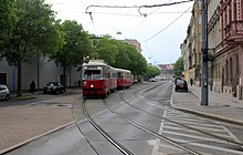
The horse-drawn tram has run through the street since 1873 and the first electrically operated tram line in Vienna since 1897 , known as line 5 ( Westbahnhof - Praterstern ) since 1907 and until today ; at that time it connected four terminal stations of the railway network going out from Vienna ( Westbahnhof , Franz-Josefs-Bahnhof , Nordwestbahnhof, Nordbahnhof ). Since 1928, line 31/5 (a combination of parts of lines 5 and 31), called line 33 since 1996 (today subway station Josefstädter Straße - Friedrich-Engels-Platz / Floridsdorfer Brücke ), ran over the Friedensbrücke.
In 1904, the tracks were much closer to the western side of the road. The Johannes Nepomuk Chapel was still in the middle of the intersection at Am Tabor and Nordwestbahnstraße. Line 5 came (until the 1960s) via Trunnerstraße to Nordwestbahnhof and from there to Nordwestbahnstraße. After the kk post office, where there is currently a supermarket, there was a shed. At the level of Wallensteinstrasse were covered coal slides or the locomotive shed for turning the locomotives.
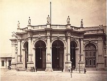
The once most beautiful building on Nordwestbahnstraße was the departure hall of the Nordwestbahnhof. The spacious semicircular vestibule was destroyed by Soviet fire in 1945 and was never rebuilt. It was level with Nordpolstrasse (Nordwestbahnstrasse No. 2-4). On the roof there were allegorical figures for the cities that have moved closer to Vienna thanks to the Northwest Railway. These were Dresden , Leipzig , Breslau , Berlin , Hamburg and Bremen . There were also four groups of children with the coats of arms of Lower Austria , Bohemia , Vienna and Prague . The figures were made from St. Margarethen sand-lime brick by the sculptor Franz Melnitzky . The vaulted ceiling was decorated with shields of various allegories and the names of specialists by the painter Pietro Isella from Morcote .
The interior design of the building was very elegant and planned down to the last detail by the Stuttgart architecture professor Wilhelm Sophonias Bäumer . There were plentiful coffered ceilings, rich wall paintings, wallpaper and pilasters, and exquisite lighting fixtures. The painter Hermann Burghart designed the 1st class waiting room, in which cities and views of the Northwest Railway could be seen. The sculptors Franz Schönthaler and Rudolf Winder worked in the court salon. After all, the train station was also the logical place of arrival of the German nobility in Vienna. For the common people there were waiting rooms for the II. And III. Class.
In 1924, due to the changed political situation after the First World War, passenger handling in the north-west station was stopped due to the lower number of passengers and moved to the north station . As a result, things became quieter in the lower Nordwestbahnstraße. The station hall, which had become useless, was only used for political and sporting events. In 1927 there was temporary skiing in the "Snow Palace". After the “Anschluss” of Austria , Hermann Göring , Adolf Hitler , Joseph Goebbels and other top Nazi politicians held propaganda speeches in the station hall on April 9, 1938, the day before the “referendum” on the integration of Austria into the German Reich. The anti-Semitic exhibition “ The Eternal Jew ”, shown soon after in the train station, was intended to legitimize the persecution of the Jews that had begun.
During the war, the Wehrmacht used the building as a warehouse. In 1943 passenger traffic was temporarily resumed. The north-west station was badly damaged by Soviet artillery bombardments during the Vienna operation in April 1945 shortly before the end of the war. The station building was demolished in 1952. Nevertheless, after the war, the trains of the northern railway were dispatched here, because this was interrupted by the blowing up of the northern railway bridge; the Nordwestbahnbrücke ( north bridge ), however, was already open again on August 25, 1945. The Soviet occupation forces needed a rail link to Russia, which is why the site was also under secret surveillance by the United States Information Service ( USIS ). In 1959, when the new Praterstern station of the northern line went into operation, passenger handling at the north-west station was finally stopped.
In the 1970s, the grounds of the north-west train station were expanded into what was then a modern freight and container terminal with crane systems and warehouses. There are two side entrances to the site from Nordwestbahnstraße, one at the level of Adolf-Gstöttner-Gasse and one at Waldmüllergasse. Until the truck parking ban at the beginning of the 1990s, Nordwestbahnstraße was characterized by trucks parked in the vicinity of the station.
The Nordwestbahnhof was now, although the second largest of the original six Viennese terminal stations, disappeared from the consciousness of the Viennese due to the long-ago shutdown of passenger traffic. The operation as a freight station was only noticed by the residents. The most famous place was the post office 1204, which was closed in 2012, at number 6 as the last remaining remnant of the old train station, which is currently in a state of decay.
future

Since the land on the right, eastern side of Nordwestbahnstraße is almost entirely owned by ÖBB , the future appearance of the street depends largely on the future of the Nordwestbahnhof area. The operation of an inner-city freight station has been anachronistic for decades, both in terms of land use and noise. In the past, residents in the vicinity of the train station always reported nightly noise from shunting activities.
At the site of the north-west train station, a new district of around 44 hectares is to be built from 2020, which is grouped around a “green center”. The first urban planning model had been developed by mid-2007 . On this basis, an architecture competition took place in March 2008 , in which the Swiss firm Ernst Niklaus Fausch Architects won first prize. For Nordwestbahnstraße, this concept means that, due to its location, it will become the most important access road to the site. Above all, around seven-storey residential buildings in perimeter block development are planned towards the Nordwestbahnstraße, which are separated by spur roads that have yet to be realized. The expansion or construction of new crossings with underground parking entrances is planned. A new tram line leading into this area is to cross the Nordwestbahnstraße at the level of Wallensteinstraße.
The old post office building at No. 6 is to be preserved.
Web links
Coordinates: 48 ° 13 ′ 55.4 " N , 16 ° 22 ′ 40.4" E
swell
- ↑ ÖBB-Immo sees historical buildings as' Assets! Der Standard , October 6, 2017, accessed December 8, 2017 .
- ^ Wohnpark Nordwestbahnhof (press conference by Planning Councilor Rudolf Schicker and Arch. Bertram Ernst, ENF Architects Zurich). Der Standard , August 31, 2009, accessed October 6, 2017 .
- ^ Felix Czeike : Historical Lexicon Vienna. quoted n. Wallensteinstrasse in the Vienna History Wiki of the City of Vienna
- ↑ Floor plan of the quays. also quays. Royal Head office and residence of the city of Vienna and its suburbs. Composed by I. v. Roscher, engraved by F. Reisser, published by T Mollo in Vienna. 1809.
- ^ Establishment of a new raft swimming and bathing establishment near Vienna. In: Popular Austrian Health Newspaper / Health Newspaper , March 2, 1831, p. 1 (online at ANNO ).
- ^ Siegfried Weyr: Vienna. A city tells. Vienna 1984, p. 358.
- ↑ Flagpole water in the Vienna History Wiki of the City of Vienna
- ^ Railroad News. In: Die Presse , No. 216/1869 (XXII. Volume), 6 August 1869, p. 6 (unpaginated), center left. (Online at ANNO ). .
- ↑ Lehmann 1876, entry at the bottom right
- ^ The stations of the Franz Josephs- and Nordwestbahn in Vienna. In: Neues Fremd-Blatt , May 30, 1872, p. 4 (online at ANNO ).
- ↑ Entry in the Vienna Cultural Property Register
- ^ Wien.gv.at: Generalstadtplan 1904 (Vienna History). City of Vienna , accessed on January 24, 2018 .
- ^ W. Bäumer: The north-west train station in Vienna. In: Allgemeine Bauzeitung , year 1873, XXXVIII. Volume (1873), p. 21 (text). (Online at ANNO ). .
- ↑ Little Chronicle. (...) The Nordwestbahnhof in temporary retirement. In: Neue Freie Presse , Morgenblatt, No. 21334/1924, February 1, 1924, p. 7, bottom center. (Online at ANNO ). .
- ↑ (caption :) The Führer’s final roll call to the German people. In: Das Kleine Blatt , No. 99/1938 (XII. Volume), April 10, 1938, p. 1. (Online at ANNO ). .
- ↑ (Annotated pictures of the exhibition at the Nordwestbahnhof :) Robert Körber: The Eternal Jew. In: Wiener Bilder , No. 33/1938 (XLIII. Volume), August 14, 1938, p. 6. (online at ANNO ). .
- ↑ In the picture archive Austria of the ÖNB 10 photos from the year 1953 have been preserved. Search for "Nordwestbahnstraße" . Retrieved January 3, 2018.
- ↑ Regionauten: criticism of savings glut at the post office. meinviertel.at, October 15, 2012, accessed on January 2, 2018 .
- ↑ viennaprofi1: Lost place - post office in 1204 Vienna, Nordwestbahnstraße. youtube.com, August 22, 2014, accessed January 2, 2018 .
- ↑ Overview of the urban development model
- ↑ The future of the tram in Vienna on wien.gv.at


