
Heiligenstadt (Vienna)
Heiligenstadt was an independent municipality until 1891 and is now a district of Vienna in the 19th district of Döbling as well as one of the 89 Viennese cadastral communities .
| Heiligenstadt | |
|---|---|
| coat of arms | map |

|

|
geography
Heiligenstadt is located on a beach terrace on the Vienna Danube Canal (a former arm of the Danube) and stretches in a narrow strip northwest up to the Kahlenberg . The cadastral municipality covers an area of 219.46 hectares . In the north, Heiligenstadt is bounded by Nussdorf and Josefsdorf , in the west by Grinzing and in the south by Unter- and Oberdöbling . The Probusgasse is the former village road and the current core of Heiligenstadt.
Heiligenstadt extends over 3 ditches that run from the Vienna Woods in the west to the Danube in the east: in the north the ditch of the Schreiberbach (Wildgrube, Muckental), in the center the ditch of the Nesselbach coming from Grinzing and in the south that of Neustift and Sievering (feeder Arbesbach ) coming Krottenbach , which runs south of the Hungerberg - Hohe Warte ridge .
history
Origin of name
The name Heiligenstadt is probably derived from the fact that there was a holy place in this area in pagan times. The place was first mentioned in 1120 as St. Michael . The Archangel Michael is also represented on the coat of arms. Only at the end of the 12th century did the addition Sanctum Locum (Heiligenstadt) appear in the documents. Ultimately, however, it is unclear what the designated holy place refers to. The thesis that Saint Severin von Noricum lived here has now been refuted.
Heiligenstadt to modern times

Heiligenstadt is an ancient settlement area that was settled 5000 years ago. The Romans also left their mark here. In 1872, in the area of Heiligenstädter Strasse-Pokornygasse-Bauernfeldgasse, remains of the wall were found, which occupy a defense tower of the Limes in this area. In addition, during excavations near the Jacob's Church, a Roman cemetery and an Avar grave from the 6th century were found nearby . The Franks finally began to settle Heiligenstadt around 900. The town center was originally grouped around today's parish square with the oldest church in this area. The residents, in turn, were farmers who mainly produced for their own needs. The catch of crabs and fish in the westernmost arm of the Danube (today Heiligenstädter Strasse) also played a role. Wine was grown for sale . The wineries of the wine wholesalers still lie on the hillside on Heiligenstädter Strasse. Klosterneuburg Monastery owned vineyards in Heiligenstadt as early as 1250 . After the death of pastor Heinrich, Bishop Weinhardt von Passau gave the monastery the right to take possession of the Heiligenstadt parish in 1304. In the Middle Ages, Heiligenstadt was one of the richer places in the area. A school is mentioned in documents as early as 1318, probably the only one far and wide. However, like many suburbs of Vienna, Heiligenstadt suffered greatly from the devastation from the 15th century onwards. In 1484 Matthias Corvinus plundered Heiligenstadt, in 1529 the looting of the Turks in the course of the first Turkish siege of Vienna seriously damaged the Jakobskirche and Michaelskirche . Due to the willingness of the residents of Döbling, Grinzing, Nussdorf and Heiligenstadt (all of whom still belonged to this parish) to make sacrifices, the Michaelskirche could already be restored in 1534.
Heiligenstadt in modern times


The Reformation only played a subordinate role in Heiligenstadt, but the Second Siege of Vienna by the Turks hit the place heavily. In 1683, many residents were massacred, which is a reminder of the Blutgasse. The devastation was so severe that the place looked like a wasteland. The economy did not recover until the 18th century when cattle farming and fruit growing conquered the Viennese markets. The public bath house in Heiligenstadt, which was built at the end of the 18th century and used a hot spring, contributed to the upswing of the place. Up to 300 people daily visited the spa with an attached inn.
This healing spring is mentioned in a hiking guide from the Biedermeier period , the work " Vienna's Environs for Twenty Hours Around " by Adolf Schmidl from 1835:
- A certain Johann Burger found healing from aching limbs in it, and in gratitude had the spring cleaned, grasped and led into his garden, by the current bathhouse. [...] As early as 1784, Dr. Klinger an analysis of the source (* Dr. Joh. Klinger: Description of the properties and effects of the Heiligenstädter Badwasser, Vienna 1791), of which the evil world wanted to assert that the power of the water was helped by iron bars thrown into it!
In the second half of the 19th century, however, the spring dried up, and the Heiligenstädter Park was built in place of the bath . In the 19th century, Heiligenstadt also gained its reputation as a summer resort , as a result of which wealthy Viennese citizens also settled in Heiligenstadt, and the place was frequented by tourists in the summer months. Also Ludwig van Beethoven lived temporarily in Heiligenstadt, where he wrote his Heiligenstadt Testament . Johann Strauss composed the Heiligenstadt Rendez-vous-Polka in 1850 .
In 1851 the Central Institute for Meteorology and Geodynamics , the state meteorological and geophysical service of Austria, was founded on the Hohe Warte .
Today's Heiligenstadt cemetery was laid out in 1873.
In 1795 there were 60 houses with 470 inhabitants who lived in three streets in the area of Grinzinger Straße, Probusgasse, Hohe Warte and Armbrustergasse. In 1832 677 people lived in 94 houses, in 1870 there were 3,393 people in 244 houses. Around 1890, numerous industrial companies settled here, while the population had meanwhile risen to 5,579 people. The number of houses had more than tripled within 60 years. The Heiligenstadt pond also fell victim to the construction boom. This 6,000 m² brick pond was used by the residents as a bathing pond, but became a problem because of the heavy pollution. It was filled in in the 20s of the 19th century.
Heiligenstadt after the incorporation
_-_Karl-Marx-Hof.JPG)
In 1892 Heiligenstadt was incorporated into Vienna together with the neighboring Viennese suburbs Sievering , Grinzing , Oberdöbling , Unterdöbling , Nussdorf and the Kahlenbergerdorf .
In 1898 the Vienna Heiligenstadt train station, designed by Otto Wagner , was opened as a transfer station between the Kaiser-Franz-Josephs-Bahn , which opened in 1870, and the Vienna Steam Light Railroad . From the latter, three routes ended in Heiligenstadt, namely the suburb line , the belt line and the Danube Canal line. From 1925 onwards, the Vienna Electric City Railroad ran on two routes to Heiligenstadt, which was finally incorporated into the Vienna U-Bahn in the 1970s and 1980s . The suburban line, in turn, has been part of the Vienna S-Bahn since 1987 . Today Heiligenstadt is also an important bus station for buses within Vienna and to Klosterneuburg .
After the First World War , the social democratic city government also began promoting social housing in Heiligenstadt in order to improve the poor living conditions of the workers. For this purpose, the huge Karl-Marx-Hof was built on an area that had been a navigable arm of the Danube until the 12th century and was later used by gardeners . Between 1927 and 1930, the Otto Wagner student and city architect Karl Ehn built the complex with 1382 apartments. The Karl-Marx-Hof became famous a short time later due to the February uprising , as numerous rebel workers holed up in it.
economy
Wine was still very important at the beginning of the 19th century. 30 percent of the floor space was used for wine growing, another quarter for arable farming. In addition, there was a 20 percent share of meadows and fruit was grown on around eight percent of the area. At the end of the 18th century, however, the first industrial companies also settled in Heiligenstadt. A sulfuric acid factory was built in Heiligenstädter Straße 135 in 1790 and existed until 1939. Other important companies were the parquet production Barawitzka, later Engel (1838 to 1932), the machine factory Heinrich (1840 to 1964) and the Just-Leitern-AG founded in 1885 and still existing in Lower Austria in Heiligenstädter Strasse 125. The importance of Heiligenstadt as a business location was taken into account after the founding of the Döbling district by dedicating the area between Heiligenstädter Strasse and the Danube Canal as an industrial area. But there were also important companies in the heart of Heiligenstadt. From 1889 onwards, the Kunz brothers built a coffee roastery, a malt and fig coffee production facility and a winery at Pokornygasse 7 . In 1919 pralines were also produced in Gatterburggasse, and in 1935 the business was sold to the Meinl company.
Culture and sights
- Heiligenstadt parish church of St. Michael
- Heiligenstadt Church of St. Jakob
- Unterheiligenstädter parish church
- Ludwig van Beethoven wrote his Heiligenstadt will on October 6, 1802 in Probusgasse 6 .
- In 1817 Beethoven lived in the Engelhartszellerhof, which was mentioned in a document in 1441, at Pfarrplatz 2 (memorial plaque, currently Heuriger ).
- Beethoven monument in Heiligenstadt Park
- Beethoven monument in the Beethovengang, one of Beethoven's favorite strolls
- Berghof (Pfarrplatz 5) from the 12th century (currently a restaurant), it is probably the oldest secular building in Vienna in front of the hay mill

Church Parish Church of St. Michael
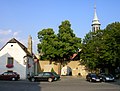
Pfarrplatz with St. Jakob church

Beethoven monument by Fernkorn in the Beethoven aisle

Beethoven monument in Heiligenstadt Park
_-_Kirche_St._Michael.JPG)


Sports
- The sports field of the Nußdorfer AC , which comes from the neighboring district of Nussdorf , is located in Heiligenstadt.
- The First Vienna FC 1894 (short: Die Vienna ) has played its games in the Hohe Warte stadium since 1899 .
- The Döblinger Bad is an outdoor and indoor pool on the Hohe Warte.
Personalities
- Rudolf Wondracek (1886–1942), architect, was born in Heiligenstadt
Web links
- Entry on Heiligenstadt (Vienna) in the Austria Forum (in the AEIOU Austria Lexicon )
Individual evidence
- ^ Adolf Schmidl: Vienna's surroundings for twenty hours in a circle. Described by Adolf Schmidl after his own hikes. Printed and published by Carl Gerold, Vienna 1835, pp. 58–59.
- ^ Heiligenstadt (Vienna) in the Vienna History Wiki of the City of Vienna
- ↑ Felix Czeike (Ed.): Vienna. Art and culture lexicon. City guide and manual. Süddeutscher Verlag, Munich 1976, ISBN 3-7991-5769-7 .
- ^ Heiligenstadt (Vienna) in the Vienna History Wiki of the City of Vienna
- ↑ Pfarrwirt - building history , accessed on March 1, 2020
- ^ Franz Mazanec: Döblinger Auslese: from the archive of Kurt Apfel. Sutton Verlag GmbH, 2011. pp. 78-81. google books online
Grinzing |
Heiligenstadt |
Josefsdorf |
Kahlenbergerdorf |
Neustift am Walde |
Nussdorf |
Oberdöbling |
Salmannsdorf |
Sievering (KG Ober- and KG Untersievering) |
Unterdöbling
Glanzing (part of Pötzleinsdorf in Döbling )
Coordinates: 48 ° 15 ' N , 16 ° 21' E