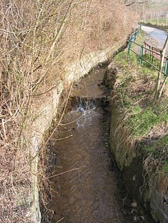
Schreiberbach
| Schreiberbach | ||
|
The Schreiberbach at Mukenthalerweg |
||
| Data | ||
| location | Vienna | |
| River system | Danube | |
| Drain over | Danube Canal → Danube → Black Sea | |
| source | in the Vienna Woods 48 ° 16 ′ 36 ″ N , 16 ° 19 ′ 9 ″ E |
|
| muzzle | Right collecting channel of the Danube Canal Coordinates: 48 ° 15 '35 " N , 16 ° 21' 58" E 48 ° 15 '35 " N , 16 ° 21' 58" E
|
|
| length | 4.2 km | |
| Drain | HHQ | 24.7 m³ / s |
| Big cities | Vienna | |
The Schreiberbach even Nussbach called, is a 4.192 km long river in the 19th Vienna district Döbling . The Schreiberbach rises in the Grinzing district between Vogelsangberg and Kahlenberg . In the upper reaches of the stream flows through the Wildgrube and then runs along the border between Grinzing and Heiligenstadt (Muckental). After the Heiligenstadt cemetery, the Schreiberbach finally flows through the Heiligenstadt district and a little later reaches Nussdorf , where the brook flows into a 400-meter-long brook canal. This leads the water of the Schreiberbach into the right collecting channel of the Danube Canal .
geography
The Schreiberbach rises a little south of the state border with Lower Austria between the Kahlenberg and the Vogelsangberg . Several small springs emerge in a piece of forest, which form the headwaters of the Schreiberbach. Above or north of this source area is the Sulzwiese with the Catholic Education House of the Schoenstatt Movement . About 150 meters below the source, the Schreiberbach runs beneath the Wiener Höhenstraße and then runs in an east-south-east direction through the so-called Wildgrube. A forest road also begins here, which follows the Schreiberbach on the left. In the upper reaches, the stream initially runs in a deeply cut, wooded valley. After a total of about 600 meters, the Schreiberbach takes on another source brook that rises north of the Schwabenwiese and south of the Schreiberbach origin. Here the stream flattens out for the first time and then takes in a further, smaller source stream from the left and right bank. This is followed by a further flattening of the river bed, as a result of which the valley widens more and more and the previously steep river flanks are much flatter. The stream finally reaches the Wildgrubgasse , which now accompanies the stream in a south-southeast direction through the Muckental, which is planted with vineyards. Then the stream comes into densely populated area and passes the Heiligenstadt cemetery . From the intersection of Wildgrubgasse / Kahlenberger Straße , the Schreiberbach is briefly led underground and then flows along the Beethovengang and the Zahnradbahnstraße . At the corner of Zahnradbahnstrasse and Eduard-Reyer-Gasse , the Schreiberbach finally flows into a 443 meter long brook canal , which directs the water from the Schreiberbach into the right-hand collecting canal of the Danube Canal , which was created in 1894–1904 .
history
The Schreiberbach was a constant threat to the town of Nussdorf due to the often rapidly swelling floods. In May 1851 the floods were so great that traffic in Nussdorf was only possible by ships. That is why in 1877 the arching of the brook from the Danube Canal up to the rack railway station was planned, which was decided in 1884 and carried out in 1885. Despite this measure, in 1886 Nussdorf was again flooded by the Schreiberbach. On Nussdorf Place (formerly Hirschenplatz) was in the old days, when the Schreiberbach still open ran a statue of St. Nepomuk , which is now at the bridge on Eroicagasse .
environment
Construction measures and bank condition
The Schreiberbach was built for the first time just below the headwaters. Below the high road, the stream is led through a high, concrete U-profile, next to which the forest path accompanying the stream runs parallel. Then the stream runs in a deeply cut valley, whereby the bank is not touched by the higher forest path. While the course of the bank flattens out more and more after the confluence of further source streams, the stream initially runs in its original stream bed and forms small meander stretches in the leveling areas. The first construction measures can be found again for the first time shortly before the junction of the path to Kahlenberg at the end of Wildgrubgasse. Here the speed of the stream is reduced by artificial defensive walls and steps. In the further course, free flowing stretches alternate with defensive walls and fortified steps. In addition, the left bank of the stream is often hard-built due to the nearby road. Only the leveling of the Muckental offered the Schreiberbach increasing space again, which reduced the construction measures. From the Heiligenstadt cemetery, the bottom and the lower section of the bank of the Schreiberbach are hard-built, which results in a high flow velocity in this area. The Schreiberbach then runs underground for a short time, only to flow through a hard-built profile. The left bank is built much higher due to the proximity to the road. From the Eroicagasse, the Schreiberbach finally runs in a concreted U-profile to the confluence with the Bachkanal.
fauna and Flora
The Schreiberbach is mainly accompanied by deciduous forest in the upper reaches. The umbrella pines typical of the Vienna Woods can only be found in a small area . In the middle reaches, however, the slopes of the Schreiberbach are used for viticulture.
literature
- Karl Kothbauer: Döbling - and its reed and field names . Dissertation, Vienna 2001.


