Pötzleinsdorf
| Pötzleinsdorf | |
|---|---|
| coat of arms | map |

|

|
Pötzleinsdorf is a district of Vienna in the 18th district of Währing and one of the 89 Viennese cadastral communities . A small part of Pötzleinsdorf is in the 19th district of Döbling in Vienna .
geography

222.12 hectares of Pötzleinsdorf are in the west of the 18th district and 34 hectares in the south of the 19th district. The cadastral community extends over an area of 256.12 hectares. Pötzleinsdorf borders Neustift am Walde and Sievering in the north, the districts of Währing and Gersthof in the east, Dornbach in the south and Neuwaldegg in the west . The boundary course of the statistical census district Pötzleinsdorf, which consists of five census districts, differs from that of the cadastral community of the same name.
The part located in the 19th district is called Glanzing .
Origin of name
Pötzleinsdorf was first mentioned in 1112 as pezelinesdorf in a document of the St. Georgen an der Traisen monastery and goes back to a proper name. Local lore, however, has created its own story. According to this, a knight's castle should once have stood on the nearby Schafberg. One of the knights is said to have once defeated a bear with his bare hands and trained him like a dog in the castle. Thereupon the knight was called "Petzler", the associated village Petzlersdorf.
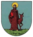
The town's coat of arms shows the local patron saint, St. Aegidius . He is typically depicted as a Benedictine monk with a crook and hit by an arrow and is shown accompanied by a doe . The parish church of Pötzleinsdorf is dedicated to St. Aegidius.
history
Pötzleinsdorf was probably founded as a Central German - Franconian branch. Presumably the namesake of the village had received the area as a gift or fief . At the beginning of the 14th century, however, the manorial power went downhill. In 1322 Stefan von Pötzleinsdorf only appeared as a mountain master. The old castle had meanwhile become a Freihof . The settlers, serfs of the landlords, mainly operated viticulture , and there was only limited agriculture .
The manor was changeable. For a century and a half, Pötzleinsdorf belonged to the St. Agnes women's monastery at Himmelpforte. After Emperor Josef II had closed the monastery in 1783, Countess Philippina von Herberstein acquired the property. In 1801 the Viennese banker Johann Heinrich Geymüller came into possession of the area.
The second Turkish siege of Vienna had severely damaged the place in 1683, but Pötzleinsdorf recovered from the devastation very quickly. Today's bakery called Zum Türkenloch is a reminder of the place where a large, long hole was found after the end of the second Turkish siege. The meaning is not clear, maybe this hole was dug by the Turks to tunnel under the city fortifications. The Turkish cross at the end of Schafberggasse is also a witness from this time.
However, a major fire in 1750 stopped development, 31 of the 32 houses and the church burned down. The place recovered only with difficulty, in 1832 the place had 32 houses as well as in 1750. In contrast to the surrounding towns, Pötzleinsdorf hardly grew in the second half of the 19th century. Although three times the size of the neighboring Gersthof, Pötzleinsdorf had only 173 houses in 1890 and much of its character as a wine-growing village had been preserved.
In 1890 the Lower Austrian provincial committee decided to unite Vienna with the suburbs. The law came into force on January 1, 1892 and united Pötzleinsdorf, Währing , Gersthof , Weinhaus , Neustift am Walde and Salmannsdorf to form the 18th district of Währing (today Neustift am Walde and Salmannsdorf belong to the 19th district of Döbling ). The area of the former village of Pötzleinsdorf was originally 2.74 km², the second largest part of the new district, but in 1890 only housed 737 inhabitants.
Culture and sights
The remote location of Pötzleinsdorf and the quiet, upscale character of the area make it a popular local recreation destination. The old village center of Pötzleinsdorf with its one-story old houses is still relatively well preserved and recognizable. The Egydius Church is the former parish church, in the 1960s the new Pötzleinsdorfer parish church was built a little further into town.
Pötzleinsdorfer Straße is lined with several villas from the Wilhelminian era , which today include the residences of ambassadors ( Pakistan , Uzbekistan , Madagascar ). The Pötzleinsdorfer Strasse is the former Schlossstrasse, which leads directly to the Pötzleinsdorfer Schlosspark with the Pötzleinsdorf Castle , both from the Baroque period and redesigned several times. To the north of the park is the Geymüllerschlössel , a gem from the Biedermeier period , which is now a branch of the Museum of Applied Arts . Behind the Geymüllerschlössel is the Pötzleinsdorfer Friedhof , a facility from the 18th century.
Glanzing (the part in the 19th district) is mainly occupied by the cooperative settlement built in 1923/24. There is also a children's clinic built between 1912 and 1914 . The Glanzingen parish church is already in Obersievering .
religion
In 1638 a small chapel for about 20 residents is said to have existed in Pötzleinsdorf . After the ravages of the Turks in 1683, the chapel was destroyed. During the reconstruction of the place, a new chapel was built, which was consecrated to St. Aegydius. However, the chapel was demolished in 1743 and replaced by a larger church. After the entire place burned down in 1750, the baroque Aegydius Church was rebuilt in its current form. A priest could be employed as a local chaplain through a generous foundation . Finally, after the abolition of the monastic manor in 1784, Pötzleinsdorf was separated from Währing and raised to its own parish. Due to the growth of the community after the Second World War, the Christ the King's Church was built next to the Pötzleinsdorfer Castle in 1963 according to a design by Karl Schwanzer as the new Pötzleinsdorfer parish church.
There was a small Jewish community before the war; the Währing temple was responsible for the worship service . Villas owned by Jews such as the Geymüllerschlössel, the Regenstreif villa or the Eisler family's house and their art collection at Pötzleinsdorfer Strasse 29 were confiscated by the Nazis, the Eisler family deported and murdered in Riga . The local Pötzleinsdorfer population took part in the looting of Jewish property. Only a few Jewish citizens returned or settled again after the war.
The Pötzleinsdorf parish organizes symposia and discussion groups to come to terms with this past. Events and projects such as “ A Letter To The Stars ” or “Finding Traces” by the Gojim music group try to bring the subject of persecution of Pötzleinsdorf and Währingen Jews closer to school children.
Personalities
- Ferdinand Stamm (1813–1880), writer, journalist and politician, lived in Pötzleinsdorf
- Carl Caro (1850–1884), poet and stage poet, died in Pötzleinsdorf
- Moritz Schlick (1882–1936), philosopher and physicist, buried at the Pötzleinsdorfer Friedhof
- Franz Barwig the Younger (1903–1985), sculptor, lived in Pötzleinsdorf
- Herbert Tichy (1912–1987) travel writer, geologist, journalist and mountaineer, lived in Pötzleinsdorf
- Edith Klinger (1922–2013), actress, animal rights activist , lived in Pötzleinsdorf
- Kurt Regschek (1923–2005), painter, lived and worked from 1967 in Pötzleinsdorf
- Aglaja Schmid (1926–2003), actress, lived in Pötzleinsdorf
- Heinz Holecek (1938–2012), singer, lived in Pötzleinsdorf
- Sieghardt Rupp (1931–2015), actor, lived in Pötzleinsdorf
literature
- Christine Klusacek, Kurt Stimmer: Währing. From the Ganserlberg to the Schafberg. Mohl, Vienna 1992.
Web links
- The history of Pötzleinsdorf on the Pötzleinsdorf parish website.
- History of Pötzleinsdorf on the website of the Währing district museum .
Individual evidence
- ^ Eisler, Alfred (estate) in the Lost Art Internet Database, accessed June 30, 2011.
- ↑ gojim newsletter 05/07 . Retrieved June 30, 2011.
Coordinates: 48 ° 14 ' N , 16 ° 19' E


