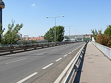
Belt Bridge
The Gürtel bridge in Vienna connects the Alsergrund (9th) and Döbling (19th) with the Brigittenau (20th district). It was built between 1962 and 1964 as a prestressed concrete bridge (crossing the Danube Canal: 138.3 meters in length) by A. Porr AG based on plans by Alfred Pauser and Herbert Wycital.
Transport links
The bridge, which is around 600 m long, including access and exits, crosses from its western end on Heiligenstädter Strasse (9th / 19th district) the Franz-Josefs-Bahn , the U4 underground line and the Danube Canal to its eastern end Brigittenauer Lände (20th district).
The bridge is located in the northern extension of the belt and forms the border between the 9th and 19th district from Heiligenstädter Straße to Heiligenstädter Lände on the Danube Canal. In a north-easterly direction via Adalbert-Stifter-Strasse (20th district) and Floridsdorfer Brücke, you can drive to the A 22 along Hubertusdamm (21st district) and to Floridsdorf (21st district, B 3 Prager Strasse and B 7 Brünner Strasse ). It is the end point of the B221 .
The Spittelauer Brücke (B 227) has been branching off from the Gürtel bridge in the east before the Danube Canal since 1992 , which crosses the Danube Canal roughly parallel to the Gürtel Bridge and joins the Brigittenauer Lände (B 227) in the direction of the Nordbrücke . Before 1992 there was a direct exit from the Gürtelbrücke to the land that was in the way of the U6 Danube Canal Bridge and the subsequent underground tunnel portal and was therefore removed. In the opposite direction you can get from the north bridge (A 22) to the Nussdorfer or Heiligenstädter Lände (also B 227) to the south with a driveway to the Gürtel bridge towards Döblinger Gürtel .
Immediately south of the bridge in the 9th district is the Josef-Holaubek-Platz federal office building , the Spittelau station on the U4 and U6 lines, as well as the Franz-Josefs-Bahn and the Spittelau waste incineration plant designed by Friedensreich Hundertwasser . The Brigittenauer Bad is located south of the bridge exit in the 20th district .
history
The "planned transfer of the belt over the Franz Joseph train station in the course of Guneschgasse" (the district boundary 9/19 is still located there today) was a sentence in the announcement of the kk Lower Austrian governor of June 7, 1905, with which he details on the new demarcation between some of Vienna's municipal districts .
Adalbert-Stifter-Straße, which adjoins the bridge in the 20th district, was already marked as a projected street in the city map from 1912, but according to the city map, it was not built by the entire district as late as 1961, but rather "blocked" by older buildings. Today's thoroughfare was only broken through in the course of the construction of the belt bridge and expanded to four lanes.
A departure from the bridge to Brigittenauer Lände was removed in the early 1990s and replaced by a new connection (see section Transport connections).
From October 2012 to September 2015, all supporting structures were fundamentally renovated and a staircase and a subordinate bridge object were newly built. The gross costs were estimated at around 21 million euros. Despite the insolvency of the first contractor (Alpine Bau GmbH), the work was completed within the planned 3-year construction period.
Web links
Individual evidence
- ^ State law and regulation gazette for the Archduchy of Austria under the Enns, Vienna, No. 104/1905
- ↑ wien.at, Bridge Construction and Foundation Construction: Repair work on the Belt Bridge - 2012 to 2015
literature
- Christine Klusacek, Kurt Stimmer: The city and the electricity. Vienna and the Danube . DACHS Verlagsges.mbH, Vienna 1995, ISBN 3-85058-113-6
- Alfred Pauser: Bridges in Vienna - A guide through the history of construction . Springer Verlag, Vienna 2005, ISBN 3-211-25255-X
Coordinates: 48 ° 14 ′ 10 ″ N , 16 ° 21 ′ 40 ″ E

