Silly
| Silly | |
|---|---|
| coat of arms | map |

|

|
Albern was an independent municipality in Lower Austria until 1938 and is now part of Vienna's 11th district of Simmering and one of the 89 Viennese cadastral communities .
geography
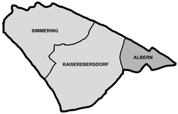
Albern is located on the southern right bank of the Danube Canal and the Danube in the east of Simmering. At 152 m above sea level, Albern is one of the lowest parts of Vienna. The cadastral community extends over an area of 258.61 hectares . In the south of the district, Vienna's city limits run to Mannswörth and Schwechat . To the west of the former town are the two other districts of Simmering, the immediately adjacent Kaiserebersdorf and to the west of it the district center of Simmering . The Albern Hafen freight station is connected to the Donauländebahn (with the former Kaiser-Ebersdorf Albern passenger stop ), which has been connected to the Donauuferbahn since 2009 via the Winterhafenbrücke (as it was until 1945) .
The district near the Danube Canal is called Neu-Albern. It is located in the triangle between the Alberner Hafenzufahrtsstraße in the north, the Donauländebahn in the west and the railway line to the Alberner Hafen or the Neubach, which disappeared from the city plans between 1976 and 1983, until then the confluence of the Schwechat into the Danube, in the southwest and south. Neu-Albern emerged as a street settlement after 1900 far from the historical center of Albern.
history

The first documentary mention of the place took place in 1162 as Albrah in a deed of donation from Emperor Friedrich I. The deed is now in the Lower Austrian State Museum . The name is derived from the alb poplar, the silver poplar , which grew in this area. Until the Middle Ages, the rulership included the four places Mirnitz, Porca, Cygeyswierth and Albrah. The inhabitants of the small towns lived mainly from fishing . (Based on this, two crossed fish on a blue background were used as a motif for the part of the Simmering coat of arms intended for fools.)
In the flood- plagued area, only today's silly remained. The place was completely destroyed in 1501, 1618 and 1775 and had to be rebuilt. Only the regulation of the Danube in Vienna, completed in 1875, improved the situation considerably. The population increased from 166 before regulation to 524 in 1900.
The place initially remained unaffected by industrialization. During the 18th century, however, there was a textile factory near Albern for a time. Only after Austria was "annexed" to the German Empire did the place undergo a major expansion. With the Reich Law of October 1, 1938, which came into effect on October 15, Vienna was enlarged to become Greater Vienna . Albern, until then Vienna's immediate neighboring municipality (with the Donauländebahn as the city boundary), became part of Vienna as part of Vienna's new 23rd district Schwechat. In the years 1939 to 1942, a huge grain port was built by forced laborers to transport grain from Eastern and Southeastern Europe to Germany.
After the Second World War , all parts of Greater Vienna that were incorporated in 1938 belonged to Lower Austria under occupation law, to the Soviet zone, including Albern; the administration was still to be provided by the city of Vienna. When the area change law passed in 1946, with which large parts of the areas incorporated in 1938 were to return to Lower Austria, came into force in 1954, Albern was to be connected to the British-occupied 11th district. In order to be able to keep the port of Albern, the Soviet Union enforced that Albern became part of the 2nd district it occupied . Since 1954, as until 1938, Albern has been located directly on the city limits, but this time within Vienna. After the conclusion of the state treaty , Albern came to the 11th district on January 1, 1956.
Silly today
Silly is best known for the Nameless Cemetery . Between 1840 and 1940, a total of 582 Danube corpses were buried in the cemetery, which is divided into an old and a new part. The cemetery, which has not been reoccupied for a long time, is recognized as a monument and is looked after by the cultural department of the City of Vienna.
The three mighty granaries of the Albern harbor, built in 1939 and owned by the Port of Vienna, can be seen from afar, including from the A4 Ostautobahn (airport motorway), which runs (partly parallel to the Donauländebahn) between Albern and the neighboring Kaiserebersdorf to the west. A flood protection gate has been erected in the port area since 2010, as it already exists in the Freudenau port ; it is intended to protect the port area from flooding that sometimes occurs. To the north of the port basin (1st jetty south, 2nd jetty north of the basin) is the blue water, an oxbow lake of the Danube surrounded by alluvial forest.
Culture
The Hafen Open Air pop festival has been taking place every summer since 2006 and admission is free.
Web links
- History of Kaiserebersdorf and Albern on the wien.at website
- Vienna - Alberner Hafen ( Memento from March 5, 2009 in the Internet Archive )
Individual evidence
- ↑ The conductor. Official cours book of the Austrian railways. Small edition, Verlag R. v. Waldheim, Vienna 1901, p. 24
Coordinates: 48 ° 10 ' N , 16 ° 30' E

