Brennerstrasse
| State road B182 in Austria | |||||||||||||||||||||||||||||||||||||||||||||||||||||||||||||||||||||||||||||||||||||||||||||||||||||||||||||||||||||||||||||||||||||||||||||||||||||||
| 182 | |||||||||||||||||||||||||||||||||||||||||||||||||||||||||||||||||||||||||||||||||||||||||||||||||||||||||||||||||||||||||||||||||||||||||||||||||||||||
| Basic data | |||||||||||||||||||||||||||||||||||||||||||||||||||||||||||||||||||||||||||||||||||||||||||||||||||||||||||||||||||||||||||||||||||||||||||||||||||||||
| Start of the street: |
Innsbruck ( 47 ° 15 ′ N , 11 ° 24 ′ E ) |
||||||||||||||||||||||||||||||||||||||||||||||||||||||||||||||||||||||||||||||||||||||||||||||||||||||||||||||||||||||||||||||||||||||||||||||||||||||
| End of street: |
Brenner ( 47 ° 0 ′ N , 11 ° 30 ′ E ) |
||||||||||||||||||||||||||||||||||||||||||||||||||||||||||||||||||||||||||||||||||||||||||||||||||||||||||||||||||||||||||||||||||||||||||||||||||||||
| Overall length: | 36.6 km | ||||||||||||||||||||||||||||||||||||||||||||||||||||||||||||||||||||||||||||||||||||||||||||||||||||||||||||||||||||||||||||||||||||||||||||||||||||||
|
State : |
|||||||||||||||||||||||||||||||||||||||||||||||||||||||||||||||||||||||||||||||||||||||||||||||||||||||||||||||||||||||||||||||||||||||||||||||||||||||
| Brennerstrasse, view over Stafflach into the Schmirntal | |||||||||||||||||||||||||||||||||||||||||||||||||||||||||||||||||||||||||||||||||||||||||||||||||||||||||||||||||||||||||||||||||||||||||||||||||||||||
|
Course of the road
|
|||||||||||||||||||||||||||||||||||||||||||||||||||||||||||||||||||||||||||||||||||||||||||||||||||||||||||||||||||||||||||||||||||||||||||||||||||||||
The Brennerstraße ( B 182 ) is a state road in Austria in the state of Tyrol with a total length of 36.6 km.
course
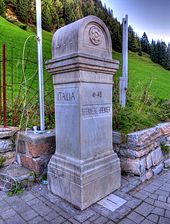
The Brenner road branches in Innsbruck from the Innsbruckerstraße (B 174) in the "Graßmayrkreuzung" and leads to the south under the Europe bridge through the Tyrolean Wipptal with communities Schönberg in the Stubai Valley , Matrei am Brenner , Steinach and Gries am Brenner to the state border at the Brenner Pass , where it continues as Italian State Road 12 . The road is closed to through-traffic of trucks over 3.5 t, so that these vehicles have to use the toll Brenner motorway, which runs largely parallel .
history

At the beginning of the 3rd century, under Septimius Severus, the route over the Brenner Pass was expanded into a Roman road. The connection known today as Via Raetia is already recorded in the Itinerarium Antonini and the predecessor of the medieval Via Imperii .
The Brenner Pass was already the most popular crossing in the Eastern Alps in the Middle Ages (around 1430, 6500 freight wagons were already using the route from Augsburg via the Brenner to Verona and Venice), so the road was re-routed and improved several times. Archduke Ferdinand II had the road leading to the Brenner pass over the Schönberg between 1582 and 1584 because the old road had proven to be too steep and many carters preferred to use Ellbögener Strasse . Their absence resulted in important financial losses for the capital Innsbruck. In 1777, under Empress Maria Theresa , the Brennerstrasse was expanded into a road that can be used all year round. From 1836–1844, today's road was built between Innsbruck and Schönberg, which was opened to traffic on November 1, 1844. The state border between Austria and Italy has been running on the Brenner Pass since 1919.
The Brenner-Strasse is one of the former Reichsstrasse, which was taken over as federal roads in 1921. Until 1938, the Brenner-Straße was designated as the B 66, after the connection with Austria , the Brenner-Straße was part of the Reichsstraße 2 until 1945 .
The Ellbögener Straße , which ran along the route of the historic Römerstraße and led from Hall past Innsbruck to Matrei, was also used as a federal road from 1921 to 1973. Until 1938 Ellbögener Strasse was designated as B 66a, from 1949 it was run as B 184 before it was devalued to a Tyrolean state road ( L 38 ) on January 1, 1973 .
Since January 1st, 1973, the Brenner Strasse no longer begins in the city center of Innsbruck, but on Innsbrucker Strasse .
On May 15, 2002 the name of the Tyrolean Parliament was changed to Brennerstrasse .
literature
- Werner Rutz: The Brenner traffic routes: road, rail, motorway. Course and performance . Federal Research Institute for Regional Studies and Regional Planning, Bonn-Bad Godesberg 1970.
Web links
swell
- ^ Martin Kluger: The Fugger in Augsburg , p. 13 ISBN 978-3-939645-63-4 . Reading sample (PDF, 1 MB)
- ^ Wiener Zeitung of October 18, 1844, Official Gazette, p. 656.
- ^ Federal law of July 8, 1921, regarding federal highways. Federal Law Gazette No. 387/1921.
- ↑ Announcement by the Federal Minister for Buildings and Technology of September 3, 1973 in accordance with Section 33 (4) of the Federal Roads Act 1971 with regard to the State of Tyrol, Federal Law Gazette No. 496/1973.
- ↑ Decision of the Tyrolean Parliament of May 15, 2002, published in State Law Gazette No. 68/2002 ( Memento of January 13, 2016 in the Internet Archive ) (PDF; 66 kB)
| B182 | Like the other former federal highways, Brennerstrasse was part of the federal administration. Since April 1, 2002, it has been under state administration and continues to have the B in the number, but not the name Bundesstraße. |
