
Arlbergstrasse
| State road B197 in Austria | |||||||||||||||||||||||||||||||||||||||||||||||||||||||||||||||||||||||||||||||||||||||||||||||||||||||

|
|||||||||||||||||||||||||||||||||||||||||||||||||||||||||||||||||||||||||||||||||||||||||||||||||||||||
| Basic data | |||||||||||||||||||||||||||||||||||||||||||||||||||||||||||||||||||||||||||||||||||||||||||||||||||||||
| Start of the street: |
St. Anton am Arlberg ( 47 ° 9 ′ N , 10 ° 19 ′ E ) |
||||||||||||||||||||||||||||||||||||||||||||||||||||||||||||||||||||||||||||||||||||||||||||||||||||||
| End of street: |
Langen am Arlberg ( 47 ° 8 ′ N , 10 ° 7 ′ E ) |
||||||||||||||||||||||||||||||||||||||||||||||||||||||||||||||||||||||||||||||||||||||||||||||||||||||
| Overall length: | 21.0 km | ||||||||||||||||||||||||||||||||||||||||||||||||||||||||||||||||||||||||||||||||||||||||||||||||||||||
|
State : |
|||||||||||||||||||||||||||||||||||||||||||||||||||||||||||||||||||||||||||||||||||||||||||||||||||||||
|
Course of the road
|
|||||||||||||||||||||||||||||||||||||||||||||||||||||||||||||||||||||||||||||||||||||||||||||||||||||||
The Arlbergstrasse (L 197 / B 197) is a state road in the Austrian federal states of Tyrol and Vorarlberg .
Course and expansion
The road leads from St. Anton am Arlberg (1284 m) in the Stanzertal via St. Christoph , the Arlbergpass (1793 m) and Stuben to Langen am Arlberg (1228 m) in the Klostertal . It therefore connects Innsbruck via Landeck in the Oberinntal , the Rosanna valley , the Alfenz , and Bludenz im Walgau in the Ill valley to Feldkirch in the Vorarlberg Rhine Valley , and thus connects these two important north-south axes of the Alps .
The Arlbergstrasse is banned from driving towing vehicles with trailers with a total mass of more than 0.4 t ( Denzel-Alpenstrasse scale SG 2). A winter closure is only temporarily imposed if there is an acute avalanche danger .
history
The pass has probably been used since at least the Bronze Age , the old road was of little interest in Roman times . From the 13th century, however, there are more and more records of traffic on the route. Up until the 18th century there was only a mule track between the two valleys: the Allgäu people had economic interests in keeping east-west traffic in the foothills of the Alps, while the Habsburgs had military interests in keeping the western border of Tyrol impassable and therefore safe.
From 1782 to 1784, however, under Joseph II, the road was built by Bolzano traders and in 1787 the Josephinische Strasse was opened across the Arlberg. By 1824, a paved art road was built on the east ramp bypassing St. Anton via St. Jakob and Nasserein . In early industrialism it was important for the Vorarlberg and Eastern Switzerland textile industry and postal traffic, but lost its importance again with the expansion of the railways over the foothills of the Alps.
After the fall of the Habsburg monarchy , efforts were made to establish a continuous connection within Austria, and the rise of ski tourism on the Arlberg also increased local traffic after the war. With the Federal Road Act of 1971, the pass road became the B 197 federal road .
1974 to 1978 the 14 kilometer long Arlberg road tunnel and the Arlberg expressway S 16 were built. As a result, the pass road, as a secondary route to the tunnel section, finally became a local traffic route, but also a tourist route. It is used again and again as a diversion route when the tunnel is closed.
With the abolition of the federal highways in 2002 it was converted into one or two state roads , the designation remained in Tyrol B 197, in Vorarlberg it is designated as L 197.
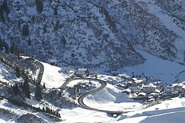
From 2014 to 2015, a 1.3 km long section between Stuben (Posteck) and Alpe Rauz threatened by rockslides was re-routed after lowering of the lane and damaged protective and retaining walls had been ascertained in this area and the costs for renovation would have been higher , as a re-routing. Instead of the previous carriageway running parallel to the Rauzbach, the traffic is now routed in serpentines onto the previous Lechtalstraße and from there to the Alpe Rauz. The new route was opened to traffic in October 2015, the old route will be abandoned and renatured.
gallery

St. Christoph am Arlberg just below the Arlberg Pass, 1889

Tyrolean ascent of the pass road

2015 New alignment of Arlbergstrasse
Sweeping at Stuben on the Vorarlberg side


Web links
Individual evidence
- ↑ New alignment of L 197 Arlbergpassstraße. Retrieved August 9, 2019 .
|
L197
|
Like the other former federal highways, Arlbergstrasse was part of the federal administration. Since April 1, 2002 it has been under state administration. In the other federal states, the conventional street name is continued with B - in Vorarlberg, however, the streets taken over by the federal government have an L in the name like all other Vorarlberg regional streets . |