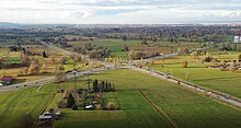
Vorarlberger Strasse
| State road L190 | ||||||||||||||||||||||||||||||||||||||||||||||||||||||||||||||||||||||||||||||||||||||||||||||||||||||||||||||||||||||||||||||||||

|
||||||||||||||||||||||||||||||||||||||||||||||||||||||||||||||||||||||||||||||||||||||||||||||||||||||||||||||||||||||||||||||||||
| Basic data | ||||||||||||||||||||||||||||||||||||||||||||||||||||||||||||||||||||||||||||||||||||||||||||||||||||||||||||||||||||||||||||||||||
| Operator: | State of Vorarlberg | |||||||||||||||||||||||||||||||||||||||||||||||||||||||||||||||||||||||||||||||||||||||||||||||||||||||||||||||||||||||||||||||||
| Start of the street: |
Bludenz ( 47 ° 8 ′ N , 9 ° 50 ′ E ) |
|||||||||||||||||||||||||||||||||||||||||||||||||||||||||||||||||||||||||||||||||||||||||||||||||||||||||||||||||||||||||||||||||
| End of street: |
Hörbranz ( 47 ° 32 ′ N , 9 ° 44 ′ E ) |
|||||||||||||||||||||||||||||||||||||||||||||||||||||||||||||||||||||||||||||||||||||||||||||||||||||||||||||||||||||||||||||||||
| Overall length: | 63.7 km | |||||||||||||||||||||||||||||||||||||||||||||||||||||||||||||||||||||||||||||||||||||||||||||||||||||||||||||||||||||||||||||||||
|
State : |
||||||||||||||||||||||||||||||||||||||||||||||||||||||||||||||||||||||||||||||||||||||||||||||||||||||||||||||||||||||||||||||||||
|
Course of the road
|
||||||||||||||||||||||||||||||||||||||||||||||||||||||||||||||||||||||||||||||||||||||||||||||||||||||||||||||||||||||||||||||||||

The Vorarlberg road ( L 190 ) is a country road in Austria . It is 63.7 km long and runs from Bludenz via Feldkirch , Dornbirn and Bregenz to the state border with Germany at Unterhochsteg .
history
1768–1771 the new road between Bregenz, Dornbirn and Feldkirch was built. The Arlbergstraße has enabled continuous road traffic between Tyrol and Vorarlberg since 1824. It was referred to as Reichsstraße VI in the Austro-Hungarian Empire .
The Arlberg road belongs to the former imperial roads that were taken in 1921 as federal highways. The section between Feldkirch and Altenstadt was paved in 1926. Until 1938 Arlberger Straße was designated as B 1, after the annexation of Austria , Arlberger Straße was part of Reichsstraße 31 until 1945 . From 1948 it was called Wiener Straße .
literature
- Regional and folklore, history and art of Vorarlberg. Vienna 1968.
Web links
swell
- ^ Federal law of July 8, 1921, regarding federal highways. Federal Law Gazette No. 387/1921.
- ^ Vorarlberger Volksblatt of May 5, 1926.
- ↑ Federal Roads Act of February 18, 1948, directory A.
|
L190
|
Like the other former federal highways, Vorarlberger Straße was part of the federal administration. Since April 1, 2002 it has been under state administration. In the other federal states, the conventional street name is continued with B - in Vorarlberg, however, the streets taken over by the federal government have an L in the name like all other Vorarlberg regional streets . |