
Dornbirn district
| location | |
|---|---|
  |
|
| Basic data | |
| state | Vorarlberg |
| NUTS III region | AT-342 |
| Administrative headquarters | Dornbirn |
| surface | 172 km² |
| Residents | 89,912 (January 1, 2020) |
| License Plate | DO |
| District Commission | |
| District Captain | Helgar Wurzer |
| website | Website of the BH Dornbirn |
| map | |
  |
|
The Dornbirn district is an administrative district in the Austrian state of Vorarlberg . The district authority is based in Dornbirn .
With an area of 120.83 km² , the municipality of Dornbirns takes up around 70%, Lustenaus around 13% (29.19 km²) and the Hohenems municipality around 17% (22.25 km²) of the total area of the district (172.27 km²) .
In the north and east the district borders on the Bregenz district , in the south on the Feldkirch district and in the west on Switzerland . The boundaries of the district run from the state border in the Rhine along the Dornbirner Ach and the various municipal boundaries.
The Dornbirn district is the most densely populated district in Austria and the smallest in terms of area, with the exception of the statutory cities .
history
The Dornbirn district is a relatively young administrative district, it was only split off from the Feldkirch administrative district in 1969 .
administration
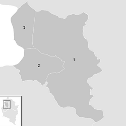
The Dornbirn district is divided into three communities , including two municipalities and a market town. This means that the district includes the largest market town in Austria, Lustenau, the largest town in Vorarlberg, Dornbirn, and the youngest town in the state, Hohenems.
The Dornbirn district is congruent with the Dornbirn judicial district and is therefore subject to the jurisdiction of the Dornbirn District Court and the Feldkirch Regional Court .
Communities

The population figures are from January 1st, 2020.
| local community | location | Ew | km² | Ew / km² | Judicial district | region | Type
|
photo | Metadata |
|---|---|---|---|---|---|---|---|---|---|
Dornbirn
|

|
49,872 | 120.83 | 413 | Dornbirn | Rhine Valley | urban community
|

|
According to code: 80301 |
Hohenems
|

|
16,731 | 29.19 | 573 | Dornbirn | Rhine Valley | urban community
|

|
According to code: 80302 |
Lustenau
|

|
23,309 | 22.25 | 1048 | Dornbirn | Rhine Valley | market community
|

|
According to code: 80303 |
Population development

Web links
Individual evidence
- ↑ Statistics Austria - Population at the beginning of 2002–2020 by municipalities (area status 01/01/2020)
Coordinates: 47 ° 25 ' N , 9 ° 45' E