Written stone street
| State road B56 in Austria | |||||||||||||||||||||||||||||||||||||||||||||||||||||||||||||||||||||||||||||||||||||

|
|||||||||||||||||||||||||||||||||||||||||||||||||||||||||||||||||||||||||||||||||||||
| map | |||||||||||||||||||||||||||||||||||||||||||||||||||||||||||||||||||||||||||||||||||||
| Basic data | |||||||||||||||||||||||||||||||||||||||||||||||||||||||||||||||||||||||||||||||||||||
| Start of the street: |
Lockenhaus ( 47 ° 25 ′ N , 16 ° 25 ′ E ) |
||||||||||||||||||||||||||||||||||||||||||||||||||||||||||||||||||||||||||||||||||||
| End of street: |
Güssing ( 47 ° 4 ′ N , 16 ° 20 ′ E ) |
||||||||||||||||||||||||||||||||||||||||||||||||||||||||||||||||||||||||||||||||||||
| Overall length: | 64.5 km | ||||||||||||||||||||||||||||||||||||||||||||||||||||||||||||||||||||||||||||||||||||
|
State : |
|||||||||||||||||||||||||||||||||||||||||||||||||||||||||||||||||||||||||||||||||||||
|
Course of the road
|
|||||||||||||||||||||||||||||||||||||||||||||||||||||||||||||||||||||||||||||||||||||
| State road B56a in Austria | |||||||||||||
| 56a | |||||||||||||
| Basic data | |||||||||||||
| Start of the street: |
Heiligenbrunn ( 47 ° 2 ′ N , 16 ° 26 ′ E ) |
||||||||||||
| End of street: |
Heiligenbrunn ( 47 ° 2 ′ N , 16 ° 27 ′ E ) |
||||||||||||
| Overall length: | 1.358 km | ||||||||||||
|
State : |
|||||||||||||
|
Course of the road
|
|||||||||||||
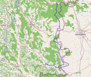
The Geschriebenstein road (B 56) is a country road in Austria . It has a length of 64.5 km and runs in southern Burgenland along the state border with Hungary . The Geschrittenstein Road, named after the highest mountain in Burgenland , begins in Lockenhaus in the Güns Valley and leads over the top of the pass in the Geschrittenstein-Írottkő Nature Park . Then it leads through the valley of the Pinka and the Pinkaboden into the valley of the Strem to Güssing .
history
The Geschrittenstein Strasse in its current form has only existed since 1972 and emerged from numerous former state roads.
Origins
Since Burgenland belonged to Hungary until 1921 , all roads were oriented towards the Hungarian cities of Körmend and Szombathely. The road from Burgau via Güssing to Körmend was classified as a Hungarian state road in 1854. In 1926 the road network in Burgenland was reorganized and adapted to the changed state borders. The following state roads have been on today's route since July 1, 1926:
- The stretch between Güssing and Körmend was called Güssinger Straße .
- The Pinkatalstraße branched off in Strem and led via Moschendorf and Edlitz to Kohfidisch.
- The Rechnitzer Straße between Rechnitz and Schachendorf had also been part of the network of regional roads in Burgenland since July 1, 1926.
The Burger Straße or Deutsch-Schützener Straße in between was declared a district road by an ordinance of the Burgenland state government of August 20, 1928.
Previous routes and names
The Kirchschlager road led as a national highway of Lockenhaus over the Geschriebenstein to Schachendorf since April 1, 1948th Since 1972, Kirchschlager Strasse has ended in Rattersdorf, which is why the southern section of Kirchschlager Strasse was renamed Geschrittenstein Strasse ( B 56 ) in 1972.
The Geschrittenstein Strasse between Schachendorf and Güssing has only been part of the network of federal roads in Austria since January 1, 1972 . It replaced the state and district roads mentioned above.
Web links
swell
- ↑ Spelling according to the regional road ordinance of Burgenland , current version published in LGBl. No. 2/2018
- ^ Directory of the state and state roads in the Pressburger, Oedenburger, Kaschauer and Großwardeiner administrative areas. LGBl. No. 19/1854, p. 113.
- ↑ Law of January 15, 1926, regarding public roads with the exception of federal roads (Road Administration Act for Burgenland), LGBl. No. 25/1926.
- ↑ Ordinance of the Burgenland provincial government of August 20, 1928, regarding the declaration of roads as district roads, LGBl. No. 57/1928.
- ↑ Announcement of the Federal Minister for Buildings and Technology dated February 7, 1974 in accordance with Section 33 (4) of the Federal Roads Act 1971 with regard to the Province of Burgenland, Federal Law Gazette No. 129/1974.
| B56 | The Geschrittenstein Straße was, like the other former federal highways, in the federal administration. Since April 1, 2002, it has been under state administration and continues to have the B in the number, but not the name Bundesstraße. |
