
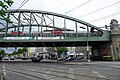
Vienna suburbs street
| State road B222 in Austria | |
| 222 | |
| Basic data | |
|
State : |
|
| Development condition: | downgraded to community road |
The Viennese suburbs street is a street along the suburban line in Vienna. It belonged to the network of federal highways in Austria from September 1, 1971 until the end of 1993 and was numbered B 222 . On January 1, 1994, the street was deleted from the Federal Roads Act and taken over by the City of Vienna as a municipal street without a number.
Route

The B 222 led in increasing kilometers (from north to south) from the Brigittenau junction from the Gürtel (B 221) at Adalbert-Stifter-Straße through the western and northern districts 20 (Lorenz-Müller-Gasse), 19 (Gunoldstraße, Barawitzkagasse, Ruthgasse, Silbergasse, Billrothstraße, Krottenbachstraße, Hans-Richter-Gasse, Peter-Jordan-Straße), 18 (Max-Emanuel-Straße, Hasenauerstraße, Gersthofer Straße), 17 (Lidlgasse, Richthausenstraße, Gräffer- or Dittersdorfgasse, Julius -Meinl-Gasse), 16 (Julius-Meinl-Gasse, Lobmeyrgasse, Sandleitengasse, Maroltingergasse), 14 (Maroltingergasse, Leyserstraße, Ameisgasse) and via Cumberlandstraße to the Unterbaumgarten / Unter Sankt Veit area at the intersection with the B 1 (Hadikgasse / Zehetnergasse). There was no extension to Altmannsdorf along the connecting railway and via Speising to Hetzendorf , which was planned in the 1980s , but neither was it dismantled as a result of the criticism. Most of the former federal highway still exists as it was originally.
Criticism and inheritance

The route of the B 222 was controversial from the start, as it mostly leads through densely populated residential areas and cross-district through traffic into it. Since it crosses the traditional settlement axes of the western districts as a tangential connection, which are usually oriented radially towards the city center, traffic light crossings had to be established in some places in order to regulate the meeting of motorized individual traffic and pedestrian traffic from several directions. The high frequency at these intersections usually had a negative effect on the spatial context of the districts affected, as long waiting times were incurred for pedestrians and the through traffic that was brought into the district centers and residential areas also worsened the traffic safety situation. The business function of the affected areas was weakened as a result, as is complained about for Gersthof . A citizens' initiative was formed there that wants the four-lane expansion in the center of the district to be reversed. In the nearby cottage area, too, residents resisted the through traffic that the former B 222 brought into the posh residential area. For the section around the Hernals train station , MA18 found that the intersection with Hernalser Hauptstrasse was actually too complex, which would result in unusually long waiting times for passers-by. Another citizens' initiative was formed around the nearby Schadinagasse against the crawl traffic caused by the Wiener Vororte Straße through the actually traffic-calmed residential area. The Hernals district parliament also dealt with the sneaking traffic on Beringgasse . In Penzing , the Grätzlin initiative in the Matznerviertel is concerned with the effects of the former federal highway on traffic safety.
The strategic requirements in the urban development plan STEP2025 adopted by the Vienna City Council in 2014, including the mobility concept, could now lead to a further adaptation of sections along Vienna's suburbs street (after the legal downgrading in 1993) . Departing from post-war traffic planning, the community sees the creation and strengthening of district centers around traffic junctions with underground and suburban train connections as an instrument for realizing the ideal of a "city of short distances" and wants motorized individual transport to contribute to mobility in the urban area to 20% by 2025.
gallery
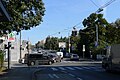
Intersection of Hernalser Hauptstrasse and Wiener Vororte Strasse .

In front of the Kongressbad , Julius-Meinl-Gasse.
Past the Lidlpark to Gersthof .

Area at the intersection of Ottakringer Straße and Sandleitengasse.


swell
- ^ Announcement by the Federal Minister for Buildings and Technology of October 17, 1973 in accordance with Section 33 (4) of the Federal Roads Act 1971 with regard to the State of Vienna, Federal Law Gazette No. 545/1973 .
- ↑ Federal Highway Law Amendment 1993 Federal Law Gazette No. 33/1994 .
- ↑ http://www.wien.gv.at/recht/landesrecht-wien/rechtsordnung/html/v0011150.htm
- ↑ Ordinance: Road course of the federal highways in Vienna, Federal Law Gazette No. 390/1987
- ↑ https://www.wien.gv.at/stadtentwicklung/projekte/verkehrplanung/strassen/bundesstrassen/bundesstrassen-1986.html
- ↑ http://www.parlament.gv.at/PAKT/VHG/XVI/A/A_00197/imfname_270329.pdf
- ↑ http ://www.mein Bezirk.at/wien-18-waehring/politik/gersthof-rueckbau-vom-tisch-d607753.html
- ↑ http://www.cottageverein.at/Inhalte/Main_Verkehrsberuhigung.php?o=6&u=3&id=2
- ↑ https://www.wien.gv.at/stadtentwicklung/studien/pdf/b008173a.pdf
- ↑ http://www.ots.at/presseaussendung/OTS_20140306_OTS0114/fpoe-hernals-zu-schadinagasse-buergerwunsch-vor-umsetzung
- ↑ http ://www.mein Bezirk.at/wien-17-hernals/chronik/schleichweg-beringgasse-vor-dem-aus-d1079559.html
- ↑ http://matznerviertel.at/ueber-uns
- ↑ https://www.wien.gv.at/stadtentwicklung/strategien/step/step2025/