
Hernals
|
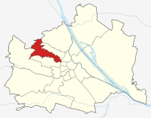
Hernals XVII. Viennese district |
|
|---|---|
| coat of arms | map |
 |
 .svg) |
| Geographic location : | 48 ° 14 ' N , 16 ° 17' E |
| Surface: | 11.35 km² |
| Residents: | 57,027 (January 1, 2020) |
| Population density : | 5024 inhabitants / km² |
| Postal code : | 1170 |
| Address of the district office: |
Elterleinplatz 14 1170 Vienna |
| Website: | www.wien.gv.at |
| politics | |
| District Head : | Ilse Pfeffer ( SPÖ ) |
|
District council election 2015 |
A total of 40 seats |
| Map: Hernals with parts of the district | |

|
|
Hernals is the 17th district of Vienna . It was formed in 1892 from the independent communities Hernals , Dornbach and Neuwaldegg and today has 57,546 inhabitants (2018). The district is particularly valued by its residents because of its proximity to the city center ( university and town hall district , old and new general hospital ) and to local recreation areas ( Schwarzenbergpark , Schafberg , Kongresspark and -bad ). Hernals is characterized by a strong demographic mix, which is reflected in the diversity of the districts. In the district, for example, there are quarters characterized by the late and late founding era, next to communal residential complexes, cottage areas and old town centers.
geography
.jpg)

.JPG)
location
The Hernals district is located in the northwest of Vienna's urban area in the transition area between the Alps and the Vienna Basin . Hernals covers 11.35 km² and is the tenth largest municipal district in Vienna. Hernals takes up 2.7% of the area of Vienna. The district extends along the course of the now canalized Als between the Vienna Woods and the Gürtel . After the Vienna River, the Als is the second longest brook that flows from the Vienna Woods into the Danube. The highest point in the district is the Heuberg at 464 meters, a well-known weather corner . Hernals has several ecological protected areas. The landscape protection area Hernals covers 5.93 km² in the Vienna Woods and occupies 52.3% of the district area. Smaller, so-called ecological development areas, are on the Franz Glaser-Höhe and in the Stefan-Zweig-Platz / Korngasse area.
Today the district is characterized by great differences between its eastern and western parts. While the eastern, central parts of the district ( Hernals and the adjoining Dornbacher Frauenfeld ), which take up around three quarters of the district's population in one sixth of the district area, are characterized by Wilhelminian-style buildings and high population density, the western part ( Dornbach , Neuwaldegg , Heuberg) has residential areas, old village centers and community buildings in a quiet green area, sometimes also vineyards.
The main traffic and development axis of the district is the Hernalser Hauptstraße , which goes back to a Roman traffic route , which is called Dornbacher or Neuwaldegger Straße in the further course in the direction of the Wienerwald and which flows into the L120 to Tulln . The borders with the neighboring districts of Währing and Ottakring often run through densely built-up areas, especially in the central area.
Neighboring districts and municipalities
The Hernals district borders the Lower Austrian municipality of Klosterneuburg in the northwest . In the west, Hernals borders on the 14th district, Penzing , with the district border running along the Dornbach and Amundsenstrasse. The southern district border opposite the 16th district, Ottakring , is initially in the forest area between Heuberg and Gallitzinberg and then runs in an easterly direction through built-up area to the Gürtel, the Hernals in the east from the 8th district, Josefstadt , and from the 9th district, Alsergrund , separates. In the north, the district border runs across from the 18th district, Währing , through densely built-up areas and along the ridge of the Schafberg. In the north-west, Hernals also borders on the 19th district, Döbling , or its district Salmannsdorf .
There have been five minor changes to the district boundaries since the 1990s. In 1990 the border with Währing was moved in the area between Czartoryskigasse and Herbeckstraße, which meant a small loss of territory for Hernals. In 1992, Hernals acquired a small, undeveloped area from the Ottakring district in the area of Savoyenstrasse, Wilhelminenstrasse and Oberwiedenstrasse. In 1995, Hernals von Währing received a residential area in the Höhenstraße, Keylwerthgasse and Salmannsdorfer Straße area, and in 1998 the border to Ottakring (in the Spinozagasse area between Steinmüllergasse and Rosenackerstraße) was shifted a bit to the north. The last boundary change so far took place in 2001 in the area of the congress park, which has since been entirely in the Ottakringer area.
District parts
The originally independent suburbs of Hernals, Dornbach and Neuwaldegg were incorporated in 1892 and today form the 17th district. The boundaries of the former communities are still preserved today within the boundaries of the three existing cadastral communities of the same name, with Hernals occupying the densely built-up east and Neuwaldegg the wooded northern part of the district area. Dornbach, which occupies the southwest of the district area, consists of a more densely built-up area in the east and the forest area of the Heuberg in the west.
There is also a breakdown of the district area into the counting districts of the official statistics, in which the counting areas of the municipality are summarized. The six counting districts in Hernals are Dornerplatz, Alt-Hernals, Äußere Hernalser Hauptstraße, Alszeile, Dornbach and Neuwaldegg. However, the boundaries of the Dornbach and Neuwaldegg census districts do not match those of the cadastral communities of the same name. The census district Äußere Hernalser Hauptstrasse is located on both sides of the border between the cadastral communities Hernals and Dornbach, which runs roughly in the area of the suburb line.
Land use
The construction area of Hernals comprises 29.7% (Vienna-wide 33.3%) of the district area. The share of residential building space in total building land is 90.9% (second highest share in Vienna). Accordingly, the proportion of industrial building areas (2.8% of the building area) and areas used for cultural, religious, sporting or public areas (5.4%) is low.
Green spaces in Hernals take up 59.6% of the district area, making Hernals the third greenest district. 66.5% of the green space is accounted for by forests, 12.1% by meadows and 11.4% by allotment gardens. Sports and leisure areas (3.7%) and agricultural areas (2.4%) only make up a small part of the Hernals green areas. The once important wine-growing region has disappeared apart from one last remnant on the Kleiner Schafberg.
The proportion of traffic areas in the district area is very low at 10.3%, water bodies take up 0.4% of the district area.
| Construction area | Green space | Waters | Traffic areas | |||||||
|---|---|---|---|---|---|---|---|---|---|---|
| 336.9 | 675.91 | 4.01 | 117.01 | |||||||
| Housing | Service area | public facilities | Agriculture | Parks | Woods | grasslands | Allotments | Leisure areas | ||
| 306.11 | 9.55 | 18.25 | 15.88 | 27.21 | 449.4 | 76.88 | 81.48 | 25.05 | ||
history
The Becoming of a Metropolitan District (1892–1914)

The 17th district of Vienna, Hernals, was created through the incorporation of the previously independent suburbs of Hernals , Dornbach and Neuwaldegg , which was decided by the Lower Austrian state parliament in 1890 and came into effect on January 1, 1892 , the history of which is dealt with in the relevant lemmas up to the unification with Vienna .
The longitudinal shape of the district created in 1890 in a west-east direction (74,657 inhabitants) corresponds to the traditional settlement axis along the Als and its tributaries, which, however, gradually disappeared from the townscape after 1870 due to bulges. The suburb of Hernals was not only by far the most populous of the three incorporated and therefore named after it, but with 70,933 inhabitants it was also the largest municipality in Lower Austria after Vienna. However, it had long since grown together with the similarly populous neighboring communities Ottakring, Neulerchenfeld (both now 16th district) and Währing (now 18th district) to form a suburb agglomeration that numbered almost a quarter of a million inhabitants.
After the incorporation, the settlement gaps between Hernals and Dornbach were closed by the construction of apartment buildings in the late founding period between Rosensteingasse and Güpferlingstrasse. This created a new, densely populated part of the city (Outer Hernals) on both sides of a main street designed as an avenue, the spatial and structural structure of which differs from the inner Hernals (also: Alt-Hernals), which was characterized by the early and high-founding era.
Other major innovations in the metropolitan district of Hernals at the turn of the century included the demolition of the line wall, the demolition of well-known entertainment establishments in its vicinity in favor of the expansion of the belt boulevard and the construction of the belt line of the Vienna steam light rail (from 1925 Vienna electric light rail , today U6), the construction of the Suburb line (formerly the steam light rail, today S45), the relocation of the Hernalser Markt to today's Zimmermannplatz (9th district) and the opening of the first municipal indoor swimming pool ( Jörgerbad ).

Red Vienna, Fascism and Reconstruction (1918–1955)
During the reign of the Social Democratic Workers' Party in the so-called Red Vienna , municipal housing construction was particularly promoted in Hernals after the First World War . In 1922, the first municipal building with 164 apartments was built in Balderichgasse , based on a design by Karl Ehn . The largest municipal building erected in Hernals in the interwar period was the one handed over in 1929 in the northern area of Wattgasse with 294 apartments. Also known for their remarkable architecture are the Wiedenhoferhof on Kongressplatz , built in 1924/1925 according to plans by Josef Frank , and the Holyhof ( 1928/1929 ) by the Wagner student Rudolf Perco . Due to the financial pressure of the federal government , residential construction finally fell sharply; the proportion of municipal apartments in Hernals remained below the Viennese average at 1,467 apartments.
After the Schattendorfer verdict , riots broke out in Hernals too, on July 15, 1927, the police station in Hernalser Hauptstrasse 158 was stormed by angry demonstrators. They dragged the inventory of the guardroom into the street and set it on fire. Two avenue trees that were affected by the fire were later tended as revolutionary trees , but died in the mid-1930s. The riots continued on June 16, when five people died in Hernals that day.
The February fights in 1934, however, took place away from Hernals. However, the ban on the Social Democrats made the district council obsolete and the corporate state dictatorship appointed a new district head. From March 1938 onwards, during the Nazi era, the deprivation of rights, robbery, expulsion and deportation of the Jewish Viennese took place in Hernals and throughout Vienna . Deportation to the east was often followed by murder.
The Second World War ended in Hernals with the invasion of the Red Army on April 7, 1945. Soviet soldiers stayed in Hernals until the end of August 1945, and on September 1, 1945 they were relieved by American occupation troops . In addition to the reconstruction of the destroyed houses, the main focus was on building new apartments. By 1955 alone, 1,050 communal apartments were allocated in Hernals, and by 1991 2,948 additional apartments were added.
Hernals since 1955

In the post-war period, the mass motorization and its concomitants led to a dramatic devaluation of the Wilhelminian-era district west of the belt . In connection with suburbanization and the influx of mostly low-income immigrants into worn-out substandard apartments, this led to the perception of this urban region as an urban problem zone. The Hernalser Hauptstraße, the most important shopping street and traditional local supply center for the Hernalser, also began to suffer from the change in consumption and mobility, which was reflected in an increasing number of empty shops.

Since the 1980s, however, positive developments have been recorded in some areas. In the cultural field, the opening of the Kulisse and Metropol venues brought impulses that were perceived throughout the city and at least put the reputation of Hernals as a cultural desert into perspective. The area around Elterleinplatz benefited in the same decade from the construction of a 'district center' based on plans by the well-known architect Harry Glück . Opened in 1986, it combines an administrative building, adult education center, municipal library, a shopping center at ground level, an underground car park and 111 community apartments in one block. For the rear parts of the district, however, the reanimation (1987) of the suburban line of the Vienna Stadtbahn as the S45 suburban railway had a positive effect, especially since the connection to the U3 via the nearby station Vienna-Ottakring, which was made possible in 1998 . In the same area, there has since been a concentration due to mostly private construction activity (with the exception of the Bruno-Kreisky-Hof), which accompanies the de-industrialization of this formerly functionally mixed area on the edge of Vienna's core city.

At the turn of the millennium, a change started in the western belt area as well, triggered by extensive regeneration projects, a not inconsiderable part of which was borne by EU funds. An art and local scene established itself in the belt arches of the Stadtbahn , in the Yppenplatz district and along Ottakringer Straße , which made the area interesting for alternatives as well as young people with a migration background from the former Yugoslavia. The rise in housing costs associated with this upgrade first made itself felt in the neighboring Ottakring, and most recently in the neighboring Hernals, whose image as a shabby outskirts is now changing. In connection with the re- urbanization of Vienna, which has led to a revitalization of the inner districts in the last few decades (and to an associated socio-economic polarization), Hernals is also winning because of its proximity to the center, good public transport connections, its proximity to local recreation areas and comparatively moderate ones Housing costs in popularity.
The important traffic junction Elterleinplatz (together with Bartholomäusplatz around the Kalvarienbergkirche called 'Central Hernals') and the area surrounding the Vienna-Hernals train station were redesigned in 2008/10 and 2014/5. In the near future, both transport hubs will also benefit from a connection to the underground network (U5 station Elterleinplatz) or an extension of the S45 to the important urban development area along the Handelskai (see Donau City and Campus WU ). The positive developments of recent years should not hide the fact that structural problems have not been resolved. Hernalser Hauptstrasse, for example, has only managed the balancing act between the central district shopping street and the arterial road, which is characterized by through traffic, to a limited extent for a long time. The high volume of traffic along this main axis of the district is also due to the poor quality of stay in public spaces. In the central Hernals area, there is also an acute shortage of green and local recreational spaces. The overloading of tram line 43, which connects the Vienna Woods with the city center along the main axis of the district, can only be reduced temporarily by increasing the number of times.
population
Population development
Source: Statistics.at

Population development
When it was formed at the end of the 19th century, the Hernals district had 74,696 inhabitants. By 1910 the population grew by over 60 percent to 103,000. As a result, however, the population began to shrink, which lasted until 2001. Only in the 1980s there was a slight population increase in Hernals, but until the last census in 2001 the resident population shrank again to 47,610. Since 2001, as in the other districts, population growth has been recorded. The MA18 (urban development and urban planning) predicts a population development from 50,867 people (2005) to 65,589 (2035), i.e. an increase of 14,722, which could primarily take place in the Wilhelminian-style districts between the Gürtel and the suburbs. At the beginning of 2015 the population was 55,536.
Population structure
The population structure in Hernals largely reflects the Viennese average. 21.4 percent of Hernalser are 60 years of age or older, 52.8 percent of the population are female. At 28.8 percent, however, the proportion of foreigners in the district's population is significantly higher than the Viennese average. According to the 2001 census, the highest proportion was made up of citizens from Serbia and Montenegro at 33.9 percent , followed by Turks (14.7 percent) and Bosnians (9.7 percent).
Of the 40,665 residents of Hernals who were over 15 years old in 2001, 12.6 percent have completed a university , technical college or academy as the highest level of education (Vienna-wide: 11.8 percent). Another 15.6 percent have completed a high school diploma (Vienna-wide: 15.7 percent), 35.5 percent had an apprenticeship qualification or a vocational middle school (Vienna-wide: 39.2 percent) and 36.3 percent of Hernalser have compulsory school as the highest Graduation (Vienna-wide: 33.2 percent).
The average annual net income of an employee in 2004 was 17,768 euros (Vienna: 18,489 euros), that of a pensioner was 16,600 euros (Vienna: 16,412 euros). The male population earned 19,940 euros net (pensioner: 19,780 euros), while the female population earned only 15,329 euros net (pensioner: 14,531 euros). Overall, the income of employees in Hernals is around four percent below the Viennese average, and that of pensioners just above it.
religion

The religion of the Hernalser is distributed as follows: 47.4 percent are Roman Catholic , 23.4 percent without religion , 9.4 percent Orthodox , 9.4 percent Islamic , 4.1 percent Protestant . The four Roman Catholic parishes in the municipality form the city dean's office 17 .
Before 1938 there was a small Jewish community in Hernals. Although there was no synagogue, there was the Gemilath Chesed (“Man exercise grace”) association at Thelemangasse 8, which was founded in 1929. The chairman was Julius Krupnik and the rabbi Markus Leib Habermann. The club house, like all other Jewish institutions, was closed by the Nazis and the community members were either forcibly emigrated or deported and murdered. Today the small Sultanahmet mosque is located in Thelemangasse 8 .
The building at Thelemangasse 8 and house numbers 2, 4, 6 were owned by the hardware manufacturer Mandelbaum, who had to flee to England in 1940. The grandson of the founder Bernhard Mandelbaum is the American author Frederic Morton (born as Fritz Mandelbaum), who grew up in Thelemangasse 8 and attended secondary school BRG 17.
politics
| District chairman since 1945 | |
|---|---|
| Alois Brunner ( KPÖ ) | 4 / 1945-1946 |
| Leopold Pernerstorfer ( SPÖ ) | 1946-1949 |
| Karl Panek (SPÖ) | 1949-1965 |
| Josef Veleta (SPÖ) | 1965-1979 |
| Robert Pfleger (SPÖ) | 1979-1997 |
| Hans Mentschik (SPÖ) | 1997-2002 |
| Ilse Pfeffer (SPÖ) | since 2002 |

Hernals was ruled by the Christian Social Party at the turn of the 19th to the 20th century through the curial suffrage . Franz Helbling, the last mayor of Hernals, was elected district chairman in 1891 . In the first general election, however, the Social Democrats in Hernals won an absolute majority with 58 percent, ahead of the Christian Socials (27 percent) and the Czech-Slovak Social Democrats. These conditions remained essentially until 1932, but the Czechoslovaks disappeared and the National Socialists increased to 17 percent in 1932 at the expense of the Christian Socials. The social democrat Anton Haidl dominated the district as district head from 1919 to 1934.
In the first elections in November 1945, the SPÖ regained an absolute majority with 57 percent and is still the district chairman today. However, with the rise of the FPÖ in the 1990s, the supremacy of the SPÖ melted more and more. While the SPÖ was around 43 percent in 1991, its share of the vote fell in 1996 to 33.4 percent. The FPÖ was now just behind with 28.46 percent (+ 6.27).
Elections 2001:
This trend was reversed in the 2001 elections. The SPÖ reached 39.90 percent, the FPÖ 20.81 percent. The ÖVP was just behind with 19.54 percent. The Greens , who came to 15.31 percent, were able to gain significantly.
2005 elections :
In the district council elections on October 23, 2005, the SPÖ achieved 41.14 percent (+1.19 / 17 seats). The ÖVP got 21.82 percent (+2.82 / 9 mandates) and again provides the district chief deputy. The Greens got 18.44 percent (+3.13 / 8 seats). The FPÖ lost 6.17 percentage points and is now 14.46 percent (6 mandates). The Liberal Forum , with 1.49 percent (−2.17), just like the BZÖ , which received 1.06 percent, and the KPÖ with 1.42 percent (+0.82) did not make it into the district council.
Elections 2010:
In the district council elections on October 10, 2010, the SPÖ lost 3.8 percentage points and is now 37.3 percent (16 seats). The ÖVP lost 4 percentage points as well as the district chairman's deputy and is now 17.8 percent (7 mandates). The Greens got 20.3 percent (+1.9 / 8 seats). The FPÖ gained 6.1 percentage points and is now at 20.7 percent (9 mandates) and is again providing the district councilor deputy. The Liberal Forum achieved 1.1 percent (−0.4) just like the KPÖ with 1.4 percent (+/-) and the BZÖ, which this time increased to 1.4 percent (+0.3), not that Moving into the district council.
Elections 2015:
In the 2015 BV election, the SPÖ received 8,614 votes (+233 compared to 2010, 34.1%), the FPÖ 5928 (+1280, 23.4%), the GREEN 5012 (+451, 19.8%), the ÖVP 3155 (−834, 12.5%), and also the NEOS made it into the district parliament with 1822 votes (7.21%). 756 eligible voters (3%) voted for parties that did not achieve this goal. In the simultaneous elections to the municipal council, in which 7195 district residents were less entitled to vote, the SPÖ (37.7%) and FPÖ (25.9%) in Hernals received more support and the GRÜNE (15.7%) and ÖVP (11.7%) less support than at the district level. With the NEOS the difference was insignificant (7.5%).
coat of arms
The Hernals coat of arms is divided into three parts and represents the three former independent municipalities of Hernals , Dornbach and Neuwaldegg .
- The upper half of the coat of arms is dedicated to Hernals and shows a blue bunch of grapes on a red background. The coat of arms of Hernals stands for the former livelihood of the Hernals wine growers .
- The lower left part of the coat of arms represents Dornbach with two silver, crossed keys on a gold background. The keys symbolize the Benedictine - Abbey of St. Peter in Salzburg, the basic rule held over Hernals.
- The lower right side is in turn dedicated to Neuwaldegg, with the depicted house with two trees on a green meadow with a path symbolizing the former manor house .
Culture and sights


Attractions
The most important ecclesiastical sights in Hernals are the Calvary Church and the Redemptorist Church . There is also the Jörgerbad , the sports club square (on Frauenfeld in Dornbach) and the Alszauberbrunnen with statues of a Schrammel quartet. In the Dornbach district , the Dornbach parish church , the Sacred Heart of Jesus Church and the St. Anna Chapel are worth mentioning; in Neuwaldegg the Neuwaldegg castle and the Black Mountain Park .
theatre
The founding of theaters in Hernals had little success in the past. For the Josefstädter Theater , which was closed in the revolutionary year 1848, a summer theater was founded in Hernals, the First Vienna National Arena. After a few years, however, the theater was closed. The Dornbacher Theater, founded in 1966, also had to close after only six months.
There were also smaller theaters in the interwar period , for example a farmer's stage on the corner of Dornbacherstraße / Vollbadgasse, which was taken over in 1948 by the Theater in Dornbach, an operetta stage . Despite sold out performances, the theater had to close a year later due to financial problems. Today Hernals is home to two important and well-known theaters. Musicals, concerts and cabarets are performed in the traditional Viennese Metropol , while the setting is purely a cabaret theater .
Museums
The Hernals District Museum (Hernalser Hauptstrasse 72-74) is dedicated to the history of the district. The focus is on the Schrammel brothers, the Kalvarienbergkirche, the formerly important viticulture, the sieges by the Ottomans, the special role of Hernals in Protestantism and Neuwaldegg Castle and Park. On the occasion of the 200th anniversary of his death, a permanent special exhibition was set up for Field Marshal Franz Moritz von Lacy in 2001 . The Vienna Snow Globe Museum (Schumanngasse 87), the Fiaker Museum (Veronikagasse 12) and the Vienna Rescue Museum (Gilmgasse 18) are also located in the district area.
Contemporary art
The places of art creation and consumption in Hernals include the atelier houses in Wattgasse, Steinergasse and Thelemangasse as well as Mo.ë Vienna and the art space Ewigkeitsgasse (both in the Yppenplatzviertel , where the AU and Brunnenpassage event centers are located in the immediate vicinity of the district boundary ) . The arteum at the Hernalser Friedhof sees itself as a center for sculpture in Vienna. A cultural network in Hernals (KNH) was founded in 2011 as a platform for sustainable cultural networking in the district. The contemporary art festival SoHo in Ottakring , known beyond the city limits, has been taking place in Sandleiten since 2014 , right on the district border with Hernals.
Economy and Infrastructure
traffic

The suburban line (S45), which has a stop in the district with the Vienna Hernals station, runs through Hernals in the Vienna S-Bahn network . Immediately across the border to the 9th district is the Alser Straße underground station on the U6 line . The U5 , which is to connect the Hernalser Elterleinplatz with the Karlsplatz via the current U2 route , will be built from 2018. Hernals is also connected to the public transport network by tram and bus lines. Hernalser Hauptstrasse acts as the main traffic artery .
In the far east of the municipality is a multi-lane section of the street of the belt . The Höhenstraße , which runs through the mountains of the Vienna Woods, begins in the Neuwaldegg district . Wattgasse, which connects Hernals with Schönbrunn Palace and the Wiental via the Schmelz , is also an important north-south connection.
Health and sport

The only hospital in Hernals is the Divine Savior Hospital founded in 1935 by the Congregation of the Sisters of the Divine Redeemer . The district also has three pools: the Schafbergbad (outdoor pool), the traditional Jörgerbad , built in 1914 in the local style, and the privately run Neuwaldegger Bad (outdoor pool) on the edge of the Vienna Woods. With the Post Sports Field and the Marswiese Sports Center , Hernals offers two locations for recreational sports.
economy

Only a few of the numerous industrial and commercial enterprises that had formed in the course of industrialization in the district have survived. These were mainly the food industry , manufacturing and light industry . Today there are still 350 to 400 companies located in Hernals. In total there are 2,221 workplaces with 18,000 jobs in Hernals. Two thirds are in the service sector , 23 percent in trade and industry and 8 percent in the construction industry . Only 120 people are still active in what was once important agriculture ( viticulture ). Almost half of the workplaces in Hernals have four or fewer employees. The only two companies with over 500 employees are the Manner confectionery factory and the Göttlicher Heiland hospital , which with 700 employees is now the largest employer in the district. The main shopping street is the almost 3 kilometer long Hernalser Hauptstraße .
Streets and squares
The most important street in the Hernals road network is Hernalser Hauptstraße . Together with other streets in the area of the Alserbach (Jörgerstraße, Dornbacher- and Neuwaldegger Straße and Alszeile west of Vollbadgasse) it forms the main traffic and development axis of the district. Between the belt and the sports club stadium , it also fulfills the function of the most important shopping street in the district (in front of Elterleinplatz in conjunction with Jörgerstraße). According to this, Kalvarienberggasse , which crosses Hernalser Hauptstrasse in the area of Elterleinplatz, and Ottakringer Strasse on the border with the southern neighboring district in Hernalser business life are important. In Wattgasse , which connects Hernals with Schönbrunn , the traffic function predominates. In Outer Hernals there is an unusually high proportion of streets in the densely built-up area for Vienna, which are designed as avenues with lateral rows of trees (outer Hernalser Hauptstraße, Heigerleinstraße, Roggendorfergasse, Alszeile, Zeillergasse, Güpferlingstraße).
The most important squares are Elterleinplatz , which is considered the center of Hernals and is located in the immediate vicinity of Bartholomäusplatz in front of the Kalvarienberggirche, as well as Rupertusplatz in Alt-Dornbach , which is still reminiscent of a village square, and the forecourt of Vienna-Hernals train station, which is important as a traffic junction in the center of the district . Not far from the train station are the rectangular Leopold-Kunschak-Platz in front of the Hernalser Friedhof and the semi-oval Dr.-Josef-Resch-Platz (formerly Frauenfelderplatz ) near the Atonement Church, two rather unusual spaces designed around 1900 with echoes of the Baroque era. The Dornerplatz on Ganserlberg , which was once used as a marketplace, is often used for events. The Johann-Nepomuk-Berger-Platz , which is mostly in Ottakring, was also used for market purposes in the past. The Clemens-Hofbauer-Platz , the Lorenz-Bayer Platz , the Stöberplatz and the Diepoldplatz are typical rectangular parking spaces in the street grid for the Wilhelminian era.
Parks
Hernals is home to the oldest landscape garden in Austria, the Schwarzenbergpark in Neuwaldegg , which merges directly into the Vienna Woods and covers around 80 hectares . In addition, there are other small parks in Hernals, such as the around 17,000 square meter Lidlpark with numerous Japanese cherry trees. The Alexander-Lernet-Holenia-Park and the Josef-Kaderka- Park in Dornbach and the Pezzlpark in Hernals have less than 10,000 square meters . In March 2019, the district representative meeting decided to rename the Lidlpark to Nöstlinger -Park and the Pezzlpark to Mortonpark .
The Hanslteich is a popular destination for walkers and day trippers. The pond was created around 1920 to extract ice. It is fed by the Alserbach and is surrounded by woods and meadows. It is freely accessible and is used for boating.
The 61,000 m² congress park in Ottakring borders directly on the Hernals area.
District partnerships
Hernals' partner district is the Japanese Fuchū . The ornamental cherries in Lidlpark are a gift from the district partner.
Personalities
The most important artists in Hernals include the musicians Johann and Josef Schrammel , the actors Josef Meinrad and Ewald Balser , the poet Ferdinand Sauter , the writer Frederic Morton , the church musician Josef Venantius von Wöss , the operetta composer Edmund Eysler , the actress Marianne Schönauer , the musician Roland Neuwirth and the musician Hansi Lang . The architect Friedrich von Schmidt , the figure skater Karl Schäfer and the entrepreneur Josef Manner also lived here . The well-known (but fictional) Viennese whore Josephine Mutzenbacher is said to be from Hernals. Christine Nöstlinger also grew up in Hernals, and some of her books are set in Hernals.
See also
literature
- Evelyn Adunka, Gabriele Anderl: Jewish Ottakring and Hernals . Mandelbaum Verlag, Vienna 2020, ISBN 978-3-85476-870-8 .
- Felix Czeike, Walter Lugsch: Studies on the social history of Ottakring and Hernals. Youth and People, Vienna 1955.
- Peter Diem, Michael Göbl, Eva Saibel: The Viennese districts. Your story - your personalities - your coat of arms. Vienna 2002, ISBN 978-3-85223-463-2 .
- Heike Krause, Martin Mosser, Christine Ranseder, Ingeborg Gaisbauer, Sylvia Sakl-Oberthaler: Hernals. The archaeological excavations ( Vienna Archaeological, 12). 2016, ISBN 978-3-85161-153-3 .
- Helmut Kretschmer: Viennese district culture guide: XVII. Hernals. Jugend und Volk, Vienna 1983, ISBN 3-224-16241-4 .
- Carola Leitner: Hernals: Vienna's 17th district in old photographs. Ueberreuter, Vienna 2007, ISBN 978-3-8000-7304-7 .
- Trude Neuhold: Vienna-Hernals. Illustrated book with over 200 historical photos, "Archive Pictures" series from Sutton-Verlag. 2008, ISBN 978-3-86680-349-7 .
- Rudolf Spitzer: Hernals: between belt and Hameau. Mohl, Vienna 1991, ISBN 3-900272-39-5 .
Web links
Individual evidence
- ↑ Statistics Austria - Population at the beginning of 2002–2020 by municipalities (area status 01/01/2020)
- ↑ District council elections 2015
- ↑ Municipal Department 5 (MA5): Protected Areas 2005 ( PDF ( Memento from September 29, 2007 in the Internet Archive ))
- ↑ Law of November 21, 1989 on a minor change in the border between the 17th and 18th district (LGBl. 4/1990), issued on February 2, 1990
- ↑ Law on a minor change in the border between the 16th and 17th district (LGBl. For Vienna 10/1992), issued on March 9, 1992
- ↑ Law on changing the boundaries between the 17th, 18th and 19th districts (LGBl. For Vienna 48/1995), issued on June 23, 1995
- ↑ Law on changing the boundaries between the 16th and 17th districts (LGBl. For Vienna 6/1998), issued on January 30, 1998
- ^ Law on changing the border between the 16th and 17th districts (LGBl. For Vienna 124/2001), issued on December 14, 2001
- ↑ a b Municipal Department 5 (MA5): Types of use by district ( PDF ( Memento from September 29, 2007 in the Internet Archive ))
- ↑ Census of May 15, 2001. Final resident population and number of citizens (with population development since 1869). District of Vienna: Vienna 17th, Hernals , on Statistics.at (PDF, 12 kB).
- ↑ MA18 (ed.), Small-scale population forecast for Vienna 2005 to 2035 (Vienna, 2007), p. 78f.
- ↑ Demographic data 2001 ( PDF )
- ↑ 2001 census ( PDF )
- ^ Income 2004 of the City of Vienna ( PDF ( Memento from September 29, 2007 in the Internet Archive ))
- ↑ Demographic data 2001 ( PDF )
- ↑ DAVID | Jewish places of worship in Vienna before 1938
- ↑ Mag. Petra Stein: Thesis at the University of Education in Linz on the course “Pedagogy in Memory Places” in the winter semester 2008/09 and summer semester 2009 Supervisor: Dr. Christian Angerer and Dr. Werner Dreier written in summer 2009. Accessed on March 10, 2019 .
- ^ Wiener Zeitung | Morton, Frederic: With the power of the stone ( Memento of the original from July 8, 2014 in the Internet Archive ) Info: The archive link was inserted automatically and has not yet been checked. Please check the original and archive link according to the instructions and then remove this notice. , April 28, 2000 (accessed November 18, 2013)
- ↑ Green Hernals: Hernals commemorates Christine Nöstlinger and Frederic Morton . OTS announcement of March 6, 2019, accessed on March 11, 2019.
1., Inner City | 2., Leopoldstadt | 3rd, highway | 4., Wieden | 5th, Margareten | 6., Mariahilf | 7., new building | 8., Josefstadt | 9., Alsergrund | 10., Favorites | 11., Simmering | 12., Meidling | 13., Hietzing | 14., Penzing | 15., Rudolfsheim-Fünfhaus | 16., Ottakring | 17th, Hernals | 18., Währing | 19., Döbling | 20th, Brigittenau | 21., Floridsdorf | 22., Donaustadt | 23rd, Liesing