
Gallitzinberg
| Gallitzinberg | ||
|---|---|---|
 View from the Jubiläumswarte over the Gallitzinberg towards Vienna |
||
| height | 449 m above sea level A. | |
| location | Vienna , Austria | |
| Mountains | Vienna Woods , Northern Alps | |
| Dominance | 1.05 km → Heuberg | |
| Notch height | 16 m ↓ northeast. Wait | |
| Coordinates | 48 ° 13 '17 " N , 16 ° 15' 56" E | |
|
||

The Gallitzinberg , Wilhelminenberg or Predigtstuhl , colloquially Galiziberg (emphasized on the first i), is a mountain in the west of Vienna - Ottakring with, depending on the layout (with or without Jubiläumswarte as a summit), 388 or 449 meters high, mostly in the area this district of Vienna is located. The Vienna districts of Hernals (in the area of Eselstiege and KGV Predigtstuhl) and Penzing also have a share in the mountain.
Surname
The Gallitzinberg, formerly Predigtstuhl, is named after the Russian ambassador in Vienna, Demetrius Michailowitsch Gallitzin , who acquired extensive estates here in the 1780s.
The name Wilhelminenberg comes from the later owner, Wilhelmine Montléart-Sachsen-Kurland (step-in-law of Maria Christina von Sachsen-Kurland ), a patroness in Ottakring (see Wilhelminenspital ). Since the prince's request to rename from Gallitzinberg to Wilhelminenberg was not officially granted, he had panels with the inscription "Wilhelminenberg" attached and thus achieved an indirect name change. Newspaper reports were even initiated to enforce this renaming.
Today all three place names are often used side by side, even long-established Ottakringers and thorough local researchers cannot exactly define the difference between “Predigtstuhl”, “Gallitzinberg” and “Wilhelminenberg” . At least as the namesake of a statistical census district comprising three census districts, the mountain now officially bears the name Wilhelminenberg. The following streets essentially delimit the mountain: Andergasse, Braungasse, Sandleitengasse, Steinhofstrasse, today Johann-Staud-Strasse. Some see a dividing line in the Liebhartstal , through which the Ottakringerbach flows and the Liebhartstalstrasse runs, and only refer to the part of the mountain range south of the Liebhartstal as Gallitzinberg, the north part as Wilhelminenberg; the street Baumeistergasse / Otto-Hölzl-Weg marks the transition from Wilhelminenberg to Predigtstuhl (where, among other things, there is a street and a large allotment garden with well over two hundred parcels bearing this name). The place names “Predigtstuhl”, “Wilhelminenberg” and “Gallitzinberg” are often used in connection with the preposition “am” and then denote the slope of the mountain that slopes east towards the city of Vienna.
Geography, development history and important buildings
The mountain lies in a northeastern branch of the Eastern Alps and is geologically part of the flysch zone , which is composed of quartz and limestone , marl and other sediments . It is dominated by an extensive area of deciduous forest . For a long time the mountain belonged partly to aristocrats such as the Baron von Langendonk, Prince Gallitzin, the Prince Montléart-Sachsen-Kurland or the Archduke Leopold Salvator of Austria-Tuscany , partly from Altottakring wine-growing families, partly from monasteries such as Klosterneuburg Monastery or the Schottenstift. The eastern slope is now loosely built up and with many villas one of the most sought-after and most expensive residential areas in Vienna; the construction of the villa district on the mountain began in the 1870s. On the mountain are the Wilhelminenberg Castle , the Research Institute for Wildlife Science and Ecology , the Kuffner Observatory , the Starchant Church , a Benedictine monastery in Liebhartstalstraße, the Hotel Gallitzinberg, at the foot of the mountain the Ottakringer Friedhof and the Wilhelminenspital . The Jubiläumswarte is located at the summit at 449 meters above sea level. This well-known observation tower is 30 meters high, the top platform of which is approximately 480 meters above sea level. During the Second World War , the Gaugefechtsstand Wien (" Schirachbunker ") was located here - in the area of the Vogeltennwiese by the Jubiläumswarte .
The last of Ottakring's vineyards are on the mountain near Wilhelminenberg Castle and on the border to Penzing on Johann-Staud-Straße. Three brooks arise on the Gallitzinberg, the now canalised Ottakringerbach, which cut into the Liebhartstal over time, the Rosenbach flowing south and the Rotherdbach (Rotherdbachtal between Winterrotherd and Sommerrotherd), over which the Baumeistergasse runs today. In the case of some properties, a brook servant for the municipality of Vienna is entered in the land register for the vaulted brook.
photos


Prince Gallitzin

Jubilee waiting

View from the Ottakringer Friedhof to Wilhelminenberg Castle

Kuffner observatory

Starchant Church
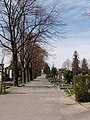
Ottakring cemetery

Montléart mausoleum

Research Institute for Wildlife Science and Ecology


Individual evidence
- ↑ Little Chronicle. (Wilhelminenberg.) In: Wiener Zeitung. (Supplement Wiener Abendpost), September 19, 1883.
- ↑ Christine Klusacek, Kurt tuner: Ottakring. From the Brunnenmarkt to the Liebhartstal. Verlag Mohl, Vienna 1983, ISBN 3-900272-37-9 , pp. 120f.
- ^ Johann König: Around the Galitzinberg. Historical and cheerful stories from Ottakring-Neulerchenfeld. Jacobi, Vienna 1924, p. 5f
- ↑ Alfred Schiemer: In Ottakring's footsteps . Vienna 1999, ISBN 978-3-900799-26-7 , pp. S 54-57, 70, 100-101, 113 .
- ↑ Benedictine Sisters of Adoration: History. Retrieved December 3, 2018 .
Web links
- Entry on Gallitzinberg in the Austria Forum (in the AEIOU Austria Lexicon )
- Wilhelminenberg Castle at www.burgenkunde.at