
Rudolfsheim-Fünfhaus
|
Rudolfsheim-Fünfhaus XV. Viennese district |
|
|---|---|
| coat of arms | map |
 |
 .svg) |
| Geographic location : | 48 ° 12 ′ N , 16 ° 20 ′ E |
| Surface: | 3.86 km² |
| Residents: | 76,813 (January 1, 2020) |
| Population density : | 19,900 inhabitants / km² |
| Postal code : | 1150 |
| Address of the district office: |
Gasgasse 8-10 1150 Vienna |
| Website: | www.wien.gv.at |
| politics | |
| District Head : | Gerhard Zatlokal ( SPÖ ) |
|
District council election 2015 |
A total of 50 seats |
| Map: Rudolfsheim-Fünfhaus with parts of the district | |

|
|
Rudolfsheim-Fünfhaus is the 15th Viennese district and is located west of the city center. Although it is considered to be the outskirts of Vienna because of its location outside the belt , it is in many ways similar to the inner districts: small size, high population density, close to the old town and - unlike the other outskirts - a lack of part of Vienna's green belt . Due to the routing of the Western Railway , the fifteenth is characterized by a strong north-south differentiation. While to the Middle Ages reaching population centers of the former suburbs agglomeration to Fuenfhaus and Rudolfsheim located in the southern part, the northern part (was melting) , which now houses some lives more than half of District residents only after 1850 urbanized. It is probably due to the fragmentation of the district area that no local patriotism has developed in Rudolfsheim-Fünfhaus that would be comparable to that of other outlying districts such as Floridsdorf , Ottakring or Meidling . In recent years, however, there has been a noticeable tendency towards a growing awareness of the Grätzl , for example in the Nibelungenviertel and around Reindorfgasse . In the past it was often associated with worn-out Wilhelminian style districts , labor migration and street prostitution , which has now largely been pushed to the outskirts, but since the turn of the millennium the district has regained its population and attractiveness. Its most famous buildings are the Westbahnhof , the Wiener Stadthalle and the Maria vom Siege church .
geography
Neighboring districts
Rudolfsheim-Fünfhaus is limited as follows:
- North: Ottakring (16th district), border: Gablenzgasse
- East: Neubau (7th district), Mariahilf (6th district), border: Neubaugürtel, Mariahilfer Gürtel, Sechshauser Gürtel
- South: Hietzing (13th district), Meidling (12th district), border: Wienfluss , southern bank.
- West: Penzing (14th district), border from south to north: Schlossallee - Mariahilfer Straße - Winckelmannstraße - Linzer Straße - Johnstraße - Fenzlgasse - Beckmanngasse - Hütteldorfer Straße - Schanzstraße - west of, then on Ibsenstraße
topography
The district area of Rudolfsheim-Fünfhaus was covered by a sea ( Tethys ) during the Mesozoic Era, which retreated 70 million years ago and gradually formed an inland sea ( Paratethys ). After the final retreat of the sea, large masses of debris formed during the Ice Age due to frost, which were mainly transported from the Danube , but also the Vienna River into the Vienna Basin . In the warm-time phases, the Danube and Vienna subsequently cut into the gravel body and formed terraces, the terraces getting older with increasing distance from the waters. Rudolfsheim-Fünfhaus is located in the area of the oldest terrace ( Laaer-Berg-Terrasse ), which extends from Laaer Berg over the Gloriette to Schmelz and Türkenschanze . The Wiental , which once stretched from the Schmelz to the Gloriette, cut its way into this terrace . Due to the ever-decreasing water level, the height gradations arose in today's district area.
The top soil layer in the district consists of a thin layer of loess that has mixed with limestone and sandstone gravel from the Vienna Woods. Underneath are layers of river gravel, especially quartz, which were removed from the Alps. Beneath this layer of gravel are the relics of the freshwater sea, in which layers of sand, gravel and tegel were deposited.
The district area increases from south to north and from east to west. The lowest area is at the crossing Sechshauser Gürtel / Ullmannstraße at an altitude of 184 meters, the highest point at the crossing Johnstraße / Hütteldorfer Straße (240.6 meters).
Waters
In prehistoric times, the Wien River was several hundred meters wide and in Roman times it still formed a wide body of water with many islands. In the Middle Ages and modern times, too, Vienna played a formative role for centuries. On the one hand, the river with its floods repeatedly caused severe damage. On the other hand, the river served as a source of income for many people, both through fishing and through the use of the water for industry or to operate the numerous mills. The largest Mühlbach followed Ullmannstrasse in the Sechshaus part of the district and Mollardgasse in the 6th district . Smaller bodies of water flow into the Vienna, such as the Hollerbach, which is now canalized and whose name was retained in Hollergasse.
District parts


Rudolfsheim-Fünfhaus was essentially formed from the communities Rudolfsheim , Fünfhaus and Sechshaus (the three units continue to exist as cadastral communities ). Over time, the district was expanded to include parts of Gaudenzdorf (between Wienzeile and Diefenbachgasse). The former places Rudolfsheim and Sechshaus and the parts of Gaudenzdorf and Penzing formed what was then the 14th district, Rudolfsheim, until 1938; Fünfhaus remained “independent” as the 15th district. The area between Linzer Strasse in the north, Hollergasse in the east, Linker Wienzeile in the south and Winckelmannstrasse in the west, at that time mainly occupied by two railway stations on Schwendergasse and Sechshauser Strasse and in between with large workshops for city trams, belonged to the 13th District and was not assigned to the new 14th, but to the new 15th district at that time. The Auer-Welsbach-Park (formerly: Schönbrunner Vorpark), adjoining to the west , was moved from the 14th to the 15th district in 1992.
Sechshaus is located in the southeast between Hollergasse, Sechshauser Straße and Diefenbachgasse or Wienfluss. Rudolfsheim is located in the southwest of the district area, Fünfhaus north and east of it, the origin was in the area of Clementinengasse on a connecting path between Gumpendorf and the Schmelz . The border between the districts of Rudolfsheim and Fünfhaus ran on Hütteldorfer Strasse (eastwards from Johnstrasse), Pouthongasse, Schmelzbrückenrampe, Grenzgasse, Mariahilfer Strasse, Geibelgasse and Sechshauser Strasse to the Gürtel. In 1912 part of the Schmelz was still part of the 14th district; in the interwar period, the whole of Schmelz belonged to the 15th district.
After the incorporation, the eastern border of Fünfhaus ran from Bernardgasse (today 7th district) to Stollgasse a block east of the belt, thus through Wimbergergasse and Kenyongasse. Urban-Loritz-Platz was part of the 15th district. The state law of December 28, 1904 (with which the incorporation of Floridsdorf was resolved) stipulated that this district border (as well as others that intersected the belt) was moved to the Gürtelstrasse. In the corresponding announcement by the Lower Austrian governor of June 7, 1905, it was specified that the new border with the 7th district ran along the "western border of the Stadtbahn" and would apply from July 1, 1905.
The former communities of Rudolfsheim and Fünfhaus are also themselves divided into different districts. Rudolfsheim was formed from the communities Rustendorf , Braunhirschen and Reindorf , whose town centers were south of Mariahilfer Straße. The northern part of Fünfhaus north of Hütteldorfer Straße is in turn divided into the Schmelz with the university sports institute and the allotment garden, the east adjacent Nibelungenviertel and the area of Neu-Fünfhaus , which surrounds the two areas.
There is also a breakdown of the district area into the counting districts of the official statistics, in which the counting areas of the municipality are summarized. The seven counting districts in Rudolfsheim-Fünfhaus are Stadthalle, Reithofferplatz, Fünfhaus-Westbahnhof, Sechshaus, Rudolfsheim-Braunhirschen, Rauscherplatz and Schmelz.
Land use
The construction area of Rudolfsheim comprises 52.8% (Vienna-wide 33.3%) of the district area. 81.0% of the building area is residential, which puts the district in the upper range of the Viennese municipal districts. In Rudolfsheim-Fünfhaus, operating areas account for 8.2% of the building area, while cultural, religious, sporting or public building areas make up 10.6%. 33.5% of the district area is accounted for by traffic areas. This establishes the third highest value of a Viennese district. In contrast, the proportion of grassland in the district is rather low. They make up a total of 12.7% in the district. Around half of the green spaces are parks, 31.2% are allotment gardens of the Schmelz, 18.5% are used for sports and leisure areas. Finally, 1.0% is accounted for by waters, i.e. H. the river bed of the Vienna.
| Construction area | Green space | Waters | Traffic areas | |||||||
|---|---|---|---|---|---|---|---|---|---|---|
| 204.04 | 49.16 | 3.68 | 129.46 | |||||||
| Housing | Service area | public facilities | Agriculture | Parks | Woods | grasslands | Allotments | Leisure areas | ||
| 165.35 | 16.62 | 21.59 | 0 | 24.5 | 0 | 15.34 | 0.21 | 9.11 | ||
history
,_Vienna,_Austro-Hungary-LCCN2002708400.jpg)
.jpg)
After the second Turkish siege , the villages of Reindorf (name mentioned for the first time as early as 1411), Braunhirschen (formerly Dreihaus) and Rustendorf , which were united in 1863 to form the community of Rudolfsheim (named after Crown Prince Rudolf ), to the east of which are Fünfhaus and south of Sechshaus . In the 19th century, the entire area was densely built.
In 1890 the three communities were incorporated into Vienna with effect from January 1, 1892, with the Fünfhaus to the east and north forming the 15th district and the former communities Rudolfsheim and Sechshaus the 14th district with the name Rudolfsheim. Under Nazi rule, Rudolfsheim and Fünfhaus were combined to form the 15th district on October 15, 1938, and district number 14 was cleared for Penzing . From 1957 the 15th district was called Rudolfsheim-Fünfhaus.
In the course of the 1848 revolution , after the military had made it impossible for them to march into the city, workers plundered bakeries, butchers and inns in five and six houses. A financial guard at the Mariahilfer Linienamt was murdered. The textile printing factory A. & E. Granichstätten (in today's Pillergasse) was the first of several textile factories to be demolished. After a brandy factory was devastated, the office building on Braunhirschengrund and the police station were destroyed. The arson at the Reindorf parish church was prevented by citizens. When the crowd moved to Schönbrunn Palace the next day , they were gunned down by the military. The reason given for the destruction of textile factories is that textile workers feared for their jobs because of the introduction of machines.
The Israelite gymnastics temple and the stork school existed from 1871 to 1938 , both destroyed or seriously damaged during the November pogroms on November 10, 1938, as did 91 other Viennese synagogues . (Only the building of the city temple in the 1st district survived undamaged that night.) The religious community was then approved by the magistrate to tear down the ruins of the gymnastics temple. In 1938/39 all buildings, apartments and businesses of Jewish owners were confiscated without compensation, and the Jewish residents of the district, insofar as they could not escape, were transported to extermination camps from 1942 onwards. In 2008 a list of the Ariseurs of the 15th district (within its borders before October 15, 1938) was published. The research and exhibition project Herklotzgasse 21 deals with the history of the district's Jewish community .

Westbahnhof 1862

Parade ground Schmelz 1898

Turnergasse synagogue around 1900

The Mariahilferstraße tram station was demolished in 1951

Westbahnhof, Europaplatz 1959
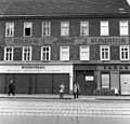
Mariahilfer Strasse 1971


The development of the Schmelz , the large parade and parade ground for the Austro-Hungarian Army until 1918, the construction of the Westbahn , which was opened in 1858 and which was opened in 1858, with the Westbahnhof , one of the city's major traffic junctions, were also essential for the district's history . and the construction of the Vienna Steam City Railway, opened in 1898 , which framed the district in the east and south, was replaced by the Vienna Electric City Railway in 1925 and is now operated as an underground railway . In 1958 the Wiener Stadthalle was opened, Vienna's largest event center. In 1993, the first station of the newly built underground line U3 , a direct connection with the city center, was opened at Westbahnhof . In 1994 the stations at Schweglerstrasse and Johnstrasse followed . Since 1998 it has been possible to drive northwest to the Ottakring terminus .
population
Population development
Source: Statistics.at
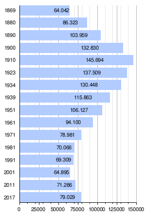
Population development
The current district of Rudolfsheim-Fünfhaus already had 64,042 inhabitants in 1869 and was as densely populated as it is today. As a result of the permanent influx of people into the area, the population grew rapidly and doubled by 1910 to a maximum of 145,694 people. After that, a permanent population decline set in, which is mainly due to higher housing requirements. After a historic low of 64,895 inhabitants in 2001, the district population began to grow again in line with the Vienna-wide trend. At the end of 2017, the population was already 79,029.
Population structure
The age structure of the district population in 2001 was slightly younger than the Viennese average. The number of children under the age of 15 was 15.3%, slightly higher than that of Vienna as a whole (14.7%). The proportion of the population between 15 and 59 years was 65.8% (Vienna: 63.6%), significantly above the average, the proportion of people aged 60 with 19.0% (Vienna: 21.7%) well below. The gender distribution in the district was 48.2% men and 51.8% women, the number of the married population with a share of 40.6% compared to 41.2% was slightly below the average for Vienna.
Origin and language
The proportion of foreign residents in the district was 42.3% in 2017 (Vienna: 29.6%). As in the entire federal state, the share shows growth, in 2001 it was 29.2%. The highest proportion of foreigners in 2005 was made up of around 9.6% of the district population, citizens of Serbia and Montenegro . Another 4.7% were Turkish , 2.5% Polish , 2.3% Croatian , 2.2% Bosnian and 1.1% German citizens. In 2001, a total of 35.2% of the district population was not born in Austria. 13.0% spoke Serbian as the colloquial language , 8.7% Turkish and 5.4% Croatian .
According to a comparative study carried out by MA18 on the use and evaluation of social space in selected Viennese neighborhoods , multiculturalism is evaluated differently in the 15th district than in the 10th district. In Alt- Favoriten, for example, a “pessimistic leading discourse” was found in which immigration is associated with area devaluation and densification, while in Neu-Fünfhaus a “pragmatic-positive leading discourse” is recognizable, “which articulates the perspective of an upgrading process, in the u. a. immigration is described as a positive resource. ”The perception of a“ colorful and attractive urbanity due to the presence of people of different origins and high-quality ethnic infrastructures ”would also be shared by younger people without a migration background in the 15th district . Another key difference, according to the results of the survey, is that in the 15th district, locally significant references are considered more important than supra-regional ones. In contrast, the "tendentially outward-looking view" of the respondents in Alt-Favoriten is much more precarious and susceptible than the inward - looking view of the 15th district, which "focuses more on locally available resources and understands them as potential areas of development."
Creed
Due to the high proportion of foreigners, Rudolfsheim-Fünfhaus has the lowest Roman Catholic population of any district of Vienna with 40.2% (Vienna: 49.2%). There are seven Roman Catholic parishes in the municipality, which make up 15 of the city dean's office . The proportion of people with Islamic or Orthodox beliefs reached 14.7% and 11.4%, the highest values in Vienna. The proportion of Protestant residents was 3.1%, below the average. 23.3% of the district population did not belong to any religious community in 2001, another 7.4% had given no or a different religious denomination.
politics
| Johann Klugmayer ( KPÖ ) | 1945-1946 |
| Heinrich Hajek ( SPÖ ) | 1946-1963 |
| Leopold Mistinger ( SPÖ ) | 1963-1968 |
| Maximilian Eder ( SPÖ ) | 1968-1985 |
| Kurt Menger ( SPÖ ) | 1985-1990 |
| Friedrich Krammer ( SPÖ ) | 1990-1996 |
| Rolf Huber ( SPÖ ) | 1996-2003 |
| Walter Braun ( SPÖ ) | 2003-2008 |
| Gerhard Zatlokal ( SPÖ ) | since 2008 |
The SPÖ has always had a strong majority in Rudolfsheim-Fünfhaus and always provided the district chairman. For a long time, the Social Democrats ruled the district with an absolute majority of votes or seats. In the 1991 elections, the rising FPÖ was able to overtake the ÖVP for the first time , which had traditionally been the second strongest party in the district with the highest proportion of foreigners. In 1996 the FPÖ succeeded in breaking the absolute majority of the SPÖ's mandate with the best result in a Viennese district. In the 2001 elections, however, the FPÖ lost massive votes and even fell behind the 1991 result. The SPÖ and the Greens profited from the losses . The SPÖ achieved a result close to the absolute majority with around 47% of the votes, the Greens rose to the third strongest force with 14% and were able to overtake the ÖVP. In 2005 the trend continued. The SPÖ won easily and reached 49%, the Greens overtook the FPÖ with around 18% and rose to become the second strongest party, which traditionally has a deputy district chairman. The ÖVP remained only the fourth strongest party in 2005, although its share of the vote continued to stagnate.
| year | SPÖ | ÖVP | FPÖ | Green | LIF | BZÖ | Others |
|---|---|---|---|---|---|---|---|
| 1991 | 49.9 | 15.5 | 23.9 | 8.2 | nk | - | 2.5 |
| 1996 | 38.1 | 12.6 | 32.3 | 9.1 | 5.6 | - | 2.3 |
| 2001 | 47.3 | 12.9 | 22.0 | 14.4 | 2.6 | - | 0.9 |
| 2005 | 49.5 | 13.5 | 16.1 | 17.6 | 0.5 | 1.1 | 1.7 |
| 2010 | 43.6 | 9.7 | 23.4 | 19.4 | 0.8 | 1.0 | 2.2 |
In the 2013 National Council elections, 32.94% of those eligible to vote in Rudolfsheim-Fünfhaus voted for the SPÖ (2008: 37.50%), 21.96% for the Greens (2008: 19.00%), 18.31% for the FPÖ (2008: 20.00%), 11.19% the ÖVP (2008: 11.66%). 6.18% the NEOS , 3.58% the Team Stronach , 2.20% the KPÖ (2008: 1.45%), 1.91% the BZÖ (2008: 3.93%), 1.23% the Pirate Party of Austria , 0.32% the list “Wandl” and 0.18% the Socialist Left Party . The Greens thus succeeded in overtaking the FPÖ as the second largest party in the district at the National Council election level. The FPÖ's loss of votes (-553 compared to 2008) may come as a surprise. The SPÖ also had to accept a loss of 1,392 votes compared to the 2008 National Council election. The relatively high share of the votes of the middle class parties, the Greens and Neos, with a total of 28.14%, should reflect the demographic change in the 15th district, which has become more attractive for students, creative people and Viennese from the middle-class environment in recent years.
coat of arms
The coat of arms of Rudolfsheim-Fünfhaus is composed of the coats of arms of four former municipalities . The upper half shows the coat of arms of the community Rudolfsheim , which was formed in 1853 from the previously independent communities Rustendorf , Reindorf and Braunhirschen . The blue part of the coat of arms represents Rustendorf, which is symbolized by a silver crescent moon . In addition, the green part of the coat of arms shows the coat of arms of Reindorf. The golden bunch of grapes with two vine leaves on a green background symbolizes the viticulture that used to be carried out here. A speaking coat of arms stands for the Braunhirschen district below. The brown twelve-pointer with its mighty antlers stands for a former inn , which gave the former community its name. The red part of the coat of arms stands for the former municipality of Fünfhaus and Sechshaus . It shows the Archangel Michael in a silver robe and a golden helmet studded with ostrich feathers . Michael holds a golden cross lance in his hand , with which he kills a green fire-breathing dragon . The depiction here symbolizes the Barnabite College of St. Michael in Vienna, the landlord of the Fünfhaus and Sechshaus settlements. Since the former coat of arms of Sechshaus was practically identical to that of Fünfhaus, it went on in the coat of arms of Fünfhaus.
Culture and sights
Museums
The District Museum Rudolfsheim-Fünfhaus was established in 1972 in the district's office building. In addition to a permanent exhibition on the history of the district, the museum has an extensive archive of images as well as old street maps and literature on the history of the district. The private "Billardmuseum Weingartner" is also located on Goldschlagstraße and can be visited by prior arrangement. An extremely short-term sight was the ghost bike set up in March 2008 at the intersection of Felberstrasse / Schweglerstrasse to commemorate an injured cyclist .
The building at Herklotzgasse 21 became a research and exhibition center on the history of the residents of the district.
Churches
The churches in the district are (for the Roman Catholic parishes, see the list of parishes in City Deanery 15 ):
- At the Lord's Supper
- Anthony of Padua
- Christ the King Church
- Mary of Victory
- To the Most Holy Trinity
- Mary Queen of Martyrs
- Immaculate Heart of Mary
- Evangelical Reformed Zwingli Church
- Old Catholic Church of the Savior
- Methodist Church in Fünfhaus
Art in public space
Between the Meiselmarkt and the Kardinal-Rauscher-Platz, the Vienna Water World with seven artistically designed fountains was built in the course of the surface design after the construction work to extend the U3 underground line in the 1990s . The sculpture tree of life with integrated photovoltaic system comes from the sculptor Hans Muhr . A list of the works of art listed in the digital cultural city map of the City of Vienna in public places in the 15th district can be found in the entry List of works of art in public space in Vienna / Rudolfsheim-Fünfhaus .
Cultural event centers
The Wiener Stadthalle in Neu-Fünfhaus , opened in 1958, is the largest event center in Austria. In addition to sporting events, exhibitions, concerts, trade fairs and conferences take place in Halls D, E and F in particular.
On the south side of the Meiselmarkt shopping center , at Meiselstrasse No. 20, is the listed old valve chamber , built in 1873 , which has been used as a temporary event center for exhibitions, demonstrations and celebrations since 1995.
Sports
The traditional Austrian football club SK Rapid Wien was founded in 1898 as the “First Vienna Workers Football Club” and initially played its games on the Schmelz . In 1903 Rapid moved to a new sports field in Rudolfsheim , but in 1912 it moved to Hütteldorf ( Penzing ). The soccer field in Rudolfsheim, originally intended as an expansion area for the drinking water storage tank, was converted into a market square, the Meiselmarkt . The handball club WAT15 is currently located in Rudolfsheim-Fünfhaus and plays its games in the Wienerliga (third highest league). The ASKÖ Freizeitpark Schmelz, Fritz-Grassinger-Halle and the University Sports Institute (USI) have several infrastructural facilities available for the district population. In the Wiener Stadthalle , the traditional place Wiener Stadthalle tournament (soccer) held in 2000 which was here European Figure Skating Championships and the 2005 World Ice Hockey Championship conducted.
Economy and Infrastructure


- Westbahnhof
- Agencies and public authorities:
- Municipal District Office (Gasgasse 8-10)
- District Court of Fünfhaus
- Tax office for the 12th, 13th and 14th districts and Purkersdorf
- City Police Department Fünfhaus (Tannengasse 8-10)
- Markets and shopping centers:
- Volkshochschule Rudolfsheim-Fünfhaus
- Wiener Stadthalle
- Hotels and accommodation providers
- Hotel Altwienerhof
- Boutique hotel Stadthalle
- Motel One Wien-Westbahnhof
- Hotel Reither
- Tourotel Mariahilf-Vienna
- Kaiserin Elisabeth Hospital of the City of Vienna (1890–2012)
Personalities
- Alfred Adler (1870–1937), doctor and psychotherapist
- Felix Dvorak (* 1936), actor and cabaret artist
- Georg Göth (1803–1873), historian and natural scientist
- Lili Grün (1904–1942), actress and writer
- Rudolf Kellner (1938–2005), cook and hotelier
- Raphael Ragucci (RAF Camora) (* 1984), musician
- Hans Rott (1858–1884), Austrian composer and organist
- Johann Schwegler (1820–1903), coffee maker and local politician
- Franz Xaver Schweickhardt (1794–1858), topographer and painter
- Ignaz Seipel (1876–1932), Catholic theologian and politician
- Johann Karl Stadler (1871–1917), builder and architect
- Eduard Sueß (1831–1914), geologist and politician
- Paula Wessely (1907–2000), actress
- Rudolf Wiszkoczil (1870–1925), architect
See also
Movies
- District history of Rudolfsheim Fünfhaus. Documentary. 45 minutes. Vienna 2007.
literature
- Felix Czeike : Viennese district culture guide: XV. Rudolfsheim-Fünfhaus. Jugend und Volk, Vienna 1980, ISBN 3-7141-6227-5 .
- Monika Griebl: Vienna Rudolfsheim-Fünfhaus. Sutton, Erfurt 2005, ISBN 3-89702-794-1 .
- Wilhelm Kainrath : The everyday urban renewal: Three centuries of building and planning in a suburb of Vienna. Löcker, Vienna 1984, ISBN 3-85409-062-5 .
- Christine Klusacek, Kurt Stimmer: Rudolfsheim-Fünfhaus. Mohl, Vienna 1978, ISBN 3-900272-08-5 .
- Carola Leitner (Ed.): Rudolfsheim-Fünfhaus. Vienna's 15th district in old photographs. Ueberreuter, Vienna 2008, ISBN 978-3-8000-7335-1 .
- Helfried Seemann (Ed.): Rudolfsheim-Fünfhaus 1860–1930. Album Verlag für Photographie, Vienna 1995, ISBN 3-85164-015-2 .
Web links
- Rudolfsheim-Fünfhaus on the website of wien.at
- District Museum Rudolfsheim-Fünfhaus
- Entry on Rudolfsheim-Fünfhaus in the Austria Forum (in the AEIOU Austria Lexicon )
Individual evidence
- ↑ Statistics Austria - Population at the beginning of 2002–2020 by municipalities (area status 01/01/2020)
- ↑ District council elections 2015
- ↑ Klusacek, tuner: Rudolfsheim Fünfhaus. P. 11 f.
- ^ Ordinance of the Mayor of the City of Vienna on the division of the area of the City of Vienna into districts of October 15, 1938.
- ↑ State Law LGBl. No. 9/1992.
- ↑ Art. VII § 2 Paragraph 2 lit. b Law of December 28, 1904, State Law and Ordinance Gazette for the Archduchy of Austria under the Enns, Vienna, No. 1/1905.
- ↑ Announcement of the Imperial and Royal Governor in the Archduchy of Austria under the Enns from June 8, 1905, State Law and Ordinance Gazette for the Archduchy of Austria under the Enns, Vienna, No. 104/1905.
- ↑ a b Municipal Department 5 (MA5): Types of use by district. ( Memento of September 29, 2007 in the Internet Archive ).
- ↑ Michael Kofler, Judith Pühringer, Georg Traska (eds.): The triangle of my childhood. A Jewish suburban community in Vienna. Mandelbaum-Verlag, Vienna 2008, ISBN 978-3-85476-279-9 , p. 67 ff.
- ↑ Michael Kofler, Judith Pühringer, Georg Traska (eds.): The triangle of my childhood. A Jewish suburban community in Vienna. Mandelbaum-Verlag, Vienna 2008, ISBN 978-3-85476-279-9 , p. 83 ff.
- ↑ Michael Kofler, Judith Pühringer, Georg Traska (eds.): The triangle of my childhood. A Jewish suburban community in Vienna. Mandelbaum-Verlag, Vienna 2008, ISBN 978-3-85476-279-9 , p. 216 f.
- ↑ Census of May 15, 2001. Final resident population and number of citizens (with population development since 1869). District of Vienna: Vienna 15., Rudolfsheim-Fünfhaus. On: Statistics.at. (PDF; 12 kB).
- ↑ a b http://www.statistik.at/wcm/idc/idcplg?IdcService=GET_PDF_FILE&RevisionSelectionMethod=LatestReleased&dDocName=103571
- ↑ a b c Statistics Austria (2001 census): PDF; 10 kB. PDF; 11 kB.
- ↑ MA 5: Resident population by nationality and district 2001–2005. ( Memento from June 17, 2009 in the Internet Archive ).
- ↑ MA 18: Social change processes in urban space: Viennese social space analysis with specialization in eight selected city quarters (Vienna, 2010). P. 92 f.
- ^ City of Vienna: Viennese municipal and district council elections.
- ↑ National Council election 2013. At: wienerzeitung.at.
- ^ Churches in the 15th district. ( Memento of March 7, 2016 in the Internet Archive ). At: wien.gv.at.
- ↑ "Water world" photovoltaic system on Kardinal-Rauscher-Platz. ( Memento of October 9, 2007 in the Internet Archive ). At: wien.at.
Rudolfsheim ( Braunhirschen , Reindorf , Rustendorf ) | Fünfhaus ( Schmelz , Nibelungenviertel , Neu-Fünfhaus ) | Six house
1., Inner City | 2., Leopoldstadt | 3rd, highway | 4., Wieden | 5th, Margareten | 6., Mariahilf | 7., new building | 8., Josefstadt | 9., Alsergrund | 10., Favorites | 11., Simmering | 12., Meidling | 13., Hietzing | 14., Penzing | 15., Rudolfsheim-Fünfhaus | 16., Ottakring | 17th, Hernals | 18., Währing | 19., Döbling | 20th, Brigittenau | 21., Floridsdorf | 22., Donaustadt | 23rd, Liesing