
Josefstadt (Vienna)
|
Josefstadt VIII. Viennese district |
|
|---|---|
| coat of arms | map |
 |
 .svg) |
| Geographic location : | 48 ° 13 ' N , 16 ° 21' E |
| Surface: | 1.09 km² |
| Residents: | 25,021 (January 1, 2020) |
| Population density : | 22,955 inhabitants / km² |
| Postal code : | 1080 |
| Address of the district council: |
Schlesingerplatz 4 1080 Vienna |
| Address of the district office: |
Wipplingerstraße 8 1010 Vienna |
| Website: | www.wien.gv.at |
| politics | |
| District Head : | Veronika Mickel-Göttfert ( ÖVP ) |
|
District council election 2015 |
A total of 40 seats |
| Map: Josefstadt with parts of the district | |

|
|
The Josefstadt since 1850 part of the Vienna city limits and since 1861 the 8th district . As the smallest district in Vienna in terms of area, it belongs to the inner districts and is located in the center of the city of Vienna.

geography
_(cropped_Josefstadt).jpg)
The Josefstadt is limited as follows:
- North: Alsergrund (9th district), border: Alser Straße
- East: Inner City (1st district), border: two line
- South: New building (7th district), border: Lerchenfelder Straße
- West: Ottakring (16th district) and Hernals (17th district), border: Lerchenfelder and Hernalser Gürtel
Josefstadt is located in the center of the city of Vienna and, with an area of 1.08 km², is the smallest district in Vienna, with Josefstadt only taking up 0.26 percent of the area of Vienna. The district lies between the Wiener Gürtel and the Zweierlinie and is one of the most densely built-up districts in Vienna. Only 2 percent of the district area is made up of grassland.
topography
The Josefstadt district lies on a plateau between two canalised Vienna Woods brooks , although Josefstadt does not quite reach the brooks. The Alserbach (now under Lazarettgasse) and the Ottakringer Bach (now between Lerchenfelder Straße and Neustiftgasse) dug deep valleys with sometimes steep slopes into the area before the construction, which results in considerable height differences within the district area. The western border on the Lerchenfelder Gürtel is 204.5 meters high, on the eastern edge of the district Friedrich-Schmidt-Platz is 180 meters high. There are also height differences between the north and south of the district area. The crossing Kochgasse / Alser Straße is 185 meters above sea level in the north, the Florianigasse-Skodagasse plateau is 198 meters above sea level, and the Lerchenfelder Straße / Kaiserstraße crossing is 196 meters above sea level in the south.
District parts
The Josefstadt was formed from the former suburbs Altlerchenfeld , Breitenfeld , Josefstadt and Strozzigrund and a small part of Sankt Ulrich . In addition, in 1862 the southern part of Alservorstadt was added , which until then had belonged to the Alsergrund district .
In the northeast of the district area between Landesgerichtsstrasse , Florianigasse and Feldgasse lies the Alservorstadt, the northern part of which belongs to the Alsergrund district. The District Court for Criminal Matters Vienna ("Gray House") on the " Zweierlinie ", the Museum of Folklore and the largest park in the district, the Schönborn Park, belong to the Alservorstadt district . The Breitenfeld parish church is located in the northwest of the district between Gürtel, Florianigasse and Feldgasse .
The north of Josefstädter Strasse and the south-east of the district area belong to the Josefstadt district. The most important buildings are the Theater in der Josefstadt and the Piarist Church of Maria Treu . Around Strozzigasse is the small district of Strozzigrund around the former Strozzi Palace . The Strozzigrund is included in the west and east of Altlerchenfeld, where several student dormitories are located in Pfeilgasse. In the south-east of the district area, in the southern area of Piaristengasse, there is also a small part of Ortisei, the largest part of which is in the neighboring Neubau district.
There is also a breakdown of the district area into the counting districts of the official statistics, in which the counting areas of the municipality are summarized. The three counting districts in Josefstadt are Laudongasse, Josefstädter Straße and Bennoplatz.
Neighboring districts
Josefstadt, along with other suburbs incorporated in 1850, is one of the "inner districts" between the Gürtel and the Ringstrasse. In the west, the Wiener Gürtel with the sections Hernalser and Lerchenfelder Gürtel forms the border to the outlying districts of Hernals and Ottakring , which were incorporated in 1892 , in the east the double line along the Landesgerichtsstrasse - Auerspergstrasse separates Josefstadt from the inner city . The northern border with the Alsergrund district has been running along Alser Strasse since 1861 , while Lerchenfelder Strasse in the south forms the border with the Neubau district .
Land use
The areas of Josefstadt are used almost exclusively as building areas or for traffic areas. 70.34% of the district area is taken up by building land, a value that is only exceeded by the neighboring new building. The majority of the building area (85%) is in residential areas, the rest almost exclusively in cultural, public and religious institutions (14.4%). On the other hand, areas dedicated as business areas make up a negligibly small proportion in Josefstadt. With this type of dedication, Josefstadt has the lowest value of the Vienna municipal districts, both in absolute and relative terms. In addition to the construction areas, the traffic areas take up the largest area with 27.6%. This makes Josefstadt the district with the fewest green spaces. This type of use accounts for only 2% of the district area, with 95% of the green area being parks.
| Construction area | Green space | Waters | Traffic areas | |||||||
|---|---|---|---|---|---|---|---|---|---|---|
| 76.23 | 2.2 | - | 29.94 | |||||||
| Housing | Service area | public facilities | Agriculture | Parks | Woods | grasslands | Allotments | Leisure areas | ||
| 64.81 | 0.44 | 10.98 | - | 2.09 | - | - | - | 0.12 | ||
history


The area of today's Josefstadt was settled relatively late. Only in the vicinity of the inner city has there been an unnamed settlement since the Middle Ages . The only more significant building was an estate, the so-called Rote Hof . Intensive settlement did not begin until the end of the 17th century. This settlement was in 1700 by the City of Vienna acquired (but not incorporated) and received by Emperor Joseph I called Josefstadt . Further out of town, the Schottenstift released land for construction in 1801, on which the suburb of Breitenfeld was built. The streets there still show the typical structure from the Biedermeier period . Alt-Lerchenfeld was mentioned for the first time as early as 1295, but major construction work did not begin until around 1700.
In 1850 these suburbs, together with small parts of Ortisei (see new building ) and the southern Alservorstadt (see Alsergrund ) , were incorporated into Vienna as the 7th district, Josefstadt ; since the division of Wiedens in 1861, it has been the 8th district. In 1862, the district border with Alsergrund was moved from Florianigasse northwards to Alser Strasse , making the southern part of Alservorstadt the new 8th district.
The last change to the district boundary to date took place in 1995 in the area of Auerspergstrasse and only affected traffic areas.
Josefstadt developed into a seat of the bourgeoisie, and many civil servants also live here. Most of the mayors of Vienna also lived here. Heinz Fischer , Federal President from 2004 to July 8, 2016 , also lives in Josefstadt, at Josefstädter Straße 21. In addition to the Neubau and Mariahilf districts, Josefstadt is also a district of intellectuals and artists, many actors and writers are in the Josefstadt resident.
The 8th district is the second district in Vienna in which the Greens obtained a relative majority in the district council elections (October 23, 2005). So they made the district chairman from November 2005 to November 2010. In October 2010, the then district chairman Heribert Rahdjian started with his own ECHT list and achieved five mandates. The strongest faction was an electoral alliance made up of the Austrian People's Party and the Josefstadt Citizens' Forum , which since November 2010 has been the district head with Veronika Mickel-Göttfert . Mickel-Göttfert's first deputy is Michael Hemza from the Josefstadt Citizens' Forum, who has been in this position since 2005.
Development and characteristics
Construction activity in Josefstadt was characterized by various phases. The first phase of development took place at the end of the 17th century, when the Second Turkish Siege of Vienna was ended by the relief army . Many nobles and citizens moved to the suburbs of what was then Vienna, as there was enough space for representative houses with gardens. From 1770 to 1780, large green areas were parceled out, which was accompanied by the second phase.
The third phase was initiated by the enormous population development in Vienna in the 19th century and led to the development of large areas in what was then the southern and western suburbs of Vienna, in which the new residential buildings were strongly based on the magnificent buildings on Ringstrasse . At this time the town hall district, the parliament, the Palace of Justice and the University of Vienna were built, which is why many members of the middle class such as civil servants or students moved to Josefstadt.
After the demolition of the Josefstadt barracks and the line wall , the fourth major phase of construction took place at the beginning of the 20th century. In place of the linear wall, the belt road that had already been built was widened.
Today Josefstadt is mainly characterized by apartment buildings from the 18th, 19th and early 20th centuries, as the majority of the densely built-up district was spared war damage. The east of the district bordering on the 1st district is part of the historical center of Vienna , which was declared a UNESCO World Heritage Site in 2001 .
population
Population development
Source: Statistics.at
Population development
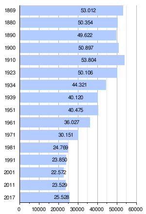
After the district was founded, Josefstadt had a population of 53,012 in 1869. Due to the already dense development of the district area, this value hardly changed until 1910. After that, the population began to decline almost continuously, with the number falling the most in the 1960s and 1970s. The main reason for the decline was the increased need for living space. With 22,572 inhabitants, the population reached its lowest level in 2001. Since then it has increased slightly again and at the beginning of 2015 was 24,463 people.
Population structure
The age structure of the Josefstadt population in 2011 deviated from the Viennese average, especially for children and young adults. While 10.4% of the population in Josefstadt were under 15 years of age in 2011, the figure in Vienna was significantly higher at 14.4%. In contrast, the proportion of the population between the ages of 20 and 29 was 19.6%, above the Vienna average of 12.8%, primarily due to the high number of students. The proportion of the population over 65 years of age was 15.4%, below the Vienna figure of 17.8%. The gender distribution in the district was with a share of 48.3% men and 51.7% women in the range of the Viennese average, while the Josefstadters were married less often than the average Viennese with 32.4% compared to 41.2%. The unemployment rate in 2011 was 5.6%, well below the Vienna average of 9.6%.
level of education
In 2011, 49.0% of those over 15 had a secondary qualification (AHS, BMS or apprenticeship) and 35.9% a tertiary qualification (university, academy or college qualification) as the highest degree, which is well above the Vienna average of 11.6%.
origin
The proportion of foreign residents in the district was 28.7% in 2016 (Vienna: 27.4%) and, as in all of Vienna, shows a strong upward trend (2001: 16.1%). The highest proportion of foreigners in 2016 was made up of around 5.7% of the district population, citizens from Germany . Another 2.5% were Serbian , 1.3% Hungarian and 1.2% each Polish and Romanian citizens. The rest is due to other foreign nationals.
religion
The proportions of religious denominations in the population of Josefstadt are essentially in line with Vienna's average, with the proportion of Catholic and Protestant being slightly above, and the proportion of the Islamic population being more below average. In the 2001 census, 52.0% of residents said they belong to the Roman Catholic Church . There are three Roman Catholic parishes in the municipality that belong to the city dean's office 8/9 . 6.0% of the population were Protestant , 4.6% of the Islamic faith, 5.2% belonged to the Orthodox Church . 23.8% of the district population was without a religion. 7.8% had given no or a different religion.
politics
| District chairman since 1945 | |
|---|---|
| Egon Schiska ( KPÖ ) | 4 / 1945–7 / 1945 |
| Gustav Lorant ( ÖVP ) | 7 / 1945–11 / 1945 |
| Richard Honetz (ÖVP) | 1945-1946 |
| Hans Preyer (ÖVP) | 1946-1950 |
| Alexander Riedl (ÖVP) | 1950-1954 |
| Franz Bartl (ÖVP) | 1954-1959 |
| Marie Franc (ÖVP) | 1959-1964 |
| Walter Kasparek (ÖVP) | 1964-1990 |
| Ludwig Zerzan (ÖVP) | 1990-1994 |
| Franz Neubauer (ÖVP) | 1994-1998 |
| Margit Kostal (ÖVP) | 1998-2005 |
| Heribert Rahdjian (REAL, previously Green) | 2005-2010 |
| Veronika Mickel (ÖVP) | 2010 – ongoing |
The Josefstadt district is traditionally a bourgeois district. After the Second World War, the ÖVP was the party with the strongest votes between 1945 and 2005 and consisted of the district chairman. Again and again the ÖVP achieved an absolute majority in Josefstadt. Due to the electoral successes of the Greens in the late 1980s and the appearance of the Liberal Forum in 1996, the ÖVP, but also the SPÖ, increasingly lost votes. The FPÖ never played an important role in Josefstadt. To this end, a citizens' list (Bürgerforum Josefstadt) was established in Josefstadt, which between 1991 and 2001 reached between 7.0% and 8.3%. In the 2001 elections, the Greens made strong profits. The ÖVP was only just able to keep the SPÖ and the Greens behind. In order to secure the endangered position as the front runner, the civil citizens' forum Josefstadt and the ÖVP joined forces to form the PRO Josefstadt list. Nevertheless, the Greens emerged victorious from the elections in 2005 with a gain of 7.7%. The PRO Josefstadt list remained around 3.7% behind the result that the Citizens' Forum and the ÖVP had achieved together in 2001. The SPÖ also made profits, while the FPÖ lost heavily and the Liberal Forum was finally thrown out of the district council. From 2005 until the next district representative election in 2010 , the Greens appointed Heribert Rahdjian as the district chairman, which meant that the Greens had two district leaders in Vienna with Josefstadt and the neighboring new building. In the summer of 2010, Heribert Rahdjian decided to run a new list “REAL Green - List Heribert Rahdjian” for the district representative election on October 10, 2010. In the district council, a separate club Echt Grün was established with three mandataries, consisting of the former Green Club chairwoman, another district councilor and the chairman of the district council. As a result of the election, his parliamentary group grew to five mandataries, making ECHT the strongest district party in Vienna. Veronika Mickel-Göttfert has been the incumbent district head
since November 2010 . Your deputies are currently Josef Mantel (ÖVP) and Alexander Spritzendorfer (Greens).
| year | SPÖ | ÖVP | FPÖ | Green | NEOS | LIF | PRO / BFJ | REALLY | Others |
|---|---|---|---|---|---|---|---|---|---|
| 1991 | 28.1 | 31.6 | 16.0 | 14.7 | nk | nk | 7.5 | nk | 2.1 |
| 1996 | 21.6 | 27.2 | 16.9 | 15.5 | nk | 9.8 | 8.3 | nk | 0.7 |
| 2001 | 24.7 | 25.2 | 13.3 | 24.5 | nk | 4.4 | 7.0 | nk | 0.8 |
| 2005 | 28.6 | nk | 6.8 | 32.3 | nk | 1.0 | 29.0 | nk | 2.3 |
| 2010 | 23.5 | 27.5 | 9.0 | 24.2 | nk | 1.3 | nk | 11.6 | 2.9 |
| 2015 | 19.7 | 30.6 | 10.0 | 27.2 | 6.0 | nk | nk | 4.3 | 2.3 |
coat of arms
The coat of arms of the Josefstadt district represents the five former, independent communities from which the 8th district was formed in 1850. The heart shield shows Saint Joseph standing in a meadow on a blue background. It symbolizes the district of Josefstadt , which was named in honor of Emperor Joseph . In one hand he holds a trunk of lilies and in the other the baby Jesus . In the upper right part of the coat of arms a magpie symbolizes the Alservorstadt district as a speaking coat of arms . She is sitting on a leafy shrub against a golden background . In the upper left part of the coat of arms the coat of arms of Altlerchenfeld is shown. The red ground is divided by a silver cross, in the four fields there are four golden larks. In the lower left part of the coat of arms, Saint Mary stands for the Breitenfeld district . She hovers on a cloud over a green meadow and wears a gold robe with a red cloak. In her hands she holds the scepter and orb . The depiction comes from the coat of arms of the Schottenstift , which had numerous possessions here. The lower right part of the coat of arms stands for the Strozzigrund . It shows the coat of arms of Count Strozzi with a silver crossbar on a red background. Countess Maria Katharina Strozzi , initiated the development of the area through her construction work.
Culture and sights
_-_Piaristenkirche.JPG)


- Theater in der Josefstadt , a traditional bourgeois stage
- Vienna's English Theater , oldest English-speaking theater in Europe outside the UK
- Baroque Piarist Church of Maria Treu with paintings by the painter Maulbertsch
- Breitenfeld parish church , brick shell in the style of the Lombard early Renaissance
- Austrian Museum of Folklore in the Schönborn Palace , Laudongasse 15–19
- Auersperg Palace
- House "Zur Heiligen Dreifaltigkeit" (today "Alte Backstube"), Lange Gasse 34 - a classic example of baroque suburban architecture.
- Palais Strozzi , Josefstädter Strasse 39.
- Lenaugasse , the entire alley, is an example of pre-March architecture and is under ensemble protection.
- District Museum Josefstadt , Schmidgasse 18
- Le Petit - The smallest theater in the world (19 seats), Schlösselgasse 21
- Theatro Kosilo - the smallest stage in Vienna (5 m²), Neudeggergasse 14.
- Cabaret Niedermair , Lenaugasse 1a, a cabaret and cabaret stage or children's theater
- Pygmalion Theater Vienna , Alser Strasse 43
The eastern part of the municipality belongs to the outer zone of the World Heritage Site Historic Center of Vienna . This is bordered in the west by Langen Gasse, Laudongasse, Lederergasse, Josefstädter Strasse and Piaristengasse. The most famous coffee houses in Josefstadt are Café Hummel , Cafe Florianihof and Café Eiles .
Josefstadt in literature and on television
- Ödön von Horváth's play Tales from the Vienna Woods is partly set in Langen Gasse, a side street off Josefstädter Strasse. Lange Gasse 29, in which there is now a pub, served as the backdrop for the film.
- In 2007, ORF 1 ran the daily soap opera Mitten im 8en , which was not filmed in the 8th district, but mostly in the second.
- The Austrian television series Dolce Vita & Co , produced in 2001/2002, is set in part in Josefstadt.
- Arthur Schnitzler's dream novel is also set in part in Josefstadt, including the Wickenburggase and Buchfeldgasse.
Museums
The Austrian Museum of Folklore in the Schönborn Palace is the largest folklore museum in Austria. The museum was founded in 1895 and covers all areas of the former monarchy. The Kaiser Franz Joseph hat museum and the KuK wine treasure chamber are located in the Piarist cellar . Said hat museum focuses its collection on hats from the time of Emperor Franz Joseph I , while the wine treasury has rarities from the crown lands from three centuries, with a focus on dessert wines, especially Madeira wines from 1795 to 1916 as well as rare Tokaj wines . The District Museum Josefstadt is dedicated to the district history of Josefstadt.
Parks
With a park area of 2.09 hectares, Josefstadt has the smallest park areas in any district of Vienna. The largest park (around 10,000 m²) in Josefstadt is Schönbornpark in the area of Florianigasse and Langer Gasse. The park goes back to a garden palace with gardens from the 18th century, which Imperial Vice Chancellor Friedrich Carl von Schönborn had built. In 1862 the property was greatly reduced and opened as Schönbornpark. At around 6,000 m², the Hamerlingpark at Hamerlingplatz is about half the size and was built on the site of the Josefstadt barracks that were demolished in 1910 . The Tigerpark at the intersection of Tigergasse and Pfeilgasse is the smallest park in Josefstadt (1,600 m²). The Tigerpark is actually a roof garden opened in 1995 on an underground car park that was built on the site of a former factory.
Economy and Infrastructure
_DSC00283.jpg)
traffic
The underground station Josefstädter Straße on the U6 line is on the border with Ottakring and the Rathaus underground station on the U2 line on the border with the Inner City . There are several tram and bus routes in the district.
Dormitories
There are a considerable number of student residences in Josefstadt , for example the VINDOBONA house of the Adolf Schärf Board of Trustees on the corner of Skoda- and Laudongasse, the homes operated by Akademikerhilfe in Pfeilgasse (Pfeilgasse 1a, 3a and 4–6), the student residence Hotel Korotan (Albertgasse 48), the Neudeggergasse dormitory run by Student Aid (Neudeggergasse 21) and the Friedrich-Funder dormitory in Strozzigasse.
Education and health
In Josefstadt there are four public elementary schools, a cooperative middle school , three grammar schools (in Feldgasse , Albertgasse and on Jodok-Fink-Platz ) and the Federal Training Institute for Kindergarten Education in Albertgasse. The Vienna Business School , the commercial academy and the commercial school of the Viennese business community are located on Hamerlingplatz . Another Vienna Business School is located on Schönborngasse. In March 2018, a second location of the LIMAK Austrian Business School was opened in Strozzigasse in addition to Linz .
The headquarters of the music schools are now in Laudongasse, in the former main library . Since the opening of the new main library on Urban-Loritz-Platz (near the eighth district), the eighth and first districts are the only districts in Vienna without their own library branch. The Josefstadt Adult Education Center is located in Schmidgasse . An important leisure-time educational facility is Austria's largest game library , the WienXtra-Spielebox at Albertgasse 35. The Institute for Leisure Education is also located in the same building .
The Confraternität Privatklinik Josefstadt has been located at Skodagasse 32 since 1835 .
safety
Two police stations of the Federal Police are established in Josefstadt , these are located at Fuhrmannsgasse 5 and at Hernalser Gürtel 6-12 (actually Laudongasse 64, it is an identification address). In the Fuhrmannsgasse department there is the Josefstadt City Police Command, which is responsible for the districts of Neubau and Alsergrund as well as for Josefstadt.
Personalities
- HC Artmann (1921–2000), writer and poet
- Milo Dor (1923-2005), writer
- Marie von Ebner-Eschenbach (1830–1916), writer
- Heinz Fischer (* 1938), former Federal President D.
- Karl von Frisch (1886–1982), researcher and Nobel Prize winner
- Kurt Gödel (1906–1978), mathematician and logician
- Ödön von Horváth (1901–1938), writer
- Fritz Löhner-Beda (1883–1942), writer
- Johann Lukas von Hildebrandt (1668–1745), master builder
- Theodor Oppolzer (1841–1886), astronomer
- Andreas P. Pittler (* 1964), writer
- Anna-Lülja Praun (1906–2004), architect and designer
- Adolf Schärf (1890–1965), Federal President
- Ernst Streeruwitz (1874–1952), Federal Chancellor
- Karl Wilhelm von Scheibler (1772–1843), fortress commander
- Anton Wildgans (1881–1932), poet and playwright
- Oskar Werner (1922–1984), film and stage actor
Town twinning
-

 Josefstadt and the districts of the same name in Budapest (Józsefváros) and Timișoara (Iosefin) together form the Federation of Josefstadt with the aim of improving cultural exchange.
See also
literature
- Felix Czeike: Viennese district culture guide: VIII. Josefstadt . Jugend und Volk, Vienna 1980, ISBN 3-7141-6226-7 .
- Elfriede Faber: Time leaps Vienna-Josefstadt. Sutton Verlag, Erfurt 2006, ISBN 978-3-89702-875-3 .
- Christine Klusacek: Josefstadt. Bars, stages, officials. Mohl, Vienna 1991, ISBN 3-900272-40-9 .
- Carola Leitner: Josefstadt: Vienna's 8th district in old photographs . Ueberreuter, Vienna 2006, ISBN 3-8000-7204-1 .
- Theresa Aigner, Claudia Kahla: Women in Josefstadt. Your life. Your work. Your work. Josefstadt district administration, Vienna 2012, ( full text online PDF, free of charge, 44 pages, 4.7 MB, with: Marie von Ebner-Eschenbach , Rosa Mayreder , Eugenie Schwarzwald , Therese Schlesinger , Maria Franc , Anna-Lülja Praun , Alma Johanna Koenig , Lisette Model ).
Web links
- Josefstadt on the website of wien.gv.at
- Josefstadt: The district in which one is at home , A portrait of the Josefstadt by Friederike Leibl in Die Presse
- District information Vienna 8 - Josefstadt
- District Museum Josefstadt
- The Josefstadt - News from and around Vienna 8
Individual evidence
- ↑ Statistics Austria - Population at the beginning of 2002–2020 by municipalities (area status 01/01/2020)
- ↑ District council elections 2015
- ↑ tuner; Klusacek: Josefstadt p. 3.
- ↑ a b Municipal Department 5 (MA5): Types of use by district PDF ( Memento from September 29, 2007 in the Internet Archive )
- ↑ Law on changing the border between the 1st and 8th district (LGBl. For Vienna 13/1995), issued on March 20, 1995.
- ↑ District history of Josefstadt , on wien.gv.at, accessed on April 12, 2015.
- ↑ Interactive map of Vienna - cultural property , on wien.gv.at, accessed on April 11, 2015.
- ↑ Register census 2011: Community table Vienna , Statistics.at (PDF, 18 kB).
- ↑ a b Census from May 15, 2001. Vienna district: Vienna 9., Alsergrund , Statistics Austria (PDF; 10 kB) Vienna (PDF; 11 kB)
- ↑ Population by nationality ( memento of the original from October 6, 2014 in the Internet Archive ) Info: The archive link was inserted automatically and has not yet been checked. Please check the original and archive link according to the instructions and then remove this notice. , Statistics Austria. Retrieved June 18, 2016.
- ↑ Klusacek; Tuner: Josefstadt p. 105 ff.
- ^ City of Vienna - Viennese municipal and district council elections
- ↑ Vienna City Garden Authority (MA 42)
- ↑ orf.at: Linz Business School also teaches in Vienna . Article dated May 30, 2018, accessed June 22, 2018.
- ^ Adolf Schärf in the Vienna History Wiki of the City of Vienna
- ^ Oskar Werner in the Vienna History Wiki of the City of Vienna
- ^ Revolution in the Josefstadt. In: The Standard. March 30, 2009. Retrieved July 9, 2017 .
1., Inner City | 2., Leopoldstadt | 3rd, highway | 4., Wieden | 5th, Margareten | 6., Mariahilf | 7., new building | 8., Josefstadt | 9., Alsergrund | 10., Favorites | 11., Simmering | 12., Meidling | 13., Hietzing | 14., Penzing | 15., Rudolfsheim-Fünfhaus | 16., Ottakring | 17th, Hernals | 18., Währing | 19., Döbling | 20th, Brigittenau | 21., Floridsdorf | 22., Donaustadt | 23rd, Liesing