
Florianigasse
| Florianigasse | |
|---|---|
|
|
|
 |
|
| Florianigasse at Buchfeldgasse | |
| Basic data | |
| place | Vienna-Josefstadt |
| District | Josefstadt |
| Hist. Names | Schottentorgasse, Kaserngasse, Magazingasse |
| Cross streets | Wickenburggasse, Schlösselgasse, Buchfeldgasse, Lammgasse, Lange Gasse, Piaristengasse, Kochgasse, Lederergasse, Fuhrmannsgasse, Schönborngasse, Skodagasse, Feldgasse, Albertgasse, Bennogasse, Blindengasse |
| Places | Schlesingerplatz, Bennoplatz, Uhlplatz |
| use | |
| User groups | Pedestrian traffic , bicycle traffic , car traffic , underground lines U2, U6, tram lines 2, 5, 33 |
| Technical specifications | |
| Street length | approx. 1.2 km |
The Florianigasse is located in the 8th Viennese district of Josefstadt . It was named at number 15 after the house sign “Zum Heiligen Florian”.
history
Florianigasse is one of the oldest streets in the former suburb of Josefstadt . In the early 18th century the region was built with a garden palace of the nobility, of which the Schönborn and Damian palaces are still preserved today. In 1772 the construction of the Josefstädter Reiterkaserne began, which was located between Florianigasse, Josefstädter Straße, Albertgasse and Schönborngasse. Schönbornpark was opened in 1862 and is still the largest park in the district. In 1898 the Breitenfeld parish church was opened at the western end of Florianigasse . In 1912 the office building of the district administration on Schlesingerplatz went into operation. The part of the street close to the center has been part of the outer zone of the world cultural heritage (historical center of Vienna) since 2001 .
Location and characteristics
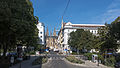
Florianigasse begins opposite the Vienna City Hall in Florianipark on Landesgerichtsstrasse . From here the road leads west past Schönbornpark and Schlesingerplatz over Bennoplatz, and finally ends at Uhlplatz in front of the Breitenfeld parish church. In its course, the alley expands again and again into squares and parks and thus also forms an important local recreation area in the densely built-up district. The development was largely spared from war damage and is today characterized by a large variety of some very beautiful apartment buildings from the 18th, 19th and early 20th centuries. The western part of the alley is dominated by the line of sight to the Breitenfeld parish church on Uhlplatz.
gallery

The beginning of Florianigasse at Landesgerichtsstrasse

At Schlösselgasse

At Langen Gasse, Schönbornpark on the right

At Kochgasse

At Fuhrmannsgasse

At Skodagasse
At Bennoplatz

The end of the alley at Blindengasse


Web links
Coordinates: 48 ° 12 '42 " N , 16 ° 21' 4" E