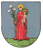
Josefstadt (district of Vienna)
| Josefstadt | |
|---|---|
| coat of arms | map |
 |

|
The Josefstadt was a suburb of Vienna and since its incorporation 1850/61 the eponymous district part of the 8th district of Vienna Josefstadt .
geography
Within the municipality, the district part essentially takes up the area between Florianigasse in the north and Josefstädter Straße in the south. In the southeast, the streets of Langen Gasse south of Josefstädter Strasse as well as Josefsgasse and Trautsongasse also belong to the Josefstadt district.
In the west the former suburb borders on the district of Ottakring on the other side of the Viennese belt , in the east on the district of Innere Stadt on the other side of the two-line line and in the southeast on the district of Neubau . The district part of Josefstadt shares borders with the four other district parts: in the north with the Alservorstadt and Breitenfeld , in the south with Altlerchenfeld and the Strozzigrund .
With the exception of Hamerlingpark, there are no large green spaces in Josefstadt; the former suburb is now a densely built-up residential area.
history
The area between Ottakringerbach and Alserbach had been owned by the Schottenstift since the 12th century . After the second Turkish siege of Vienna in 1683, building work began on the grounds, with the Rote Hof, first mentioned in 1491, forming the historical core of what would later become the suburb. This manor was acquired by Marchese Hippolyto Malaspina in 1690 and the associated grounds were parceled out. By 1700 there were already 60 houses here. This year Malaspina sold the estate to the city of Vienna, which now after the later Emperor Joseph I was named.
In 1772 the construction of the Josefstädter Kaserne began, in its place after 1910 the district around the Hamerlingplatz was laid out. Already in 1850 the incorporation of the suburbs of Vienna was decided, which was implemented in 1861. Since then, Josefstadt has been the eponymous part of Vienna's 8th district.
Culture and sights
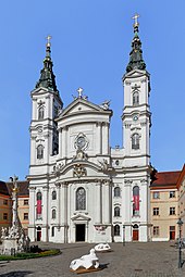
The Piarist Church of Maria Treu is a Baroque Roman Catholic parish church in the center of the district. The most important church building in Josefstadt is a minor basilica .
In the extreme southeast of the district is the baroque Palais Auersperg , which was built from 1706 to 1710 according to the plans of the architects Johann Bernhard Fischer von Erlach and Johann Lucas von Hildebrandt . Another baroque palace is the Palais Damian , built around 1700 in Langen Gasse.
The theater in der Josefstadt , opened in 1788, is the oldest theater in Vienna that is still in use. Vienna's English Theater is located on Josefsgasse . The anti-Semitic court, which was named after the anti-Semitic newspapers that were based here, is also located here.
Economy and Infrastructure
The Vienna 8th Federal High School is located at the Maria Treu Piarist Church . The Café Hummel is a traditional coffee house on Josefstädter Straße. The headquarters of the arms dealer Joh. Springer's Erben is located in Josefsgasse .
The Rathaus subway station is located on the eastern border of Josefstadt and the Josefstädter Straße subway station on the western border , in which the Café Carina is a well-known artist and music café.
Personalities
- Johann Ferdinand Hetzendorf von Hohenberg (1732–1816), early classicist architect
literature
- Christine Klusacek, Kurt Stimmer: Josefstadt. Bars, stages, officials . Vienna 1991, ISBN 3-900272-40-9
- Hans Rotter: The Josefstadt. History of the 8th district of Vienna . Vienna 1918
Individual evidence
- ^ Dehio-Handbuch Wien. II. To IX. and XX. District . Edited by Federal Monuments Office. Anton Schroll, Vienna 1993, ISBN 3-7031-0680-8 , p. 323
Web links
Coordinates: 48 ° 12 ′ 37.8 ″ N , 16 ° 21 ′ 0.5 ″ E

