
Wattgasse
| Wattgasse | |
|---|---|
|
|
|
 |
|
| Wattgasse at Ottakringer Straße | |
| Basic data | |
| place | Vienna |
| District | Ottakring , Hernals |
| Hist. Names | Sterngasse, Bahngasse |
| Name received | 1884 |
| Connecting roads | Possingergasse and Schuhmeierplatz (south), Lidlgasse (north) |
| Cross streets | Friedrich-Kaiser-Gasse, Ottakringer Strasse , Arnethgasse, Degengasse, Mayssengasse, Wilhelminenstrasse, Geblergasse - Seeböckgasse, Lobenhauergasse - Effingergasse, Mariengasse - Albrechtskreithgasse, Paletzgasse, Sautergasse, Hernalser Hauptstrasse , Rötzergasse, Rhgendorfgasse -, Roggendhausengasse |
| Places | Family place |
| use | |
| User groups | Pedestrians , cyclists , motor vehicles , bus route 10A |
| Technical specifications | |
| Street length | approx. 1,435 m |
The Wattgasse in Vienna is running in a north-south direction important transportation link in the 16th district, Ottakring , and in the 17th, Hernals . In terms of road law, it has the rank of main street A.
Surname
The street was called Sterngasse in Ottakring until 1884 and Bahngasse until 1894 in Hernals . In today's 16th district it was named by the Ottakring municipal council Wattgasse before the two local parishes were incorporated into Vienna in 1892, and in today's 17th district after the incorporation by the Vienna city administration.
It was named after the Scottish inventor James Watt (1736–1819) at a time when electricity was increasingly establishing itself as an important energy source; In 1883 the International Electrical Exhibition took place in the Vienna Rotunda .
location
Wattgasse is part of a north-south connecting route between the western outskirts of Vienna, which leads from Gersthof to directly in front of Schönbrunn Palace ; On this connection, seen from the north, it forms the 13-block section from the southern end of Lidlgasse (crossing Richthausenstraße / Roggendorfgasse) to Thaliastraße (northern end of Possingergasse). It runs parallel to the belt about twelve to 15 blocks away.
For districts 16 and 17, it is an important cross-connection that crosses the main shopping streets of these districts ( Hernalser Hauptstraße , Ottakringer Straße , Thaliastraße).
In accordance with the house numbering rules for streets that (partially) circle the center of Vienna, the houses on Wattgasse are numbered clockwise, starting with numbers 1 and 2 on Thaliastraße. The buildings on the western side of Wattgasse have odd house numbers, and even numbers are on the eastern side of the street (closer to the city center).
The Wattgasse forms the district border in the section from 16. / Seeböckgasse / 17., Geblergasse, to 16. / 17., Sautergasse (16th district on the western side of the street). Odd house numbers up to No. 65 and even house numbers up to No. 46 belong to the 16th district.
traffic
The lane is to the full length of the urban bus lines 10A ( subway station Heiligenstadt to Niederhofstraße operated). Tram lines 43, 44, 2 (formerly J and 45) and 46 run into the city center on intersecting streets .
Because of the heavy traffic, the quality of stay along Wattgasse is poor.
Buildings
The most famous buildings in the Wattgasse area include the Neuottakringer Church (1894–1898) on Familienplatz (until 1992 Kernstockplatz) in the 16th district, which interrupts Wattgasse between house numbers 15 and 17 or 22 and 24, and the Redemptorist Church ( 1886–1889) in the 17th district, which is one block from Wattgasse 62 through Mariengasse towards the city center, on Clemens-Hofbauer-Platz.
In addition, a number of buildings remind of the past of the quarter as an industrial area interspersed with late-founding workers' houses.
The municipal housing built in 1965–1967 at nos. 9 and 11 was named after the social democratic trade unionist and politician Wilhelmine Moik (1894–1970) after her death (memorial plaque). Most of the residential buildings along Wattgasse date from the last quarter of the 19th century and - with a few exceptions (such as the twin house at No. 20, built in 1912 according to plans by the well-known architect Richard Modern) - have a suburban character. The sober rental house at Wattgasse 62 and the post and telephone office (No. 56-60), which today houses the Federal Art and Photography Funding Studios , date from the time of Austro-Fascism .
The section of the alley north of Hernalser Hauptstrasse was not yet available on a city map from around 1910. The tram depot ( Hernals depot ) at the corner of Wattgasse / Hernalser Hauptstraße was built between 1900 and 1913. The area is also characterized by servant houses and large residential complexes from the late 1920s.

Basic machine hall (built around 1900) of the former Ottakringer iron foundry u. Machine factory Fernau (Wattgasse 30–32)

Vicarage of the Neuottakringer Church on Familienplatz, 1894–1898
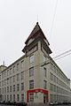
Former office products factory KORES (Wattgasse 48), 1915–1919 / 1929

Hernals depot, 1900–1913

Residential complex Wattgasse 88, 1928/1929

Redemptorist Church on Clemens-Hofbauer-Platz, 1886–1889


gallery

The beginning of the street at Thaliastraße

At Degengasse

At Lobenhauerngasse

At the Hernalser Hauptstrasse, on the left is the Hernals depot

The end of the street at Roggendorfgasse


Web links
Individual evidence
- ^ Felix Czeike : Historisches Lexikon Wien , Volume 5, Kremayr & Scheriau, Vienna 1997, ISBN 3-218-00547-7 , p. 592
- ^ Felix Czeike: Wiener Bezirkskulturführer XVI · Ottakring , Jugend und Volk, Vienna 1981, ISBN 3-7141-6233-X , p. 62
- ^ Website of the artists of the studios
- ^ The studios on a website of the Ministry of Education ( Memento from May 12, 2014 in the Internet Archive )
- ^ Mention of the Remise in a list of Hernals sights on the website of the Vienna City Administration
- ^ The municipal building Wattgasse 96-98 on a website of the municipal housing management