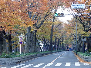
Fuchu (Tokyo)
| Fuchu-shi 府中 市 |
||
|---|---|---|
| Geographical location in Japan | ||
|
|
||
| Region : | Kanto | |
| Prefecture : | Tokyo | |
| Coordinates : | 35 ° 40 ′ N , 139 ° 29 ′ E | |
| Basic data | ||
| Surface: | 29.34 km² | |
| Residents : | 263,932 (October 1, 2019) |
|
| Population density : | 8996 inhabitants per km² | |
| Community key : | 13206-3 | |
| Symbols | ||
| Flag / coat of arms: | ||
| Tree : | Japanese zelkove | |
| Flower : | Ume | |
| Bird : | Skylark | |
| town hall | ||
| Address : |
Fuchū City Hall 2 - 24 Miyanishi-chō Fuchū -shi Tōkyō 183-8703 |
|
| Website URL: | http://www.city.fuchu.tokyo.jp | |
| Location of Fuchūs in Tokyo Prefecture | ||
Fuchū ( Japanese 府中 市 , - shi ) is a city in Tokyo Prefecture .
geography
Fuchū is west of Tokyo and Chōfu , and east of Hachioji . The Tama River flows through the city from southwest to southeast.
history
The city was founded on April 1, 1954. It is best known for the Tama cemetery , the largest in the prefecture, where many famous people are buried. The place is also known for the Tokyo racecourse , the largest in the country.
traffic
- Train:
- Keiō Line : to Shinjuku (20 min)
- JR Musashino Line : to Saitama and Funabashi
- JR Nambu Line : to Kawasaki and Tachikawa
- Street:
- Chūō Highway
- National road 20 : to Tōkyō or Shiojiri
Neighboring cities and communities
sons and daughters of the town
- Ryūjoseph Hashimura (* 2000), football player
- Jun Ichikawa (1948–2008), film director and screenwriter
- Tetsuya Komuro (* 1958), keyboard player, songwriter and music producer
- Jumma Miyazaki (* 2000), soccer player
- Homare Sawa (* 1978), soccer player
- Ryūji Sugimoto (* 1993), football player
- Naoki Urasawa (* 1960), Mangaka
- Teppei Usui (* 1991), football player
Town twinning
- 1974 Sakuho (originally the incorporated Yachiho ; sister city)

- 1992 Hernals , Vienna (city friendship)

Individual evidence
- ↑ City of Fuchu: Introduction of Sister City ( Memento from July 21, 2009 in the Internet Archive ) (English)
- ↑ City of Fuchu: Friendship City Introduction ( Memento from September 30, 2012 in the Internet Archive ) (English)
Web links
Commons : Fuchū - collection of images, videos and audio files


