
Kanto
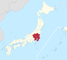


Kantō ( Japanese 関 東 地方 , -chihō ) is a region of Japan on the largest island of Honshū . The name comes from the fact that the region to the east ( 東 , tō ) of the border station ( 関 所 , sekisho , the on-reading of the first character is kan ) is Hakone ; it is derived from the old customs barrier and literally means "east of the barrier".
The north of Kantō with the prefectures Gunma , Tochigi and Ibaraki is similarly rural as the Tōhoku region . The prefectures Tokyo , Saitama , Kanagawa and Chiba , on the other hand, are mainly shaped by the metropolitan area of Tokyo .
Geographically, the region consists mainly of the Kantō Plain ( 関 東 平野 , Kantō-heiya ) - the largest plain in Japan -, in the north and west of the Kantō Mountains ( 関 東山 地 , Kantō-sanchi ), in the northeast of the foothills of the Abukuma Mountainous country ( 阿 武 隈 山地 , Abukuma-sanchi ) and in the southeast from the Bōsō Peninsula .
On September 1, 1923, the Great Kanto earthquake with a magnitude of 7.9 destroyed the city of Yokohama and parts of neighboring Tokyo. Over 140,000 people died and more than 1.9 million were left homeless.
Attractions
The most important travel destination in Kantō is without a doubt the Japanese capital Tokyo . Together with Japan's second largest city, Yokohama and Kawasaki , the city of millions forms the largest metropolitan area in the world with over 36 million inhabitants. In addition to the vibrant metropolises, evidence of Japanese culture and history such as the old seat of government Kamakura in the southwest and the tombs of Tokugawa Ieyasu in Nikkō ( UNESCO World Heritage ) in the north beckon. The mountainous Tama region in the west offers wonderful landscapes, while the Pacific beaches beckon in the west of Chiba.
Prefectures
The region consists of seven prefectures , which together cover 32,423.90 km² (roughly the size of North Rhine-Westphalia ) and have 42.4 million inhabitants with an average population density of 1309 inhabitants / km² (as of June 1, 2010):
Together with the Kōshin'etsu region ( Nagano , Niigata and Yamanashi prefectures ), Kantō forms the Greater Kantō region ( 広 域 関 東 圏 , kōiki-kantō-ken ).
Web links
Individual evidence
- ↑ News from Japan No. 162 | May 2018, The Kanto region in the east of the main island of Honshu
- ↑ Essay ★ 10 相 模 川 の 段 丘 : 関 東 平野 の 西 に 住 ん で Letter ★ そ の 後 の 転 居 . In: 大地 を 眺 め る . 2005, accessed February 15, 2013 (Japanese).

Northern Japan : Hokkaidō ( east , north , center , south , "Northern Territories" (Southern Kuril Islands) ) | Tōhoku ( north , south )
Eastern Japan (in the narrower sense): Kantō ( north , south , Tokyo , Kantō-Kōshin'etsu ) | Chūbu ( Kōshin'etsu , Kantō-Kōshin'etsu , Shin'etsu , Kantō-Kōshin )
Central Japan : Chūbu ( Hokuriku , Tōkai , central highlands , San'ennanshin , Nōbi )
Western Japan (in the narrower sense): Kinki ( North , Keihanshin , Nanki ) | Chūgoku ( San'in , San'yō , Setouchi , Chūgoku-Shikoku ) | Shikoku ( Setouchi , North , South , Chūgoku-Shikoku )
South Japan : Kyushu ( north , south , central , west , east ) | southwestern islands ( Satsunan Islands , Okinawa , Sakishima , Daitō )
Coordinates: 36 ° 10 ′ 0 ″ N , 139 ° 47 ′ 0 ″ E