Kinki

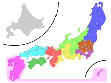
Kinki ( Japanese 近畿 , roughly "near the capital") is a region in Japan . Another term that is often interchangeable today is Kansai ( 関 西 , roughly "west of the border"). It is located in the western part of Honshūs , the main island of Japan, and forms the cultural, demographic, economic and political center of western Japan , and in earlier epochs also the whole of Japan.
The name Kinki comes from the fact that most of the Japanese imperial cities , most recently Kyoto , were in this region until the Meiji Restoration . The name Kansai originally referred to the region west of a certain border line, which shifted several times over the ages, similar to Kantō ("east of the border").
Definitions
Depending on the point of view and the discussion situation, Kinki includes the metropolitan area around the three cities of Osaka , Kobe and Kyōto , but mostly the entirety of the so-called city prefectures ( 府 , -fu ) Kyōto and Osaka and the prefectures ( 県 , -ken ) Nara , Wakayama , Hyōgo and Shiga , including Mie , Tokushima and Fukui . The Keihan region (Kyōto-Osaka) was also referred to as Kamigata ( 上方 ) during the Edo period , which translates as "higher place" and refers to Kyōto's function as the emperor's residence.
The exact definition varies. A distinction must be made between:
- the geographically / administratively defined region of Kinki ( 近畿 地方 , Kinki-chihō ), which comprises several prefectures as a whole, in some different definitions different prefectures, in traditional regional divisions but Osaka , Kyōto , Hyōgo , Nara , Mie , Shiga and Wakayama , with Mie in a number of contexts instead of Tōkai / Chūbu / Central / Eastern Japan , but sometimes Fukui , Tokushima and / or Tottori are included in Kinki / Kansai / Western Japan,
- a politically / administratively defined region is formed by the special purpose association Kansai , an amalgamation of several prefectural administrations,
- An equally political, very far- reaching definition can be found at the regional governors' conference Kinki block chijikai ( 近畿 ブ ロ ッ ク 知事 会 ), to which the governors of all the above-mentioned prefectures have belonged since 2008, analogously and explicitly also at the "Conference of the 10 Presidents of the Prefectural Parliament [resp. literally: presidents of parliaments of two -fu and eight -ken] of Kinki ”( 近畿 2 府 8 県 議会 議長 会 , Kinki 2 fu-, 8-kengikai-gichōkai ),
- the constituency / "block" Kinki for proportional representation in national lower house elections includes Osaka, Kyōto, Hyōgo, Nara, Shiga and Wakayama, the area of responsibility of several Kinki / Osaka field offices of ministries and authorities of the national government, the judicial district of the Osaka Higher Court , the broadcasting area Kinki of the public service broadcaster NHK , the Kinki region in weather reports from the State Meteorological Service and the Kinki Police Supervision Region of the National Police Department ,
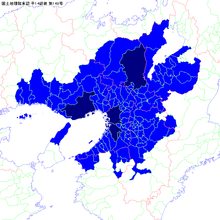
- the metropolitan region of Kinki ( 近畿 大都市 圏 , Kinki-daitoshiken ), defined according to population statistics , which includes areas with a high proportion of commuters around the central cities of Kyoto , Osaka , Kobe and, since it was named a city, also Sakai , and after the Sino-Japanese collective term for the original three major cities Often referred to as Keihanshin ( 京 阪神 ) (from 京 , the first kanji of 京都
Kyōto , 阪 , the second kanji of 大阪 Ōsaka , and 神 , the first kanji of 神 戸 Kobe ).
- The completely urbanized area around the three most important cities of Kyoto, Osaka and Kobe has a population of around 24.1 million, making it not only the second largest metropolitan complex in Japan, but also (according to the Fischer World Almanac ) the eleventh largest metropolitan region in the world .
Regional particularities
In contrast to the Kantō region, Kinki is polycentric : Kyoto as a cultural center, Osaka as a commercial center and culinary capital, Kobe as a modern and international city and many other cities of historical importance such as Nara .
The region, especially Osaka, is known and loved in Japan for its humor. The local, strongly pronounced Kansai dialect is a nationally notorious dialect and causes similar smiles in the north of the country as Bavarian may cause in northern Germany, although the Osaka variant of Kansai-ben in particular has more features of the Berlin snout .
The city pair Ōsaka ( 大阪 ) and Kobe ( 神 戸 ) are collectively referred to as Hanshin ( 阪神 ), formed from the second character of Ōsaka and the first of Kobe. This term denotes e.g. B. the highway between the two cities and is u. a. on behalf of the relevant railroad company and the Hanshin Tigers baseball team . Similarly, Keihan ( 京阪 ) refers to the cities of Kyōto ( 京都 ) and Osaka, Hanna ( 阪 奈 ) to Osaka and Nara ( 奈良 ) and Keihanshin ( 京 阪神 ) to the trio of the largest cities in the region.
Its metropolitan region covers 13,033 km² and has 19.3 million inhabitants (2015).
history

In the imperial Ritsuryō administration of the 7th century based on the Chinese model, Kinai ( 畿内 , roughly: interior of the capital ) consisted of five provinces and was the center of the Gokishichidō system:
Alternative names are Gokinai ( 五 畿内 , about "interior of the five capital areas") or Goki ( 五 畿 , "five capital areas").

Originally, Kantō referred to the eastern imperial districts ( -dō ) on the main roads of the same name ( -dō ) east of the border stations to the province of Ise (Tōkaidō), to the province of Ōmi or Mino (Tōsandō) and to the province of Echizen (Hokurikudō). In the Japanese Middle Ages , when Kamakura was the first seat of government in eastern Japan, the western border shifted from Kantō to the east, and Kansai came up as an opposite term. In the early modern / Edo period , the Hakone border station in Sagami Province (now Kanagawa Prefecture ) served as the western border of Kantō; Kansai remained as the opposite term but the region around Kyoto and Osaka.
Individual evidence
- ↑ 上方 . In: 世界 大 百科 事 典 第 2 版 at kotobank.jp. Retrieved December 13, 2013 (Japanese).
- ↑ Osaka Prefecture Administration : Kinki burokku chijikai (Japanese)
- ↑ Kishō-chō : 地 域名
- ↑ Keisatsu-chō : 管 区 警察局
- ↑ Sōmushō , tōkei-kyoku (Statistics Office): Map of the metropolitan regions ( daitoshiken & toshiken ) after the 2010 census
- ↑ Statistical Handbook of Japan 2015. 6. Population Density and Regional Distribution. Japanese Statistical Office, accessed July 15, 2016 .
Coordinates: 35 ° 1 ′ 0 ″ N , 135 ° 41 ′ 0 ″ E


