
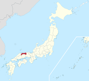
Tottori Prefecture
|
Tottori-ken 鳥取 県 |
|
|---|---|
  |
|
| Basic data | |
| Administrative headquarters : | Tottori |
| Region : | Chūgoku |
| Main island : | Honshu |
| Area : | 3,507.13 km² |
| Water content: | 0.7 % |
| Residents : | 555,663 (October 1, 2019) |
| Population density : | 158 inhabitants per km² |
| Counties : | 5 |
| Municipalities : | 19th |
| ISO 3166-2 : | JP-31 |
| Governor : | Shinji Hirai |
| Website: | www.pref.tottori.lg.jp |
| Symbols | |
| Prefecture flag : |
 |
| Prefecture tree : | Daisen -Kyaraboku ( Taxus cuspidata var. Nana ) |
| Prefecture flower : | Pyrus pyrifolia var. Culta ' Nijisseiki ' |
| Vogel prefecture : | Mandarin duck |
| Fish prefecture : | Paralichthys olivaceus |
| Prefecture song : |
Waki agaru chikara (" Emerging Force") |
| Citizens Day: | 12th September |
The Tottori Prefecture ( Jap. 鳥取県 , Tottori-ken ) is a prefecture of Japan , the smallest by population. It is located in the Chūgoku region on the main island of Honshū of Japan. The seat of the prefecture administration is the city of the same name Tottori .
history
The old imperial chronicles Kojiki and Nihonshoki from the early 8th century tell of episodes that are said to have occurred at the time of Emperor Suinin in the year 213. When Prince Homutsuwake spoke for the first time at the age of 30 after seeing a swan, Suinin promised to reward whoever caught the swan, whereupon Ame-no-yu-kawa-tana the title ( kabane ) of miyatsuko no totori 'head of the Vogelfang [= totori ] guild 'received.
The Japanese dictionary Wamyō Ruijushō from the year 938 for the district Aimi a village with the name Tottori in the area of today's city of the same name.
During the Edo period , the fiefdom ( han ) Tottori, which was ruled by the Ikeda , came into being in the provinces of Hōki and Inaba . With the abolition of the Han in 1871, the fiefdom became the first Tottori Prefecture, but in 1876 it was added to Shimane Prefecture . In 1881 it was spun off from this within its current boundaries.
politics
Governor Tottoris has been Shinji Hirai since 2007 and was confirmed for a fourth term in the unified regional elections in April 2019 . In the simultaneous parliamentary election, the Liberal Democratic Party (LDP) remained clearly the strongest party with 14 seats and continues to dominate parliament together with conservative independents.
In the national parliament , Tottori is represented by two directly elected members in the Chamber of Deputies , even after the 2017 election the Liberal Democrats Ryōsei Akazawa (constituency 2, 2017: 53%), grandson of Interior Minister Masamichi Akazawa , and Shigeru Ishiba (constituency 1, 2017: 84%) against only one, communist challenger), son of Interior Minister and Governor Jirō Ishiba . In the council house , Tottori and the neighboring Shimane have formed the unified Tottori-Shimane constituency since 2016 and, with the 2019 election, lost its independent representation in both halves of the chamber. However, the LDP has implemented a change in proportional representation for 2019, with which candidates can be excluded from voter preferences and placed on proportional representation lists. The LDP uses the system to continue to grant the party associations from rural prefectures affected by the introduction of the unified constituencies, with mostly secure LDP seats, a safe representation and thus parliamentary say in the award of infrastructure projects and grants from the central government. In 2019, Shōji Mataichi from Tottori received the (successful) LDP candidacy in the common constituency of Tottori-Shimane, while Yasushi Miura from Shimane was ranked second in the proportional representation.
Tottori is one of the financially weakest prefectures in the country.
Administrative division
The prefecture is divided into 4 independent cities ( Shi ), 14 small towns ( Chō ) and one village ( Son ), the latter organized in 5 districts ( Gun ). Tottori . Since April 2018, the seat of the prefecture administration has also been a "core city" ( chūkakushi ).
In the table below, the districts ( 郡 ) are shown in italics, below each (indented) the small towns ( 町 ) and the village ( 村 ) within them. A dependency between rural district and small town can also be seen in the first three digits of the code (1st column). At the beginning of the table are the 4 independent cities.
| code | Surname | Area (in km²) | population | Population density (inh / km²) |
||
|---|---|---|---|---|---|---|
| Rōmaji | Kanji | 01.10.2017 1 | 01.10.2018 3 | 01/10/2015 2 | ||
| 31201 | Tottori -shi | 鳥取 市 | 765.31 | 190.090 | 193.717 | 253.12 |
| 31202 | Yonago- shi | 米 子 市 | 132.42 | 148.262 | 149.313 | 1127.57 |
| 31203 | Kurayoshi- shi | 倉 吉 市 | 272.06 | 47,439 | 49,044 | 180.27 |
| 31204 | Sakaiminato- shi | 境 港市 | 29.10 | 33,144 | 34,174 | 1174.36 |
| 31300 | Iwami-gun | 岩 美 郡 | 122.32 | 11,108 | 11,485 | 93.89 |
| 31302 | Iwami-cho | 岩 美 町 | 122.32 | 11,108 | 11,485 | 93.89 |
| 31320 | Yazu-gun | 八 頭 郡 | 630.58 | 25,997 | 27,408 | 43.46 |
| 31325 | Wakasa-cho | 若 桜 町 | 199.18 | 3055 | 3269 | 16.41 |
| 31328 | Chizu-cho | 智 頭 町 | 224.70 | 6689 | 7154 | 31.84 |
| 31329 | Yazu-cho | 八 頭 町 | 206.71 | 16,253 | 16,985 | 82.17 |
| 31360 | Tōhaku-gun | 東 伯 郡 | 508.36 | 53,606 | 55.276 | 108.73 |
| 31364 | Misasa-cho | 三 朝 町 | 233.52 | 6,205 | 6,490 | 27.79 |
| 31370 | Yurihama-cho | 湯 梨 浜 町 | 77.94 | 16,238 | 16,550 | 212.34 |
| 31371 | Kotoura-cho | 琴 浦 町 | 139.97 | 16,757 | 17,416 | 124.43 |
| 31372 | Hokuei-cho | 北 栄 町 | 56.94 | 14,406 | 14,820 | 260.27 |
| 31380 | Saihaku-gun | 西伯 郡 | 447.51 | 40,771 | 41,977 | 93.8 |
| 31384 | For that -son | 日 吉 津 村 | 4.20 | 3573 | 3439 | 818.81 |
| 31386 | Daisen-cho | 大 山 町 | 189.83 | 15,846 | 16,470 | 86.76 |
| 31389 | Nambu-cho | 南部 町 | 114.03 | 10,615 | 10,950 | 96.03 |
| 31390 | Hōki-chō | 伯 耆 町 | 139.44 | 10,737 | 11,118 | 79.73 |
| 31400 | Hino-gun | 日 野 郡 | 599.46 | 10.100 | 11,047 | 18.43 |
| 31401 | Nichinan-cho | 日南 町 | 340.96 | 4316 | 4765 | 13.98 |
| 31402 | Hino-cho | 日 野 町 | 133.98 | 2994 | 3278 | 24.47 |
| 31403 | Kofu-cho | 江 府 町 | 124.52 | 2790 | 3004 | 24.12 |
| Shi-bu ( All shi , part of urban districts) | 市 部 | 1198.90 | 418.935 | 426.248 | 355.53 | |
| Gun-bu ( All gun , proportion of counties) | 郡 部 | 2308.24 | 141,582 | 147.193 | 63.77 | |
| 31000 | Tottori-ken (Tottori Prefecture) | 鳥取 県 | 3507.13 | 560.517 | 573,441 | 163.51 |
swell
1 Area data from 2017
2 Results of the 2015 census
3 Estimated population 2018
Biggest places
| Census year | Residents | |||
|---|---|---|---|---|
| 2015 | 2010 | 2005 | 2000 | |
| Tottori | 193.717 | 197,449 | 201.740 | 150,439 |
| Yonago | 149.313 | 148.271 | 149,584 | 138,756 |
| Kurayoshi | 49,044 | 50,720 | 52,592 | 49,711 |
| Sakaiminato | 34,174 | 35,259 | 36,459 | 36,843 |
There were no changes in the independent cities during the period mentioned.
Population development in the prefecture
| Census year |
Total population |
male population |
female population |
Gender ratio men to 1000 women |
Area in km 2 |
Population density per km 2 |
|---|---|---|---|---|---|---|
| 1920 | 454.675 | 222,802 | 231.873 | 960.9 | 3489.48 | 130.30 |
| 1925 | 472.230 | 230,580 | 241,650 | 954.2 | 3489.48 | 135.33 |
| 1930 | 489.266 | 239.084 | 250.182 | 955.6 | 3489.48 | 140.21 |
| 1935 | 490.461 | 239,301 | 251.160 | 952.8 | 3489.48 | 140.55 |
| 1940 | 484,390 | 233.964 | 250,426 | 934.3 | 3489.48 | 138.81 |
| 1945 | 563.220 | 255.525 | 307,695 | 830.4 | 3489.48 | 161.41 |
| 1950 | 600.177 | 289,787 | 310,390 | 933.6 | 3488.50 | 172.04 |
| 1955 | 614.259 | 297.015 | 317.244 | 936.2 | 3488.39 | 176.09 |
| 1960 | 599.135 | 286.716 | 312,419 | 917.7 | 3488.39 | 171.75 |
| 1965 | 579.853 | 275,572 | 304.281 | 905.6 | 3489.02 | 166.19 |
| 1970 | 568,777 | 269.497 | 299.280 | 900.5 | 3491.70 | 162.89 |
| 1975 | 581.311 | 277.151 | 304.160 | 911.2 | 3491.78 | 166.48 |
| 1980 | 604.221 | 289,946 | 314.275 | 922.6 | 3492.34 | 173.01 |
| 1985 | 616.024 | 295,511 | 320,513 | 922.0 | 3492.70 | 176.37 |
| 1990 | 615.722 | 294,899 | 320,823 | 919.2 | 3497.79 | 176.03 |
| 1995 | 614.929 | 294,414 | 320,515 | 918.6 | 3507.01 | 175.34 |
| 2000 | 613.289 | 293,403 | 319,886 | 917.2 | 3507.17 | 174.87 |
| 2005 | 607.012 | 290.190 | 316.822 | 915.9 | 3507.25 | 173.07 |
| 2010 | 588,667 | 280.701 | 307.966 | 911.5 | 3507.28 | 167.84 |
| 2015 | 573,441 | 273,705 | 299.736 | 913.2 | 3507.05 | 163.51 |

Outline

Tottori Kannon-in
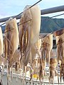
dried squid
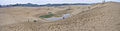
Sand dunes


literature
- Ronald J. DiCenzo: Daimyo, domain and retainer band in the seventeenth century: a study of institutional development in Echizen, Tottori and Matsue. Princeton, NJ, Princeton Univ., PhD thesis. Published by University Microfilms International, Ann Arbor, Michigan 1978.
Web links
Individual evidence
- ↑ http://had0.big.ous.ac.jp/plantsdic/gymnospermae/taxaceae/kyaraboku/daisenkyaraboku.htm
- ↑ Tottori Prefectural Parliament : MPs by parliamentary group , accessed on August 9, 2019.
- ↑ 統一 地方 選 2019 鳥取 県 議 選 各 党 議席 . In: NHK Senkyo Web. April 8, 2019. Retrieved August 9, 2019 (Japanese).
- ↑ Kokudo Chiriin (GSI - Geospatial Information Authority of Japan), 平 成 29 年 全国 都 道 府 県 市区 町 村 別 面積 調 (Nationwide survey of all prefectures and municipalities 2017) , p. 75: 31 Tottori-ken (Japanese), accessed on 1 January 2019
- ↑ e-stat (English), accessed on January 1, 2019
- ↑ 簡 単 検 索 ・ 詳細 検 索 ・ 検 索 サ ン プ ル , accessed January 1, 2019 (Japanese)
- ↑ e-Stat database , accessed on January 1, 2019 (English)
Aichi | Akita | Aomori | Chiba | Ehime | Fukui | Fukuoka | Fukushima | Gifu | Gunma | Hiroshima | Hokkaidō | Hyōgo | Ibaraki | Ishikawa | Iwate | Kagawa | Kagoshima | Kanagawa | Kochi | Kumamoto | Kyoto | Mie | Miyagi | Miyazaki | Nagano | Nagasaki | Nara | Niigata | Ōita | Okayama | Okinawa | Osaka | Saga | Saitama | Shiga | Shimane | Shizuoka | Tochigi | Tokyo | Tokushima | Tottori | Toyama | Wakayama | Yamagata | Yamaguchi | Yamanashi
Coordinates: 35 ° 27 ' N , 133 ° 46' E