Tottori
| Tottori-shi 鳥取 市 |
||
|---|---|---|
| Geographical location in Japan | ||
|
|
||
| Region : | Chūgoku | |
| Prefecture : | Tottori | |
| Coordinates : | 35 ° 30 ' N , 134 ° 14' E | |
| Basic data | ||
| Surface: | 765.66 km² | |
| Residents : | 188,740 (October 1, 2019) |
|
| Population density : | 247 inhabitants per km² | |
| Community key : | 31201-1 | |
| Symbols | ||
| Flag / coat of arms: | ||
| Tree : | Camellia sasanqua | |
| Flower : | Allium chinense | |
| town hall | ||
| Address : |
Tottori City Hall 116 Shōtoku-chō Tottori -shi Tottori 680-8571 |
|
| Website URL: | http://www.city.tottori.lg.jp/ | |
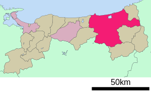
| Location Tottoris in Tottori Prefecture | ||
Tottori ( Japanese 鳥取 市 , - shi ) is a city and the administrative seat of the prefecture of the same name Tottori in the southern part of Honshū , the main island of Japan .
geography
Tottori is near the coast of the Sea of Japan .
history
Tottori is an old castle town that was last home to a branch of the Ikeda with a substantial income of 320,000 koku . The remains of Tottori Castle have been preserved.
Attractions
In addition to Tottori University, there is an electronics and metal goods industry. The city is also known for its sand dunes , which are the largest in Japan.
traffic
- Tottori Airport
- Street:
- National road 9
- National roads 29, 53, 373
- Train:
sons and daughters of the town
- Kagawa Kageki (1768–1843), Tanka poet
- Ozaki Hōsai (1885–1926), haiku poet
- Jirō Taniguchi (1947-2017), Mangaka
- Shin Taniguchi , opera singer (baritone)
Town twinning
-
 Kushiro , Japan ( Hokkaidō ) (since October 4, 1963)
 -
 Himeji , Japan ( Hyōgo ) (since March 8, 1972)
 -
 Iwakuni , Japan ( Yamaguchi ) (since October 13, 1995)
 -
 Hanau , Germany ( Hesse ) (since 2001)
 -
 Chongju , South Korea ( Chungchongbuk-Do )
 -
 Taicang , China ( Jiangsu ) (since 1995)
Neighboring cities and communities
- Tottori Prefecture
- Hyogo Prefecture
- Okayama Prefecture
Web links
Commons : Tottori - collection of images, videos and audio files


