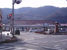
Tsuyama
| Tsuyama-shi 津 山 市 |
||
|---|---|---|
| Geographical location in Japan | ||
|
|
||
| Region : | Chūgoku | |
| Prefecture : | Okayama | |
| Coordinates : | 35 ° 4 ' N , 134 ° 0' E | |
| Basic data | ||
| Surface: | 506.36 km² | |
| Residents : | 100,387 (October 1, 2019) |
|
| Population density : | 198 inhabitants per km² | |
| Community key : | 33203-8 | |
| Symbols | ||
| Flag / coat of arms: | ||
| Tree : | Camphor tree | |
| Flower : | Rhododendron indicum , cherry blossom | |
| town hall | ||
| Address : |
Tsuyama City Hall 520 Yamakita Tsuyama -shi Okayama 708-8501 |
|
| Website URL: | http://www.city.tsuyama.lg.jp | |
| Location of Tsuyamas in Okayama Prefecture | ||
Tsuyama ( Japanese 津 山 市 , - shi ) is a city in the Japanese prefecture of Okayama .
geography
Tsuyama is located north of Okayama Prefecture , north of Okayama and south of Tottori . The northern and western parts of the city are on the edge of the Chūgoku Mountains . The mountains are 1000 to 1200 meters high.
history
Tsuyama was the castle town and capital of the Mimasaka province . The city of Tsuyama was founded on February 11, 1929 from the union of two parishes ( 津 山 町 , 津 山東 町 ) and three villages ( 西 苫 田村 , 二 宮 村 , 院 庄村 ) of Tomata County and one village ( 福岡 村 ) of Kume County . Tsuyama was not destroyed by the Pacific War, so the castle town character has been (partially) preserved.
Attractions
- In Kakuzan Park, remains of Tsuyama Castle , known for the cherry blossom.
- The Shūraku-en park , an important complex of the Edo period in the style of a garden.
traffic
- Street:
- Chūgoku Highway
- National Road 53: to Okayama and Tottori
- National roads 179, 181, 374, 429
- Train:
- JR Kishin Line
- JR Inbi line
- JR Tsuyama Line
Town twinning
-
 Santa Fe, New Mexico , United States
sons and daughters of the town
- Hiranuma Kiichirō (1867–1952), Prime Minister
- Mitsukuri Gempo (1799–1863), doctor and scholar
- Joe Odagiri (born 1976), actor
- Ōta Kaoru (1912–1998), trade unionist
- Saitō Sanki (1900–1962), haiku poet
- Kaishū Sano (* 2000), soccer player
Neighboring cities and communities
Web links
Commons : Tsuyama - collection of images, videos and audio files


