Kushiro-shi
| Kushiro-shi 釧 路 市 |
||
|---|---|---|
| Geographical location in Japan | ||
|
|
||
| Region : | Hokkaidō | |
| Prefecture : | Hokkaidō | |
| Coordinates : | 42 ° 59 ' N , 144 ° 23' E | |
| Basic data | ||
| Surface: | 1,362.75 km² | |
| Residents : | 168,436 (September 30, 2019) |
|
| Population density : | 124 inhabitants per km² | |
| Community key : | 01206-8 | |
| Symbols | ||
| Flag / coat of arms: | ||
| Tree : | Common lilac | |
| Flower : | Nasturtiums | |
| town hall | ||
| Address : |
Kushiro City Hall 7 - 5 Kurogane-chō Kushiro -shi Hokkaidō 085-8505 |
|
| Website URL: | http://www.city.kushiro.lg.jp/ | |
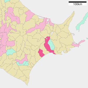
| Location of Kushiros in Hokkaidō Prefecture | ||
Kushiro ( Japanese 釧 路 市 , - shi ) is a Japanese city in the east of the island of Hokkaidō and the administrative seat of the sub-prefecture of Kushiro . Its remote location gives the city a mystical and exotic image in the rest of Japan. So she is z. B. Subject of many Japanese hits .
history
A 2 m high tsunami wave reached the port of Kushiro at 3:51 a.m. Japan Standard Time on March 11, 2011 after the Tōhoku earthquake .
geography
location
Kushiro is east of Sapporo and west of Nemuro on the Pacific Ocean . The river of the same name flows into the Pacific at Kushiro .
climate
With an average of 6 ° C, Kushiro is also the coolest city in Japan. Temperatures range from −7 ° C in January to 18 ° C in August, with 1100 mm of precipitation falling per year. Despite the location, the climate is still determined by the monsoon , which means that most of the precipitation falls in the summer months.
|
Average monthly temperatures and rainfall for Kushiro-shi
Source: wetterkontor.de
|
|||||||||||||||||||||||||||||||||||||||||||||||||||||||||||||||||||||||||||||||||||||||||||||||||||||||||||||||||||||||||||||||||||||||
traffic
To the west of the city is Kushiro Airport . The Kushiro Station lies on the Nemuro Main Line . Trains run to Sapporo and Nemuro . At the Higashi-Kushiro station in the northeast of the city, the Senmō main line branches off to Abashiri . In addition, Kushiro can be reached via national roads 38, 44, 240, 241, 274 and 391.
One of the city's landmarks is the Nusamai Bridge , which runs along National Road 38 across the Kushiro River. There are four sculptures on it that represent the seasons, making it the first bridge in Japan with statues in 1976.
Town twinning
-
 Petropavlovsk-Kamchatsky , since 1998
 -
 Burnaby , since 1965
 -
 Tottori , since 1963
sons and daughters of the town
- Yukinobu Hoshino (* 1954), manga artist
- Akira Ifukube (1914-2006), composer
- Bin Ishioka (* 1984), ice hockey player
- Satoshi Kon (1963-2010), screenwriter and anime film director
- Hiroyuki Miura (* 1973), ice hockey player
- Nakahara Teijirō (1888–1921), sculptor
- Yasuhiro Ōuchi (* 1982), ice hockey player
- Kentarō Sadamune (* 1986), ice hockey player
- Kōta Tanaka (* 1986), ice hockey player
- Kazuki Yamamoto (born 1986), ice hockey player
- Kazurō Watanabe (* 1955), astronomer
Neighboring cities and communities
Individual evidence
- ↑ 東北 沖 大 地震 : え り も で 3.5 メ ー ト ル 津 波 流 さ れ る 車 、 漁船 (そ の 1) / 北海道 ( Memento from March 15, 2011 in the Internet Archive ), Mainichi Shimbun (Japanese)
- ↑ Nusamai Bridge. In: visit Hokkaido. Retrieved December 8, 2014 .


