
2011 Tōhoku earthquake
| Tōhoku earthquake | |||
|---|---|---|---|
|
|||
| date | March 11, 2011 | ||
| Time | 05:46:23 UTC (14:46:23 local time ) | ||
| intensity | 7 on the JMA scale | ||
| Magnitude | 9.1 M W | ||
| depth | 32 km | ||
| epicenter |
38 ° 19 '19 " N , 142 ° 22' 8" E
(130 km from Sendai )
|
||
| country | Japan | ||
| Affected places |
north east coast of Honshu |
||
| Tsunami | Yes | ||
| dead | Confirmed deaths: 15,895 and 19,630; plus missing persons: 2,539 and 2,569 |
||
| Injured | over 6,156 or 6,230 | ||


The Tōhoku earthquake 2011 ( Japanese 平 成 23 年 (2011 年) 東北 地方 太平洋 沖 地震 , Heisei 23-nen (2011-nen) Tōhoku-chihō taiheiyō-oki jishin , dt. "Earthquake on the Pacific coast off the Tōhoku -Region 2011 "or 東 日本 大 震災 , Higashi-Nihon daishinsai , dt." Great earthquake catastrophe of Eastern Japan ") was a large seaquake off the Sanriku coast of the Japanese region Tōhoku . It occurred on March 11, 2011 at 2:46:23 p.m. local time (6:46:23 a.m. CET ). The epicenter was off the coast of Miyagi Prefecture about 370 kilometers northeast of Tokyo and 130 km east of Sendai and triggered tsunami tidal waves that flooded an area of over 500 km² on the Japanese Pacific coast . In terms of the extent of the affected area, it is the largest known tsunami event in Japanese history. Around 3.5% of the around 600,000 people affected by the tsunami were killed.
The number of victims is 22,199. According to statistics from the Fire and Disaster Protection Agency dated March 7, 2018, 19,630 people died in the disasters, while 2,569 were missing. According to the police, 15,895 people were reported dead as a result of the two natural disasters, while 2,539 were missing (as of March 9, 2018).
470,000 people had to be evacuated and placed in emergency shelters in the following days. Around 400,000 buildings have completely or partially collapsed.
The strength of the earthquake is given by the United States Geological Survey (USGS) with the moment magnitude 9.1 M w . According to this information, the hypocenter of the earthquake was about 32 kilometers deep. According to the Japan Meteorological Agency , the quake had a strength of 9.0 M w and 8.4 M jma ; They located the hypocenter at a depth of 24 kilometers. In Kurihara in northern Miyagi Prefecture, the quake reached the maximum intensity of 7 on the JMA scale . It is considered to be the strongest earthquake in Japan since the earthquake records began there and, in addition to the tsunami (locally up to 40 meters of incidence height was reached), indirectly or directly triggered accidents in several nuclear power plants in Eastern Japan , especially at the Fukushima-Daiichi site , in the region 14 meter high tsunami was hit. Earthquake, tsunami, and the Fukushima nuclear disaster are collectively referred to as the triple disaster .
Tectonic overview

The earthquake near the east coast of Honshū occurred as a result of a thrust on the complex plate boundary between the Pacific plate and the North American plate . In this area, the Pacific Plate moves westward at an average speed of 83 mm per year with respect to the North American Plate.
This speed of continental drift is, however, an average value that is significantly lower during normal seismic activity, until the building up tension suddenly relaxes due to an earthquake. In connection with the Tōhoku earthquake, according to initial estimates, there was a jerky movement of at least five meters.
When digging in Japan, the Pacific Plate pushes itself under the southernmost extension of the North American Plate and subducts with it further to the west under the Eurasian Plate . Some seismologists divide this region into several microplates , which in combination lead to the movements between the Pacific, North American and Eurasian plates - in particular, the Okhotsk plate and the Amur microplate are named in the respective parts of North America and Eurasia.
Since 1973, nine earthquakes with a magnitude greater than 7 have occurred during the Japanese digging. The strongest of these occurred in March 2011 with a magnitude of 9.1. An earthquake with a magnitude of 7.7 with an epicenter 75 km further west resulted in the death of 22 people and more than 400 injuries. In December 2008 four moderate earthquakes (magnitude 5.3–5.8) occurred within a radius of 20 km from the center of the Tōhoku earthquake.
The earthquake and the effects of the tsunami were compared with the Jōgan earthquake in 869 , which had a magnitude of M W 8.1 to 8.4. Other strong earthquakes in the area were the Meiji-Sanriku earthquake in 1896 and the Shōwa-Sanriku earthquake in 1933 .
course
Quake

The earthquake was preceded by a number of significant foreshocks, beginning on March 9 with an earthquake with a magnitude of 7.2 M w (the epicenter was about 40 km away from the epicenter of the Tōhoku earthquake), followed by three more earthquakes with a magnitude larger than 6.0 M w the following night.
Main quake
The quake started relatively slowly with quite strong up and down movements, also known as P waves . After an unspecified time (approx. 20 to 30 seconds), much more violent horizontal movements or S-waves were added, but these had a very low frequency, i.e. slow movement. The ground then moved in a rolling motion, comparable to the movement of a boat in moderate swell. In addition to this rolling, the tremors of the aftershocks came every minute. The main quake had a total duration of about 5 minutes.
geophysics

According to the Geoforschungszentrum Potsdam , the earth's crust tore open within three and a half minutes over a length of 400 km to a depth of 60 km. Slab movements of up to 27 m horizontally and 7 m vertically occurred. The earthquake caused extensive subsidence (subsidence) in some areas . In the city of Rikuzentakata, for example, there were subsidence of 84 centimeters. In Onahama, Iwaki, the earthquake lowered the coast by 40 cm, and on the Oshika Peninsula by up to 120 cm. This increased the risk of coastal flooding. The subsidence caused coastal areas and roads to flood during floods and often hampered local recovery and reconstruction efforts. In the Sendai plain, the risk of storm surges and floods increased significantly. The area of the area, which was below mean sea level, more than tripled from 3 to 16 square kilometers after the earthquake, according to laser profiling by the MLIT .
The earthquake moved the main island of Honshū by 2.4 meters to the east and the figure axis of the earth by 16 centimeters. In addition, the change in the mass distribution reduced the earth's moment of inertia , so that the earth has been rotating a little faster since then. The day length was shortened by 1.8 microseconds .
Seismic intensity

The area in which the earthquake was felt - with intensity shindo : on the JMA scale of 1 or higher - spanned all four main islands of Japan. The earthquake had the most severe effects in the northeast of the Tokyo area with shindo of 6-jaku ("weak 6") or higher in the following areas:
Earthquake energy
During the main quake, an energy of 3.9 × 10 22 joules was released. This corresponds to the equivalent of 77 times the global energy requirement (based on the year 2010) or, with a TNT equivalent of 9.3 × 10 3 gigatons, roughly the energy of 780 million Hiroshima bombs .
Aftershocks
| 1 week | M≥5.0 | M≥6.0 | M≥7.0 | 2 weeks | M≥5.0 | M≥6.0 | 3 week | M≥5.0 | M≥6.0 |
|---|---|---|---|---|---|---|---|---|---|
| March 11 | 120 | 30th | 3 | March 18th | 6th | 0 | 25th March | 3 | 1 |
| March 12th | 73 | 9 | 0 | 19th March | 9 | 2 | 26th of March | 2 | 0 |
| March 13th | 33 | 5 | 0 | March, 20th | 8th | 0 | 27th of March | 3 | 0 |
| the 14th of March | 27 | 2 | 0 | March 21st | 3 | 0 | 28th March | 3 | 1 |
| March, 15 | 14th | 2 | 0 | March 22 | 11 | 4th | March 29 | 1 | 1 |
| March 16 | 11 | 2 | 0 | March 23 | 11 | 1 | March 30 | 5 | 1 |
| 17. March | 12 | 0 | 0 | March 24th | 3 | 0 | March 31 | 1 | 1 |
According to data from the United States Geological Survey (USGS), the main quake was followed by numerous aftershocks. The heaviest with a magnitude of 7.9 M w occurred half an hour later at 3:15 pm (local time); him were two strong earthquakes measuring 6.4 M w to 15:06 (local time) preceded.
On April 7, another strong aftershock with magnitude 7.1 occurred 66 km away from Sendai or 40 km off the Oshika Peninsula , followed by a quake with a magnitude of 7.0 on April 11 (JMA, 6 , 6 according to USGS), but this time only 6 km off the coast of Iwaki in Fukushima Prefecture.
As of April 18, the Meteorological Bureau of Japan (JMA) recorded 423 aftershocks with a magnitude of 5.0 or more, 72 aftershocks with a magnitude of 6.0 or more, and five aftershocks with a magnitude of 7.0 or more.
Tsunami
The tsunami triggered by the earthquake hit the Japanese Pacific coast from Hokkaido to Kyūshū as well as various other regions around the Pacific Ocean.
Japan
| Municipality or part of a municipality | Flood area [%] |
|---|---|
| Rokkasho | 0 ~ 10 |
| Misawa | 0-10 |
| Oirase | 0-10 |
| Hachinohe | 0-10 |
| Hashikami | 0-10 |
| Hirono | 0-10 |
| Kuji | 0-10 |
| Noda | 20-30 |
| Fudai | 0-10 |
| Tanohata | 10-20 |
| Iwaizumi | 0-10 |
| Miyako | 20-30 |
| Yamada | 30-40 |
| Ōtsuchi | 50-100 |
| Kamaishi | 20-30 |
| Ōfunato | 30-40 |
| Rikuzentakata | 40-50 |
| Kesennuma | 30-40 |
| Minamisanriku | 50-100 |
| Ishinomaki | 40-50 |
| Onagawa | 40-50 |
| Higashimatsushima | 50-100 |
| Matsushima | 10-20 |
| Rifu | 0-10 |
| Shiogama | 30-40 |
| Shichigahama | 20-30 |
| Tagajō | 30-40 |
| Miyagino-ku (Sendai) | 10-20 |
| Wakabayashi-ku (Sendai) | 10-20 |
| Taihaku-ku (Sendai) | 0-10 |
| Natori | 10-20 |
| Ivanuma | 30-40 |
| Watari | 30-40 |
| Yamamoto | 40-50 |
| Shinchi | 20-30 |
| Sōma | 10-20 |
| Minamisōma | 10-20 |
| Namie | 10-20 |
| Futaba | 0-10 |
| Ōkuma | 0-10 |
| Tomioka | 0-10 |
| Naraha | 0-10 |
| Hirono | 10-20 |
| Iwaki | 0-10 |
| Kitaibaraki | 0-10 |
| Takahagi | 0-10 |
| Hitachi | 0-10 |
| Tōkai | 0-10 |
| Hitachinaka | 0-10 |
| Mito | 0-10 |
| Ōarai | 0-10 |
| Hokota | 0-10 |
| Kashima | 0-10 |
| Kamisu | 0-10 |
| Chōshi | 0-10 |
| Asahi | 0-10 |
| Sosa | 0-10 |
| Yokoshiba-Hikari | 0-10 |
| Sammu | 0-10 |
| Kujūkuri | 0-10 |
| Ōami-Shirasato | 0-10 |
| Shirako | 0-10 |
| Chōsei | 0-10 |
| Ichinomiya | 0-10 |


The tsunami reached mainland Japan about 20 minutes after the earthquake and affected the Japanese Pacific coast over an area of 2000 km. He was the main killer of the disaster, with most of the deaths occurring in the Tōhoku region.
The tsunami flooded an area of over 500 km² on the Pacific coast of Japan and in this respect was the largest known tsunami event in Japanese history. Of the 250,000 to 600,000 residents affected by the tsunami, depending on the information, around 3.5% or 4% were probably killed (for comparison: the Meiji-Sanriku tsunami of 1896, which occurred at night, in contrast to the Tōhoku tsunami 2011, had 40% of the population in the affected zones).
procedure
On March 11, 2011 at 2:49 p.m. local time, three minutes after the earthquake, the Japan Meteorological Agency (JMA) issued a warning - based on the initially estimated magnitude of 7.9 M jma - of a tsunami up to 6 meters high for the Coast at Miyagi Prefecture , while only 3 meters for the neighboring prefectures of Iwate and Fukushima and 0.5 to 2 meters for the remaining sections of the entire east coast of Japan . After the tsunami was registered by tsunami buoys off the coast, the JMA revised the content of the warning with assessments for the coasts of the prefectures Aomorie of 3 m, Iwate 6 m, Miyagi over 10 m, Fukushima 6 m, Ibaraki 4 m and Chiba 4 m.
Coincidentally, the day before the tsunami, the Japanese government published an information video about tsunamis, including recommendations for behavior. However, the countermeasures for a tsunami disaster proved inadequate for the 2011 tsunami. Tsunami barriers (on land and offshore breakwaters as well as natural tsunami barriers) were badly damaged, some reinforced concrete buildings were completely destroyed and the extent of the flooding in several areas was underestimated. After receiving the tsunami warning from the JMA, some residents believed they were safe behind a 10-meter-high embankment based on the 3-meter assessment and saw no reason to evacuate. Even more disastrous was the fact that radio and loudspeaker systems did not work in various communities due to power outages caused by the earthquake.
In fact, the earthquake triggered a tsunami several meters (locally up to 38 or 40 meters) high on the coasts off Sendai and Sanriku , which devastated a coastal strip hundreds of kilometers long and up to several kilometers wide. The tsunami in Japan flooded an area of 470 to 560 square kilometers, depending on the source.
Large ships washed ashore in the heavily damaged town of Hachinohe .
As with previous tsunamis, large ocean eddies formed off the coast of Oarai. An East Japan Railway Company (JR East) train derailed on the Ōfunato line in the area of Nobiru Station in Higashi-Matsushima , after which nine travelers had to be rescued from the wreck. Four other trains on the Senseki Line , Ōfunato Line and Kesennuma Line were considered missing.
Tōhoku region
The Tōhoku region is made up of various prefectures stretching to the Pacific, from Aomori and Iwate prefectures in the north to Miyagi prefecture to Fukushima prefecture in the south. Miyagi Prefecture suffered the most casualties, followed by Iwate and Fukushima Prefectures. Sendai is the largest city in the region.
- Topographic structure
The Tōhoku region has two distinct topographical forms:
The first is the Sanriku Ria coast north of the city of Sendai with a coastal location of the mountains. This northwestern part of the Pacific side of Tōhoku, known as the Sanriku Region, extends from Aomori Prefecture in the north to Miyagi Prefecture in the south. The geomorphology of this northern Tōhoku coast is characterized by the formation of Ria coasts, which thus form steep, narrow bays. A narrow continental shelf lies in front of most of the Sanriku coast. In the same way as fjords , they form an indented coastline, the "indentations" of which consist of very deep sea bays, which can enable a tsunami to concentrate its power when advancing inland and intensify the tsunami damage. These areas are mountainous, with the land rising steeply from the sea and the villages and towns lying on a very narrow strip of land just below the mountains.
The southern part of the Pacific coast of Tōhoku, on the other hand, is generally characterized by the presence of sandy beaches that merge into plains, which are mainly used for rice cultivation. These levels rise only gradually and, with the exception of the mighty coastal dykes, are often devoid of large-scale structures, which enables a tsunami to easily flood large areas. The Sendai Plain , located south of the city of Sendai, as the second topographical form of the Tōhoku region near the coast, offers little access to higher areas. In particular, this Sendai plain is - like generally the southern part of Tōhoku - relatively poor in relief or flat. Compared to the Sanriku Coast, the coast of the Sendai Plain has a wider and flatter continental shelf in front of it.
- Earthquakes and tsunamis - historical experience, risk assessment and preparation


The risk of earthquakes and tsunamis off the Tōhoku coast had been assessed as high in the run-up to the disaster. The Japanese government had reported that earthquakes with a magnitude of 7.4, 7.5 or 7.5-8.0 along a 200 km fault off the coast of Sendai in southern Sanriku-oki off Miyagi Prefecture had a probability expected by 99%. For an earthquake with a magnitude of 7.7 in this region, a probability of 70 to 80% was assumed. There had also been tsunamis-triggering earthquake disasters in the past, of which the Meiji-Sanriku earthquake in 1896 (M W 8.1 to 8.5) around 22,000 lives and the Shōwa-Sanriku earthquake in 1933 (M W 8.1 up to 8.4) claimed around 3,000 lives as a result of the effects of the earthquake and tsunami. Smaller tsunamis occurred roughly every 10 to 50 years. Since 1793, earthquakes with magnitudes between 7.4 and 8.0 had occurred off the coast of Miyagi every 37 years on average.
The local topography intensifies the tsunami height in many bays. This amplification due to trapped edge waves can also be observed along flat beaches. Therefore countermeasures against earthquakes and tsunami disasters have been taken in these areas, such as seawalls (sea walls) and tsunami gates as tsunami barriers on land, offshore tsunami breakwaters, tree plantings as natural tsunami barriers, vertical evacuation buildings and periodic evacuation training. The Tōhoku region was thus an area prepared to a large extent with countermeasures for tsunamis.
Due to the intrinsic difference between the northern part of the Tōhoku region (as the Ria Coast area) and the southern part (as the coastal plains area), the position of the protective structures in the two areas was different, which in turn influenced the damage pattern. In the northern Ria area, breakwaters were built at the entrance to some of the bays that had suffered great damage in previous tsunamis, some of which were designed for tsunami waves, while others were designed to protect against storm waves. On the southern coast of the region, however, the defenses generally consisted less of breakwaters, but mainly of coastal dikes designed to protect against storm waves. However, this southern area also had a number of small harbors that were protected by breakwaters, which resulted in a third characteristic type of damage pattern. In this way, in addition to the subdivision of the region into the northern Ria Coast area and the southern coastal plains area, which differ in terms of land use and types of coastal structures, a subdivision of the southern level into sandy beaches, which make up most of the Form coast, and small harbors are made.
Evacuation preparations were among the multitude of countermeasures that had been taken in preparation for these tsunamis to counteract the damage expected to the Sanriku coast and Sendai plains. The distinct topographical features of the Sanriku Ria coast on the one hand and the Sendai plain on the other also influence the informal evacuation strategies used in the respective areas. In the coastal area of Sanriku, the term tendenko is used for evacuation in the event of a tsunami , which propagates pure self-rescue and does not provide that the self-evacuator takes care of the evacuation of other people such as relatives, neighbors or relatives. This evacuation strategy has the advantage that people evacuate themselves without delay, which may be necessary in the case of a nearby epicenter of the quake and the associated short lead time between the main quake and the arrival of the tsunami. Due to the fact that higher ground is usually nearby in the coastal area of Sanriku, the Tendenko strategy is considered suitable for this region. The tendenko concept, however, is not used in the Sendai plain, as there is generally no higher terrain in this region. On the Sendai level, public buildings such as schools or community centers are instead used as evacuation centers. In the case of tsunami evacuation of people in high-rise buildings made of reinforced concrete (ger .: is usually reinforced concrete , RC) or building of reinforced concrete ( steel-reinforced concrete , SRC) is recommended if no mountains are as a retreat nearby. The building regulations for earthquake-proof buildings, which were revised in 1981 and 2000, did not take into account any tsunami pollution. The guideline for tsunami evacuation buildings created in 2005 contains practical instructions for the evacuation of buildings, which stipulate that with an expected tsunami flood depth of 2 m higher than on the third floor and with an expected tsunami flood depth of 3 m higher than that fourth floor is to be evacuated.
The main concern was less the plain coastline than the Ria coast with its remarkable tsunami-enhancing characteristics resulting from its V-shaped topography. In addition, the Sendai Plain was protected from the resulting tsunamis during the historic earthquakes of 1896 and 1933, because these earthquakes occurred in the north and the Sendai Plain, located within a bay on the Sanriku coast, was not in their direction of impact. In the end, the Sendai plain was assumed to have a relatively low tsunami risk compared to the Sanriku coast . It has been argued (Goto & al., 2012) that there is no historical record of a large tsunami on the Sendai and adjacent coastal plains despite corresponding seismically active regions and the recording of a few smaller tsunamis with the exception of the Keichō-Sanriku tsnamis of 1611 there was no longer a major tsunami in the region. The fact that the Sendai Plain is a low-risk area in relation to the Sanriku coast is consistent with historical records, according to which there have been no major tsunami events on the flat coast and in since the tsunami triggered by the Keichō-Sanriku earthquake in 1611 the Sendai Plain, whereas the Sanriku coast was affected by large tsunamis in 1896 ( Meiji-Sanriku tsunami ), 1933 ( Shōwa-Sanriku tsunami ) and 1960 ( Chile tsunami ). For example, the Shōwa-Sanriku tsunami, which had a maximum incidence height of 28 m on the Sanriku coast in Showa-Sanriku, reached a height of only 3.9 m in Yamamoto, and during the Meiji-Sanriku tsunami on the Sanriku Coast in Ōfunato had been recorded with a maximum run-up height of 38.2 m, the measured height in Sendai was less than 5 m.
It was countered that too little attention had been paid to evidence of large tsunamis that had previously flooded the region, as well as Japanese research suggesting that large earthquakes can occur anywhere along subduction zones, as well as recent research Megathrust earthquakes since the 2004 Indian Ocean earthquake .
Sanriku region
.jpg)
.jpg)
About 50 to 200 km north of the Sendai plain, the Ria coast, which is characteristic of the local Sanriku region, with its steep terrain and flat, narrow bays led to the fact that tsunami waves were bundled, formed the highest incidence heights and to catastrophic destruction here mostly smaller towns led, including Tarō / Miyako and Rikuzentakata in Iwate Prefecture. The Tōhoku tsunami reached its highest maximum run-up height in 2011 at 40.1 m in Ryōri Bay / Ōfunato, making it the highest tsunami ever measured in Japan. In this ria coastal region, cities were devastated between the 38th and 40th parallel. The maximum incidence height of the Tōhoku tsunami of 2011 is similar to that of the Meiji-Sanriku earthquake of 1896, but the extent of the affected coastline was exceeded by the Tōhoku tsunami in 2011 many times over. The areas in which the maximum run-up height exceeded 30 meters extended in 2011 from Onagawa (Miyagi) to Noda (Iwate) , which covered a 180 km long section of the Sanriku coast. The flood levels along the Ria coasts of the northern part of Miyagi Prefecture and Iwaze Prefecture were about twice that of the Sendai Plain. The Sanriku Coast has many V-shaped bays that cause the tsunami energy to concentrate and amplify. The V-shaped bays such as Onagawa Bay, which are wide and deep at the mouth of the bay but narrower and shallower at the end of the bay, may add to the wave height of the tsunami, depending on the topography of the seabed, as well as refraction and diffraction of the tsunami. The water flowing from the sea into the bay is compressed from left and right due to the ever increasing rejuvenation of the bay and gives way upwards, so that the sea level arches up and the wave height rises. Compared to non-tapering (rectangular) bay types and even more so compared to linear coastal sections (without indentation), this tapering bay shape (V-shape) has the highest tendency to high waves. In Onagawa, the tsunami wave rose so high that the tsunami flooded the ground floor and up to 2 m high on the first floor of the hospital at 16 m above sea level.
In the northern areas of the Sanriku Coast, the tsunami in several cases inundated four-story buildings, including some tsunami evacuation buildings, a hospital, and a local civil protection center, in communities whose tallest buildings were four or five stories. People who trusted to be safe in these buildings perished.
The cities of Rikuzentakata and Minamisanriku were almost completely destroyed by the tsunami. Thousands of people were killed here and hundreds went missing years later. In Minamisanriku, the tsunami is said to have reached a height of 16 meters. The cities of Kamaishi and Kesennuma also suffered severe devastation . Fires broke out in large parts of the city in Kesennuma. The communities of Miyako , Noda , Ōfunato , Ōtsuchi and Yamada continued to be badly damaged, with a large number of deaths .
To the south of the Sanriku coast, the tsunami in Onagawa wreaked havoc, flooding three square kilometers and 48 percent of the area in the residential areas, completely destroying around 3,000 residential buildings and killing over 870 people, of whom 258 years later remained missing . Also in the nearby city of Ishinomaki , over 20,000 buildings were completely destroyed and around 4,000 people were killed or went missing.
Flat coast, northern Sendai plain


The cities of Sendai and Ishinomaki are flat areas that are located in Sendai Bay, which is characterized by shallow water depths. The arrival time of the tsunami, which was slowed down here, was around 60 to 70 minutes after the earthquake on these coasts.
The tsunami tidal wave penetrated the Sendai Plain, the most densely populated area in the Tōhoku region with an urban center with a population of one million, consisting of fluvial lowlands and a flat coastal plain formed by the Abukuma , Natori and Nanakita rivers with a maximum of 5 kilometers inland and flooded the entire plain. The elevation of Natori or other cities in the Sendai Plain is over four kilometers inland from the coastal embankments and breakwaters near the sea level. After crossing the dams, the tsunami found no restriction in the river valleys and spread over the land surface of the Sendai Plain. Although the highest water levels in the Sendai Plain were lower than in the areas further north, a much larger area was flooded. This corresponds to the behavior of tsunamis in the area of sandy beaches / coastal plains, to which the Sendai plain belongs. In these types of coast with flat terrain and sandbanks or dunes, the tsunami tides penetrate with amoeba-like movement patterns . Although the flood height is no greater than in areas with hill geometry such as the Sanriku Coast, the area affected by the tsunami is more extensive in coastal plains. Due to the large amount of flat land, this terrain is difficult to drain and there is a risk that the flooding will last for a long time. The maximum measured flood height in the Sendai Plain was 19.50 m due to local reinforcement, while the average flood height along the Sendai coastline was around 10 meters. The airport in Sendai was flooded. In the surrounding areas, the tsunami penetrated far inland and washed away ships, cars and houses.
Flat coast, Fukushima coast, southern Sendai plain
The Fukushima coast is connected to the southern part of the Sendai Plain, so the March 11, 2011 tsunami reached it at a similar arrival time of about 60 to 70 minutes after the earthquake. The Fukushima coast differs from the Sanriku and Sendai coasts further north in terms of different topographical and bathymetric features.
To the south - in central and southern Fukushima - the coasts are no longer influenced by the shallow waters in Sendai Bay. As a result, the arrival time of the tsunami, which is here at a higher speed, was shortened to 40 to 50 minutes. Compared to the northern Sendai plain, the southern Sendai plain has a steeper and narrower continental shelf, which exacerbated the tsunami height and caused severe damage in this region, including the Fukushima Daiichi nuclear power plant. At the location of the Fukushima I nuclear power plant, the tsunami wave reached a height of 14 or - according to the operator - 15 meters, so that the 6 reactors were up to 5 meters under water.
(as of April 22, 2011):
Orange = restricted area within a 20 km radius
Yellow = "Evacuation Prepared Area"
Pink = "Deliberate Evacuation Area"

(as of June 15, 2012):
In addition to the restricted area and "Deliberate Evacuation Area", there are 3 categories:
Area 1 : Area ready for the evacuation order to be lifted
Area 2 = residents are prohibited from permanent residence.
Area 3 = unsuitable for the return of residents in the long term
| Date (2011) | Affected area | Arrangements | Official name of the zone | annotation |
|---|---|---|---|---|
| March 11, 8:50 p.m. | 2 km radius from Fukushima Daiichi nuclear power plant | Compulsory Evacuation (Issued by Fukushima Prefecture) | Restricted area | Affected area expanded in a further instruction of March 11th |
| March 11, 9:23 p.m. | 3 km radius | Compulsory evacuation (issued by 原子 災害 対 策 本部, Nuclear Emergency Response Headquarters of the Prime Minister) | Restricted area | In addition, all people within a 10 km radius should stay in the houses. Affected area expanded on March 12th |
| March 12th | 10 km radius | Compulsory evacuation | Restricted area | Affected area expanded in a further instruction of March 12th |
| March 12, 6:25 p.m. | 20 km radius | Compulsory evacuation | Restricted area | Access to the area is prohibited to anyone, with the exception of security activities and temporary access (which must be approved by the mayors of the municipalities in the region). |
| March, 15 | Between 20-30 km distance | Remain in buildings for protection | Area ready for evacuation (English: "Evacuation Prepared Area") | Self evacuation instruction added April 22nd |
| April 22 | Between 20-30 km distance | Remain inside the building for protection or evacuate yourself | Evacuation-ready area (English: "Evacuation Prepared Area" or "Evacuation Prepared Areas in Case of Emergency") | Area in which, in the event of an emergency, you will be asked to stay indoors or to evacuate. |
| April 22 | Areas with a radiation exposure in the air of over 20mSv / year | Evacuation within one month (issued by the Prime Minister's Nuclear Emergency Response Headquarters ) | Area of deliberate evacuation (English: "Deliberate Evacuation Area") | Area where there is concern that a cumulative radiation dose of 20mSv can be achieved within one year of the nuclear disaster. The residents are asked to evacuate in an orderly and planned manner (approximately within a month). The background was that a high level of radiation exposure spread through the air had been discovered outside of the 20 km perimeter evacuation zone. During this time, the government began using the 20mSv / year threshold as a basis for making evacuation recommendations. |
| June 16 | Places with a radiation exposure in the air of over 20mSv / year | Evacuation recommended | Specific spots for which evacuation is recommended ("Specific Spots Recommended for Evacuation") | In June 2011, at the request of residents, by means of house-by-house measurement of radiation values , the government began to identify hot spots as a fourth category, where radiation exposure in the air of over 20mSv / year is achieved outside the evacuation zones, and, if necessary, recommendations for to announce the (financially supported) evacuation of the house. |
| 30. September | Between 20-30 km distance | Cancellation of the order to remain in buildings for protection or to evacuate under one's own steam | Cancellation of the area ready for evacuation | - |
Associated with the earthquake and tsunami, the evacuations that followed the Fukushima nuclear disaster marked a sharp turning point for over 164,000 people in Fukushima Prefecture. Within a week of the nuclear accident, 8% of the total population of 2 million in Fukushima had to move to another location within or move outside of Fukushima Prefecture. As a countermeasure to the nuclear disaster, a restricted area was designated around the Fukushima Daiichi nuclear power plant within a radius of 20 km. However, there were also many other locations with high radiation values beyond this 20 km radius, as radioactive particles were carried away from the damaged power plant by the wind. These locations included 11 villages and towns, including the major city of Minamisōma , the small towns of Naraha and Tomioka , the village of Kawauchi , the small towns of Ōkuma , Futaba and Namie , the villages of Katsurao and Iitate, and the small towns of Tamura and Kawamata .
In the days and weeks after the nuclear accident, around 85,000 people from 12 communities were forced to move out of the areas within the 20 km radius of the nuclear power plant ("Restricted Area") and from heavily contaminated areas outside this zone ("Deliberate Evacuation Area"). to evacuate. After it was confirmed in December 2011 that the situation in the nuclear reactors had stabilized and that safety in the nuclear power plant was guaranteed, the rearrangement of the evacuation areas began. The evacuation areas were divided into three areas: "Area 1" ("Areas to which evacuation orders are ready to be lifted"), "Area 2" ("Areas in which the residents are not permitted to live") and "Area 3" ( "Areas where it is expected that the residents have difficulties in returning for a long time"). According to other information, the two zones of the “Restricted Area” and the “Deliberate Evacuation Area” were rearranged at the end of November 2012 into the three areas “Area 1”, “Area 2” and “Area 3” according to their radiation exposure in the form of the annual accumulated dose. According to the evacuation orders of May 7, 2013, these regions were divided into the following four different categories according to their radioactive exposure: Areas with a radiation exposure of less than 20 mSv per year, which were treated by the government as a threshold value for permanent return the area 1 . Areas in Area 1 could be entered at their own discretion and without the use of protective equipment, with the only restriction that they were not allowed to stay overnight there. These areas were ready for the evacuation order to be lifted. In areas with a radiation exposure between 20 and 50 mSv per year ( Area 2 ), residents were not allowed to stay permanently. Areas with over 50 mSv per year ( Area 3 ) were seen as unsuitable for a return of residents in the long term. A fourth evacuation area had a special status.
Accordingly, the Sōsō region in the northeast of Fukushima prefecture , which also includes the city of Minamisōma and the cities of Shinchi and Hirono and has a total of 200,000 inhabitants, was one of the regions of Japan most severely affected by the triple disaster . By February 2013, around 57,000 residents of Fukushima Prefecture had been evacuated to other prefectures and around 100,000 people had moved to other areas within the prefecture to protect their children from radioactive pollution . As of December 2014, 120,000 people, around half of all 234,000 evacuated due to the triple disaster, came from Fukushima prefecture. Around 75,000 evacuees had changed their place of residence within Fukushima Prefecture and were living in makeshift shelters, communally subsidized rental apartments or with a relative or friend. About 45,000 had moved from Fukushima to other parts of Japan. Among the three prefectures affected by the disaster, the number of people who had moved to a region outside their home prefecture was highest for those from Fukushima Prefecture (45,934 versus 6,810 from Miyagi Prefecture and 1,453 from Iwate Prefecture) .
After extensive decontamination work was carried out at enormous cost, the evacuation areas could be changed from their original distribution. In mid-2014, of the 80,000 evacuated from the evacuation zones, 32,000 (40%) were classified as “Area 1”, 23,000 (29%) as “Area 2” and 25,000 (31%) as “Area 3” Areas where 50,000 others were voluntarily evacuated, 21,000 from the Evacuation Prepared Areas in Case of Emergency and 29,000 from other parts of Fukushima. At the end of November 2016, the decontamination work in most of the evacuation areas, with the exception of “Area 3”, had been completed and the evacuation orders for five communities had been lifted. On March 31 and April 1, 2017, the Japanese government revoked the evacuation orders for around 32,000 residents from the four radiation-contaminated communities of Iitate, Kawamata, Namie and Tomioka, allowing them to return to their homes. The only places that were still the subject of evacuation orders were Futaba and Ōkuma and parts of the five neighboring towns and villages Minamisōma, Iitate, Namie, Tomioka and Katsurao.
While much research into catastrophic damage in the Sanriku region in Iwate and Miyagi Prefectures has been conducted and published, studies in Fukushima Prefecture have been limited due to the evacuation from the nuclear disaster at the Fukushima Daiichi Nuclear Power Plant. The first of these scientific studies after the nuclear disaster in Fukushima Prefecture was published in 2013 and examined tsunami heights using tsunami tracks on the coast in the evacuation zone within a radius of 20 km from the Fukushima Daiichi nuclear power plant. Several follow-up examinations were carried out in Minamisōma, north of the Fukushima Daiichi nuclear power plant, and in the towns of Nakoso and Naraha, located south of the nuclear power plant. Field studies in Minamisōma after the Tōhoku tsunami of 2011 were delayed by 15 months in the restricted area established as a result of the high radiation exposure resulting from the multiple core meltdowns in the Fukushima Daiichi nuclear power plant .
The highest tsunami track was found at a height of 21.1 m TP on a coastal cliff in Tomioka, 7 km south of the Fukushima Daiichi nuclear power plant. The investigations revealed that the distribution of tsunami heights on the coast in Fukushima prefecture was strongly influenced by complex offshore bathymetry. They showed that increased tsunami heights in the coastal areas can be traced back to the reflection of ocean waves, funnel formation, splash-up effects on rocks and dykes / breakwaters, as well as to the increased flow resistance that the tsunami had when passing the pine forests on the coastline . Therefore, tsunami heights of 10 m were limited to the areas up to 500 m from the coast. On land, the maximum flood levels were dependent on the topography. While the inland tsunami heights continued to rise in the steeply rising V-shaped valleys, they fell as the flooding distance increased along the flat coastal plains. The flood level was higher behind completely destroyed dykes than behind partially damaged coastal protection systems. Compared to the Sendai Plain, the tsunami heights on the Fukushima coast were increased due to the convex coastline and the associated bathymetry off the coast, which tends to concentrate the tsunami energy.
Results of the Tōhoku disaster

b): Tsunami flood heights 1896 , 1933 , 1960
c ): Tsunami wave heights (Tōhoku disaster 2011)
d): Estimated casualty rates (dead / missing) per community (Tōhoku- Disaster 2011)
e): Height of breakwaters and corresponding tsunami height per location (Tōhoku disaster 2011)
The earthquake and tsunami disaster of 2011 is the first case in which modern, well-developed tsunami countermeasures were subjected to the suitability test of such an extreme event. The countermeasures for tsunami disasters proved inadequate for the 2011 event. Tsunami barriers were badly damaged, some reinforced concrete buildings were completely destroyed, and the extent of the flooding had been underestimated in some areas.
It also found that many evacuation facilities in the Tōhoku area, such as schools, were unsuitable for the needs of people who were held there for many days. There was no food and water, blankets or bedding provided on their premises, even though winter temperatures in large parts of the Tōhoku region were near freezing after the earthquake. In addition, there was often neither sanitary facilities nor access to first aid or emergency medicine, and some elderly and injured tsunami survivors succumbed to the difficult conditions at such evacuation sites after a long period of time. The 2011 tsunami also showed that the 2005 tsunami evacuation building guideline may be inadequate. Reinforced concrete buildings were overturned, six of them in the city of Onagawa and two each in Akamae (village), Miyako (city), uchtsuchi (city) and Rikuzentakata (city), none of which was designed for a tsunami evacuation building and none for tsunamis .

As a result of the fact that before the Tōhoku earthquake of 2011, the greatest earthquake risk in Japan was mainly a possible Miyagi-oki earthquake with a magnitude between 7.5 and 8.0, for which there was a probability of 99% was assumed within 30 years, the tsunami countermeasures taken in Miyagi Prefecture were not sufficient for the following Tōhoku earthquake of 2011 with a magnitude of 9.0 M w . Before the Tōhoku earthquake in 2011, tsunami hazard maps were drawn up for all districts along the Tōhoku coast, but the extent of the flood plains in some areas, such as Sendai and Ōfunato, far exceeded the maximum flood plains predicted in these maps. For example, the Minamisanriku tsunami hazard maps assumed that the expected Miyagi earthquake would cause a smaller tsunami flood area in the city than the Chile earthquake of 1960. Some parts of the resettlement areas to which the population had been resettled after the Shōwa tsunami in 1933 to protect against tsunamis following the reconstruction plan, even those on higher ground, were severely damaged by the unexpected extent of the tsunami. For example, Ryōishi (両 石 町) in Kamaishi , where the tsunami reached a height of 21.2 m instead of the run-up height of 9.5 m (Shōwa-Tsunami 1933). In Osabe in Rikuzentakata, the hill and seawall built after the Shōwa tsunami in 1933 failed to protect the community from the 2011 tsunami. The 2011 tsunami in these locations far exceeded the scale of the Meiji 1896 or Shōwa 1933 disasters.


After the tsunami it was remembered that in northern Japan there are hundreds of waystones warning of the dangers of tsunamis, some older than 600 years. Tsunami memorials such as stone memorials can be found in many areas along the Sanriku Coast, some of which were destroyed by the Tōhoku tsunami in 2011, such as in Minamisanriku. Many memorial shrines along the Pacific coast of the prefectures Iwate, Miyagi and Fukushima, however, survived the Tōhoku tsunami in 2011 and were erected in locations that were considered safe with the experience of historical tsunamis such as the Keichō-Sanriku tsunami of 1611. For example in the village of Aneyoshi in Miyako, where the 2011 tsunami stopped shortly before the tsunami memorial.
During the tsunami of 2011, high-density coastal dike breaches occurred in the southern part of the Sendai Bay coast, with Yamamoto Bay being a particular focus. Due to the unexpected height of the tsunami and its accumulation, many evacuation buildings and shelters failed to serve as a lifesaver. The three places with the worst location in the entire Tōhoku region of the evacuation and refuge locations that were flooded by the tsunami instead of protecting lives were Rikuzentakata (35 of 68 places were flooded), Onagawa (12 of 25 places were flooded) and Minamisanriku (31 of 78 were flooded), where there were high fatalities between around 5 and 12 percent in the towns. The average value of the victim rate (proportion of dead and missing in the population at the time of the 2010 census) in the tsunami flood areas along the Sanriku coast was 4.55 percent, which is much higher than in the tsunami flood areas along the flat coast of the prefectures Miyagi and Fukushima.
Significance for disaster and coastal protection
Developments before the Tōhoku disaster in 2011


Above: the quay wall upstream breakwater (. English breakwater )
Middle: coastal dike (. English coastal levee , sea dike )
Below: located behind the quay wall seawall (English: seawall )
The region affected by the disaster had often suffered devastating damage from tsunamis in the past, for example the Meiji-Sanriku tsunami in June 1896, the Shōwa-Sanriku tsunami in March 1933 and the Chile tsunami in May 1960. Before the Shōwa-Sanriku tsunami in 1933 countermeasures were limited to relocations to higher terrain.
The Shōwa-Sanriku tsunami of 1933, in which 3,000 (or: 4,000) people were killed, was the first disaster that modern tsunami countermeasures had triggered on the initiative of the central government and the prefectural governments. These countermeasures essentially comprised the relocation to higher terrain and, to a limited extent, the construction of dykes. After the Shōwa-Sanriku tsunami in 1933, the Japanese government initially implemented an integrated disaster risk management system by focusing on evacuation planning and resettlement. Since both the scientific and technological status and the availability of financial resources had not yet enabled the construction of appropriate dikes, tsunami countermeasures at that time had to rely on self-help and mutual help rather than public aid. Three months after the Shōwa-Sanriku tsunami in 1933, the Council for Disaster Reduction (CEDP) of the Ministry of Education proposed an overall system for tsunami disaster control with 10 countermeasures: relocation of residential buildings to higher terrain, establishment of coastal dykes, tsunami regulation forests, dams / breakwaters, Tsunami-resistant areas, buffer zones, evacuation routes, tsunami monitoring, tsunami evacuation and memorial events. The reconstruction plan created by the Japanese government called for resettlement in 102 villages in Miyagi and Iwate prefectures. Due to the high construction costs, coastal dikes were only built at five locations. The government was unable to fully implement its policy of reconstruction on higher ground after the Shōwa-Sanriku tsunami in 1933 due to difficulties in finding suitable terrain. Following the Shōwa tsunami, 60 villages in Miyagi Prefecture (11 community and 49 individual relocations) and 38 villages in Iwate Prefecture (all community relocations) carried out relocations, all of which were completed within one year. In 1941 an organization for tsunami warnings for the Sanriku coast was founded with the result of a tsunami forecast system that was extended to the entire coast of Japan by the Japan Meteorological Agency (JMA) in 1952 and, after the Chile tsunami of 1960, tsunamis with origins far away considered. For the transmission of tsunami warnings, Japanese cities typically have an extensive network of loudspeakers in the streets, often operated centrally - for example by the city administration - which is otherwise used for daily official announcements, but warnings throughout the city in the event of a tsunami can transmit, including spoken messages in addition to a siren tone.
In the further course, the Japanese government's policy had shifted more to structural measures such as an infrastructure-based warning system and had been technology-oriented towards rapid economic growth after the 1960s. Science, technology and infrastructure had developed strongly. The Chile tsunami of 1960 triggered the extensive construction of coastal dikes in the region. The tsunami countermeasures in Japan after the Chile tsunami of 1960 were mainly limited to the construction of breakwaters / dykes and coastal dikes, the dyke height of which was initially based on the tsunami height of the Chile tsunami of a maximum of 3 to 6 meters, but was later overtaken several times to take into account other significant tsunamis of the previous 120 years as well as predictions of future storm surge levels. The levees were designed to withstand the greatest predicted tsunami heights and storm surge levels. While the projected heights in Iwate Prefecture and northern Miyagi were based on historical records, in southern Miyagi and Fukushima Prefecture they were based on predicted storm surges. The rapid economic growth resulting from the Income-Doubling Plan started in 1960 was able to cover the high construction costs. By the time the Tōhoku tsunami hit eastern Japan in March 2011, coastal dykes had been built with a total length of 300 km and a height of up to 15 m, 270 km of which by the prefectural governments (supported by state subsidies that covered two thirds of the costs), who had the main responsibility for building the dykes, and 30 km from the national government. The state government had also developed technical standards, guidelines and manuals for the design and construction of coastal structures. While the population of Japan had increased from 72 million to 125 million in the five decades since the end of World War II , the coastal protection structures, which now stretched to a third of the Japanese coastline, made it possible for a larger number of people to live and work directly by the sea. At the time of the 2011 disaster, Japan, with its coastal defense structures (breakwaters, coastal dykes and sea walls), was seen as the state whose coast was best prepared to withstand a strong tsunami. The massive, free-standing breakwaters built in the bays were supposed to protect the industrial ports and their people. The sea dikes built in large parts of the coastal plain were intended to protect low-lying agricultural areas and cities from tsunamis and storm surges. And the tsunami walls ( seawalls ), some of which were 10 m or more high, were built to protect populated settlements due to previous tsunamis.
Probability and weaknesses during the 2011 Tōhoku disaster
Before the 2011 Tōhoku disaster, Japan was known as a world leader in tsunami disaster management. With the serious impact of the tsunami - especially in the Tōhoku region, but also in other regions from Hokkaido in the north to Tokyo in the south, the tsunami event revealed many hidden weaknesses in Japan's countermeasures for tsunami disasters. The 2011 Tōhoku disaster was the first real-life test of the various technologies and countermeasures that Japan used to protect people during the tsunamis. It turned out that some measures worked well while others appeared to have failed. Some cities such as Fudai were found to be well protected by their structures, even though the tsunami far exceeded the height for which they were designed. Some breakwaters like the one in Kamaishi Bay were able to at least reduce or delay the damage caused by the tsunami. Using the example of the city of Hirono (Iwate Prefecture), it can be shown that the dikes were able to successfully protect the communities in Japan as long as the tsunami triggered by the earthquake was lower than the dikes. While the tsunami in the city of Hirono was 9.5 m above the tide level, the levees here were 12 m higher than the tide level and the city of Hirono was not flooded.
However, the height of the tsunami waves, which were generated by the unexpectedly high magnitude of the Tōhoku earthquake, generally resulted in the coastal defense structures and other coastal structures being overused and in many cases completely or partially destroyed. Many seawalls and levees had been built to protect coastal cities from tsunamis, with the Meiji-Sanriku tsunami of 1896 being used as the basis for structural design. However, the more than 10 m high Tōhoku tsunami 2011 overcame the tsunami defense systems and damaged them considerably. Of the total of 300 km of dykes along the 1,700 km coastline of the prefectures Iwate, Miyagi and Fukushima, 190 km were destroyed or badly damaged. In many cases the tsunami was twice as high as the levees. In addition, breakwaters were destroyed over a calculated total distance of around 8.5 km, including well-known breakwaters in the bay of Kamaishi that were built at the greatest depths worldwide. All ports along the Pacific coast of the Tōhoku region from Aomori to Ibaraki suffered considerable damage to their breakwaters, quays and other coastal facilities, which temporarily suspended all port functions. In addition to the direct attack from the coast, the tsunami accrual caused significant damage along important rivers in the region such as in Ishinomaki, from where the tsunami left tracks 49 km upstream of the Kitakami and flooded 73 square kilometers or 13 percent of the total city area. The flooding of the coastal protection structures in the Fukushima Daiichi nuclear power plant led to the loss of seawater pumps for the nuclear reactor cooling water and thus ultimately to the release of large amounts of radioactive material.
Experience with the 2011 Tōhoku disaster shows that the population tended to rely too heavily on government, science and technology, such as the warning system and levees. In some cities, evacuation was delayed because people did not expect a tsunami to flood a dam up to 10 meters high. Some people were unable to escape the tsunami in time because - given the perceived security of the supposed protection of the construction of high dams - they had relocated their houses in the lowlands along the coast to be closer to their source of income. In fact, the initial information from the tsunami warning was incorrect and the dyke heights designed for the tsunami heights of the Chilean tsunami were not high enough. This was one of the factors behind the high number of victims in the population. These countermeasures were found to be inadequate and even exacerbated the negative consequences for people once the scale of the disaster exceeded the intended scope of the countermeasures. In the event that the design limits of the Antitsunami structures were exceeded by the forces of nature, the excessive dependence on structural measures turned out not only to be inefficient, but even to be disadvantageous. As a lesson, it can be concluded that the population should not rely solely on coastal infrastructure for their protection.
Due to the non-structural tsunami countermeasures on the endangered Japanese coasts, i.e. comprehensive tsunami warning systems and well-studied evacuation plans, the number of victims remained relatively limited in comparison to the destruction caused by the tsunami.
Developments and changes as a result of the Tōhoku disaster in 2011
After the catastrophe of 2011 a return to the importance of a balanced mix of structural and non-structural countermeasures began. The 2011 Tōhoku earthquake was the first disaster in recent history of Japan to exceed all expectations and predictions. The dimensions of the disaster had not previously been taken into account. The enormous impact of the disaster prompted the Japanese government to change the paradigm in disaster risk management, transitioning from a structurally-oriented prevention strategy to a damage reduction strategy in which structural and non-structural measures were integrated.


1. reinforced dyke base construction
2. thicker dam crest and landslide reinforcement of the dike flanks
3. reinforced connections between the reinforced sections. (Source: MLIT)


After the Tōhoku disaster in 2011, the Japanese government introduced two categories of disasters and tsunami threats ( level 1 or prevention level and level 2 or preparedness / mitigation level ):
- A Category 1 disaster or tsunami has a relatively high statistical probability (once in 100 years or less) and causes significant damage. The government's strategy in the event of a Category 1 tsunami is to prevent damage through coastal protection measures such as the construction of seawalls at the height of a Category 1 tsunami or appropriate breakwaters. In the case of Category 1 tsunamis, conventional structural tsunami countermeasures, such as levees and breakwaters, are effective in protecting people's lives and property, and preserving local economic activity.
- Disasters such as category 2 tsunamis (including the Tōhoku catastrophe 2011) occur with a lower statistical probability (only about once every 1,000 years), but harbor the risk of devastating destruction. In the case of level 2 events, it should be made possible to counter even extreme events with a low probability and high impact through an integrated disaster risk management strategy that combines structural and non-structural measures such as coastal protection, urban planning, evacuation and public awareness-raising. Strategies for Category 2 events should focus on saving lives. The strategy in the event of a Category 2 tsunami is to limit the damage through measures such as land use regulations and tsunami warning systems. Tsunamis of this category can no longer be countered mainly by means of disaster protection structures, but they require an integrated disaster risk management strategy that combines structural and non-structural measures. The measures that are designed to ensure immediate evacuation in an integrated manner include disaster forecasts and early warning systems, land use planning, designated evacuation sites, shelters and other facilities and structures to delay and weaken the tsunamis. Disaster education, exercises and mutual assistance mechanisms are also seen as extremely important.
In the first years after the tsunami of 2011, many improvements were implemented in both structural (numerical simulations, coastal protection structures, building damage assessment, coastal protection forests) and non-structural measures (warning and observation systems, evacuation).
Structural countermeasures
- Coastal protection structures
During the Tōhoku disaster in 2011, disastrous damage occurred when structures were flooded by the tsunami, reached their limits and suddenly collapsed. The lesson learned from this is that structures must be strong enough to withstand or gradually give way, even if natural forces exceed their structural design constraints. Even in the event of a very large tsunami, the tsunami counter-defense systems should be designed in such a way that they remain in place even in the event of flooding and help at least reduce the effects of the tsunami. In order to withstand Category 2 tsunamis, coastal structures must be improved so that their susceptibility to fracture and their complete destruction by undercutting is reduced.
During the Tōhoku tsunami in 2011, the cause of the failure of coastal dikes was in most cases due to the fact that they were flooded by the tsunami and then their unreinforced dyke base was washed away. Around 87 percent of the dykes that had already been strengthened against undercutting were not damaged by the Tōhoku tsunami in 2011, even though they had been flooded. Although the phenomenon of the dike foot being washed under was already known from the Tokachi earthquake of 1968 , the engineers at the time concluded that the dykes only had to be built sufficiently high. After the Tōhoku tsunami of 2011, construction of the new levees along the entire Tōhoku Pacific coast began. But it was now considered financially impossible to design the coastal dikes so high that they would prevent a tsunami from flooding at the highest possible height, and the effects of such tall structures that would separate the fishing and tourism industries from the sea were undesirable. Instead, the new generation of dikes ( nebaritsuyoi dyke) featured a large number of design improvements aimed at preventing or at least delaying the dam failure. The nebaritsuyoi dyke was designed to prevent flooding from a Category 1 tsunami. They were expected to be flooded by Category 2 tsunamis, but even if they were designed to be flooded, their design should be able to withstand the forces of the tsunami or last longer to allow more time for the population at risk to evacuate.
Nebaritsuyoi construction was also developed and applied to breakwaters after the 2011 tsunami, such as the Kamaishi breakwater. For other large breakwaters such as in Hachinohe, Kuji, Onagawa and Sōma, a new building in a similar nebaritsuyoi manner was also decided. As with the Ōfunato breakwater, which is also located in the mouth of a bay, it was decided to build a new one in order to reduce the likelihood that the breakwater caissons could slip. In addition, the central opening of the breakwaters was reinforced when these two breakwaters were built in Kamaishi and Ōfunato.
- Coastal forests
The Reconstruction Agency (Japanese: 復興 庁 ; English: Reconstruction Agency, RA) announced after the disaster that it would use coastal forests to rebuild coastal areas. In the Sendai Plain, a multi-layer countermeasure to reduce the effects of the tsunami was started, combining a seawall with a coastal forest and raised land or roads. An example of this strategy offers the city Iwanuma, where the plan several heaped from tsunami debris evacuation hill ( Millennium Hope Hills , + 11m TP ), an elevated road (+ 4-5m TP), a garden path (+ 3m TP) and an existing artificial Canal (Teizanbori) as the first large-scale social implementation against tsunamis in Japan.
Non-structural countermeasures
- Land use changes and relocations
The plans of the Japanese and local governments to physically rebuild the areas affected by the tsunami take into account tsunamis of category 1 and 2 and consider policy measures to change land use and relocate people in the affected areas to higher ground as well as the backfilling of hills in low-lying areas. Due to the periodically recurring tsunamis in the Tōhoku region, the resettlement of people from tsunami-prone areas was part of the reconstruction process. Although both land use regulations in coastal areas and resettlement of the population in higher areas are discussed after each tsunami disaster and people from the affected areas moved to higher terrain after each disaster, such as in 1896, 1933 or 1960, these measures usually fail because that over time people will return to the lower-lying and tsunami-prone areas near the sea. There are a variety of reasons for this return, such as population growth , demands from the fishing industry. The reconstruction plan after the Tōhoku disaster in 2011 is very similar to the reconstruction plan after the Shōwa tsunami disaster of 1933. One difference is that the post-2011 reconstruction plan provides for a seawall to ward off a Category 1 tsunami, while the Shōwa reconstruction plan focused on relocations to higher terrain to limit damage. After the Tōhoku tsunami of 2011, the government issued new guidelines for the reconstruction of river and coastal structures, which, in addition to their external design, also took into account local characteristics, ecosystems, aspects of sustainability and financial feasibility.
- Tsunami warning system
After the Tōhoku disaster in 2011, the JMA subjected all of its warning strategies to an investigation in order to improve the tsunami warning system. As a result of this, the JMA summarized three solution areas for the improvement of the tsunami warning system in the areas of basic strategy, technical improvements and improvements in their official announcement and expressions. The changes in the basic strategy stipulated that the first warnings should in future be distributed as quickly as possible, preferably within the first three minutes, and should be based on the worst possible case . In the case of updated messages, previous, underestimated values should no longer appear. The technical improvements include high-resolution flood forecasts that take into account the effects of highways. The improvements in the terminology and content of the announcements were aimed at making the tsunami warnings easier to understand. Instead of the previously eight different predicted tsunami classes, the new version only differentiates five. In addition to the numerical values, the tsunami height should also be described conceptually in future (“huge” for 5 m, 10 m and ≥10 m, “high” for 3 m and “(N / A)” for 1 m).
Russia
The tidal wave reached mainland Russia with a maximum wave height of 40 cm in the Primorye region and 80 cm in the Kamchatka region . The highest measured wave heights of the tsunami in Russia were reported by the islands of Sakhalin Oblast : Malokurilskoje : 3 m; Yuzhno-Kurilsk : 1.89 m; Kurilsk : 0.56 m; Burewestnik : 2 m, Severo-Kurilsk : 1.6 m; Poronaisk : 0.85 m; Starodubskoje : 0.65 m; Nevelsk : 0.27 m; Cholmsk : 0.22 m; Uglegorsk : 0.18 m; Korsakov : 0.67 m; Krilon : 0.29 m.
Rest of the Pacific
The Pacific Tsunami Warning Center issued warnings of the arrival of a tsunami for almost the entire Pacific Ocean ; these warnings included Japan, Russia , Marcus Island , the Northern Mariana Islands , Guam , Wake , Taiwan , the Yap Islands , the Philippines , the Marshall Islands , Palau , the Midway Islands , Pohnpei , Chuuk , Kosrae , Indonesia , Papua New Guinea , Nauru , the Johnston Atoll , the Solomon Islands , Kiribati , Howland Island , Baker Island , Hawaii , Tuvalu , Palmyra , Vanuatu , Tokelau , Jarvis Island , Wallis and Futuna , Samoa , American Samoa , Tonga , the Cook Islands , Niue , Australia , Fiji , New Caledonia , Mexico , Kermadec Islands , French Polynesia , New Zealand , Pitcairn , Guatemala , El Salvador , Costa Rica , Nicaragua , Antarctica , Panama , Honduras , Chile , Ecuador , Colombia , Peru as well as Alaska , the west coast of Canada and the west coast of the United States States .
The tsunami spread across the Pacific at a speed of 800 km / h. The Red Cross warned due to the initial information before it, that the tsunami amplitude could be greater than the maximum height of many islands in the Pacific Ocean.
At least one person drowned in California and the tsunami caused damage from Crescent City to Santa Cruz , which, according to a preliminary forecast, amounted to 36 million euros.
In Papua New Guinea, a man drowned when he was hit by a wave and washed out to sea.
Overview of wave height and arrival time
| Measuring point | State / Territory | Coordinates | arrival time | amplitude |
|---|---|---|---|---|
| Ōfunato , Iwate | Japan | 06:18 | ≥8.0 m * | |
| Ishinomaki , Miyagi | Japan | 06:20 | ≥3.3 m | |
| Kamaishi , Iwate | Japan | 06:21 | ≥4.1 m | |
| Miyako , Iwate | Japan | 06:26 | ≥8.5 m * | |
| Sōma , Fukushima | Japan | 06:50 | ≥7.3 m | |
| Hanasaki, Nemuro, Hokkaidō | Japan | 43.3N 145.6E | 06:56 | 1.83 m |
| Nemuro , Hokkaidō | Japan | 06:57 | 2.8 m | |
| Tokachi , Hokkaidō | Japan | 06:57 | ≥2.8 m | |
| Urakawa , Hokkaidō | Japan | 07:42 | 2.7 m | |
| Ōarai , Ibaraki | Japan | 07:52 | 4.2 m | |
| Omaezaki , Shizuoka | Japan | 34.6N 138.2E | 08:18 | 1.42 m |
| Naha , Okinawa | Japan | 26.2N 127.7E | 09:01 | 0.25 m |
| Saipan | United States | 15.2N 145.7E | 09:16 | 0.65 m |
| Mutsu , Aomori | Japan | 09:16 | 2.9 m | |
| Wake up | United States | 19.3N 166.6E | 09:28 | 0.39 m |
| Tosashimizu , kochi | Japan | 32.8N 133.0E | 09:46 | 0.84 m |
| Yap | Micronesia | 9.5N 138.1E | 10:13 | 0.15 m |
| Adak , Alaska | United States | 51.9N 176.6W | 10:34 | 0.35 m |
| Midway Islands | United States | 28.2N 177.4W | 10:48 | 1.27 m |
| Nikolski , Alaska | United States | 52.9N 168.9W | 11:09 | 0.27 m |
| Kwajalein | Marshall Islands | 8.7N 167.7E | 11:11 | 0.55 m |
| Legazpi City | Philippines | 13.1N 123.8E | 11:16 | 0.25 m |
| Shemya, Alaska | United States | 52.7N 174.1E | 11:36 | 1.58 m |
| Nauru | Nauru | 0.5S 166.9E | 11:56 | 0.20 m |
| Dutch Harbor, Alaska | United States | 53.9N 166.5W | 12:04 | 0.41 m |
| Johnston Atoll | United States | 16.7N 169.5W | 12:06 | 0.20 m |
| Tern, French Frigate Shoals | United States | 23.9N 166.3W | 12:24 | 0.38 m |
| Betio , Tarawa | Kiribati | 1.4N 172.9E | 12:25 | 0.21 m |
| Saint Paul Island, Alaska | United States | 57.1N 170.3W | 12:28 | 0.65 m |
| Barbers Point, Hawaii | United States | 21.3N 158.1W | 13:08 | 0.70 m |
| Kahului , Maui | United States | 20.9N 156.5W | 13:27 | 1.74 m |
| Nawiliwili, Kauai | United States | 22.0N 159.4W | 13:43 | 0.76 m |
| Hilo , Hawaii | United States | 19.7N 155.1W | 14:09 | 1.41 m |
| Honolulu , Oahu | United States | 21.3N 157.9W | 14:10 | 0.71 m |
| Kawaihae, Hawaii | United States | 20.0N 155.8W | 14:13 | 1.22 m |
| Manus | Papua New Guinea | 2.0S 147.4E | 14:25 | 0.93 m |
| Canton | Kiribati | 2.8S 171.7W | 14:25 | 0.05 m |
| Honiara | Solomon Islands | 9.4S 160.0E | 14:36 | 0.26 m |
| Kiritimati | Kiribati | 2.0N 157.5W | 14:47 | 0.56 m |
| Winter Harbor, British Columbia | Canada | 50.7N 128.3W | 15:05 | 0.47 m |
| Subic Bay | Philippines | 14.8N 120.3E | 15:17 | 0.07 m |
| Lombrum, Manus | Papua New Guinea | 2.0S 147.4E | 15:29 | 1.04 m |
| Kaumalapau, Hawaii | United States | 20.8N 156.9W | 15:31 | 0.91 m |
| Luganville | Vanuatu | 15.5S 167.2E | 15:37 | 0.54 m |
| Langara Point, British Columbia | Canada | 54.2N 133.1W | 15:39 | 0.52 m |
| Arena Cove, California | United States | 38.9N 123.7W | 15:40 | 0.82 m |
| Vanuatu | Vanuatu | 17.8S 168.3E | 15:42 | 0.69 m |
| Lautoka | Fiji | 17.6S 177.4E | 15:45 | 0.33 m |
| Charleston , Oregon | United States | 43.3N 124.3W | 15:45 | 0.49 m |
| Humboldt Bay | United States | 40.8N 124.2W | 15:53 | 0.54 m |
| Pago Pago | American Samoa | 14.3S 170.7W | 15:56 | 0.34 m |
| Port San Luis, California | United States | 35.2N 120.8W | 16:54 | 1.88 m |
| Crescent City , California | United States | 41.7N 124.2W | 16:57 | 2.02 m |
| Port Orford, Oregon | United States | 42.7N 124.5W | 17:24 | 1.85 m |
| Bitung | Indonesia | 0.4N 125.2E | 17:27 | 0.26 m |
| San Francisco, California | United States | 37.8N 122.5W | 17:49 | 0.64 m |
| Nuku'alofa | Tonga | 21.1S 175.2W | 17:51 | 0.37 m |
| Adak, Alaska | United States | 51.9N 176.6W | 17:55 | 1.09 m |
| Point Reyes, California | United States | 38.0N 123.0W | 18:10 | 1.38 m |
| Rarotonga | Cook Islands | 21.2S 159.8W | 18:13 | 0.29 m |
| Rangiroa | French Polynesia | 14.9S 147.7W | 18:22 | 0.29 m |
| Papeete , Tahiti | French Polynesia | 17.5S 149.6W | 18:22 | 0.39 m |
| Nuku Hiva , Marquesas | French Polynesia | 8.9S 140.1W | 18:24 | 1.48 m |
| Cabo San Lucas | Mexico | 22.9N 109.9W | 19:06 | 0.22 m |
| Westport , Washington | United States | 46.9N 124.1W | 19:20 | 0.62 m |
| North Cape | New Zealand | 34.4S 173.0E | 20:01 | 0.25 m |
| La Jolla, California | United States | 32.9N 117.3W | 20:07 | 0.43 m |
| Monterey Harbor, California | United States | 36.6N 121.9W | 20:13 | 0.72 m |
| Rikitea | French Polynesia | 23.1S 135.0W | 20:14 | 0.21 m |
| Los Angeles , California | United States | 33.7N 118.3W | 21:15 | 0.51 m |
| San Diego, California | United States | 32.7N 117.2W | 21:31 | 0.51 m |
| Old Harbor, Alaska | United States | 57.2N 153.3W | 21:54 | 0.33 m |
| Lottin Point | New Zealand | 37.6S 178.2E | 22:09 | 0.33 m |
| Kodiak , Alaska | United States | 57.7N 152.5W | 22:11 | 0.28 m |
| Santa Monica , California | United States | 34.0N 118.5W | 22:23 | 0.84 m |
| Waitangi , chatham islands | New Zealand | 43.9S 176.6W | 22:30 | 0.67 m |
| Acapulco | Mexico | 16.8N 99.9W | 22:54 | 0.77 m |
| Spring Bay , Tasmania | Australia | 42.5S 147.9E | 22:59 | 0.19 m |
| Jackson Bay | New Zealand | 44.0S 168.6E | 23:25 | 0.35 m |
| Santa Barbara , California | United States | 34.4N 119.7W | 23:45 | 0.99 m |
| Baltra , Galapagos | Ecuador | 0.4S 90.3W | 23:54 | 0.82 m |
| Quepos | Costa Rica | 9.4N 84.2W | + 1d 00:01 | 0.18 m |
| Acajutla | El Salvador | 13.6N 89.8W | + 1d 00:04 | 0.20 m |
| Christchurch | New Zealand | 43.6S 172.8E | + 1d 00:16 | 0.27 m |
| Owenga, Chatham Islands | New Zealand | 44.0S 176.4W | + 1d 00:20 | 0.81 m |
| Santacruz, Galapagos | Ecuador | 0.7S 90.3W | + 1d 00:38 | 1.77 m |
| Manzanillo | Mexico | 19.1N 104.3W | + 1d 01:17 | 1.45 m |
| Easter island | Chile | 27.2S 109.4W | + 1d 01:24 | 0.73 m |
| La Libertad | Ecuador | 2.2S 80.9W | + 1d 02:39 | 1.23 m |
| Atico | Peru | 16.2S 73.7W | + 1d 04:05 | 0.33 m |
| Coquimbo | Chile | 30.0S 71.3W | + 1d 04:38 | 1.46 m |
| Callao | Peru | 12.1S 77.2W | + 1d 04:44 | 1.67 m |
| Caldera | Chile | 27.1S 70.8W | + 1d 04:46 | 1.41 m |
| Talcahuano | Chile | 36.7S 73.1W | + 1d 05:33 | 1.06 m |
| San Félix | Chile | 26.3S 80.1W | + 1d 05:36 | 0.51 m |
| Iquique | Chile | 20.2S 70.1W | + 1d 05:44 | 0.72 m |
| Corral | Chile | 39.9S 73.4W | + 1d 06:02 | 1.25 m |
| Arica | Chile | 18.5S 70.3W | + 1d 06:19 | 1.25 m |
| Source, unless otherwise stated: NOAA PTWC & AWCTWC ( Memento from June 15, 2013 in the Internet Archive ). All times are in UTC . | ||||
Effects
In terms of the proportion of houses destroyed, Ōtsuchi, Rikuzentakata, Kesennuma, Onagawa and Ishinomaki were among the communities with particularly high damage. This was explained, among other things, by the fact that the differences in damage depended on the distance to the epicenter of the earthquake and on the geomorphology of the respective community.
The victim rate (proportion of dead and missing in the respective population) was relatively low in large cities such as Kesennuma and Ishinomaki, as these cities had a large hinterland compared to small coastal cities such as Onagawa, Ōtsuchi and Rikuzentakata.
A number of cities such as Ōtsuchi, Rikuzentakata and Minamisanriku were completely devastated by the tsunami. Their city centers were completely destroyed, their town halls and other major municipal services decommissioned.
In other cities, such as Miyako, Kamaishi, Kesennuma and Ishinomaki, most of the municipal services remain functional, although the main centers of the city have been severely damaged, while the surrounding villages along the coast have been almost completely destroyed.
Yet another set of cities such as Fudai, Tanohata, and East Matsushima had suffered some damage from the tsunami, but core functions remained unscathed, with the exception of those adjacent to the waterfront or used for fishery and seafood products. Industry belonged-
Victim
| Comparison of the number of victims of the Tōhoku earthquake in 2011 and other natural disasters in Japan since 1945 |
||||
|---|---|---|---|---|
| Year: | Number: | |||
| 1945 | 6,062 | |||
| 1946 | 1,504 | |||
| 1947 | 1,950 | |||
| 1948 | 4,897 | |||
| 1949 | 975 | |||
| 1950 | 1,210 | |||
| 1951 | 1,291 | |||
| 1952 | 449 | |||
| 1953 | 3,212 | |||
| 1954 | 2,926 | |||
| 1955 | 727 | |||
| 1956 | 765 | |||
| 1957 | 1,515 | |||
| 1958 | 2.120 | |||
| 1959 | 5,868 | |||
| 1960 | 528 | |||
| 1961 | 902 | |||
| 1962 | 381 | |||
| 1963 | 575 | |||
| 1964 | 307 | |||
| 1965 | 367 | |||
| 1966 | 578 | |||
| 1967 | 607 | |||
| 1968 | 259 | |||
| 1969 | 183 | |||
| 1970 | 163 | |||
| 1971 | 350 | |||
| 1972 | 587 | |||
| 1973 | 85 | |||
| 1974 | 324 | |||
| 1975 | 213 | |||
| 1976 | 273 | |||
| 1977 | 174 | |||
| 1978 | 153 | |||
| 1979 | 208 | |||
| 1980 | 148 | |||
| 1981 | 232 | |||
| 1982 | 524 | |||
| 1983 | 301 | |||
| 1984 | 199 | |||
| 1985 | 199 | |||
| 1986 | 148 | |||
| 1987 | 69 | |||
| 1988 | 93 | |||
| 1989 | 96 | |||
| 1990 | 123 | |||
| 1991 | 190 | |||
| 1992 | 19th | |||
| 1993 | 438 | |||
| 1994 | 39 | |||
| 1995 | 6,482 | |||
| 1996 | 84 | |||
| 1997 | 71 | |||
| 1998 | 109 | |||
| 1999 | 141 | |||
| 2000 | 78 | |||
| 2001 | 90 | |||
| 2002 | 48 | |||
| 2003 | 62 | |||
| 2004 | 327 | |||
| 2005 | 148 | |||
| 2006 | 177 | |||
| 2007 | 39 | |||
| 2008 | 101 | |||
| 2009 | 115 | |||
| 2010 | 89 | |||
| 2011 | 22,515 | |||
| 2012 | 190 | |||
| 2013 | 173 | |||
| 2014 | 283 | |||
| 2015 | 77 | |||
| 2016 | 344 | |||
| 2017 | 129 | |||
| 2018 | 337 | |||
|
Legend:
1945: Mikawa earthquake (2,306 victims) and Makurazaki typhoon (3,756 victims) 1946: Nankai earthquake (1,443 victims) 1947: Typhoon Kathleen (1,930 victims) 1948: Fukui earthquake (3,769 victims ) 1953: Nanki heavy rain (1,124 victims) 1954: Tōya Maru typhoon (1,761 victims) 1959: Ise wan typhoon (5,098 victims) 1995: Kobe earthquake (6,437 victims) 2011: Tōhoku earthquake (22,252 victims; status : March 1, 2019) Source, unless otherwise stated: Cabinet Office, Government of Japan (内閣 府), "White paper on Disaster Management" ("防災 白 書"). |
||||
| prefecture | dead | Missing | Completely collapsed residential buildings |
Partly collapsed residential buildings |
Fires | |||||
|---|---|---|---|---|---|---|---|---|---|---|
| NPA | FDMA | NPA | FDMA | NPA | FDMA | NPA | FDMA | NPA | FDMA | |
| Hokkaidō | 1 | 1 | 0 | 0 | 0 | 0 | 4th | 4th | 0 | 4th |
| Aomori | 3 | 3 | 1 | 1 | 308 | 308 | 701 | 701 | 0 | 11 |
| Iwate | 4,674 | 5,140 | 1,116 | 1,116 | 19,508 | 19,508 | 6,571 | 6,571 | 33 | 33 |
| Miyagi | 9,540 | 10,564 | 1,223 | 1,225 | 83.003 | 83.003 | 155.130 | 155.130 | 135 | 137 |
| Akita | - | 0 | - | 0 | - | 0 | - | 0 | - | 1 |
| Yamagata | 2 | 3 | 0 | 0 | 0 | 0 | 0 | 14th | 0 | 2 |
| Fukushima | 1,614 | 3.811 | 196 | 224 | 15,224 | 15,224 | 80,803 | 80,803 | 80 | 38 |
| Ibaraki | 24 | 66 | 1 | 1 | 2,632 | 2,632 | 24,999 | 24,999 | 31 | 31 |
| Tochigi | 4th | 4th | 0 | 0 | 261 | 261 | 2.118 | 2.118 | 0 | 0 |
| Gumma | 1 | 1 | 0 | 0 | 0 | 0 | 7th | 7th | 0 | 2 |
| Saitama | 0 | 1 | 0 | 0 | 24 | 24 | 199 | 199 | 2 | 12 |
| Chiba | 21st | 22nd | 2 | 2 | 801 | 801 | 10.152 | 10.152 | 15th | 18th |
| Tokyo | 7th | 8th | 0 | 0 | 15th | 20th | 198 | 223 | 1 | 35 |
| Kanagawa | 4th | 6th | 0 | 0 | 0 | 0 | 41 | 41 | 0 | 6th |
| total | 15,895 | 19,630 | 2,539 | 2,569 | 121,776 | 121,781 | 280.923 | 280,962 | 297 | 330 |
| Coastal landform | Total area | Floodplain | |||||||
|---|---|---|---|---|---|---|---|---|---|
| population | Tsunami height |
Victims (dead and missing) |
Average victim rate |
Completely destroyed houses |
Average rate of completely destroyed houses |
surface | population |
Average victim rate |
|
| Sanriku Ria Coast | 357.155 | 5–20 m | 8,783 | 2.9% | 33,988 | 29.6% | 87 km 2 | 167,538 | 4.55% |
| Flat coast | 1,724,571 | 3-15 m | 9,055 | 1.0% | 70,811 | 14.1% | 375 km 2 | 297,613 | 2.80% |
| place | Victim | Destroyed residential buildings | Fires | Entire municipality | Flooded municipal area | ||||||||||
|---|---|---|---|---|---|---|---|---|---|---|---|---|---|---|---|
| prefecture | local community |
Coastal region / landform |
Dead | Missing | Dead or missing | Completely destroyed | Partially destroyed |
Population Census 2010 |
Victim rate | Victim rate |
Population 2010 census |
Area [km 2 ] | Victim rate | ||
| FDMA | FDMA | FDMA / RA | FDMA | FDMA | FDMA | FDMA / RA | GSI | FDMA / RA | |||||||
| Iwate | Miyako | Sanriku Ria Coast | 475 | 94 | 569 | 514 | 2,677 | 1,328 | 2 | 59,430 | 1.0% | 0.86% | 18,378 | 10 | 2.80% |
| Yamada | Sanriku Ria Coast | 687 | 146 | 833 | 752 | 2,762 | 405 | 7th | 18,617 | 4.5% | 4.04% | 11,418 | 5 | 6.59% | |
| Ōtsuchi | Sanriku Ria Coast | 855 | 420 | 1,275 | 1,229 | 3,579 | 588 | 1 | 15,276 | 8.3% | 8.05% | 11,915 | 4th | 10.31% | |
| Kamaishi | Sanriku Ria Coast | 994 | 152 | 1,146 | 1,039 | 2,957 | 699 | 5 | 39,574 | 2.9% | 2.63% | 13.164 | 7th | 7.89% | |
| Ōfunato | Sanriku Ria Coast | 422 | 79 | 501 | 419 | 2,791 | 1,147 | 3 | 40,737 | 1.2% | 1.03% | 19,073 | 8th | 2.20% | |
| Rikuzentakata | Sanriku Ria Coast | 1,604 | 202 | 1,806 | 1,763 | 3,807 | 240 | 1 | 23,300 | 7.8% | 7.57% | 16,640 | 13 | 10.59% | |
| Miyagi | Kesennuma | Sanriku Ria Coast | 1,216 | 215 | 1,431 | 1,325 | 8,483 | 2,571 | 8th | 73,489 | 1.9% | 1.80% | 40,331 | 18th | 3.29% |
| Minamisanriku | Sanriku Ria Coast | 620 | 211 | 831 | 812 | 3.143 | 178 | 5 | 17,429 | 4.8% | 4.66% | 8,480 | 10 | 5.64% | |
| Onagawa | Sanriku Ria Coast | 615 | 258 | 873 | 850 | 2,924 | 349 | 5 | 10.051 | 8.7% | 8.46% | 8,048 | 3 | 10.56% | |
| Ishinomaki | (Sendai) flat coast | 3,553 | 423 | 3,976 | 3,705 | 20,042 | 13,049 | 24 | 160,826 | 2.5% | 2.30% | 112.276 | 73 | 3.30% | |
| Higashimatsushima | (Sendai) flat coast | 1,132 | 23 | 1,155 | 1,086 | 5,519 | 5,558 | 2 | 42.903 | 2.7% | 2.53% | 34,014 | 37 | 3.19% | |
| Tagajō | (Sendai) flat coast | 219 | 0 | 219 | 188 | 1,746 | 3,730 | 16 | 63,060 | 0.3% | 0.30% | 17,144 | 6th | 1.10% | |
| Sendai | (Sendai) flat coast | 923 | 27 | 950 | 681 | 30,034 | 109,609 | 37 | 1,045,986 | 0.1% | 0.07% | 19,600 | 52 | 2.27% | |
| Natori | (Sendai) flat coast | 954 | 38 | 992 | 949 | 2,801 | 1,129 | 12 | 73.134 | 1.4% | 1.30% | 12,155 | 27 | 7.81% | |
| Ivanuma | (Sendai) flat coast | 186 | 1 | 187 | 181 | 736 | 1,606 | 1 | 44,187 | 0.4% | 0.41% | 8,051 | 29 | 2.25% | |
| Watari | (Sendai) flat coast | 283 | 4th | 287 | 270 | 2,389 | 1,150 | 3 | 34,845 | 0.8% | 0.77% | 10,920 | 35 | 1.92% | |
| Yamamoto | (Sendai) flat coast | 700 | 18th | 718 | - | 2,217 | 1,085 | 0 | 16,704 | 4.3% | - | 7,460 | 24 | - | |
| Fukushima | Shinchi | Flat coast | 98 | 10 | 108 | 99 | 439 | 138 | 2 | 8,224 | 1.3% | 1.20% | - | 11 | 2.12% |
| Sōma | Flat coast | 465 | 19th | 484 | 456 | 1.004 | 833 | 0 | 37,817 | 1.3% | 1.21% | - | 29 | 4.37% | |
| Minamisōma | Flat coast | 1,037 | 111 | 1,148 | 637 | 2,323 | 2,430 | 1 | 70,878 | 1.6% | 0.90% | - | 39 | 4.76% | |
| Namie | Flat coast | 567 | 31 | 598 | - | 772 | 2,384 | 0 | 20,905 | 2.9% | - | - | 6th | - | |
| Futaba | Flat coast | 164 | 4th | 168 | - | 103 | 14th | 1 | 6,932 | 2.4% | - | - | 3 | - | |
| Ōkuma | Flat coast | 135 | 0 | 135 | - | 61 | 95 | 1 | 11,515 | 1.2% | - | - | 2 | - | |
| Tomioka | Flat coast | 428 | 6th | 434 | - | 355 | 2,819 | 0 | 16.001 | 2.7% | - | - | 1 | - | |
| Naraha | Flat coast | 149 | 2 | 151 | - | 147 | 1,218 | 3 | 7,700 | 2.0% | - | - | 3 | - | |
| Iwaki | Flat coast | 436 | 37 | 473 | - | 4,644 | 32,921 | 13 | 342,249 | 0.1% | - | - | 15th | - | |
| Note: The orange color is used to highlight communities that were partially or completely within the evacuation zone, which were decreed after the Fukushima nuclear disaster in the wider vicinity of the Fukushima Daiichi nuclear power plant due to the high radiation exposure after the core meltdown in the Fukushima Daiichi nuclear power plant and are therefore the subject of long-term access restrictions (restricted area) were. Field studies to record the effects of tsunami could only be carried out after a considerable delay (for example in Minamisōma after 15 months). | |||||||||||||||

| |
Selection of affected administrative units. The information in brackets indicates the number of victims and damage ( dead / missing / completely destroyed houses ); The number of completely destroyed houses is coded with Roman numerals from a value above 9: X = 10-49; L = 50-99; C = 100-499; D = 500-999; M = 1000-4999; ↁ = 5000-9999; ↂ = ≥10000. The color code for the position marker relates to the total number of dead and missing per administrative unit (as of March 2018) :: |
There are different statistics on the victims.
Police reported 15,895 deaths as of March 9, 2018, including 9,540 in Miyagi Prefecture, 4,674 in Iwate Prefecture and 1,614 in Fukushima Prefecture. 6,156 people were injured. Furthermore, 2,539 people are missing.
The statistics of the Fire and Disaster Management Agency (FDMA) in the Japanese Ministry of Internal Affairs and Communication put the number of deaths in their 159th damage report as of March 8, 2019 at 19,689, while 2,563 people are still missing were registered. Of these, Miyagi Prefecture accounted for 10,565 fatalities and 1,221 missing, 5,141 dead and 1,114 missing in Iwate Prefecture and 3,868 dead and 224 missing in Fukushima Prefecture.
By far the greatest number of victims (together over 99%) were recorded for the prefectures of Miyagi (according to police figures approx. 60%), Iwate (approx. 30%) and Fukushima (approx. 10%). Of the 15,894 bodies found as of 2016, 15,824 were found in the three prefectures of Iwate, Miyagi and Fukushima. Of the dead found in these three prefectures, 13,956 (88.6%) people were identified by characteristics of their physique and the items in their possession. 1,250 (7.9%) were identified from dental records, 173 (1.1%) from DNA analysis using previous samples, and 373 (2.4%) from their fingerprints . Another 2,806 (17.8%) people were identified by DNA analysis, which determined their family origins. As of September 2016, 72 (0.5%) bodies had not been identified.
For the data status of its 146th damage report with 18,131 registered fatalities at this point in time, the FDMA published a summary damage inventory in March 2013, which also contains statistics on the causes of death as of August 31, 2012 based on NPA data. It found that 90.6% of the victims died from drowning, 0.9% from fire and 4.2% from pressure, mechanical injury or other causes, while the cause of death was unknown in 4.3% of the victims. In terms of the main cause of death, the Tōhoku disaster, which was shaped by the tsunami, differed from other disasters such as the Great Kantō earthquake characterized by fires and firestorms in 1923 , in which 87.1% of the victims were killed by fire and a further 10.5% were victims collapsing houses, while z. B. in the Kobe earthquake marked by the collapse of houses in 1995, 83.3% of the fatalities were attributable to pressure, wound infections or other causes and 12.8% to fires.
Corresponding statistics by age group showed that 0 to 9 year olds accounted for 3% of the fatalities, 10 to 19 year olds 2.71%, 20 to 29 year olds 3.31%, 30 to 39 year olds 5, 49%, 40 to 49 year olds 7.22%, 50 to 59 year old 12.27%, 60 to 69 year old 19.23%, 70 to 79 year old 24.67% and 80 year old and older people 22.10%.
Due to the shortage of time and materials, the deceased had to be buried in mass graves , so that they could be exhumed two to three months later and then sent for traditional cremation . At the funerals, relatives, the military who carry out the burial and pay their last respects in the form of a salute , and Buddhist priests are present. Usually the cremated remains rest in urns in the family home for months before being buried.
The communities on the flat coast had many victims (dead and missing) in absolute numbers. They also had in absolute numbers many houses completely destroyed by the disaster and huge flood plains, among which were densely populated areas. The relative values such as the average casualty rate, the average rate of completely destroyed houses and the average casualty rate in the floodplains were not as high on the flat coast as those on the Sanriku Ria coast. The communities of Ōtsuchi, Kamaishi and Rikuzentakata on the Sanriku Ria Coast were hit extremely hard by the disaster, as can be seen from their death toll. Kamaishi, Ōtsuchi, Kesennuma and Rikuzentakata each had over 1000 victims, with Rikuzentaka having both the highest absolute number of victims and the highest rate of victims in the floodplain of the entire Sanriku Ria coast.
As of March 14, 2011, the highest number of evacuees had been reached with 470,000 affected. Most of the people were cared for in mass accommodation. Sometimes there was a lack of water and food. The authorities announced on March 13, 2011 that over 3,000 people had been rescued. After the accident, the physical condition of people affected by the accident deteriorated in the evacuation centers. In the first week after the disaster (up to March 18) there were 423 deaths related to it. By April 11 (one month after the disaster) another 651 people died in connection with the disaster, by June 11 (three months after the disaster) 581 more, and by September 11 (six months after the disaster) 359 another 249 more by March 10, 2012 (one year after the accident) and another 39 more by September 10, 2012 (one and a half years after the disaster), bringing the total number of deaths after the accident to 2302 resulted. About 70% of these deaths occurred within the first three months, while the number of deaths occurring after six months was still more than 10%. Fukushima Prefecture accounted for 1121 people, around 50% of the total. The proportion of elderly people was extremely high among these 2302 deaths. The group of over 66 year olds made up around 90% of 2070 people.
Damage
Infrastructure
Structural damage
The structural damage was particularly high, especially in buildings. This can be attributed to the fact that most of the buildings in the area were made of wood and only some of the larger buildings were made of concrete, as can be seen in the videos that were available online.
In general, three types of buildings were common in Japan: wooden structures (typically traditional buildings and one- or two-story residential buildings), metal structures (newer residential and commercial buildings), and reinforced concrete buildings (RC and SRC buildings). Some buildings also featured a mix of construction styles, with the traditional wood structure often being overlaid with a metallic structure to reinforce the buildings or to extend the life of aging buildings. The outer walls, hung on the wooden or metallic structures, were traditionally light and could consist of wooden boards, compressed wooden panels, aluminum or plastic panels. Light cladding such as plasterboard, plaster of paris traditionally sprayed onto bamboo strips and the well-known light wood and paper walls ( called Fusuma in a movable form ) were also found in the houses and were usually anchored to a concrete ceiling or to concrete walls. In buildings with less than three storeys, which, for example, made up the majority of buildings in the city of Rikuzentakata, the connections between these structures and the foundations were either in strands of metal with a diameter of less than 2 cm or in screws that did not point upwards or sideways Withstood forces and loads. For example, in Rikuzentakata, the lightweight structures proved to be poorly suited to the vertical loads and upward forces generated by the tsunami waves.
Although the building regulations in Japan were very strict due to the extremely high risk of natural disasters, the buildings in this area were primarily designed to withstand earthquakes and not tsunami pollution. Accordingly, the damage to buildings caused by the earthquake itself was minor, but the tsunami resulted in greater damage, since wooden, earthquake-proof houses are not suitable for withstanding a tsunami. The two building types of wooden and metal structures, which are supposed to withstand earthquakes due to their low weight, were completely destroyed up to a distance of 3.5 km from the coast. Their light weight increased the ability to swim and the light walls offered little resistance to the force of the tsunami waves. The buildings that withstood the tsunami in this area were therefore usually concrete, but some concrete buildings also fell victim to the tsunami due to erosion at their base. In total, over 120,000 buildings were completely destroyed. Another 280,000 partially collapsed and another 730,000 houses were damaged.
A comprehensive report on damage from all affected areas by the MLIT from 2011 indicated that there was a clear threshold value for severe damage to or collapse of buildings, which was a tsunami flood height of about 2.0 m: a flood height 1, 0 to 1.5 m flood height, only 9% of the buildings were washed away or irreparably damaged, while at 1.5 to 2.0 m it was 31% of the buildings and at 2.0 to 2.5 m flood height 66% of the buildings . An investigation in Kesennuma, however, showed an inconsistency with these findings, which showed how important local influences are for influencing the extent of damage to individual buildings.
In Tokyo, the top of the mast of the Tokyo Tower was visibly bent.
Fires
Between March 11 and March 31, 2011, 286 fires related to the March 11 earthquake and tsunami occurred. In addition, there were 36 earthquake fires in coastal regions (25 in Miyagi, 5 in Fukushima, 5 in Ibaraki and 1 in Aomori) and 109 earthquake fires inland (32 in Tokyo, 13 in Ibaraki, 12 in Fukushima, 11 each in Saitama and Chiba and 10 in Miyagi).
The percentage of tsunami fires was high in Miyagi and Iwate prefectures, where around 20 to 65 percent of the built-up areas of the coastal communities were flooded by the tsunami. Of the 124 tsunami fires counted, 82 fell on Miyagi, 24 on Iwate, 8 on Ibaraki, 6 on Aomori and 4 on Fukushima. In addition to the widespread tsunami fires, there were also many small ones that were not officially counted, as traceable traces were washed away by the tsunami waves. Three main outbreak patterns for tsunami fires have been identified: first, their induction in connection with leaking liquid propane property bottles from residential buildings, second, their induction by leaking petrol tanks in motor vehicles, and third, their induction by leaking oil tanks from industrial port facilities, ships and fishing boats. The liquid propane gas cylinders, which were important in the first fire-causing pattern, were widely used as the primary heating source in the area affected by the tsunami. In the prefecture about 22,000 households and in the prefecture of Miyagi about 88,000 households were equipped with - two - liquid propane cylinders. The second fire-causing pattern was described for various school buildings in Miyagi and Iwate with vehicles parked in front of them, which were then flooded and crushed against or into the buildings during the tsunami, spilling fuel and causing fires. A typical example of the third fire-causing pattern is the massive fires in Kesennuma Bay, where oil leaked from destroyed oil tanks in the port of Kesennuma, causing fires that spread to other urban areas with the tsunami floods.
In the city of Ichihara ( Chiba Prefecture ) became the oil refinery of Cosmo Oil Company on fire.
Damage and disruption to the transport network

Japan's transport network was severely disrupted by the earthquake. 4,200 roads and 116 bridges were damaged. Several sections of the Tōhoku highway in northern Japan were damaged and no longer passable. The Sendai Airport was to 15:55 JST, so about 70 minutes after the earthquake, flooded by the tsunami and taken out of service. Tokyo's Narita and Haneda Airports ceased operations for about 24 hours after the earthquake, and most of the incoming flights were diverted to other airports. Ten incoming flights to Narita landed at Yokota Air Base , about 25 kilometers west of Tokyo.
In Tokyo, rail and subway traffic was initially completely shut down, but resumed on some routes after a few hours . The day after the earthquake, rail traffic was fully resumed on most routes in the Tokyo area. Around 20,000 visitors to Tokyo Disneyland could not leave the park and spent the night of March 11th to 12th on the premises.
Various railway connections in Japan were interrupted, the East Japan Railway Company completely stopped the traffic. 29 railway lines were damaged. The dispatcher lost contact with four trains on coastal routes. A four- car train on the Senseki Line was found derailed the morning after the earthquake and personnel and passengers were rescued. Moving Shinkansen trains were stopped, but no derailments occurred. The Tōkaidō Shinkansen resumed operation after a few hours with individual trips and ran the next day according to the normal schedule . Trains on the Jōetsu and Nagano Shinkansen ran again from the evening of March 12, but the Tōhoku Shinkansen remained suspended because overhead lines and bridge structures were damaged . 49 days after the earthquake, the trains ran again on April 29, but at a reduced speed. Regular speed was only permitted again on September 23, 2011. Most of the other railway lines in Tōhoku could be used again from mid-April.
Power failures
Because of the earthquake, 210,000 people had to be evacuated, 5.5 million households were without electricity and one million households in 18 prefectures were without water.
Destruction in coastal and bank protection
In Miyagi, four dams broke due to the tsunami. Furthermore, there were a total of 208 landslides .
Healthcare Impairments
The tsunami destroyed many hospitals and clinics in the coastal areas and increased the brain drain of doctors and other health care professionals from the disaster-hit areas. The public health system has been severely affected and has not been fully functional years after the disaster. The shortage of doctors was a critical problem in the Tōhoku region.
Impairment of the local economy
The coastal communities devastated by the tsunami were mostly small towns whose economies were strongly maritime and particularly dependent on commercial fishing ( aquaculture , deep-sea fishing ) and the associated processing. Fishery products from this region are scallops , oysters , abalons , farmed fish , edible seaweed , tuna and bonito . The local aquaculture industry only suffered tsunami damage from the earthquake in Chile in February 2010 and is now recovering. The fishing and aquaculture industries suffered significant damage to both facilities and equipment as well as their offshore harvesting areas as a result of the 2011 disaster. Of the over 14,000 boats and ships in Iwate Prefecture, around 90 percent were lost. Since the earthquake occurred in the afternoon, many fishermen were on land at the time of the disaster and were unable to get their boats out to sea at such short notice. Although some deep-sea tuna fishing boats have been out at sea, only a few cases have been reported of boats being rescued by moving them quickly to sea, as was the case with the Kamaishi fishing research boats. Unlike the predominant fishing towns on the coast of Iwate Prefecture, the cities of Ishinomaki and Kesennuma in Miyagi Prefecture were larger cities with diversified economies, while Natori's local economy was closely linked to the city of Sendai.

The Cosmo Oil Refinery in Ichihara caught fire after an explosion.

The earthquake caused several fires in Tokyo .

The bent top of the mast of the Tokyo Tower in Tokyo.

Broken water pipe with subsequent ice formation

Tsunami devastation in Ōfunato


Cultural assets
The earthquake and tsunami damaged a total of 714 declared cultural assets, including five national treasures and 156 important cultural assets . In addition, the pine islands near Matsushima , which are one of the three most beautiful landscapes in Japan , were affected. Several of these small islands in Matsushima Bay northeast of Sendai reduced flooding on the coast by acting as tsunami barriers or breakwater.
Submarine cables
The earthquake and tsunami also damaged a number of submarine cables connecting Japan with the rest of the world. The damage was greater than initially assumed. Affected were:
- APCN-2 (connection to China , Taiwan , Hong Kong , South Korea , Malaysia , Singapore and the Philippines)
- Pacific Crossing West and Pacific Crossing North (both out of service)
- Pacnet (segment failures in the East Asian part)
- Damage to a segment of the cable network between Japan and the USA (according to Korea Telecom )
- Damage to some segments of the PC-1 subsea cable system (according to NTT )
Most of the damaged network routes go ashore in Ajigaura / Hitachinaka or Kitaibaraki , both in Ibaraki Prefecture. Cables going ashore in southern Tokyo or Tokyo Bay were not damaged.
The Japanese NTT routed traffic over backup cable systems. Even so, there has been a significant decline in Japanese Internet performance, according to JPNAP . Also PCCW confirmed slow traffic between Japan and the United States. The KDDI cable between the USA and Japan was completely interrupted (total signal failure).
Nuclear power plants

As a result of the earthquake on March 11, 2011 14:46:23 (local time) with the ensuing tsunami, operations in several Japanese nuclear power plants were impaired. The Nuclear and Industrial Safety Agency ( Nuclear and Industrial Safety Agency NISA) was informed immediately after the beginning of the earthquake at 14:46 (local time). The Japanese nuclear power plant operator Tokyo Electric Power Company (TEPCO) reported for the first time at 15:42 (local time) a nuclear emergency ( Nuclear Emergency ) in the Fukushima Daiichi Nuclear Power Plant. After further reports of emergency situations came in from other nuclear power plants, the Japanese government declared a State of Nuclear Emergency on March 11, 2011 at 19:03 (local time) .
According to the International Atomic Energy Agency (IAEA / IAEA) and the Japan Atomic Industrial Forum (JAIF), eleven reactor blocks in four nuclear power plants were shut down. The plants affected were Fukushima-Daiichi with three running blocks, Fukushima-Daini with all four blocks, Tōkai with one block and Onagawa with all three blocks. In all cases, these are boiling water reactors .
After the emergency shutdown , malfunctions occurred in the coolant circuit in five of the eleven reactors . In all cases, the cause is the failure of the emergency power generators to cool down the shutdown reactors as a result of the tsunami. In reactor blocks 1, 2 and 3 of the Fukushima-Daiichi nuclear power plant, after a rise in temperature and the formation of oxyhydrogen gas, there were explosions that destroyed the outer shell of the reactor block buildings.
The incident was initially classified by the Japanese nuclear regulatory authority as INES level 4 ( "accident" ) of max. 7 and raised to level 5 ( "Accident with far-reaching consequences" ) on March 18 . On the morning of April 12, 2011, the Japanese government upgraded the accident to level 7 on the INES ( “Catastrophic Accident” ) scale . Until then, only the Chernobyl nuclear disaster (1986) had received this highest rating.
Fukushima Daiichi
After the diesel generators of the emergency power supply failed to work after being flooded by the 14-meter-high tsunami, it occurred on March 12, 2011 in the Fukushima Daiichi nuclear power plant (Fukushima I), 150 km from the epicenter , near reactor blocks 1 to 3 and in the decay basin of block 4 to failure of the cooling system . Cooling water then evaporated in reactor blocks 1 to 3. To compensate for the loss of cooling water and for cooling, all three reactor blocks were injected with seawater mixed with boric acid as a neutron absorber . The reactor units 4 to 6 were not in operation due to inspection work; However, they are equipped with fuel rods that are stored in the local cooling pool.
The dose rate (i.e. radiation dose per unit of time) measured on the premises after the explosions in Units 1 and 3 was between 20 μSv / h and 4 μSv / h. After the explosion of Unit 2, the dose rate rose briefly to over 8 mSv / h, which is 16 times the limit value of 500 μSv / h, but fell again shortly afterwards. On the morning of March 15 at 9:10 a.m. local time, the radiation after the explosion at Block 4 temporarily rose to 11.9 mSv / h and 400 mSv / h was measured at a measuring point directly between Blocks 3 and 4. On the morning of March 16, radiation exposure on the power plant site rose to 1 Sv / h.
The prevailing offshore winds ensured that the radioactive clouds emerging at the Fukushima Daiichi nuclear power plant were largely driven out into the Pacific. Measurements from March 14, 2011 on the aircraft carrier USS Ronald Reagan 160 km offshore confirm this. Due to the measured radiation exposure, the US Navy felt compelled to change the route for its ships on their way to Fukushima. At times, however, the cloud drifted northeast, so that increased levels of radioactivity were measured in the air at the Onagawa nuclear power plant, although no radioactivity escaped there. In the early morning of March 21, there was a sharp rise in radioactivity in Ibaraki Prefecture due to northeast winds. At many measuring stations, an absorbed dose of 2 µ Gy / h was briefly exceeded.
After the Japanese government declared a nuclear emergency on March 11 at 7:03 p.m. (local time), the Fukushima Prefecture's Emergency Response Headquarters ordered the evacuation of the population within a two-kilometer radius at 8:50 p.m. the Fukushima Daiichi nuclear power plant. Later, on the instructions of the Prime Minister, this radius was gradually increased from two (March 11, 8:50 pm) to three (March 11, 9:23 pm), to ten (March 12, 5:44 am) and finally twenty Kilometers (March 12th, 6:25 pm) extended, which affects up to 80,000 inhabitants. Residents within a 30-kilometer radius were also asked to stay in their homes (March 15, 11 a.m.).
Fukushima-Daini
In the Fukushima-Daini nuclear power plant (Fukushima II), reactor units 1, 2 and 4 had malfunctions in the cooling system. No problems were reported from reactor block 3. Due to the disruptions, evacuation was ordered within a radius of 10 kilometers around the Fukushima-Daini nuclear power plant, which is almost entirely within the 20-kilometer evacuation radius around the Fukushima Daiichi nuclear power plant. A crane operator fell and died. The operating company TEPCO announced on March 15, 2011 that the cooling systems in all four reactor blocks were working properly.
The IAEA / IAEA announced on March 12 at around 9 p.m. (CET) that - in addition to the evacuations in the vicinity of Fukushima-Daiichi - around 30,000 residents within the 10 km radius of Fukushima-Daini have so far been evacuated and that the Evacuation measures have not yet been completed. Since March 15, 6 p.m. (local time), all four units of the nuclear power plant have been shut down when cold. The incidents in units 1, 2 and 4 were classified by the NISA with the INES level 3 "Serious incident".
Onagawa
At the Onagawa nuclear power plant , a fire broke out in the conventional part of the plant in the turbine building, which was separated from the reactor, and was soon brought under control. Since March 12, 1:17 a.m. (local time), all three units of the nuclear power plant have been shut down when cold.
On March 13, the operator Tōhoku Denryoku reported to the IAEA that increased levels of radioactivity were measured in the vicinity of the power plant and therefore declared an incident of the lowest level.
On March 5, 2012, the International Atomic Energy Agency classified the incident at level 2 on the INES scale.
Tōkai
At the Tōkai nuclear power plant , two of three cooling pumps in reactor block 2 failed on March 13, 2011. One pump continues to work. The reactor has been shut down in the cold state since March 15, 12:40 a.m. (local time). Reactor unit 1 was shut down in 1998.
Reprocessing plant
In the Rokkasho reprocessing plant , where around 3,000 tons of highly radioactive, spent fuel are temporarily stored above ground, the power supply had to be switched to diesel-powered emergency generators between March 11, 2011 and March 14, 2011 due to the earthquake. According to JAIF experts, however , these units are not designed to run over the long term.
Cancellation of planned events
On March 14, 2011, the International Skating Union announced that it would indefinitely postpone the 2011 World Figure Skating Championship , which was due to take place in Tokyo from March 21 to 27, due to the events. Furthermore, all 41 J. League football matches were canceled in March. The Japanese Grand Prix of the Motorcycle World Championship was also postponed from April 24th to October 2nd.
Economic consequences

The Japanese government has put the estimated cost of the damage at around 17 trillion yen. However, if the accidents at the Fukushima-Daiichi nuclear power plants are taken into account, the damage can be considered immeasurable.
The failure of the reactors in the Fukushima-Daiichi and -Daini nuclear power plants has resulted in bottlenecks in the energy supply in eastern and northeastern Japan. Energy utility TEPCO , which has 45 million people living in its service area, said 27 percent of its energy generation comes from nuclear power plants in Fukushima and Niigata. Due to the different network frequencies in Japan , the area can only be supplied with electricity to a limited extent from western Japan in the medium term.
The Japanese government called on large companies in particular to save electricity by stopping production. In order to prevent a complete failure of the power grid, Prime Minister Naoto Kan approved a plan for the rationing of energy supplies in the prefectures of Tokyo, Chiba, Gunma, Ibaraki, Kanagawa, Saitama, Tochigi, Yamanashi and in parts of Shizuoka prefecture for March 14. This takes place in stages, i.e. H. the prefectures are divided into three groups, which are disconnected from the power grid twice a day at different times for around four hours. The exception was 12 of Tokyo's 23 districts , where much of the industry is located.
Several factories of Japanese automobile manufacturers and suppliers were damaged. Therefore, on March 14, 2011, all of the automobile manufacturers' production lines came to a standstill. Some cars that had already been manufactured and intended for export and the domestic market were also destroyed. Toyota wanted to cease production in twelve plants in Japan by Wednesday (March 16), Honda by Sunday (March 20). The electronics company Sony also stopped production in eight plants for an indefinite period. The earthquake also had an impact on the automotive industry worldwide. Because of the failure of deliveries of electronic components, production at the Opel plants in Eisenach and Saragossa as well as at a General Motors plant in the United States had to be restricted.
The earthquake, tsunami and reactor incidents had a negative impact on the financial markets. The Japanese stock market index Nikkei 225 closed one day after the catastrophe with a loss of over 6%. After three days the decrease was already 17.5%, while on March 16 it was able to gain 5.7%. In comparison, the Nikkei lost 7.6% after the 1995 Kobe earthquake and took 11 months to regain its old level.
The Japanese central bank announced that it would ensure the stability of the financial market as much as possible. To this end, it bought securities worth EUR 44 billion and provided the financial markets with a total of EUR 350 billion.
According to David Carbon , manager of DBS Bank in Singapore , they estimate that the economic cost of the disaster would be over US $ 100 billion, about 2% of the gross national product of the Japanese economy. The World Bank estimated the damage to property at around 165 billion euros. The Japanese government expected damage of up to 25 trillion yen (220 billion euros), excluding the costs of production downtimes and the Fukushima nuclear disaster .
compensation
On October 26, 2016, the Sendai District Court sentenced the administrations of Ishinomaki City and Miyagi Prefecture to pay a total of 1.43 billion yen (around 12.5 million euros) to the parents of 23 children who were killed in the tsunami complained. A total of 74 children and 10 teachers drowned who had followed the instructions of the authorities to stay in the schoolyard. Some teachers had estimated that the tidal wave could reach Ōkawa elementary school, and they intended to escape to a nearby hill, which would have allowed 40 minutes.
International aid

.jpg)
Many nations around the world have offered aid to Japan, including Germany, the United States (sent by USS Ronald Reagan (CVN 76) and started operation Tomodachi with the involvement of the Japanese US bases ), France, Great Britain, Russia, South Korea, China and Switzerland . Japan officially asked the European Union for disaster relief. The EU civil protection mechanism was activated via the monitoring and information center of the European Union to coordinate the aid measures .
The German Chancellor Angela Merkel expressed her condolences to the relatives and assured the state of help. In this context, an advance team from the aid organization ISAR Germany (International Search and Rescue) arrived on March 12, 2011, and a reconnaissance team from the THW and its rapid deployment unit rescue abroad (SEEBA) arrived in Japan on March 13 . Both broke off their rescue operations. The former reversed immediately after arrival and justified this with the danger of radiation, the THW canceled the operation after two days (14/15 March) because the Japanese fire brigade gave them access to the disaster area and the like. a. denied due to the “risk of tsunami” and possibly a lack of diesel. The helpers had not been assigned any other area of activity. The Swiss Federal President and Foreign Minister Micheline Calmy-Rey had also made an offer of help to Japan. Like the THW, the Swiss team was assigned to Minamisanriku , but stayed one day longer until March 16. Then both teams were replaced by teams from Australia and New Zealand.
Other rescue teams came from:
- South Korea (March 14-23) in Sendai ,
- Singapore (March 13-15 ) in Sōma ,
- USA (March 15-19 ) in Kamaishi and Ōfunato ,
- People's Republic of China (March 14-20) in Ōfunato,
- United Kingdom (March 15-17) in Kamaishi and Ōfunato,
- Mexico (March 15-17 ) in Natori ,
- Australia (March 16-19) in Minamisanriku,
- New Zealand (March 16-18) in Minamisanriku,
- France (March 16-23 ) in Hachinohe and Natori ,
- Russia (March 16-18) in Ishinomaki ,
- Mongolia (March 17-19) in Natori and Iwanuma ,
- Turkey (March 20 to April 8) in Ishinomaki, Shichigahama and Tagajō ,
- Indonesia (March 19-23) in Ishinomaki and Shiogama ,
- South Africa (March 19-25) in Ishinomaki, Natori and Iwanuma,
- Israel (March 29 to April 10) in Minamisanriku,
- India (March 29 to April 6) in Onagawa ,
- Jordan (April 25 to May 12) in Fukushima Prefecture,
- Thailand (May 8th to June 3rd) in Fukushima Prefecture,
- Sri Lanka (May 12th to June 1st) in Ishinomaki,
- Philippines (June 28 to July 11) in Iwate and Miyagi Prefectures, as well
- Taiwan in Iwanuma and Natori.
In order to be able to assess the consequences of the tsunami and better plan aid missions, the Center for Satellite-Based Crisis Information (ZKI) at the DLR site in Oberpfaffenhofen provided comparative satellite images.
Participation in the disaster was particularly high in the neighboring Republic of China (Taiwan) : the total amount of donations from the island state amounted to 260 million US dollars (90% of which from private donors). This made the country the largest donor country in the world in terms of the amount made available. To thank the people of the island nation for their generous support, the Japanese government decided a year after the earthquake to broadcast several TV spots with words of thanks in Taiwan.
Help also came from many developing countries. East Timor wanted to send 100 helpers to Japan to clear rubble. Seventeen Latin American and four African countries have announced their aid. Afghanistan donated $ 50,000. Namibia has made one million US dollars available. The People's Republic of China pledged humanitarian aid worth $ 4.5 million, as did Albania , which pledged a fund of $ 100,000. Help also came from Pakistan . The Maldives supplied 90,000 cans of tuna to feed the needy population.
According to press reports, the Japanese authorities did not provide enough information about the necessary relief supplies.
Televised address by Tennō Akihito
On March 16, 2011, Tennō Akihito turned in a televised address to the people. Five days after the earthquake, he spoke publicly about the events and informed the population that he had received condolences from all over the world. He thanked the international community for their support and was moved by how calm the people remained and how orderly everything was going. In such a crisis you have to understand and help each other.
This was only the second time in the history of the Japanese nation that a Tennō addressed a current event with a direct message to the people, and at the same time the first time in the form of a television broadcast. Previously, on August 15, 1945, Tennō Hirohito had informed the people about the surrender of Japan in World War II in a radio speech that has become famous .
Others
In 2012, Marum researched the effects of the quake on the sea floor with the research vessel Sonne .
As a special way of commemorating the victims of this disaster, a wind telephone was established in Ōtsuchi .
See also
- Chronology of the 2011 disaster in Japan (the chronological representation that takes into account the earthquake, tsunamis and nuclear reactors and relief efforts as a whole)
- List of earthquakes
- List of earthquakes in Japan
- Strongest recorded earthquakes
- Radiation exposure from the Fukushima nuclear accidents
- Souls of Zen: After the Tsunami - Buddhism and Ancestral Commemoration in Japan 2011
literature
- Lucy Birmingham, David McNeill: Strong in the Rain: Surviving Japan's Earthquake, Tsunami, and Fukushima Nuclear Disaster . Palgrave Macmillan, 2012, ISBN 978-0-230-34186-9 .
- Florian Coulmas , Judith Stalpers: Fukushima: From earthquake to nuclear catastrophe . CH Beck, Munich 2011, ISBN 978-3-406-62563-3
- Jürgen Draschan (Ed.): Japan aftershocks . Luftschacht, 2012, ISBN 978-3-902844-12-5 , 138 pages.
- 2:46: Aftershocks: Stories from the Japan Earthquake . Our Man in Abiko (Ed.), The quakebook community, ISBN 0-9568836-2-1
- Kazumi Saeki : A Novelist's Reflections on the Japanese Earthquake . In: Speakeasy . March 11, 2012 ( wsj.com [accessed July 17, 2012] Japanese: Hiyoriyama . Translated by Jeffrey Hunter).
- Yuki Sawai, Yushiro Fujii, Osamu Fujiwara, Takanobu Kamataki, Junko Komatsubara, Yukinobu Okamura, Kenji Satake, Masanobu Shishikura: Marine incursions of the past 1500 years and evidence of tsunamis at Suijin-numa, a coastal lake facing the Japan Trench . In: The Holocene . Vol. 18, No. 4 , 2008, p. 517-528 , doi : 10.1177 / 0959683608089206 (published online as ioc-unesco.org (PDF) by the UNESCO sub-organization Intergovernmental Oceanographic Commission ).
- Gregory Smits: When the Earth Roars: Lessons from the History of Earthquakes in Japan (Asia / Pacific / Perspectives) . Rowman & Littlefield, 2014, ISBN 978-1-4422-2009-6 .
- Students of East Asia Marketing Management e. V. (StEAM): One quake - eleven perspectives . Iudicium, Munich 2012, ISBN 978-3-86205-078-9 .
- Reinhard Zöllner : Japan. Fukushima. And we. Celebrants of a nuclear earthquake disaster . Iudicium Verlag, Munich 2011, ISBN 978-3-86205-311-7
Web links
- Maps and satellite images
- Magnitude 8.9 near the east coast of Honshu, Japan, Friday, March 11, 2011 at 05:46:23 UTC . (PDF; 3.0 MB) Incorporated Research Institutions for Seismology , iris.edu, March 13, 2011
- Interactive map of the radiation distribution ( memento of October 20, 2011 in the Internet Archive ) of the Ministry of Education and Science in Japan (Japanese)
- Satellite images before and after the tsunami - depicting the devastation
- The 2011 Tohoku Earthquake Tsunami Joint Survey (TTJS) Group (this website updated on December 29, 2012).
- 10 万分 1 浸水 範 囲 概況 図 , 国土 地理 院 ( Kokudo Chiriin , Geospatial Information Authority of Japan, formerly: Geographical Survey Institute = GSI), www.gsi.go.jp: 地理 院 ホ ー ム> 防災 関 連> 平 成 23 年 (2011年) 東北 地方 太平洋 沖 地震 に 関 す る 情報 提供> 10 万分 1 浸水 範 囲 概況 図:
- The GSI published here 21 maps (浸水範囲概況図1浸水範囲概況図21), which cover, among others, the entire Pacific coast of the Tohoku region from north to south progressively and on which the 2011 flooded the Tōhoku tsunami areas on The following are drawn on the basis of evaluations of aerial photographs and satellite images, as far as possible: 1 , 2 , 3 , 4 , 5 , 6 , 7 , 8 , 9 , 10 , 11 , 12 , 13 , 14 , 15 , 16 , 17 , 18 , 19 , 20 , 21 .
- Maps of the Area hit by the Tsunami of 11 March 2011, Northeast Japan , Tsunami Damage Mapping Team, Association of Japanese Geographers.
- The tsunami damage maps on a scale of 1: 25,000 were created by the Geospatial Information Authority of Japan (GSI) on the basis of evaluations of aerial photographs taken immediately after the earthquake , in the absence of photos also using Google Earth and similar services. Red lines show the boundaries of the tsunami flooding, areas colored blue show heavily damaged residential areas.
- Evacuation Areas Ministry of Economy, Trade and Industry (METI), (METI Measures and Requests in response to the Great East Japan Earthquake> Assistance of Residents Affected by the Nuclear Incidents> Evacuation Areas).
- The maps with the official evacuation zones after the nuclear disaster depending on the time ( 5.11.2011 , 1.4.2012 , 15.6.2012 , 30.11.2012 , 7.3.2013 , 7.5.2013 , 7.8.2013 , 1.4.2014 , 5.9.2015 , 1.4.2017 ).
- Evacuation Orders and Restricted Areas , http://fukushimaontheglobe.com/ , Home > The Earthquake and the Nuclear Accident > Evacuation Orders and Restricted Areas.
- The website also offers more recent maps of evacuation zones in English translation as well as links to the original Japanese-language maps of the METI: July 12 , 2016 (English), March 10 , 2017 (English), March 10 , 2017 (Japanese).
- Transition of evacuation designated zones , pref.fukushima.lg.jp, Home> Fukushima Revitalization> Transition of evacuation designated zones.
- The website offers maps and news on the change in evacuation zones and the revitalization of Fukushima Prefecture.
- Chronologies and situation reports
- Fukushima Nuclear Accident Update Log Chronological listing of the nuclear accident in Fukushima by the IAEA (English)
- 平 成 23 年 (2011 年) 東北 地方 太平洋 沖 地震 と り ま と め 報 List of damage reports from the 消防 庁 災害 対 策 本部 (Fire and Disaster Management Agency) including casualty statistics for the Tōhoku earthquake of 2011, 消防 庁 (FDMA: Fire and Disaster Management Agency) des総 務 省 ( Ministry of Internal Affairs and Communications ).
- Videos and TV documentaries
- 1000 年 後 に 残 し た い… 報道 映像 2011 , Nippon TV (日本 テ レ ビ 放送 網), first broadcast: December 23, 2011.
- 映像 記録 3.11 あ の 日 を 忘 れ な い (59 minutes), NHK , first broadcast: March 4, 2012, speaker: 中 條 誠 子.
- The NHK documentation shows, for example, video recordings at the time of the almost three-minute tremors with synchronous fade-in of the seismic waves. The following tsunami, for example, is documented with original recordings from Rikuzentakata, which were made shortly before and after the arrival of the tsunami near the town hall and town hall.
- NHK 東 日本 大 震災 ア ー カ イ ブ ス (NHK Great East Japan Earthquake Archive). For example with a summary of the day: 3.11 ~ あ の 日 、 何 が 起 き て い た の か .
- Video archive from NHK on the Great Earthquake Disaster in Eastern Japan.
- Japan Tsunami - how it happened (45 minutes), narrator: Mark Strong, book and production: Richard Burke-Ward and Robert Strange, directors: Stefanie Kern, Simon Ludgate and Callum Macrae, 2011, Pioneer Film and Television Productions Ltd. , Co-Production for Channel 4 and NOVA / WGBH.
- A number of scientists have their say in the documentary, including seismologist Roger Bilham ( University of Colorado ), Simon Boxall ( National Oceanography Center, Southampton ), geophysicist Gerard Fryer ( Pacific Tsunami Warning Center ), marine geologist Chris Goldfinger ( Oregon State University) ), the director of the Southern California Earthquake Center , Tom Jordan, the coastal engineer Costas Emmanuel Synolakis University of Southern California, and Jim Walsh ( MIT Security Studies Program ).
- Japans's Killer Quake (approx. 54 minutes), PBS, for PBS NOVA, 2011; Script and production: Richard Burke-Ward, Robert Strange.
- Japan's Tsunami: Caught on Camera (approx. 60 minutes), script, production and direction: Peter Nicholson, Production Manager: Chris Shaw, ITN Productions for Channel 4, 2011. Released in a similar form as Japan's Tsunami - Caught on Camera , The Passionate Eye , 2011, for CBC News Network . A version in German was broadcast on N24 with the title Japan's Tsunami - Moments of Fear .
- Documentation with reports and videos from surviving eyewitnesses from Kamaishi, Ōfunato, Rikuzentakata, Kesennuma, Minamisanriku and Tagajō.
- Surviving the Tsunami - A Film by NHK Japan (approx. 54 minutes), production: NHK, for NOVA / Public Broadcasting Service (PBS), 2011.
- The documentary lets survivors from Kamaishi and Yuriage (Natori) have their say, who describe the circumstances of their rescue in the tsunami. Further information relates generally to the Sendai level and Kuji.
- Tsunami: The Survivors Stories (approx. 29 minutes), BBC, for BBC Panorama. 2011; Reporter: Paul Kenyon; Produced and directed by Howard Bradburn.
- Japan 2011 - The Quake of the Century , Great Britain 2011, German premiere on Discovery Channel on June 5th. 2011.
- This documentation in German with reports from eyewitnesses such as victims and rescue workers and with explanations from experts on the geological context contains some conspicuous technical errors such as, for example, greatly excessive numbers of victims.
Individual evidence
- ↑ a b c d e f g h i Damage Situation and Police Countermeasures associated with 2011 Tohoku district - off the Pacific Ocean Earthquake Keisatsu-chō , March 9, 2018, accessed on March 11, 2018
- ↑ a b c d e f g h i j k l m n o p q r s 平 成 23 年 (2011 年) 東北 地方 太平洋 沖 地震 (東 日本 大 震災) に つ い て (第 157 報) ( Memento from March 18, 2018 on WebCite ) ( PDF ( Memento from March 18, 2018 on WebCite )), 総 務 省 消防 庁 (Fire and Disaster Management Agency), 157th report, March 7, 2018.
- ↑ dlr.de : DLR published satellite images of Japanese disaster area (23 December 2016)
- ↑ 平 成 23 年 3 月 11 日 14 時 46 分 頃 の 三 陸 沖 の 地震 に つ い て (第 2 報) (Eng. "About the earthquake of Sanrikuoki of March 11, 2011 14:46 (Part 2)"). JMA, March 11, 2011, accessed March 18, 2011 (Japanese).
- ↑ a b Magnitude 9.0 - NEAR THE EAST COAST OF HONSHU, JAPAN. In: earthquake.usgs.gov. USGS , March 14, 2011, archived from the original on April 7, 2011 ; accessed on April 20, 2011 (English).
- ↑ Consequences of the mega-quake: death bays, shifted land. Detailed geological information from the Potsdam Geocenter. Spiegel Online , March 18, 2011, archived from the original on April 7, 2011 ; Retrieved March 18, 2011 .
- ↑ a b c d e f g h i j k l m n o p q r s t u v w x y z aa Shunichi Koshimura, Nobuo Shuto: Response to the 2011 Great East Japan Earthquake and Tsunami disaster . In: Philosophical Transactions of The Royal Society A Mathematical Physical and Engineering Sciences . tape 373 , no. 2053 , 2015, p. 20140373 , doi : 10.1098 / rsta.2014.0373 . (Published online September 21, 2015).
- ↑ a b c d Ian Nicol Robertson, Gary Chock: The Tohoku, Japan, Tsunami of March 11, 2011: Effects on Structures . In: EERI Special Earthquake Report . September 2011, p. 1-14 . , Earthquake Engineering Research Institute (EERI).
- ↑ a b White Paper on Disaster Management 2018 ( Memento from December 15, 2018 on WebCite ) (PDF, approx. 237 pages), Cabinet Office Japan / 内閣 府, Disaster Management in Japan, http: //www.bousai.go .jp / (Cabinet Office Japan / 内閣 府), Disaster Management in Japan, here: p. A-5, Fig. A-5 "Major Earthquake Damage in Japan (Since the Meiji Period)", p. A-6, Fig. A-6 "Major Natural Disaster in Japan Since 1945". Access via website: " White paper on Disaster Management ". Data status: Details of the dead (including the so-called "disaster-related fatalities") and missing persons from the earthquake and tsunami as of March 1, 2018. With the expression "disaster-related deaths", the Reconstruction Agency officially has a category for defines those cases in which death was the result of indirect damage caused by earthquake, tsunami and nuclear disaster. (Source: Haruka Toda, Shuhei Nomura, Stuart Gilmour, Masaharu Tsubokura, Tomoyoshi Oikawa, Kiwon Lee, Grace Y. Kiyabu, Kenji Shibuya: Assessment of medium-term cardiovascular disease risk after Japan's 2011 Fukushima Daiichi nuclear accident: a retrospective analysis . In : BMJ Open . Band 7 , no. December 12 , 2017, p. 1–9 , doi : 10.1136 / bmjopen-2017-018502 . (Published online December 22, 2017); License: Creative Commons Attribution Non Commercial (CC BY-NC 4.0).)
- ↑ a b “The Great East Japan Earthquake - two years on”. MOFA - Ministry of Foreign Affairs of Japan, March 11, 2013, accessed April 12, 2013 .
- ↑ a b c d e f Junko Sagara, Keiko Saito: Overview: Lessons from the Great East Japan Earthquake . In: Federica Ranghieri, Mikio Ishiwatari (Ed.): Learning from Megadisasters - Lessons from the Great East Japan Earthquake . World Bank Publications, Washington, DC 2014, ISBN 978-1-4648-0153-2 , Overview, pp. 1–21 , doi : 10.1596 / 978-1-4648-0153-2 ( work accessible online on Google Books [accessed April 3, 2018]). , License: Creative Commons Attribution CC BY 3.0 IGO.
- ↑ 「平 成 23 年 (2011 年) 東北 地方 太平洋 沖 地震」 に つ い て (第 28 報 . (PDF; 6.4 MB) Japan Meteorological Agency, March 25, 2011, pp. 3, 7 , accessed on August 14, 2011 (Japanese).
- ↑ a b intensity distribution. In: NHK . March 11, 2011, archived from the original on March 14, 2011 ; Retrieved March 15, 2011 (Japanese).
- ↑ a b c Earthquake Information. In: jma.go.jp. Japan Meteorological Agency, March 11, 2011, archived from the original April 7, 2011 ; accessed on April 20, 2011 (English).
- ↑ a b c d e f g h i j k Tadashi Nakasu, Yuichi Ono, Wiraporn Pothisiri: Why did Rikuzentakata have a high death toll in the 2011 Great East Japan Earthquake and Tsunami disaster? Finding the devastating disaster's root causes . In: International Journal of Disaster Risk Reduction . tape 27 , 2018, p. 21-36 , doi : 10.1016 / j.ijdrr.2017.08.001 . (Published online August 15, 2017).
- ↑ a b 38-meter-high tsunami triggered by March 11 quake: survey. In: english.kyodonews.jp. Kyodo News April 3, 2011, archived from the original June 13, 2011 ; accessed on April 15, 2011 (English).
- ↑ a b c K. Abe: Tsunami Resonance Curve from Dominant Periods Observed in Bays of Northeastern Japan . In: Kenji Satake (Ed.): Tsunamis: Case Studies and Recent Developments . Springer, 2005, ISBN 1-4020-3326-5 , pp. 97-99 , doi : 10.1007 / 1-4020-3331-1_6 .
- ↑ a b c d e f g h i j k l m n o p q r s t u v w x y z aa ab ac ad ae af Nobuhito Mori, Daniel T. Cox, Tomohiro Yasuda, Hajime Mase: Overview of the 2011 Tohoku Earthquake Tsunami Damage and Its Relation to Coastal Protection along the Sanriku Coast . In: Earthquake Spectra . tape 29 , S1, 2013, pp. 127-143 , doi : 10.1193 / 1.4000118 .
- ↑ Japan after the triple disaster: Souteigai - Beyond the imagination. Deutschlandradio Kultur , March 9, 2016, accessed on November 22, 2016 .
- ↑ a b c Magnitude 9.0 - NEAR THE EAST COAST OF HONSHU, JAPAN. In: earthquake.usgs.gov. USGS , April 5, 2011; archived from the original on April 7, 2011 ; accessed on April 20, 2011 (English).
- ↑ Devastation in Japan. Heaviest tremor in the country's history. In: Deutschlandfunk. Deutschlandradio, March 11, 2011, archived from the original on April 7, 2011 ; accessed on April 7, 2011 (interview with Dagmar Röhrlich ).
- ↑ Magnitude 7.2 - NEAR THE EAST COAST OF HONSHU, JAPAN. (significant foreshock). In: earthquake.usgs.gov. USGS , March 9, 2011; archived from the original on April 12, 2011 ; accessed on April 12, 2011 .
- ↑ Quake shakes buildings in Tokyo. In: sueddeutsche.de . March 9, 2011, archived from the original on April 12, 2011 ; Retrieved March 13, 2011 .
- ↑ Personal report from GFZ seismologist Prof. Dr. Frederik Tilmann. In: Helmholtz Center Potsdam - German Research Center for Geosciences. March 14, 2011, archived from the original on April 12, 2011 ; Retrieved March 23, 2011 .
- ↑ Junko Sagara: Hydrometeorological Disasters Associated with Tsunamis and Earthquakes . In: Federica Ranghieri, Mikio Ishiwatari (Ed.): Learning from Megadisasters - Lessons from the Great East Japan Earthquake . World Bank Publications, Washington, DC 2014, ISBN 978-1-4648-0153-2 , Chapter 3, pp. 43–47 , doi : 10.1596 / 978-1-4648-0153-2 ( work accessible online on Google Books [accessed April 3, 2018]). , License: Creative Commons Attribution CC BY 3.0 IGO; here: p. 45, "Map 3.1 Subsidence caused by the earthquake increased inundation risks" (source: MLIT).
- ↑ Axel Bojanowski : Melody of Destruction. Consequences of the Japan quake. Spiegel Online , March 18, 2011, archived from the original on April 12, 2011 ; Retrieved March 18, 2011 .
- ^ A b Hydrometeorological Disasters Associated with Tsunamis and Earthquakes . In: Federica Ranghieri, Mikio Ishiwatari (Ed.): Learning from Megadisasters - Lessons from the Great East Japan Earthquake . World Bank Publications, Washington, DC 2014, ISBN 978-1-4648-0153-2 , Chapter 3, pp. 43–47 , doi : 10.1596 / 978-1-4648-0153-2 ( work accessible online on Google Books [accessed April 3, 2018]). , License: Creative Commons Attribution CC BY 3.0 IGO; here: p. 45, "Map 3.1 Subsidence caused by the earthquake increased inundation risks" (source: MLIT).
- ↑ a b Increase of the risk of the submergence and flood during the spring tide associated with the ground sink caused by the 2011 off the Pacific coast of Tohoku Earthquake. JMA, March 17, 2011, archived from the original on April 12, 2011 ; accessed on March 20, 2011 (English).
- ↑ GPS 連 続 観 測 か ら 得 ら れ た 電子 基準 点 の 地殻 変 動 . In: 国土 地理 院 . Geospatial Information Authority of Japan, November 4, 2011, archived from the original April 12, 2011 ; Retrieved November 4, 2011 (Japanese).
- ↑ Cyrus Farivar: Quake shifted Japan by over two meters. Science & Technology. In: dw-world.de. Deutsche Welle , March 14, 2011, archived from the original on April 11, 2011 ; accessed on March 14, 2011 (English).
- ↑ Japan quake shortens day length. In: scinexx.de. March 15, 2011, accessed September 30, 2012 .
- ↑ Japan Quake May Have Shortened Earth Days, Moved Axis. In: nasa.gov. March 14, 2011, archived from the original on April 3, 2011 ; Retrieved March 23, 2011 .
- ↑ The earth rotates faster. Japan's earthquake affects the whole earth. In: orf.at . March 14, 2011, archived from the original on April 12, 2011 ; Retrieved March 15, 2011 .
- ↑ USGS WPhase Moment Solution: Near East Coast of Honshu, Japan. In: Earthquake Hazards Program . United States Geological Survey , March 11, 2011, archived from the original on April 18, 2011 ; accessed on April 1, 2011 .
- ↑ a b 2011 Earthquake Number.pdf. (PDF) In: jma.go.jp. JMA, April 18, 2011, archived from the original on April 18, 2011 ; Retrieved April 18, 2011 (English).
- ^ A strong aftershock of “The 2011 off the Pacific coast of Tohoku Earthquake” occurred Thursday 7 April. JMA, April 8, 2011, accessed April 19, 2011 .
- ↑ Magnitude 7.1 - NEAR THE EAST COAST OF HONSHU, JAPAN. In: earthquake.usgs.gov. USGS , May 7, 2011; archived from the original on April 18, 2011 ; accessed on April 7, 2011 .
- ^ A strong aftershock of “The 2011 off the Pacific coast of Tohoku Earthquake” occurred Monday 11 April. April 12, 2011, accessed April 19, 2011 .
- ↑ Magnitude 6.6 - EASTERN HONSHU, JAPAN. USGS April 11, 2011, archived from the original April 14, 2011 ; Retrieved April 19, 2011 (English).
- ↑ Hidetoshi Nakajima Mamoru Koarai: Assessment of Tsunami Flood situation from the Great East Japan Earthquake . In: Bulletin of the Geospatial Information Authority of Japan . tape 59 , December 2011, p. 55-66 .
- ↑ 東 日本 大 震災 記録 集 ( Memento from March 23, 2018 on WebCite ) , 総 務 省 消防 庁 (Fire and Disaster Management Agency) des 総 務 省 (Ministry of Internal Affairs and Communications), March 2013, here in Chapter 2 (第 2 章地震 ・ 津 波 の 概要) subsection 2.2 (2.2 津 波 の 概要 (1)) ( PDF ( Memento from March 28, 2018 on WebCite )), p. 42, Figure 2.2-16 ("波 に よ る 浸水 深 ・ 浸水 高 ・遡 上 高 の 関係 ").
- ↑ 津 波 の 基礎 知識 ( Memento of March 28, 2018 on WebCite ) , jwa.or.jp (一般 財 団 法人 日本 気 象 協会; Japan Weather Association), (Without date. Elsewhere the date is January 21, 2013 cited), p. 8, Figure 9 (津 波 に よ る 浸水 深 ・ 浸水 高 ・ 遡 上 高 と 基準面 の 関係).
- ↑ a b Tatsuki Iida, Akira Mano, Keiko Udo, Hioshi Tanaka: Destruction Patterns and Mechanisms of Coastal Levees on the Sendai Bay Coast Hit by the 2011 Tsunami . In: Yev Kontar, V. Santiago-Fandiño, Tomoyuki Takahashi (Ed.): Tsunami Events and Lessons Learned: Environmental and Societal Significance (= Advances in Natural and Technological Hazards Research ). Springer Science & Business Media, 2013, ISBN 978-94-007-7268-7 , ISSN 1878-9897 , Chapter 16, pp. 309-320 , doi : 10.1007 / 978-94-007-7269-4 ( in Kontar et al. Partially accessible online on Google Books [accessed March 8, 2016]).
- ↑ 国土 交通 省 港湾 局 (Ministry of Land, Infrastructure, Transport and Tourism, MLIT), 独立 行政 法人 港湾 空港 技術 研究所: 釜 石 港 に お け る 津 波 に に よ る 被 災 過程 を 検 証 ( Memento from March 30, 2018 on WebCite ) , par .go.jp (Port and Airport Research Institute, PARI), April 1, 2011, here Appendix 別 紙 2, Figure "釜 石 港 に お け る 津 波 防波堤 の 効果 (シ ミ ュ レ ー シ ョ ン 結果)" ( PDF ( Memento from March 30, 2018 on WebCite ) ).
- ^ A b Masato Toyama, Junko Sagara: Measuring the Cost Effectiveness of Various Disaster Risk Management Measures . In: Federica Ranghieri, Mikio Ishiwatari (Ed.): Learning from Megadisasters - Lessons from the Great East Japan Earthquake . World Bank Publications, Washington, DC 2014, ISBN 978-1-4648-0153-2 , Chapter 28, pp. 249–256 , doi : 10.1596 / 978-1-4648-0153-2 ( work accessible online on Google Books ). , License: Creative Commons Attribution CC BY 3.0 IGO "
- ^ Japan Meteorological Agency. Tsunami Warnings / Advisories, Tsunami Information. In: jma.go.jp. JMA Japan Meteorological Agency, March 11, 2011, archived from the original April 19, 2011 ; accessed on March 11, 2011 (English).
- ↑ Do you know how scary a tsunami is? - Japanese Government Internet TV. In: nettv.gov-online.go.jp. March 10, 2011, accessed March 14, 2011 .
- ↑ Nobuhito Mori, Tomoyuki Takahashi, Tomohiro Yasudo, Hideaki Yanagisawa: Survey of 2011 Tohoku earthquake tsunami inundation and run-up . In: Geophysical Research Letters . Vol. 38, No. April 7 , 2011, doi : 10.1029 / 2011GL049210 (English, wiley.com [accessed October 9, 2015]).
- ↑ Tsunami: waves ten meters high roll over Japan. In: Focus Online . March 11, 2011, archived from the original on April 19, 2011 ; Retrieved March 14, 2011 .
- ^ Nuclear crisis in Japan: Tepco ignored tsunami warning. In: Zeit Online. March 26, 2011, archived from the original on April 19, 2011 ; Retrieved on March 27, 2011 : “This was reported by the NHK World news channel, referring to the Japanese geodata company Pasco, which evaluated satellite data for this purpose. The coast of Miyagi Prefecture (300 km²) and Fukushima Prefecture (110 square km affected) were particularly affected. In Iwate Prefecture, the water rolled over 50 km² along the coast. "
- ↑ a b c Kesennuma burns through the night after earthquake. In: The Guardian. guardian.co.uk, March 11, 2011, archived from the original April 19, 2011 ; accessed on March 11, 2011 (English, World news).
- ↑ a b c d Number of dead, missing rises to 1,400. In: Daily Yomiuri Online. Yomiuri Shimbun- sha, March 13, 2011, archived from the original on April 19, 2011 ; accessed on March 13, 2011 (English).
- ↑ Stephanie Pappas: Why Japan's Tsunami Triggered an Enormous Whirlpool. Wild Nature. In: foxnews.com. FOX News Network, March 11, 2011, archived from the original on April 19, 2011 ; Retrieved April 19, 2011 (English).
- ↑ More than 1,200 dead or unaccounted for in megaquake. In: Kyodo News. March 12, 2011, archived from the original on April 19, 2011 ; accessed on March 12, 2011 .
- ↑ a b c d e f Rajib Shaw, Yukiko Takeuchi, Shohei Matsuura, Keiko Saito: Risk Communication . In: Federica Ranghieri, Mikio Ishiwatari (Ed.): Learning from Megadisasters - Lessons from the Great East Japan Earthquake . World Bank Publications, Washington, DC 2014, ISBN 978-1-4648-0153-2 , Chapter 27, pp. 241–246 , doi : 10.1596 / 978-1-4648-0153-2 ( work accessible online on Google Books ). , License: Creative Commons Attribution CC BY 3.0 IGO
- ↑ a b c d e Takahito Mikami, Tomoya Shibayama, Miguel Esteban, Ryo Matsumaru: Field survey of the 2011 Tohoku earthquake and tsunami in Miyagi and Fukushima prefectures . In: Coastal Engineering Journal . tape 54 , no. 1 , 2012, p. 1250011-1-1250011-26 , doi : 10.1142 / S0578563412500118 . (Published March 29, 2012).
- ↑ a b c d e f g h i j k l m Anawat Suppasri, Nobuo Shuto, Fumihiko Imamura, Shunichi Koshimura, Erick Mas, Ahmet Cevdet Yalciner: Lessons Learned from the 2011 Great East Japan Tsunami: Performance of Tsunami Countermeasures, Coastal Buildings , and Tsunami Evacuation in Japan . In: Pure and Applied Geophysics . tape 170 , no. 6-8 , 2013, pp. 993-1018 , doi : 10.1007 / s00024-012-0511-7 . (Published online July 7, 2012).
- ↑ Tadashi Nakasu, Yuichi Ono, Wiraporn Pothisiri: Why did Rikuzentakata have a high death toll in the 2011 Great East Japan Earthquake and Tsunami disaster? Finding the devastating disaster's root causes . In: International Journal of Disaster Risk Reduction . tape 27 , 2018, p. 21-36 , doi : 10.1016 / j.ijdrr.2017.08.001 . (Published online on August 15, 2017), here p. 23, Fig. 1.
- ↑ Anawat Suppasri , Yo Fukutani , Yoshi Abe , Fumihiko Imamura: Relationship between earthquake magnitude and tsunami height along the Tohoku coast based on historical tsunami trace database and the 2011 Great East Japan Tsunami . In: Report of Tsunami Engineering . tape 30 , 2013, p. 37-49 . Here p. 40, Fig. 2 ("Location of tsunami affected areas and historical tsunami height distribution").
- ↑ Akemi Ishigaki, Hikari Higashi, Takako Sakamoto, Shigeki Shibahara: The Great East-Japan Earthquake and Devastating Tsunami: An Update and Lessons from the Past Great Earthquakes in Japan since 1923 . In: The Tohoku Journal of Experimental Medicine . tape 229 , no. 4 , 2013, p. 287-299 , doi : 10.1620 / tjem.229.287 . (Published online April 13, 2013). Here p. 289, Fig. 1 ("Distribution of the epicenters of the three Great Earthquakes.")
- ↑ a b c d e 東 日本 大 震災 記録 集 ( Memento from March 23, 2018 on WebCite ) , 総 務 省 消防 庁 (Fire and Disaster Management Agency) des 総 務 省 (Ministry of Internal Affairs and Communications), March 2013, here in chapter 2 (第 2 章 地震 ・ 津 波 の 概要) subchapter 2.2 (2.2 津 波 の 概要 (1)) ( PDF ( Memento from March 28, 2018 on WebCite )), p. 40, Figure 2.2-11 ("V 字型の 典型 的 な 場所 の 例 (女 川 町 ").
- ↑ a b 東 日本 大 震災 記録 集 ( Memento from March 23, 2018 on WebCite ) , 総 務 省 消防 庁 (Fire and Disaster Management Agency), March 2013, here in Chapter 2 (第 2 章 地震 ・ 津 波 の 概要) the subsection 2.2 (2.2 津 波 の 概要 (4)) ( PDF ( Memento from March 27, 2018 on WebCite )), p. 63, Fig. 13.
- ↑ a b c d e f g Nobuhito Mori, Tomoyuki Takahashi, The 2011 Tohoku Earthquake Tsunami Joint Survey Group: Nationwide Post Event Survey And Analysis Of The 2011 Tohoku Earthquake Tsunami . In: Coastal Engineering Journal . tape 54 , no. 1 , 2012, p. 1250001-1 - 1250001-27 , doi : 10.1142 / S0578563412500015 . Published under Creative Commons License (CC BY 4.0: http://creativecommons.org/licenses/by/4.0/ .
- ↑ a b c Fumihiko Imamura, Suppasr Anawat: Damage Due To The 2011 Tohoku Earthquake Tsunami And Its Lessons For Future Mitigation . In: Proceedings of the International Symposium on Engineering Lessons Learned from the 2011 Great East Japan Earthquake, March 1-4, 2012, Tokyo, Japan . 2012, p. 21-30 . , (Keynote Presentation, URL: http://www.jaee.gr.jp/event/seminar2012/eqsympo/proceedings.html ; complete download: http://www.jaee.gr.jp/event/seminar2012/eqsympo/Proc_GEJES .zip ).
- ↑ Kazuhisa Goto, Catherine Chagué-Goff, James Goff, BruceJaffe: The future of tsunami research following the 2011 Tohoku-oki event . In: Sedimentary Geology . tape 282 , December 30, 2012, p. 1–13 , doi : 10.1016 / j.sedgeo.2012.08.003 .
- ↑ Costas Synolakis, Utku Kânoğlu: The Fukushima accident what preventable . In: Philosophical Transactions of The Royal Society A Mathematical Physical and Engineering Sciences . No. 373 , 2015, p. 20140379-1–20140379–23 , doi : 10.1098 / rsta.2014.0379 . (Published online September 21, 2015).
- ↑ a b Nobuo Mimura, Kazuya Yasuhara, Seiki Kawagoe, Hiromune Yokoki, So Kazama: Damage from the Great East Japan Earthquake and Tsunami - A quick report . In: Mitigation and Adaptation Strategies for Global Change . tape 16 , no. 7 , 2011, p. 803-818 , doi : 10.1007 / s11027-011-9304-z . (Published online May 21, 2011).
- ^ The school beneath the wave: the unimaginable tragedy of Japan's tsunami ( Memento March 27, 2018 on WebCite ) , theguardian.com, August 24, 2017, by Richard Lloyd Parry.
- ↑ 津 波 の 基礎 知識 ( Memento of March 28, 2018 on WebCite ) , jwa.or.jp (一般 財 団 法人 日本 気 象 協会; Japan Weather Association), (Without date. Elsewhere the date is January 21, 2013 cited), p. 4, Figure 4 (湾 の 幅 の 変 化 に よ る 津 波 の 波 高 変 化) and 5 (海岸線 の 形 と 津 波 の 波 高 の 傾向 (平面 図)).
- ↑ a b 東 日本 大 震災 図 説 集 . In: mainichi.jp. Mainichi Shimbun- sha, May 20, 2011, archived from the original on June 19, 2011 ; Retrieved June 19, 2011 (Japanese, overview of reported dead, missing and evacuated).
- ↑ Record 16-meter tsunami hit Minami-sanriku. In: Nippon Hōsō Kyōkai (NHK). March 27, 2011, archived from the original on April 19, 2011 ; accessed on March 27, 2011 (English).
- ↑ a b c Abdul Muhari, Fumihiko Imamura, Anawat Suppasri, Erick Mas: Tsunami arrival time characteristics of the 2011 East Japan Tsunami obtained from eyewitness accounts, evidence and numerical simulation . In: Journal of Natural Disaster Science . tape 34 , no. 1 , 2012, p. 91-104 , doi : 10.2328 / jnds.34.91 .
- ↑ a b Lori Dengler, Megumi Sugimoto: Learning from Earthquakes - The Japan Tohoku Tsunami of March 11, 2011 . In: EERI Special Earthquake Report . November 2011, p. 1-15 . , Earthquake Engineering Research Institute (EERI).
- ↑ 津 波 の 基礎 知識 ( Memento of March 28, 2018 on WebCite ) , jwa.or.jp (一般 財 団 法人 日本 気 象 協会; Japan Weather Association), (Without date. Elsewhere the date is January 21, 2013 cited), here p. 5, Figure 6 (海岸 地形 に よ る 津 波 の 遡 上 (浸 水域) の か た ち).
- ↑ 東 日本 大 震災 記録 集 ( Memento from March 23, 2018 on WebCite ) , 総 務 省 消防 庁 (Fire and Disaster Management Agency) des 総 務 省 (Ministry of Internal Affairs and Communications), March 2013, here in Chapter 2 (第 2 章地震 ・ 津 波 の 概要) sub-chapter 2.2 (2.2 津 波 の 概要 (1)) ( PDF ( Memento from March 28, 2018 on WebCite )), p. 39ff, chap. 2.2.2 (津 波 の 発 生 メ カ ニ ズ ム), Figure 2.2-10 (海岸線 の 形状 と 津 波 の 高 さ の 関係).
- ^ Tsunami hits north-east. In: BBC News. March 11, 2011, archived from the original on April 19, 2011 ; accessed on March 15, 2011 (English).
- ↑ a b c d Shinji Sato, Akio Okayasu, Harry Yeh, Hermann M. Fritz, Yoshimitsu Tajima, Takenori Shimozono: Delayed Survey of the 2011 Tohoku Tsunami in the Former Exclusion Zone in Minami-Soma, Fukushima Prefecture . In: Pure and Applied Geophysics . tape 171 , no. December 12 , 2014, p. 3229-3240 , doi : 10.1007 / s00024-014-0809-8 . (Published online March 29, 2014).
- ↑ 15-meter waves hit Fukushima. In: Nippon Hōsō Kyōkai (NHK). April 9, 2011, archived from the original on April 19, 2011 ; accessed on April 9, 2011 (English).
- ↑ a b c d e f g Reiko Hasegawa: Disaster Evacuation from Japan's 2011 Tsunami Disaster and the Fukushima Nuclear Accident . In: Studies . No. 5 , 2013, ISSN 2258-7535 , p. 1-54 . (Institut du développement durable et des relations internationales, IDDRI).
- ↑ a b c d e f Masaru Arakida, Mikio Ishiwatari: Evacuation . In: Federica Ranghieri, Mikio Ishiwatari (Ed.): Learning from Megadisasters - Lessons from the Great East Japan Earthquake . World Bank Publications, Washington, DC 2014, ISBN 978-1-4648-0153-2 , Chapter 11, pp. 99-108 , doi : 10.1596 / 978-1-4648-0153-2 ( work accessible online on Google Books [accessed April 3, 2018]). , License: Creative Commons Attribution CC BY 3.0 IGO.
- ↑ Mikio Ishiwatari, Satoru Mimura, Hideki Ishii, Kenji Ohse, Akira Takagi: The Recovery Process in Fukushima . In: Federica Ranghieri, Mikio Ishiwatari (Ed.): Learning from Megadisasters - Lessons from the Great East Japan Earthquake . World Bank Publications, Washington, DC 2014, ISBN 978-1-4648-0153-2 , chap. 36 , p. 331–343 , doi : 10.1596 / 978-1-4648-0153-2 ( work accessible online on Google Books [accessed April 3, 2018]). , here: p. 335, Map 36.1 "Rearrangement of evacuation zoning" "Source: Ministry of Economy, Trade and Industry.", License: Creative Commons Attribution CC BY 3.0 IGO.
- ↑ Evacuation Areas Ministry of Economy, Trade and Industry (METI), (METI Measures and Requests in response to the Great East Japan Earthquake> Assistance of Residents Affected by the Nuclear Incidents> Evacuation Areas): Restricted areas and areas to which evacuation orders have been issued (June 15, 2012) ( Memento July 9, 2018 on WebCite ) (PDF)
- ↑ a b c d e f g h i j k Shigenobu Nagataki: Outline of the Fukushima Accident and its Countermeasures at the Initial Period. Remediation: Achievements Made so far and Future Plans for Recovery . In: Radiation Protection Practice . tape 21 , no. 1/2015 , 2015, ISSN 0947-434X , p. 8-12 .
- ↑ Haruka Toda, Shuhei Nomura, Stuart Gilmour, Masaharu Tsubokura, Tomoyoshi Oikawa, Kiwon Lee, Grace Y. Kiyabu, Kenji Shibuya: Assessment of medium-term cardiovascular disease risk after Japan's 2011 Fukushima Daiichi nuclear accident: a retrospective analysis . In: BMJ Open . tape 7 , no. December 12 , 2017, p. 1–9 , doi : 10.1136 / bmjopen-2017-018502 . (Published online December 22, 2017); License: Creative Commons Attribution Non Commercial (CC BY-NC 4.0).
- ↑ a b Dinil Pushpalal, Zhang Yan, Tran Thi Diem Thi, Yuri Scherbak, Michiko Kohama: Tears of Namie: An Appraisal of Human Security in the Township of Namie . In: Dinil Pushpalal, Jakob Rhyner, Vilma Hossini (eds.): The Great Eastern Japan Earthquake 11 March 2011: Lessons Learned And Research Questions - Conference Proceedings (11 March 2013, UN Campus, Bonn) . 2013, ISBN 978-3-944535-20-3 , ISSN 2075-0498 , pp. 80-87 .
- ↑ a b c Wataru Naito, Motoki Uesaka, Tadahiro Kurosawa, Yujiro Kuroda: Measuring and assessing individual external doses during the rehabilitation phase in Iitate village after the Fukushima Daiichi nuclear power plant accident . In: Journal of Radiological Protection . tape 37 , no. 3 , May 2017, p. 606-622 , doi : 10.1088 / 1361-6498 / aa7359 . (Published July 6, 2017); License: Creative Commons Attribution 3.0 Unported (CC BY 3.0).
- ↑ Hisanori Fukunaga, Hiromi Kumakawa: Mental Health Crisis in Northeast Fukushima after the 2011 Earthquake, Tsunami and Nuclear Disaster . In: The Tohoku Journal of Experimental Medicine . tape 237 , no. 1 , 2015, p. 41-43 , doi : 10.1620 / tjem.237.41 .
- ↑ Misari Oe, Senta Fujii, Masaharu Maeda, Masato Nagai, Mayumi Harigane, Itaru Miura, Hirooki Yabe, Tetsuya Ohira, Hideto Takahashi, Yuriko Suzuki, Seiji Yasumura, Masafumi Abe: Three-year trend survey of psychological distress, post-traumatic stress , and problem drinking among residents in the evacuation zone after the Fukushima Daiichi Nuclear Power Plant accident [The Fukushima Health Management Survey] . In: Psychiatry and Clinical Neurosciences . tape 70 , no. 6 , June 2016, p. 245-252 , doi : 10.1111 / pcn.12387 . (Published online: March 10, 2016).
- ↑ Even as Evacuation Orders are Lifted, Recovery Remains Distant Prospect for Many Fukushima Residents ( Memento July 14, 2018 on WebCite ) , nippon.com, May 24, 2017, by Suzuki Hiroshi.
- ↑ Areas to which evacuation orders have been issued (Apr 1, 2017) ( Memento from July 17, 2018 on WebCite ) , meti.go.jp (Ministry of Economy, Trade and Industry, METI).
- ↑ a b Shinji Sato, Shohei Okuma: Destruction mechanism of coastal structures due to the 2011 Tohoku Tsunami in the south of Fukushima . In: Coastal Engineering Proceedings . tape 1 , no. 34 , 2014, p. 75 ff ., doi : 10.9753 / icce.v34.structures.75 .
- ↑ M. Ando, M. Ishida, Y. Hayashi, C. Mizuki, Y. Nishikawa, Y. Tu: Interviewing insights regarding the fatalities inflicted by the 2011 Great East Japan Earthquake . In: Nat. Hazards Earth Syst. Sci. tape 13 , September 6, 2017, p. 2173-2187 , doi : 10.5194 / nhess-13-2173-2013 . , License: Creative Commons Attribution 3.0 Unported (CC BY 3.0); here: 2176, Fig.1 a) -e).
- ↑ Overview: Lessons from the Great East Japan Earthquake . In: Federica Ranghieri, Mikio Ishiwatari (Ed.): Learning from Megadisasters - Lessons from the Great East Japan Earthquake . World Bank Publications, Washington, DC 2014, ISBN 978-1-4648-0153-2 , Overview, pp. 1–21 , doi : 10.1596 / 978-1-4648-0153-2 ( work accessible online on Google Books [accessed April 3, 2018]). , License: Creative Commons Attribution CC BY 3.0 IGO; here: p. 17, Map O.2: "Actual inundation areas were much larger than predicted" (source: Cabinet Office).
- ↑ Sekine, Ryohei: Did the People Practice "Tsunami Tendenko"? -The reality of the 3.11 tsunami which attacked Shizugawa Area, Minamisanriku Town, Miyagi Prefecture- ( Memento April 21, 2018 on WebCite ) , tohokugeo.jp (The 2011 East Japan Earthquake Bulletin of the Tohoku Geographical Association), June 13, 2011 .
- ↑ a b c d e f g h i j k l Maki Norio: Long-Term Recovery from the 2011 Great East Japan Earthquake and Tsunami Disaster . In: V. Santiago-Fandiño, YA Kontar, Y. Kaneda (Ed.): Post-Tsunami Hazard - Reconstruction and Restoration (= Advances in Natural and Technological Hazards Research (NTHR, volume 44) ). Springer, 2015, ISBN 978-3-319-10201-6 , ISSN 1878-9897 , chap. 1 , p. 1-13 , doi : 10.1007 / 978-3-319-10202-3 . (Published online 23 September 2014).
- ↑ a b c Tsunami Warnings, Written in Stone ( Memento from May 20, 2018 on WebCite ) , nytimes.com, April 20, 2011, by Martin Fackler.
- ↑ a b Director General for Disaster management, Cabinet Office, Government of Japan: Index , http://www.bousai.go.jp/ (Cabinet Office Japan / 内閣 府), Disaster Management in Japan: 日本 の 災害 対 策 Disaster Management in Japan - Mar. 2015 (PDF, 49 pages), Cabinet Office Japan (内閣 府), March 2015, here: page 41, fig. "岩手 県 宮 古 市 姉 吉 地区 の 石碑 写真 提供 : 宮 古 市 教育 委員会- Tsunami warning stone tablet in Aneyoshi, Miyako city, Miyagi Prefecture ", access via website:" White paper on Disaster Management ".
- ↑ a b 平 成 27 年 版 防災 白 書 , Cabinet Office, Government of Japan (内閣 府), 防災 情報 の ペ ー ジ. Text: 平 成 27 年 版 防災 白 書 【本文 目次】 , here: 平 成 27 年 版 防災 白 書 | 第 1 部 第 1 章 第 1 節 1-5 災害 教訓 の 伝 承 , 平 成 27 年 版 防災 白 書 | 県 碑 津 津 津 | 県 津 津 津宮 古 市 重 茂 姉 吉 地区) . Illustrations: 平 成 27 年 版 防災 白 書 【図 表 目次】 .
- ↑ Warning of the ancestors: Waystones in northern Japan warned of tsunamis. April 12, 2011, accessed May 15, 2011 .
- ↑ Junko Sagara, Keiko Saito: Risk Assessment and Hazard Mapping . In: Federica Ranghieri, Mikio Ishiwatari (Ed.): Learning from Megadisasters - Lessons from the Great East Japan Earthquake . World Bank Publications, Washington, DC 2014, ISBN 978-1-4648-0153-2 , Chapter 25, pp. 223–231 , doi : 10.1596 / 978-1-4648-0153-2 ( work accessible online on Google Books [accessed on April 3, 2018]). , License: Creative Commons Attribution CC BY 3.0 IGO.
- ↑ a b c d e f g h i j k l m n o p q r s t u v w x y Mikio Ishiwatari, Junko Sagara: Structural Measures Against Tsunamis . In: Federica Ranghieri, Mikio Ishiwatari (Ed.): Learning from Megadisasters - Lessons from the Great East Japan Earthquake . World Bank Publications, Washington, DC 2014, ISBN 978-1-4648-0153-2 , Chapter 1, pp. 25–32 , doi : 10.1596 / 978-1-4648-0153-2 ( work accessible online on Google Books [accessed on April 3, 2018]). , License: Creative Commons Attribution CC BY 3.0 IGO.
- ↑ a b c d e f g h Alison Raby, Joshua Macabuag, Antonios Pomonis, Sean Wilkinson, Tiziana Rossetto: Implications of the 2011 Great East Japan Tsunami on sea defense design . In: International Journal of Disaster Risk Reduction . tape 14 , no. 4 , December 2015, p. 332-346 , doi : 10.1016 / j.ijdrr.2015.08.009 . (Published online September 14, 2015). Published under a Creative Commons License (CC BY 4.0: http://creativecommons.org/licenses/by/4.0/ ).
- ↑ Takashi Onishi, Mikio Ishiwatari: Urban Planning, Land Use Regulations, and Relocation . In: Federica Ranghieri, Mikio Ishiwatari (Ed.): Learning from Megadisasters - Lessons from the Great East Japan Earthquake . World Bank Publications, Washington, DC 2014, ISBN 978-1-4648-0153-2 , Chapter 12, pp. 109–115 , doi : 10.1596 / 978-1-4648-0153-2 ( work accessible online on Google Books [accessed April 3, 2018]). , License: Creative Commons Attribution CC BY 3.0 IGO.
- ↑ a b Mikio Ishiwatari: Tsunami and Earthquake Warning Systems . In: Federica Ranghieri, Mikio Ishiwatari (Ed.): Learning from Megadisasters - Lessons from the Great East Japan Earthquake . World Bank Publications, Washington, DC 2014, ISBN 978-1-4648-0153-2 , Chapter 10, pp. 91–98 , doi : 10.1596 / 978-1-4648-0153-2 ( work accessible online on Google Books [accessed April 3, 2018]). , License: Creative Commons Attribution CC BY 3.0 IGO.
- ^ S. Fraser, GS Leonard, I. Matsuo, H. Murakami: Tsunami Evacuation: Lessons from the Great East Japan Earthquake and Tsunami of March 11th 2011 . In: GNS Science Report 2012/17 . Institute of Geological and Nuclear Sciences Limited, 2012, ISBN 978-0-478-19897-3 , ISSN 1177-2425 , 2.0, pp. I-VIII + 1–81 ( massey.ac.nz [PDF; accessed on June 29, 2018]). ; here: p. 29.
- ↑ Japan Revives a Sea Barrier That Failed to Hold ( Memento from May 27, 2018 on WebCite ) , nytimes.com, November 2, 2011, by Norimitsu Onishi.
- ↑ a b c d e f g h i j Anawat Suppasri, Panon Latcharote, Jeremy D. Bricker, Natt Leelawat, Akihiro Hayashi, Kei Yamashita, Fumiyasu Makinoshima, Volker Roeber, Fumihiko Imamura: Improvement of Tsunami Countermeasures Based on Lessons from The 2011 Great East Japan Earthquake and Tsunami - Situation After Five Years . In: Coastal Engineering Journal . tape 58 , no. 4 , 2016, p. 1640011-1 - 1640011-30 , doi : 10.1142 / S0578563416400118 . Published under license: Creative-Commons Attribution 4.0 International (CC BY 4.0)): https://creativecommons.org/licenses/by/4.0/ .
- ↑ a b Takahiro Sugano, Atsushi Nozu, Eiji Kohama, Ken-ichiro Shimosako, Yoshiaki Kikuchi: Damage to coastal structures . In: Soils and Foundations . tape 54 , no. 4 , August 2014, p. 883-901 , doi : 10.1016 / j.sandf.2014.06.018 .
- ↑ a b c d e f g Kenzo Hiroki: Strategies for Managing Low-Probability, High-Impact Events . In: Federica Ranghieri, Mikio Ishiwatari (Ed.): Learning from Megadisasters - Lessons from the Great East Japan Earthquake . World Bank Publications, Washington, DC 2014, ISBN 978-1-4648-0153-2 , Chapter 32, pp. 109–115 , doi : 10.1596 / 978-1-4648-0153-2 ( work accessible online on Google Books [accessed April 3, 2018]). , License: Creative Commons Attribution CC BY 3.0 IGO.
- ↑ a b c d e Shunichi Koshimura, Satomi Hayashi, Hideomi Gokon: The impact of the 2011 Tohoku earthquake tsunami disaster and implications to the reconstruction . In: Soils and Foundations . tape 54 , no. 4 , August 2014, p. 560-572 , doi : 10.1016 / j.sandf.2014.06.002 . (Published online July 22, 2014).
- ↑ Отбой тревоги цунами. In: meteorf.ru. Roshydromet (Federal Service for Hydrometeorology and Environmental Monitoring), March 12, 2011, archived from the original on April 19, 2011 ; Retrieved March 15, 2011 (Russian).
- ↑ TSUNAMI BULLETIN NUMBER 004. In: ptwc.weather.gov. March 11, 2011, archived from the original on June 13, 2011 ; accessed on March 11, 2011 (English).
- ↑ BBC News - Japan earthquake: Tsunami hits north-east. In: bbc.co.uk. March 11, 2011, archived from the original on June 13, 2011 ; accessed on March 11, 2011 (English).
- ↑ Tsunami all-clear: Hardly any damage in other Pacific states. stern.de, March 12, 2011, archived from the original on April 20, 2011 ; Retrieved April 20, 2011 .
- ↑ California tsunami death: NorCal man drowns trying to photograph tsunami - KSWB. In: fox5sandiego.com. March 11, 2011, archived from the original on June 13, 2011 ; accessed on March 16, 2011 (English).
- ↑ Tsunami: Damage millions in California too. In: kleinezeitung.at. March 13, 2011, archived from the original on June 13, 2011 ; Retrieved June 13, 2011 .
- ^ Japan Tsunami Strikes Indonesia, One Confirmed Dead. In: thejakartaglobe.com. March 12, 2011, archived from the original on June 13, 2011 ; accessed on March 16, 2011 (English).
- ↑ a b c d e f g h i j The 2011 off the Pacific coast of Tohoku Earthquake: Observed Tsunami. (PDF) JMA, archived from the original on March 23, 2011 ; accessed on March 27, 2011 (English).
- ↑ 「宮 古」 , 「大船 渡」 の 津 波 観 測 点 の 観 測 値 値 に つ い て . JMA, March 23, 2011, accessed March 27, 2011 (Japanese).
- ↑ a b c d e Shoichiro Takezawa: The Aftermath of the 2011 East Japan Earthquake and Tsunami - Living among the Rubble . Lexington Books, Lanham et al. 2016, ISBN 978-1-4985-4251-7 , pp. XIV-XXI .
- ↑ a b c d e f g h i j k l m n o p q r s t u v w x y z aa ab ac ad ae af ag ah ai aj ak al am an ao ap aq ar as at au av aw ax ay az ba bb bc bd be bf bg bh bi bj bk bl bm bn bo bp 東 日本 大 震災 記録 集 ( Memento from March 23, 2018 on WebCite ) , 総 務 省 消防 庁 (Fire and Disaster Management Agency), March 2013, here in chapter 3 (第 3 章 災害 の 概要) the subchapter 3.4 (3.4 過去 の 大 災害 と の 比較) ( PDF ( memento from March 23, 2018 on WebCite )), diagram 図 3.4-1: "国内 の 自然 災害 に よ る死者 ・ 行 方 不明 者 数 ", as of September 11, 2012, with reference to the Cabinet Office (" 内閣 府 平 成 24 年 版 防災 白 書 の 図 を 基 に 1) の 消防 庁 デ ー タ で 再 作成 ").
- ↑ a b c d e f g h i Masato Toyama, Junko Sagara: Measuring the Cost Effectiveness of Various Disaster Risk Management Measures . In: Federica Ranghieri, Mikio Ishiwatari (Ed.): Learning from Megadisasters - Lessons from the Great East Japan Earthquake . World Bank Publications, Washington, DC 2014, ISBN 978-1-4648-0153-2 , Chapter 28, pp. 249–256 , doi : 10.1596 / 978-1-4648-0153-2 ( work accessible online on Google Books ). , License: Creative Commons Attribution CC BY 3.0 IGO; here p. 250, Figure 28.1: "Disaster deaths in Japan, 1945-2011 - Source: Ministry of Land, Infrastructure, Transport and Tourism (MLIT)."
- ↑ 平 成 24 年 版 防災 白 書 , Cabinet Office, Government of Japan (内閣 府), 防災 情報 の ペ ー ジ. Text: 平 成 24 年 版 防災 白 書 【本文 目次】 , illustrations: 平 成 24 年 版 防災 白 書 【図 表 目次】 , here: 図 表 1 自然 災害 に よ る 被害 の 推移 と 人口 等 の 長期 変 動 .
- ↑ Director General for Disaster management, Cabinet Office, Government of Japan: Index , http://www.bousai.go.jp/ (Cabinet Office Japan / 内閣 府), Disaster Management in Japan: 日本 の 災害 対 策 Disaster Management in Japan - Mar. 2015 (PDF, 49 pages), Cabinet Office Japan (内閣 府), March 2015, here: Page 2, Chapter 1: "我 が 国 の 国土 と 災害 対 策 の 歩 み The Nation and the Progress in Disaster Countermeasures", Diagram "自然 災害 に よ る 死者 ・ 行 方 不明 者 数 の 推移 The Number of Deaths and Missing Persons Caused by Natural Disasters", access via website: " White paper on Disaster Management ".
- ↑ a b c d e f g h i j k l m n o White Paper on Disaster Management 2017 (PDF, approx. 247 pages), http://www.bousai.go.jp/ (Cabinet Office Japan / 内閣府), Disaster Management in Japan, here: page A-9, Fig. A-8 ("Number of Fatalities and Missing Persons Resulting from Natural Disasters"), Fig. A-9 "Breakdown of Fatalities and Missing Persons Caused by Natural Disasters ", sources: for 1945: Chronological Scientific Table; for 1946-1952: Japanese Meteorological Disasters Annual Report; for 1953–1962: National Police Agency documents; for 1963-2016: Cabinet Office based on the "Status of Regional Disaster Management Administration" reports of the Fire and Disaster Management Agency, access via website: " White paper on Disaster Management ".
- ↑ a b c d e White Paper on Disaster Management 2019 ( en , PDF; 21.7 MB) Cabinet Office Japan (内閣 府), Disaster Management in Japan. S. A-8, Fig. A-7 "Number of Fatalities and Missing Persons Due to Natural Disasters". Archived from the original on May 14, 2020. Retrieved May 14, 2020. Accessed via website: " White Paper on Disaster Management "
- ↑ a b White Paper on Disaster Management 2018 ( Memento from December 15, 2018 on WebCite ) (PDF, approx. 237 pages), Cabinet Office Japan (内閣 府), Disaster Management in Japan, here: P. A-9, Figure A-9 "Breakdown of Fatalities and Missing Persons Caused by Natural Disasters". Access via website: " White paper on Disaster Management ".
- ↑ Compare also Table 1 (p. 141) in: Akihiko Hokugo: Mechanism of Tsunami Fires after the Great East Japan Earthquake 2011 and Evacuation, which breaks down into tsunami-induced fires, earthquake-induced fires in coastal regions and earthquake-induced fires inland from the Tsunami Fires . In: Procedia Engineering . tape 62 , 2013, p. 140–153 , doi : 10.1016 / j.proeng.2013.08.051 . License: Attribution-NonCommercial-NoDerivs 3.0 Unported (CC BY-NC-ND 3.0).
- ↑ Tadashi Nakasu, Yuichi Ono, Wiraporn Pothisiri: Why did Rikuzentakata have a high death toll in the 2011 Great East Japan Earthquake and Tsunami disaster? Finding the devastating disaster's root causes . In: International Journal of Disaster Risk Reduction . tape 27 , 2018, p. 21-36 , doi : 10.1016 / j.ijdrr.2017.08.001 . (Published online on August 15, 2017), here p. 22, table 1.
- ↑ a b c d e f 東 日本 大 震災 記録 集 ( Memento from March 23, 2018 on WebCite ) , 総 務 省 消防 庁 (Fire and Disaster Management Agency), March 2013, here in Chapter 3 (第 3 章 災害 の 概要) das Subsection 3.1 / 3.2 (3.1 被害 の 概要 /3.2 人 的 被害 の 状況) ( PDF ( memento from March 23, 2018 on WebCite )).
- ↑ a b c d e f Tadashi Nakasu, Yuichi Ono, Wiraporn Pothisiri: Why did Rikuzentakata have a high death toll in the 2011 Great East Japan Earthquake and Tsunami disaster? Finding the devastating disaster's root causes . In: International Journal of Disaster Risk Reduction . tape 27 , 2018, p. 21-36 , doi : 10.1016 / j.ijdrr.2017.08.001 . (Published online on August 15, 2017), here p. 22, table 2.
- ↑ 平 成 23 年 (2011 年) 東北 地方 太平洋 沖 地震 (東 日本 大 震災) に つ い て (第 153 報) ( Memento of March 10, 2016 on WebCite ) , 総 務 省 消防 庁 (Fire and Disaster Management Agency), 153rd report, March 8, 2016.
- ↑ International Recovery Platform, Yoshimitsu Shiozaki, Yasuo Tanaka, Akihiko Hokugo, Sofia Bettencourt: Transitional Shelter . In: Federica Ranghieri, Mikio Ishiwatari (Ed.): Learning from Megadisasters - Lessons from the Great East Japan Earthquake . World Bank Publications, Washington, DC 2014, ISBN 978-1-4648-0153-2 , Chapter 22, pp. 193–202 , doi : 10.1596 / 978-1-4648-0153-2 ( work accessible online on Google Books [accessed April 3, 2018]). , License: Creative Commons Attribution CC BY 3.0 IGO. Here: p. 195, Map 22.1 ( dominant transitional shelter in affected areas ; source: University of Kobe)
- ↑ a b Nam Yi Yun, Masanori Hamada: Evacuation Behavior and Fatality Rate during the 2011 Tohoku-Oki Earthquake and Tsunami . In: Earthquake Spectra . tape 31 , no. 3 , August 2015, p. 1237-1265 , doi : 10.1193 / 082013EQS234M . , here p. 1241, table 1.
- ↑ 平 成 22 年 国 勢 調査 - 人口 等 基本 集 計 結果 - (岩手 県 , 宮城 県 及 び 福島 県) ( Memento from March 24, 2018 on WebCite ) (PDF, Japanese), stat.go.jp (Statistics Japan - Statistics Bureau , Ministry of Internal Affairs and communication), 2010 Census, Summary of Results for Iwate, Miyagi and Fukushima Prefectures, URL: http://www.stat.go.jp/data/kokusei/2010/index.html .
- ^ National Institute for Land and Infrastructure Management (NILIM), Building Research Institute (BRI): Summary of the Field Survey and Research on "The 2011 off the Pacific coast of Tohoku Earthquake" (the Great East Japan Earthquake) . In: BRI Research Paper . No. 150 , September 2011, ISSN 0453-4972 , p. 1-165 . (also: Technical Note of NILIM, No. 647, September 2011, ISSN 1346-7328).
- ↑ a b c d H. Murakami, K. Takimoto, A. Pomonis: Tsunami Evacuation Process and Human Loss Distribution in the 2011 Great East Japan Earthquake - A Case Study of Natori City, Miyagi Prefecture . In: 15th World Conference on Earthquake Engineering . 2012 ( iitk.ac.in [PDF]).
- ↑ a b c d Hitoshi Miyazawa: Population in areas affected by the 2011 tsunami off the Pacific coast caused by the Tohoku Earthquake: From Sanriku coast to Sendai Bay area . In: The 2011 East Japan Earthquake Bulletin of the Tohoku Geographical Association . May 7, 2011 ( tohokugeo.jp ).
- ↑ 平 成 23 年 03 月 11 日 平 成 23 年 (2011 年) 東北 地方 太平洋 沖 地震 (東 日本 大 震災) に つ い て (H31.3.8 更新) ( Memento from April 21, 2019 on WebCite ) (PDF), 総 務 省 消防 庁 ( Fire and Disaster Management Agency), 159th report, March 8, 2019.
- ↑ Hitoshi Kuroda, Kazuo Inoue, Shin Takayama, Tadashi Ishii: A Victim of the Great East Japan Earthquake Identified with the Preserved Medical Samples of Her Deceased Mother . In: Tohoku J. Exp. Med. Band 242 , no. 3 , 2017, p. 247-249 .
- ↑ 平 成 23 年 (2011 年) 東北 地方 太平洋 沖 地震 (東 日本 大 震災) に つ い て 平 成 23 年 (2011 年) (第 146 報) ( Memento from March 23, 2018 on WebCite ) ( PDF ( Memento from March 23, 2018 on WebCite )), 総 務 省 消防 庁 (Fire and Disaster Management Agency), 146th report, September 28, 2012.
- ↑ 東 日本 大 震災 記録 集 ( Memento from March 23, 2018 on WebCite ) , 総 務 省 消防 庁 (Fire and Disaster Management Agency), March 2013, here in Chapter 3 (第 3 章 災害 の 概要) the subsection 3.4 (3.4 過去 の大 災害 と の 比較) ( PDF ( memento from March 23, 2018 on WebCite )).
- ↑ a b c Akemi Ishigaki, Hikari Higashi, Takako Sakamoto, Shigeki Shibahara: The Great East-Japan Earthquake and Devastating Tsunami: An Update and Lessons from the Past Great Earthquakes in Japan since 1923 . In: The Tohoku Journal of Experimental Medicine . tape 229 , no. 4 , 2013, p. 287-299 , doi : 10.1620 / tjem.229.287 . (Published online April 13, 2013).
- ↑ Funeral service: earthquake victims are buried in mass graves . de.euronews.net, March 25, 2011
- ↑ More than 10,000 people are missing March 13, 2011
- ↑ a b c Analysis of the 2011 Tohoku tsunami ( Memento from July 25, 2018 on WebCite ) , ngi.no, project report for the NGI ( Norwegian Geotechnical Institute ) on the project: GBV - Sårbarhetsanalyser og risikohåndtering , document no .: 20081430- 00-11-R, December 31, 2011, by Bjørn Kalsnes (Project Manager), Gunilla Kaiser, Carl B. Harbitz.
- ↑ a b c Christopher Gomez, Patrick Wassmer, Claire Kain, Marie De Villiers, Kelli Campbell, Stephen Ward, Arash Moghaddam: GIS Evaluation of the Impacts on the Built and the 'Natural' Environment of the 11 March 2011 Tsunami in Rikuzentakata, Iwate Prefecture, Japan ( Memento from July 25, 2018 on WebCite ) , HAL Id: hal-00655023 ( https://hal.archives-ouvertes.fr/hal-00655023 ), version 1, December 25, 2011.
- ↑ Stuart Fraser, Alison Raby, Antonios Pomonis, Katsuichiro Goda, Siau Chen Chian, Joshua Macabuag, Mark Offord, Keiko Saito, Peter Sammonds: Tsunami damage to coastal defenses and buildings in the March 11th 2011 Mw9.0 Great East Japan earthquake and tsunami . In: Bulletin of Earthquake Engineering . tape 11 , 2013, p. 205-239 , doi : 10.1007 / s10518-012-9348-9 . (Published online March 27, 2012).
- ↑ Bent Tokyo Tower
- ↑ a b c Akihiko Hokugo: Mechanism of Tsunami Fires after the Great East Japan Earthquake 2011 and Evacuation from the Tsunami Fires . In: Procedia Engineering . tape 62 , 2013, p. 140–153 , doi : 10.1016 / j.proeng.2013.08.051 . License: Attribution-NonCommercial-NoDerivs 3.0 Unported (CC BY-NC-ND 3.0).
- ↑ Akihiko Hokugo, Tomoaki Nishino, Takuya Inada: Damage and Effects Caused by Tsunami Fires: Fire Spread, Fire Fighting and Evacuation . In: Fire Science and Technology . tape 30 , no. 4 , 2011, p. 117-137 , doi : 10.3210 / fst.30.117 . Also in: Proceedings of the International Symposium on Engineering Lessons Learned from the 2011 Great East Japan Earthquake, March 1-4, 2012, Tokyo, Japan; Pp. 43-62.
- ^ Japan earthquake causes oil refinery inferno. In: Daily Telegraph , London, 11 March 2011
- ^ A b c Damage Situation and Police Countermeasures associated with 2011Tohoku district - off the Pacific Ocean Earthquake. (PDF; 7 kB) In: npa.go.jp. National Police Agency of Japan, March 11, 2013, accessed April 4, 2013 .
- ↑ Fears of massive death toll as ten-meter tall tsunami races across Pacific after sixth largest earthquake in history hits Japan (English) , Daily Mail. March 11, 2001. Retrieved March 14, 2011.
- ↑ News: Tsunami rolled through Pacific, Sendai Airport under water,… In: The Aviation Herald , March 11, 2011 (English).
- ↑ Japan: Danger from aftershocks and other tidal waves. tagesschau.de , March 11, 2011, archived from the original on April 20, 2011 ; Retrieved April 20, 2011 .
- ↑ Japan issues top tsunami warning after major quake (English) , MediaCorp Channel NewsAsia. March 11, 2011. Retrieved March 13, 2011.
- ↑ Kyodo News : USS Reagan on way (English) , Japan Times . March 13, 2011, p. 2.
- ↑ Many Rail Services In Tokyo Suspended After Quake ( Memento December 12, 2011 in the Internet Archive )
- ↑ Associated Press : When Tokyo's clockwork trains stopped ticking , Japan Times . March 13, 2011, p. 3.
- ↑ Kyodo News : Disney reality check for the stuck (English) , Japan Times . March 13, 2011, p. 3.
- ↑ JR 東 日本 : 列車 運行 情報. JR East, accessed March 11, 2011 (Japanese).
- ↑ 脱 線 の JR 仙 石 線 車内 か ら 、 県 警 ヘ リ で 9 人 救出: 社会 ( Memento from March 28, 2014 in the Internet Archive )
- ↑ Severe earthquake: devastating tsunami wave hits Japan's coast. Spiegel.de, accessed on March 11, 2011 .
- ↑ (朝日 新聞 社): 東北 新 幹線 、 早期 復旧 は 困難 栃 木 以北 の 状況 把握 難 航 - 社会. Asahi.com, archived from the original on March 14, 2011 ; Retrieved March 14, 2011 (Japanese).
- ↑ Article. (PDF) In: Japan Railway and Transport Review. No. 60, October 2012, with photos of the damage to the railway lines.
- ↑ Oliver Mayer: Rail traffic in north-east Japan after the Tohoku earthquake and the tsunami of March 11, 2011. In: The Bulletin of Aichi University of Education, Humanities and Social Sciences. No. 61, 2017, pp. 111–119. Full text of the article.
- ^ Deaths, people missing set to top 1,700: Edano. In: The Japan Times Online. March 13, 2011, archived from the original on April 20, 2011 ; accessed on April 20, 2011 (English).
- ↑ Shinichi Omama, Yoshihiro Inoue, Hiroyuki Fujiwara, Tomohiko Mase: First aid stations and patient demand in tsunami-affected areas of Iwate Prefecture following the Great East Japan Earthquake . In: International Journal of Disaster Risk Reduction . tape 31 , 2018, p. 435-440 , doi : 10.1016 / j.ijdrr.2018.06.005 . (First available online on June 12, 2018). License: Creative Commons Attribution-NonCommercial-NoDerivatives 4.0 International (CC BY-NC-ND 4.0).
- ↑ Stephanie Chang et al .: The March 11, 2011, Great East Japan (Tohoku) Earthquake and Tsunami: Societal Dimensions . In: EERI Special Earthquake Report . August 2011, p. 1-23 . Earthquake Engineering Research Institute (EERI).
- ^ Damages to Cultural Properties in the "the Great East Japan Earthquake". (PDF) Office for Cultural Affairs , July 29, 2011, archived from the original on August 13, 2011 ; accessed on January 20, 2012 (English).
- ↑ Philipp Koch: A Study of the Perceptions of Ecosystems and Ecosystem-Based Services Relating to Disaster Risk Reduction in the Context of the Great East Japan Earthquake and Tsunami . In: Dinil Pushpalal, Jakob Rhyner, Vilma Hossini (eds.): The Great Eastern Japan Earthquake 11 March 2011: Lessons Learned And Research Questions - Conference Proceedings (11 March 2013, UN Campus, Bonn) . 2013, ISBN 978-3-944535-20-3 , ISSN 2075-0498 , pp. 59-67 .
- ↑ Om Malik: In Japan, Many Undersea Cables Are Damaged . March 14, 2011. On: GIGAOM (accessed March 21, 2011, 9:14 pm)
- ^ NISA Seismic Damage Information. (PDF) In: Nuclear and Industrial Safety Agency (NISA). March 15, 2011, archived from the original on April 12, 2011 ; accessed on March 16, 2011 (English).
- ↑ Rapid shutdown of several nuclear reactors after earthquake in Japan. In: Nuclear Forum Switzerland. March 12, 2011, archived from the original on August 19, 2011 ; Retrieved March 12, 2011 .
- ^ A massive earthquake struck north-eastern Japan, NPSs in the region automatically shut down. (PDF; 27 kB) In: Japan Atomic Industrial Forum (JAIF). March 11, 2011, archived from the original on November 16, 2011 ; Retrieved March 11, 2011 .
- ^ Japan: Nuclear Power Reactors. In: International Atomic Energy Agency (IAEA). March 14, 2011, archived from the original on January 20, 2004 ; Retrieved March 14, 2011 .
- ↑ White smoke around the Fukushima Daiichi Nuclear Power Station Unit 3. In: Tokyo Electric Power Company (TEPCO) Press Release. March 14, 2011, accessed March 14, 2011 .
- ↑ Japanese nuclear authority raises accident level. In: sueddeutsche.de . March 18, 2011, accessed March 18, 2011 .
- ↑ en20110412-4. (PDF) In: nisa.meti.go.jp. April 12, 2011, archived from the original on April 12, 2011 ; accessed on April 12, 2011 .
- ↑ a b Quake Triggers Evacuation of Residents Surrounding Fukushima-1 NPS . (PDF) Press release of the Japan Atomic Industrial Forum (JAIF) from March 11, 2011 local time (English) accessed on March 12, 2011
- ↑ Plant Status of Fukushima Daiichi Nuclear Power Station . Tokyo Electric Power Company (TEPCO) press release dated March 12, 2011, 1 p.m. local time; English, accessed March 12, 2011
- ↑ White smoke around the Fukushima Daiichi Nuclear Power Station Unit 3 (2nd release) TEPCO press release (accessed on March 14, 2011)
- ^ Third Explosion Rocks Japanese Nuclear Plant - ABC News
- ↑ IAEA - Japan Earthquake Update (March 15, 2011, 06:15 CET). March 15, 2011, accessed March 15, 2011 .
- ^ Radiation levels spike at Japanese nuclear plant - CNN.com
- ↑ 放射線 、 福島 原 発 で 400 ミ リ シ ー ベ ル ト = 「人体 に 影響 及 ぼ す 可能性」 - 官 房 長官. In: Jiji News Agency . Retrieved March 15, 2011 (Japanese).
- ↑ Radiation spike hinders work at Japan nuke plant. In: cbsnews.com. CBS Interactive March 15, 2011, archived from the original April 20, 2011 ; accessed on April 20, 2011 (English).
- ↑ ZAMG spread of the cloud from Fukushima / permanent release / iodine-131 (animation forecast as of 20110319)
- ↑ Liveticker +++: Energy company rationing electricity in Tokyo
- ↑ ZAMG spread of the cloud from Fukushima / permanent release / iodine-131 (animation forecast as of 20110315)
- ↑ a b NISA Seismic Damage Information, 2011). (PDF) In: Nuclear and Industrial Safety Agency (NISA). March 16, 2011, archived from the original on April 11, 2011 ; accessed on March 16, 2011 (English).
- ^ Evacuation advised for 80,000 near nuclear plants. In: NHK World News. NHK, March 13, 2011, archived from the original on March 16, 2011 ; accessed on March 17, 2011 (English).
- ↑ TEPCO: Press Release | Plant Status of Fukushima Daini Nuclear Power Station
- ↑ 福島 第二 原 発 は 10 キ ロ 圏 に 訂正 NHK ニ ュ ー ス ( Memento from March 15, 2011 in the Internet Archive )
- ↑ TEPCO: Press Release | Impact to TEPCO's Facilities due to Miyagiken-Oki Earthquake (as of 9PM)
- ↑ Press Release: Plant Status of Fukushima Daini Nuclear Power Station. March 15, 2011, accessed March 15, 2011 .
- ^ IAEA update on Japan Earthquake . International Atomic Energy Agency , March 12, 2011, 9:10 p.m. (CET); English, accessed March 12, 2011
- ^ NISA Seismic Damage Information. (PDF) In: Nuclear and Industrial Safety Agency (NISA). March 15, 2011, archived from the original on March 22, 2011 ; accessed on March 16, 2011 (English).
- ↑ Information on Status of Nuclear Power Plants in Fukushima (As of 21:00 March 31st, 2011). (PDF; 270 kB) In: Japan Atomic Industrial Forum, Inc. (JAIF). March 31, 2011, archived from the original on April 9, 2011 ; accessed on March 31, 2011 (English).
- ↑ Pressure increases in a damaged nuclear power plant . spiegel.de, March 11, 2011
- ↑ International Atom Energy Agency: Japan Earthquake Update (March 15, 2011 1:55 PM CET). March 15, 2011, accessed March 15, 2011 .
- ↑ International Atom Energy Agency: Failure of the reactor component cooling water system and others by tsunami. March 7, 2012, accessed March 13, 2012 .
- ↑ Cooling system pump stops at Tokai No.2 plant. In: Reuters. March 13, 2011, accessed March 13, 2011 .
- ↑ Cooling system pump stops at Tokai nuclear power plant. In: Kyodo News. March 14, 2011, archived from the original on March 16, 2011 ; accessed on March 13, 2011 (English).
- ^ NISA Seismic Damage Information. (PDF) In: Nuclear and Industrial Safety Agency (NISA). March 15, 2011, archived from the original on April 12, 2011 ; accessed on March 16, 2011 (English).
- ↑ Nuclear Power Reactor Details - TOKAI-1. In: International Atomic Energy Agency (IAEA). March 14, 2011, archived from the original on January 20, 2004 ; accessed on March 14, 2011 (English).
- ↑ Greater Danger Lies in Spent Fuel Than in Reactors - NYTimes.com. In: nytimes.com. Retrieved February 27, 2012 .
- ↑ Tsunami Japan: nuclear plants threatened overheating after earthquake - earthquake and tsunami in Japan - FOCUS Online
- ↑ World Cup in Tokyo canceled. In: derStandard.at . March 14, 2011, accessed March 14, 2011 .
- ↑ No league games in the J-League in March. In: Zeit Online . SID , March 14, 2011, accessed March 14, 2011 .
- ↑ World Championship races in Japan postponed. In: Welt Online . March 15, 2011, accessed March 15, 2011 .
- ↑ After Japan's earthquake and tsunami - week 5 ( memento from July 9, 2018 on WebCite ) , nbcnews.com, update from April 8, 2011.
- ↑ Japanese PM thanks US troops during visit to devastated region ( July 9, 2018 memento on WebCite ) , stripes.com, April 10, 2011, by Seth Robson.
- ↑ 'You can't lose this fight': Jpn PM - JAPAN'S premier has visited emergency crews struggling to stabilize a tsunami-hit, leaking nuclear plant ( memento from July 9, 2018 on WebCite ) , news.com.au, 3. April 2011.
- ↑ Japanese PM sees tsunami devastation first hand - Japan's prime minister set foot Saturday in the tsunami zone for the first time since calamity struck three weeks ago, as the UN warned of a "very serious" nuclear situation ( Memento from July 9, 2018 on WebCite ) , abc.net.au, April 2, 2011 (AFP).
- ^ Isao Hayashi: Materializing Memories of Disasters: Individual Experiences in Conflict Concerning Disaster Remains in the Affected Regions of the Great East Japan Earthquake and Tsunami . In: Bulletin of the National Museum of Ethnology [ 国立 民族 学 博物館 研究 報告 ] . tape 41 , no. 4 , March 30, 2017, p. 337-391 , doi : 10.15021 / 00008472 .
- ↑ Gov't warns of power shortage, utility to ration power by region (March 13, 2011 1:55 PM CET). In: Kyodo News. March 13, 2011, archived from the original on March 13, 2011 ; accessed on March 13, 2011 (English).
- ↑ Masami Ito, Kazuaki Nagata: Rolling blackouts set for nine prefectures (English) , The Japan Times Online . March 14, 2011. Retrieved March 13, 2011.
- ↑ Roger Schreffler, Claudia Wanner: Earthquake disaster: Japan's car production comes to a standstill. In: Financial Times Germany . March 14, 2011, archived from the original on March 16, 2011 ; Retrieved March 14, 2011 .
- ↑ Toyota and Honda stop production. In: Focus Online . March 14, 2011, accessed March 14, 2011 .
- ↑ Simon Che Berberich: Japan: The economy wavers, but does not fall. In: Focus Online . March 15, 2011, accessed March 15, 2011 .
- ^ Japan crisis paralyzes Opel plant in Eisenach , Spiegel Online . March 18, 2010. Retrieved March 19, 2010.
- ↑ David Böcking: Cash injection from the central bank: Tokyo braces itself against the financial crash. In: Spiegel Online . March 14, 2011, accessed March 15, 2011 .
- ↑ Japan's earthquake has a devastating effect on the stockmarket too. In: The Economist . March 16, 2011, accessed March 16, 2011 .
- ↑ Japanese central bank pumps billions into the economy. In: Focus Online . March 16, 2011, accessed March 11, 2018 .
- ^ Julio Forth : $ 100 billion loss to Japan economy: DBS Bank . THS News , March 15, 2011, accessed March 16, 2011 .
- ↑ Working on the Fukushima nuclear power plant. Cool and hope. ( Memento from March 23, 2011 in the Internet Archive ) on tagesschau.de, March 21, 2011
- ↑ Quake and Flood. Japan expects damage of 220 billion euros. In: Spiegel Online, March 23, 2011
- ↑ Compensation for parents of 23 tsunami victims in Japan orf.at, October 26, 2016, accessed October 26, 2016.
- ↑ a b Authorities fear more than a thousand deaths (live ticker on Spiegel Online), accessed on March 11, 2011
- ↑ Nuclear hazard: German helpers break off the mission. In: Focus Online. March 13, 2011, accessed March 29, 2011 .
- ↑ Timur Tinç: Mission ended: helpers returned from Japan. In: Frankfurter Rundschau. March 20, 2011, accessed March 29, 2011 .
- ↑ Switzerland is ready to send help to Japan , admin.ch , The Federal Authorities of the Swiss Confederation, March 11, 2011
- ↑ a b Road to Recovery. (PDF) Government of Japan, September 2011, p. 37 , accessed on October 22, 2011 .
- ↑ DLR publishes satellite images of the Japanese disaster area
- ↑ Events scheduled to mark Japan quake anniversary. In: Taipei Times , April 11, 2012
- ↑ Namibia donates 1 million US dollars . In: Allgemeine Zeitung , March 23, 2011.
- ↑ Albania, $ 100,000 for Japan
- ↑ Outpouring of international support for Japan . ABCnews, March 15, 2011
- ↑ brar / rend, dpa: Foreign aid arrives slowly. In: Swiss radio and television. March 29, 2011, accessed July 2, 2011 .
- ↑ Akihito turns to the people: If the emperor speaks, it is really bad . FAZ , March 16, 2011
- ↑ Huge upheavals: Researchers examine traces of the Japan quake derstandard.at, April 10, 2012; New findings from tsunami research tagesschau.de, accessed on April 10, 2012
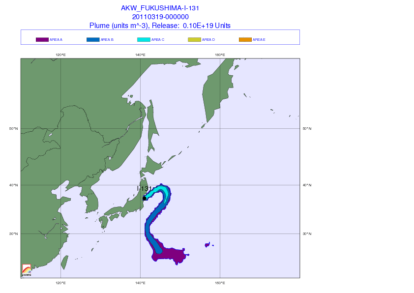
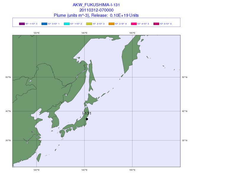
Remarks
- ↑ a b The run-up height (English: run-up height ) is here the height of the country to which the tsunami has penetrated, respectively. (Source: Miyako City Great East Japan Earthquake and Tsunami Records Editorial Committee: The Great East Japan Earthquake and Tsunami Records of Miyako City - Vol. 1, History of Tsunami (Summary Version) - English Edition ( Memento from August 20, 2018 on WebCite ) (PDF), Miyako City Iwate Prefecture, March 15, 2015 (Japanese original version: September 1, 2014).)
- ↑ According to the specifications for tsunami warnings and advisories published by the JMA in 2006, a large tsunami is indicated from an expected tsunami height of three meters for which a message of the category Tsunami Warning: Major tsunami (given here in English) is issued, which shows the predicted tsunami height specifically for each region, namely by means of the five height values 3 m, 4 m, 6 m, 8 m or ≥10 m. With an expected tsunami height of one or two meters, a tsunami is indicated for which a message of the category Tsunami Warning: Tsunami is issued, which also shows the predicted tsunami height specifically for each region, namely by means of the two height values 1 m or 2 m. With an expected tsunami height of around half a meter, a tsunami is indicated for which a message of the category Tsunami Advisory with the predicted tsunami height of 0.5 m is issued. Source: S. Fraser, GS Leonard, I. Matsuo, H. Murakami: Tsunami Evacuation: Lessons from the Great East Japan Earthquake and Tsunami of March 11th 2011 . In: GNS Science Report 2012/17 . Institute of Geological and Nuclear Sciences Limited, 2012, ISBN 978-0-478-19897-3 , ISSN 1177-2425 , 2.0, pp. I-VIII + 1–81 ( massey.ac.nz [PDF; accessed on June 29, 2018]). ; here: p. 8.) The classification of tsunami warnings and advisories was changed after the tsunami of 2011 and contains an emergency warning in the new version for tsunamis of 10m or more expected height . The Emergency Warning System was introduced by the JMA on August 30, 2013. (Source: Anawat Suppasri, Panon Latcharote, Jeremy D. Bricker, Natt Leelawat, Akihiro Hayashi, Kei Yamashita, Fumiyasu Makinoshima, Volker Roeber, Fumihiko Imamura: Improvement of Tsunami Countermeasures Based on Lessons from The 2011 Great East Japan Earthquake and Tsunami - Situation After Five Years . In: Coastal Engineering Journal . band 58 , no. 4 , 2016, p. 1640011-1 - 1640011-30 , doi : 10.1142 / S0578563416400118 . )
- ↑ a b c The Japanese term oki means " offshore ". Source: Junko Sagara, Keiko Saito: Risk Assessment and Hazard Mapping . In: Federica Ranghieri, Mikio Ishiwatari (Ed.): Learning from Megadisasters - Lessons from the Great East Japan Earthquake . World Bank Publications, Washington, DC 2014, ISBN 978-1-4648-0153-2 , Chapter 25, pp. 223–231 , doi : 10.1596 / 978-1-4648-0153-2 ( work accessible online on Google Books [accessed on April 3, 2018]). , License: Creative Commons Attribution CC BY 3.0 IGO.
- ↑ a b c d This calculation of the number of dead and missing is based on the total figures provided by the Fire and Disaster Management Agency (Japanese: isch 庁; English: Fire and Disaster Management Agency, FDMA) on March 8, 2016, minus of the numbers of catastrophic deaths provided by the Reconstruction Agency (Japanese: 復興 庁 ; English: Reconstruction Agency, RA): 平 成 23 年 (2011 年) 東北 地方 太平洋 沖 地震 (東 日本 大 震災) に つ い て (第 153 報) ( 平 成 23 年 (2011 年) 東北 地方 太平洋 沖 地震 (東 日本 大 震災) に つ い て (第 153 報) ( Memento of March 10, 2016 on WebCite )), 総 務 省 消防 庁 (Fire and Disaster Management Agency), 153rd report, March 8, 2016. Source: Tadashi Nakasu, Yuichi Ono, Wiraporn Pothisiri: Why did Rikuzentakata have a high death toll in the 2011 Great East Japan Earthquake and Tsunami disaster? Finding the devastating disaster's root causes . In: International Journal of Disaster Risk Reduction . tape 27 , 2018, p. 21-36 , doi : 10.1016 / j.ijdrr.2017.08.001 . (Published online on August 15, 2017), here p. 22, table 2.
- ↑ The data on the total population within the flooded areas come - unless otherwise stated in the table value - from: Statistics Bureau (統計局) and Director-General for Policy Planning (Volks 統 括 官), Census 2010 (cf. The Statistics Bureau: "Population and number of households in the estimated flooding region, preliminary figures of the 2010 census ", URL: http://www.stat.go.jp/info/shinsai/index.htm ). (Source: Nam Yi Yun, Masanori Hamada: Evacuation Behavior and Fatality Rate during the 2011 Tohoku-Oki Earthquake and Tsunami . In: Earthquake Spectra . Volume 31 , no. 3 , August 2015, p. 1237-1265 , doi : 10.1193 / 082013EQS234M . , here p. 1241, table 1.) The data according to Miyazawa (2011), for example, deviate significantly (downwards) from these values, for example for Miyako (11,740), Yamada (7,050), Ōtsuchi (9,300), Kamaishi (11,390 ), Ōfunato (8,990), Rikuzentakata (9,960), Kesennuma (20,880), Onagawa (5150), Ishinomaki (92,210), Higashimatsushima (28,800), Tagajō (13,160), Natori (10,430) and Iwanuma (6,570). (Source: H. Murakami, K. Takimoto, A. Pomonis: Tsunami Evacuation Process and Human Loss Distribution in the 2011 Great East Japan Earthquake - A Case Study of Natori City, Miyagi Prefecture . In: 15th World Conference on Earthquake Engineering . 2012 ( iitk.ac.in [PDF]). , Hitoshi Miyazawa: Population in areas affected by the 2011 tsunami off the Pacific coast caused by the Tohoku Earthquake: From Sanriku coast to Sendai Bay area . In: The 2011 East Japan Earthquake Bulletin of the Tohoku Geographical Association . May 7, 2011 ( tohokugeo.jp ). )
- ↑ The data on the flooded areas were provided by the Japanese land surveying authority (Japanese: 国土 地理 院 ; English: Geographical Survey Institute, GSI). (Sources: Tadashi Nakasu, Yuichi Ono, Wiraporn Pothisiri: Why did Rikuzentakata have a high death toll in the 2011 Great East Japan Earthquake and Tsunami disaster? Finding the devastating disaster's root causes . In: International Journal of Disaster Risk Reduction . Volume 27 , 2018, p. 21-36 , doi : 10.1016 / j.ijdrr.2017.08.001 . (Published online on August 15, 2017), here p. 22, table 2; National Institute for Land and Infrastructure Management (NILIM), Building Research Institute (BRI): Summary of the Field Survey and Research on "The 2011 off the Pacific coast of Tohoku Earthquake" (the Great East Japan Earthquake) . In: BRI Research Paper . No. 150 , September 2011, ISSN 0453-4972 , p. 1-165 . )
- ↑ The data on the population in the flooded area were taken from the statistical office of the Ministry of Internal Affairs and Communications (Japanese: 総 務 省; English: Ministry of Internal Affairs and Communications, MPHPT). (Source: Tadashi Nakasu, Yuichi Ono, Wiraporn Pothisiri: Why did Rikuzentakata have a high death toll in the 2011 Great East Japan Earthquake and Tsunami disaster? Finding the devastating disaster's root causes . In: International Journal of Disaster Risk Reduction . Volume 27 , 2018, p. 21-36 , doi : 10.1016 / j.ijdrr.2017.08.001 . (Published online on August 15, 2017), here p. 22, table 2.)