
Hilo
| Hilo | |
|---|---|
 Aerial view of Hilo Bay and the city |
|
| Location in Hawaii | |
 |
|
| Basic data | |
| State : | United States |
| State : | Hawaii |
| County : | Hawaii County |
| Coordinates : | 19 ° 44 ′ N , 155 ° 5 ′ W |
| Time zone : | Hawaii-Aleutian Standard Time ( UTC − 10 ) |
| Residents : | 43,263 (as of 2010) |
| Population density : | 307.5 inhabitants per km 2 |
| Area : | 151.4 km 2 (approx. 58 mi 2 ) of which 140.7 km 2 (approx. 54 mi 2 ) is land |
| Height : | 18 m |
| Postcodes : | 96720-96721 |
| Area code : | +1 808 |
| FIPS : | 15-14650 |
| GNIS ID : | 0359187 |
Hilo ( hiːloʊ ) with 43,263 inhabitants (2010), the largest town on Big Iceland in the US - State of Hawaii . It is also the capital of Hawaii County and therefore the entire island. Hilo is located on the bay called Hilo Bay in the northeast of the island.
geography
Geographical location
Hilo is close to the 4000 m high volcanoes Mauna Loa and Mauna Kea . A large number of astronomical instruments are located on the latter. The largest telescope in the world is operated here under the name Mauna Kea Observatory , including the two Keck telescopes , the Subaru telescope , as well as the northern Gemini telescope and the James Clerk Maxwell telescope.
climate
The location of the city is what makes Hilo one of the rainiest cities in the world. 3281 mm of precipitation falls annually. The location on Hilo Bay means that the city is particularly prone to tsunamis .
Due to the location on the rainy side of the island, the number of visitors on the "Hilo side" (east side) is significantly lower than the warmer, dry west side. In 2007, around 700,000 tourists visited the Hilo site. Hilo is a popular base for visits to Hawaii Volcanoes National Park , which is easily accessible from Highway 11. Helicopter flights over the volcanic areas also start at Hilo Airport.
| Hilo | ||||||||||||||||||||||||||||||||||||||||||||||||
|---|---|---|---|---|---|---|---|---|---|---|---|---|---|---|---|---|---|---|---|---|---|---|---|---|---|---|---|---|---|---|---|---|---|---|---|---|---|---|---|---|---|---|---|---|---|---|---|---|
| Climate diagram | ||||||||||||||||||||||||||||||||||||||||||||||||
| ||||||||||||||||||||||||||||||||||||||||||||||||
|
Average monthly temperatures and rainfall for Hilo
Source: wetterkontor.de
|
|||||||||||||||||||||||||||||||||||||||||||||||||||||||||||||||||||||||||||||||||||||||||||||||||||||||||||||||||||||||||||||||||||||||||||||||||||||||||||||||||||||||||||||||||||||||||||||||||||
Tsunami danger

In order to get the threat to the city from tsunamis under control, work began in 1900 to erect a barrier in Hilo Bay. This was completed in 1929. However, it proved useless when on April 1, 1946 a 14-meter-high tsunami destroyed large parts of the city and claimed a total of 159 lives. Cause of the flood was an earthquake of magnitude 8.6 off the Aleutian -Insel Unimak . The seiche of Hilo Bay intensified the destruction, i.e. the influence of the shape and size of the bay on the amplitude (wave height) of secondary waves of the actual tsunami.
One result of this disaster was the establishment of the Pacific Tsunami Warning Center . Nowadays, with the help of a large number of sensors, tsunamis that are forming in the entire Pacific can be forecast at short notice.
On May 23, 1960, Hilo was hit by another tsunami. A total of 61 people were killed. The main cause of the high number of fatalities despite the warning system was ignoring the warning sirens. This tidal wave was triggered by the Great Chile quake 10,000 km away, which with a magnitude of 9.5 was the strongest quake of the 20th century.
Demographics
In the 2010 Census , the 43,263 residents gave the following ethnicity: 17.6% “white”, 0.5% “black” or “African American”, 34.3% Asian, 10.3% Hawaiian, 3.9% other Pacific Islanders, 10.4% "Hispanic", 32.5% multiracial. 26.7% of the population were under 21 years of age.
Economy and Infrastructure
traffic
The Hilo International Airport connects Hilo with the other islands and the mainland. It is the second largest airport on the island after the Kona International Airport at Keahole . Various helicopter flight organizers are also based here. a. Offer flights to the lava fields on the south coast and the waterfalls in the area.
Hilo is connected to the island's public transport by the Hele-On bus .
media
The Hawaii Tribune-Herald , a subsidiary of the Stephens Media Group, appears in Hilo
education
The University of Hawaiʻi at Hilo with a campus in the south of downtown is part of the University of Hawaiʻi . The Waiakea School (High School and Intermediate School) is adjacent to the campus. The privately run Kamehameha School, which only accepts students of Hawaiian descent, also operates a location in Hilo.
Personalities
sons and daughters of the town
- Rodney Anoa'i (1966-2000), wrestler
- Gabe Baltazar (* 1929), jazz alto saxophonist
- Keiko Bonk
- Ed Case (* 1952), politician
- Wesley Correira
- Al Dacascos (* 1942), martial artist
- Harry Kim
- Robert Kiyosaki (* 1947), businessman and author of self-help books
- Troy Mandaloniz
- Gerald Okamura
- Brittni Paiva
- BJ Penn (* 1978), mixed martial arts and Brazilian Jiu-Jitsu fighter
- Bob Shane
- Ryan Higa
Others
gallery

Oil painting Hilo from the Bay by James Gay Sawkins with the snow-capped peaks of Mauna Loa and Mauna Kea in the background

Hilo residents flee the April 1, 1946 tsunami (Pacific Tsunami Museum in Hilo)
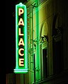
Palace Theater in Hilo

Liliʻuokalani Gardens in Hilo
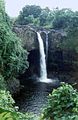
The Rainbow Falls (Ka Uao Waiānuenue, Rainbow Falls) near Hilo


Web links
- Hilo in the Geographic Names Information System of the United States Geological Survey
- Hilo Bay in the United States Geological Survey's Geographic Names Information System
- 1946 Tsunami - Hilo on YouTube . Photo and video recordings of the 1946 tsunami.
Individual evidence
- ↑ http://www.city-data.com/city/Hilo-Hawaii.html
- ↑ http://hawaii.gov/dbedt/info/visitor-stats/visitor-research/2007-annual-research.pdf
- ↑ US Census Bureau American Fact Finder, accessed July 31, 2017.