Unimak Island
| Unimak | ||
|---|---|---|
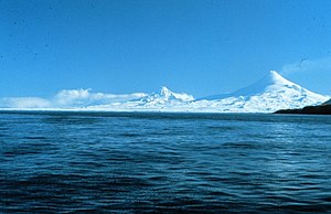
| The Shishaldin and Isanotski volcanoes on Unimak | ||
| Waters | Pacific Ocean | |
| Archipelago | Aleutian Islands | |
| Geographical location | 54 ° 46 ′ N , 164 ° 8 ′ W | |
|
|
||
| surface | 4th 069.9 km² | |
| Highest elevation |
Shishaldin 2857 m |
|
| Residents | 64 (2000) <1 inh / km² |
|
| main place | False pass | |
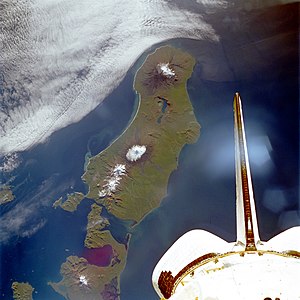
| Unimak from space | ||
Unimak Island is the largest and most easterly of the Aleutian Islands . It is only separated from the mainland at Kabuch Point by the Isanotski Strait , which is less than 700 meters wide at its narrowest point , which connects Ikatan Bay in the south with Bechevin Bay in the north. To the southeast, Unimak forms the Ikatan Peninsula, which is only connected to the island by a headland less than 500 meters wide. The outermost point of this peninsula is called Cape Pankof.
Unimak has one of the ten most active volcanoes in the world, the Shishaldin (2857 m). There is also the Pogromni volcano (2002 m) in the west of the island. Much of the island is glaciated due to the numerous elevations. The glaciers reach down to the coast.
fauna
The fauna of Unimak is largely similar to the mainland and represents the border to the barren fauna of the rest of the Alëuts. Reindeer (caribous) and brown bears live on the island. On the neighboring islands in the west of Unimak, only small animals live. B. the red fox .
traffic
The two airports Akutan Seaplane Base and Cape Sarichef Airport are located on Unimak .
The Unimak Pass in the southwest of the island is an important passage for merchant shipping from ports in the eastern Bering Sea . It separates Unimak from the Krenitzin and Fox Islands. False Pass on the east coast connects to the Alaska Marine Highway .
Web links
- Unimak on oceandots.com ( Memento from December 23, 2010 in the Internet Archive )


