False pass
| False pass | ||
|---|---|---|
|
Location in Alaska
|
||
| Basic data | ||
| Foundation : | October 19, 1990 | |
| State : | United States | |
| State : | Alaska | |
| Borough : | Aleutians East Borough | |
| Coordinates : | 54 ° 51 ′ N , 163 ° 25 ′ W | |
| Time zone : | Alaska ( UTC − 9 / −8 ) | |
| Residents : | 35 (as of 2010) | |
| Population density : | 0.5 inhabitants per km 2 | |
| Area : | 176.8 km 2 (approx. 68 mi 2 ) of which 69.9 km 2 (approx. 27 mi 2 ) is land |
|
| Height : | 9 m | |
| Postal code : | 99583 | |
| Area code : | +1 907 | |
| FIPS : | 02-24660 | |
| GNIS ID : | 1418574 | |
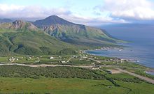
False Pass is a place with 64 inhabitants in the Aleutians East Borough of the US state Alaska and is located in the Aleutian Islands on the east coast of the island of Unimak . According to the United States Census 2000 , 62.5% of the population are of indigenous descent. An uninhabited part of False Pass is on the Alaska Peninsula, separated from the Aleutian Islands by Isanotski Strait .
Its name has its origin in the shallow depth of the Bering Sea at the northern end of Isanotski Strait , which makes it larger ships impossible to drive there, and for this the passage from the Gulf of Alaska thus "wrong" (Engl. False is) .
False Pass was first settled at the beginning of the 20th century. A fish processing factory started production in 1917 and was in operation until 1981 when it was destroyed by fire.
The place is connected to the ferry system of the Alaska Marine Highway .

