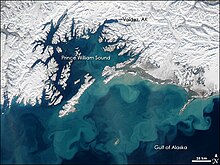
Gulf of Alaska
The Gulf of Alaska is an arm of the Pacific Ocean in southern Alaska between the Alaska Peninsula and Kodiak Island in the west to the Alexander Archipelago in the east with Glacier Bay and the Inside Passage .
Geography and climate
The entire coastline is rugged and is a combination of forests , rocks , mountains and many glaciers .
The Gulf often generates strong storms due to strong surface currents in interaction with cold air masses above the water , which run south on the Pacific coast and can reach as far as Mexico and bring abundant rainfall.
Precipitation in the western Pacific Northwest and California is often due to cloud formation in the Gulf of Alaska.
expansion
The International Hydrographic Organization defines the Gulf of Alaska as the sea area between the coast of Alaska in the north in a line from Cape Spencer to Kabuch Point , which includes the adjacent islands.
![]()
The United States Geological Survey defines the Gulf of Alaska as the sea area between the coast of Alaska to the north and a line between the southern tip of Kodiak Island and the Dixon Entrance .
See also
Web links
proof
- ↑ "Limits of Oceans and Seas, 3rd edition" (PDF; 994 kB)
- ^ Gulf of Alaska in the United States Geological Survey's Geographic Names Information System
Coordinates: 58 ° N , 148 ° W

