Wrangell (Alaska)
| Wrangell | ||
|---|---|---|
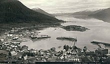
 Wrangell with Mount Dewey in the background |
||
| Location in Alaska | ||
|
|
||
| Basic data | ||
| Foundation : | 1834 | |
| State : | United States | |
| State : | Alaska | |
| Borough : | Wrangell City and Borough | |
| Coordinates : | 56 ° 28 ′ N , 132 ° 23 ′ W | |
| Time zone : | Alaska ( UTC − 9 / −8 ) | |
| Residents : | 2,369 (as of 2010) | |
| Population density : | 20.2 inhabitants per km 2 | |
| Area : | 183.5 km 2 (approx. 71 mi 2 ) of which 117.3 km 2 (approx. 45 mi 2 ) is land |
|
| Height : | 21 m | |
| Area code : | +1 907 | |
| FIPS : | 02-86380 | |
| GNIS ID : | 1415843 | |
Wrangell is a city and since June 1, 2008 an independent borough in the US state of Alaska . It is located in the so-called Alaska Panhandle . Before it became its own borough, it was part of the Wrangell-Petersburg Census Area . According to the 2010 census , 2369 people live here. The city name is Tlingit Khaachxhaana.áak'w in the local Indian language .
history
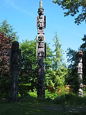
The area of today's Wrangell was inhabited by Stikine- Tlingit of the Nanya.aayí clan. Their main house was called the X'atgu.hít or Dogfish House, commonly known as the Chief Shakes House. Around the house on the island, which still exists today, stood totem poles from Katjisdu.á x ch II, who belonged to the Kiks.adí clan and is considered the greatest carving artist in Tlingit history. The powers he created in the four posts were extremely naturalistic and dated between around 1775 and 1790. The house posts in the Wrangell Museum are the oldest surviving Tlingit posts. They originally stood around a house in the old village of Wrangell, a place the Tlingit called Kasítłáan. However, this place was abandoned around 1834 and relocated to the present port in order to be able to compete with the Russian foundation of Wrangell. The totem poles stayed in their old location for more than a decade before they were rescheduled because the move was probably only planned temporarily. The two posts with the human representations must have been lying there because they were badly weathered. The house existed until 1938/39 when it was replaced by a replica.
Wrangell is one of the oldest settlements in Alaska that was not founded by the indigenous people, the Tlingit. In 1811 the Russians began to trade with the Tlingit in what is now Wrangell. In 1834 Ferdinand von Wrangel , then governor of Russian America , founded a warehouse 20 km north of the large Tlingit settlement of Kasítłáan. This warehouse was called Redoubt Saint Dionysius and stood exactly where the city of Wrangell is today. In 1840 the British Hudson's Bay Company (HBC) leased the building and named it Fort Stikine.
The native Tlingit Indians have always used the Stikine River as a trade route inland and now protested against the HBC when it also began to use its trade route. However, two smallpox epidemics between 1836 and 1840 reduced the Tlingit population by half and thus also stifled the uprisings.
The fort was abandoned in 1849 after there were no more sea otters and beavers to trade with. It remained under British lease until 1867 when Alaska was sold to the United States .
The settlement around the fort began to grow because of the gold rush in 1861, then even more in 1874–1877 and 1897. In 1868, Fort Wrangell was built, an outpost of the US Military Post . Similar to Skagway , many amusement arcades and dance bars were built up out of the ground. Thousands of prospectors traveled from here over the Stikine River to the Cassiar District of British Columbia in 1874 and to the Klondike in 1897 .
Wrangell has the exclusive status of being the only city in Alaska to be under four different flags of government. These include Russia , England , the USA and Tlingit.
In 1895, Chief Shake erected a totem pole on the island.

Today many people in Wrangell work as lumberjacks, fishermen or earn money from tourism. One of the two most important sawmills in southeast Alaska is operated by the Silver Bay Company just south of the city limits.
The Chief Shakes Clan House was demolished in 1938/39 and replaced by the current house, a 1940 reconstruction built by the Civilian Conservation Corps . The totem poles on the island, which is called Chief Shakes Island , stood until 1982 and were replaced by replicas from 1984. On July 2, 1987, the island with its house and stake inventory was placed under protection.
The borough was formed on June 1, 2008.
Four structures and sites in the borough are listed on the National Register of Historic Places (NRHP) (as of April 25, 2020): the Chief Shakes Historic Site , the Etolin Canoe , the Judith Ann riverboat and St. Philip's Episcopal Church
geography
Wrangell is located on the northern tip of Wrangell Island , an island in the Alaska Panhandle . It is located about 250 km south of Juneau , the capital of Alaska. The city was named after the island of the same name, which in turn was named after Ferdinand von Wrangel , a Russian explorer and later governor of Russian America .
Demographics
According to the 2010 census, Wrangell has 2,369 people in 907 households and 623 families. The population density is 19.7 / km 2 . There are 1092 buildings, which corresponds to a density of 9.3 / km 2 . 73.48% of the population is European, 0.13% Afro-American, 15.51% Tlingit, 0.65% Asian. Additionally, 0.13% are Pacific Islanders, 0.35% are of other ancestry, and 9.75% are mixed race. 1.0% of the population are Latinos.
Transport / infrastructure
Because of its exclusive island location, there are only two main modes of transport: the ferry and the plane.
There are several regular ferry lines such as the AMHS that connect Wrangell to the rest of Southeast Alaska. From the air, which is Wrangell Airport from the Alaska Airlines fly.
museum
In the James & Elsie Nolan Center, after a generous donation and negotiations that dragged on for decades, the Wrangell Museum was created. The posts of Chief Shake's original house are in the museum, which received $ 6 million in 2004. The oldest pieces are the aforementioned totem poles.
Petroglyph Park
About 2 km north of City Dock is Petroglyph Beach, a State Historical Park with around 40 images.
Surroundings
The Shakes Glacier is located 40 km north-northeast of Wrangell in the Stikine-LeConte Wilderness .
literature
- EL Keithahn: The Authentic History of Shakes Island and Clan , Wrangell 1981
- Donald Craig Mitchell: Sold American. The Story of Alaska Natives and their Land, 1867–1959 , Fairbanks: University of Alaska Press 1997, reprinted in 2003
Web links
Individual evidence
- ^ Wrangell (Alaska) in the Geographic Names Information System of the United States Geological Survey
- ^ Chief Shakes Historic Site on the National Register Information System. National Park Service , accessed April 25, 2020.
- ↑ Charles Curry Aiken, Joseph Nathan Kane: The American Counties: Origins of County Names, Dates of Creation, Area, and Population Data, 1950-2010 . 6th edition. Scarecrow Press, Lanham 2013, ISBN 978-0-8108-8762-6 , p. 335.
-
↑ Search mask database in the National Register Information System. National Park Service , accessed April 25, 2020.
Weekly List on the National Register Information System. National Park Service , accessed April 25, 2020. - ↑ Charles Curry Aiken, Joseph Nathan Kane: The American Counties: Origins of County Names, Dates of Creation, Area, and Population Data, 1950-2010 . 6th edition. Scarecrow Press, Lanham 2013, ISBN 978-0-8108-8762-6 , p. 335.


