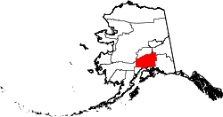
Matanuska-Susitna Borough
| administration | |
|---|---|
| US state : | Alaska |
| Administrative headquarters : | Palmer |
| Foundation : | 1964 |
| Demographics | |
| Residents : | 59,322 (2000) |
| Population density : | 0.9 inhabitants / km 2 |
| geography | |
| Total area : | 65,423 km² |
| Water surface : | 1498 km² |
| map | |
| Website : www.co.mat-su.ak.us | |
The Matanuska-Susitna Borough (colloquially: Mat-Su) is a borough (administrative district) in the state of Alaska in the United States of America . The borough seat is Palmer and the largest city is Wasilla .
geography
The Matanuska River and the Susitna River flow through the borough . The two rivers flow into the Cook Inlet , which is the southern border of the borough. The Matanuska-Susitna Borough is home to some of the few agricultural areas in Alaska. Parts of the Chugach National Forests and the Denali and Lake Clark National Parks are in the borough. Alaska's three major highways run through the borough, the Glenn Highway , the George Parks Highway, and the Denali Highway . The total area of the borough is 65,423 square kilometers, of which 63,925 square kilometers are land and 1,498 square kilometers (2.29 percent) are water.
history
The borough was formed in January 1964. The double name is derived from Russian and means on the one hand "people from the Copper River " ("matanooska"), while "Susitna" is the Russian rendering of the Dena'ina name for the Sandy River.

29 buildings and sites in the city are listed on the National Register of Historic Places (NRHP) (as of April 23, 2020), including the Fairview Inn , the Talkeetna Historic District and the Teeland's Country Store .
Demographics
At the time of the 2000 census ( US Census 2000 ), the borough had 59,322 inhabitants on a land area of 63,925 square kilometers. The median age was 34.1 years (US national mean: 35.3 years). The per capita income (engl. The per capita income ) amounted to US $ 21,105 (national average of USA: US $ 21,587). The income of 11.0 percent of the population was below the poverty line (US national average: 12.4 percent).
Individual evidence
- ↑ Charles Curry Aiken, Joseph Nathan Kane: The American Counties: Origins of County Names, Dates of Creation, Area, and Population Data, 1950-2010 . 6th edition. Scarecrow Press, Lanham 2013, ISBN 978-0-8108-8762-6 , p. 197.
- ↑ tea country's Country Store register in the National Information System. National Park Service , accessed April 23, 2020.
-
↑ Search mask database in the National Register Information System. National Park Service , accessed April 23, 2020.
Weekly List on the National Register Information System. National Park Service , accessed April 23, 2020. - ↑ factfinder.census.gov
Web links
Coordinates: 62 ° 24 ′ N , 149 ° 35 ′ W
