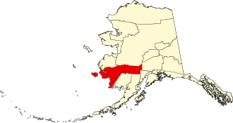
Bethel Census Area
The Bethel Census Area is a census area in the US state of Alaska . It extends inland from the coast of Bristol Bay and the Yukon-Kuskokwim Delta and includes the island of Nunivak in the Bering Sea .
In 2010 the population was 17,013. Bethel is part of the Unorganized Borough and therefore has no administrative headquarters. The census area has an area of 117,866 km², of which 105,240 km² is land and 12,627 km² is water. The largest city in the region is Bethel .
Parts of the National Wildlife Refuges Alaska Maritime , Togiak and Yukon Delta as well as the Lake Clark National Park are located in the Bethel Census Area.
history
The Cenus Area was named after the Bethel Mission , which was a church of the Moravian Brethren founded in the region in 1884 .
Seven structures and sites in the Census Area are listed on the National Register of Historic Places (NRHP) (as of April 28, 2020), six of which are churches and chapels and the Kolmakov Redoubt Site .
Web links
- QuickFacts on census.gov (English)
Individual evidence
- ↑ Charles Curry Aiken, Joseph Nathan Kane: The American Counties: Origins of County Names, Dates of Creation, Area, and Population Data, 1950-2010 . 6th edition. Scarecrow Press, Lanham 2013, ISBN 978-0-8108-8762-6 , p. 23.
- ↑ St. Sergius Chapel in the National Register Information System. National Park Service , accessed April 28, 2020.
-
↑ Search mask database in the National Register Information System. National Park Service , accessed April 28, 2020.
Weekly List on the National Register Information System. National Park Service , accessed April 28, 2020.
Coordinates: 60 ° 48 ′ N , 161 ° 36 ′ W

