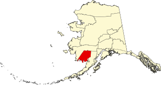
Dillingham Census Area
The Dillingham Census Area is a census area in the US state of Alaska on the north coast of Bristol Bay , west of the Alaska Peninsula .
In 2010 the population was 4847. Dillingham is part of the Unorganized Borough and therefore has no administrative headquarters. The census area has an area of 54,204 km², of which 48,367 km² is land and 5837 km² is water. The largest city in the region is Dillingham .
Parts of the Togiak National Wildlife Refuge and Hagemeister Island, which is part of the Alaska Maritime National Wildlife Refuge, are located in the Dillingham Census Area.
history
The Census Area was formed on April 24, 1989 and named after the politician William P. Dillingham . This was from 1903 to 1923 Senator in Washington, DC and in 1903 led a visit of a subcommittee of the Senate in the District of Alaska . He was considered the Alaska expert in the Senate.

Three buildings and sites in the Census Area are listed on the National Register of Historic Places (NRHP) (as of April 28, 2020), including the Walrus Islands Archeological District, which has the status of a National Historic Landmark .
See also
Web links
- QuickFacts on census.gov (English)
Individual evidence
- ↑ Charles Curry Aiken, Joseph Nathan Kane: The American Counties: Origins of County Names, Dates of Creation, Area, and Population Data, 1950-2010 . 6th edition. Scarecrow Press, Lanham 2013, ISBN 978-0-8108-8762-6 , p. 86.
- ↑ Listing of National Historic Landmarks by State: Alaska. National Park Service , accessed April 28, 2020.
-
↑ Search mask database in the National Register Information System. National Park Service , accessed April 28, 2020.
Weekly List on the National Register Information System. National Park Service , accessed April 28, 2020.
Listing of National Historic Landmarks by State: Alaska. National Park Service , accessed April 28, 2020.
Coordinates: 59 ° 6 ′ N , 158 ° 30 ′ W
