Aleutians East Borough
| administration | |
|---|---|
| US state : | Alaska |
| Administrative headquarters : | Sand point |
| Foundation : | 1986 |
| Demographics | |
| Residents : | 3141 (2010) |
| Population density : | 0.2 inhabitants / km 2 |
| geography | |
| Total area : | 38,880 km² |
| Water surface : | 20,781 km² |
| map | |
The Aleutians East Borough (German: District of Eastern Aleutian Islands ) is a district in the state of Alaska in the United States of America . 2697 inhabitants live here. The borough seat is Sand Point .
The district has an area of 38,880 square kilometers, which is slightly more than the area of Baden-Württemberg . Of this, 18,099 square kilometers are land and 20,781 square kilometers (53.45 percent) are water.
The borough includes the western part of the Alaska Peninsula and some islands of the eastern Aleutian Islands such as the Pavlof Islands and the Sanak Islands and the Shumagin archipelago .
Parts of the National Wildlife Refuges Alaska Maritime and Alaska Peninsula as well as the entire Izembek National Wildlife Refuge are located in the Aleutians East Borough .
The region has been inhabited by the Unangan since the last Ice Age . First contacts with Europeans took place through Russian fur traders. Many residents were evacuated to Ketchikan during the Battle of the Aleutian Islands in World War II .
The borough was formed on October 23, 1987.

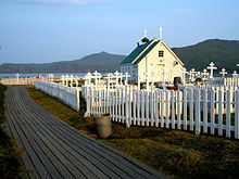
Four structures and sites in the borough are listed on the National Register of Historic Places (NRHP) (as of April 15, 2020): Holy Resurrection Church , Port Moller Hot Springs Village Site , St. Alexander Nevsky Chapel and St. Nicholas Chapel .
Web links
- Alaska community database: Aleutians East Borough (detailed information )
- Database of Municipalities Alaska: Aleutians East Borough (English)
Individual evidence
- ↑ Charles Curry Aiken, Joseph Nathan Kane: The American Counties: Origins of County Names, Dates of Creation, Area, and Population Data, 1950-2010 . 6th edition. Scarecrow Press, Lanham 2013, ISBN 978-0-8108-8762-6 , pp. 4f.
-
↑ Search mask database in the National Register Information System. National Park Service , accessed April 15, 2020.
Weekly List on the National Register Information System. National Park Service , accessed April 15, 2020.
Coordinates: 55 ° 14 ′ N , 161 ° 55 ′ W
