
Prince of Wales-Hyder Census Area

(since May 19, 2008)

(until May 19, 2008)
The Prince of Wales-Hyder Census Area is a census area in the US state of Alaska in the southeast of the Alaska Panhandle . On May 19, 2008, large parts of the Census Area, which until then was called Prince of Wales-Outer Ketchikan , fell to the Ketchikan Gateway Borough . Because the Outer Ketchikan region had also been spun off, the name was changed to Prince of Wales-Hyder .
While the Prince of Wales-Outer Ketchikan Census Area represented a continuous territory that the Ketchikan Gateway Borough , is enclosed the Prince of Wales-Hyder Census Area mainly from the Prince of Wales Island and a small area around the town of Hyder in the border with the Canadian province of British Columbia .
In 2010 the population was 5,559. The Prince of Wales-Outer Ketchikan Census Area had an area of 32,909 km², of which 19,193 km² is land and 13,716 km² is water.
Prince of Wales-Hyder belongs to the Unorganized Borough and therefore has no administrative headquarters.
Parts of the Alaska Maritime National Wildlife Refuge , Misty Fjords National Monument and Tongass National Forest are in the Census Area.
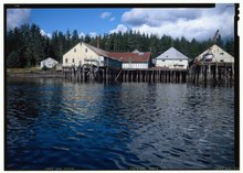
Six buildings and sites in the Census Area are listed on the National Register of Historic Places (NRHP) (as of April 29, 2020), including the Kake Cannery with the status of a National Historic Landmark .
Individual evidence
- ↑ US Census Bureau ( Memento of the original from March 25, 2010 in the Internet Archive ) Info: The archive link was inserted automatically and has not yet been checked. Please check the original and archive link according to the instructions and then remove this notice.
- ↑ Listing of National Historic Landmarks by State: Alaska. National Park Service , accessed April 29, 2020.
-
↑ Search mask database in the National Register Information System. National Park Service , accessed April 29, 2020.
Weekly List on the National Register Information System. National Park Service , accessed April 29, 2020.
Listing of National Historic Landmarks by State: Alaska. National Park Service , accessed April 29, 2020.
Web links
- QuickFacts on census.gov (English)
- Map of the Prince of Wales-Hyder Census Area (PDF file; 365 kB)
| Boroughs |
Aleutians East | Anchorage | Bristol Bay | Denali | Fairbanks North Star | Haines | Juneau | Kenai Peninsula | Ketchikan Gateway | Kodiak Island | Lake and Peninsula | Matanuska-Susitna | North Slope | Northwest Arctic | Petersburg Borough | Skagway | Sitka | Wrangell | Yakutat | Unorganized Borough |
|
| Census Areas |
Aleutians West | Bethel | Dillingham | Hoonah-Angoon | Kusilvak | Nome | Prince of Wales-Hyder | Southeast Fairbanks | Valdez-Cordova | Yukon-Koyukuk |
Coordinates: 55 ° 30 ′ N , 132 ° 48 ′ W