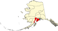
Kenai Peninsula Borough
| administration | |
|---|---|
| US state : | Alaska |
| Administrative headquarters : | Soldotna |
| Address of the administrative headquarters: |
144 North Binkley Street Borough Seat Soldotna, AK 99669-7599 |
| Foundation : | |
| Area code : | 907 |
| Demographics | |
| Residents : | 58,506 (2016) |
| Population density : | 1.4 inhabitants / km 2 |
| geography | |
| Total area : | 64,114 km² |
| Water surface : | 22,640 km² |
| map | |
| Website : www.borough.kenai.ak.us | |
The Kenai Peninsula Borough is a borough (district) in the state of Alaska in the United States of America with 55,400 inhabitants (as of 2010). The administrative seat is Soldotna .
geography
The borough lies on both sides of the Cook Inlet between the Alaska Range and the Kenai Peninsula , on which the Kenai Fjords National Park is located. The borough has a total area of 64,114 square kilometers; of which 41,474 square kilometers are land and 22,640 square kilometers (35.31 percent) are water.
history
The borough was established with effect from January 1, 1964 on September 13, 1963. It was named after the Kenaitze people who lived here. This name, in turn, has Russian roots and comes from Kenayskaya , the name for Cook Inlet .

35 buildings and sites in the city are registered on the National Register of Historic Places (NRHP) (as of April 21, 2020), including the Holy Assumption of the Virgin Mary Church and the Yukon Island Main Site have the status of National Historic Landmarks .
towns and places
|
|
Web links
Individual evidence
- ↑ Charles Curry Aiken, Joseph Nathan Kane: The American Counties: Origins of County Names, Dates of Creation, Area, and Population Data, 1950-2010 . 6th edition. Scarecrow Press, Lanham 2013, ISBN 978-0-8108-8762-6 , p. 160.
- ↑ Listing of National Historic Landmarks by State: Alaska. National Park Service , accessed April 21, 2020.
-
↑ Search mask database in the National Register Information System. National Park Service , accessed April 21, 2020.
Weekly List on the National Register Information System. National Park Service , accessed April 21, 2020.
Listing of National Historic Landmarks by State: Alaska. National Park Service , accessed April 21, 2020.
Coordinates: 60 ° 12 ′ N , 151 ° 38 ′ W
